MESONET TICKER ... MESONET TICKER ... MESONET TICKER ... MESONET TICKER ...
December 21, 2015 December 21, 2015 December 21, 2015 December 21, 2015
It could snow in Oklahoma this weekend...a LOT!
Or not. This graphic from the NWS forecast office in Amarillo sums up the storm
for next weekend pretty well.
http://ticker.mesonet.org/archive/20151221/nws-ama-weekend.forecast.gif
But the forecast models have been doing that "uncertain" thing they do so well
with a system 6 or 7 days out. The NWS forecasters have been trying to get a
handle on the chaos.
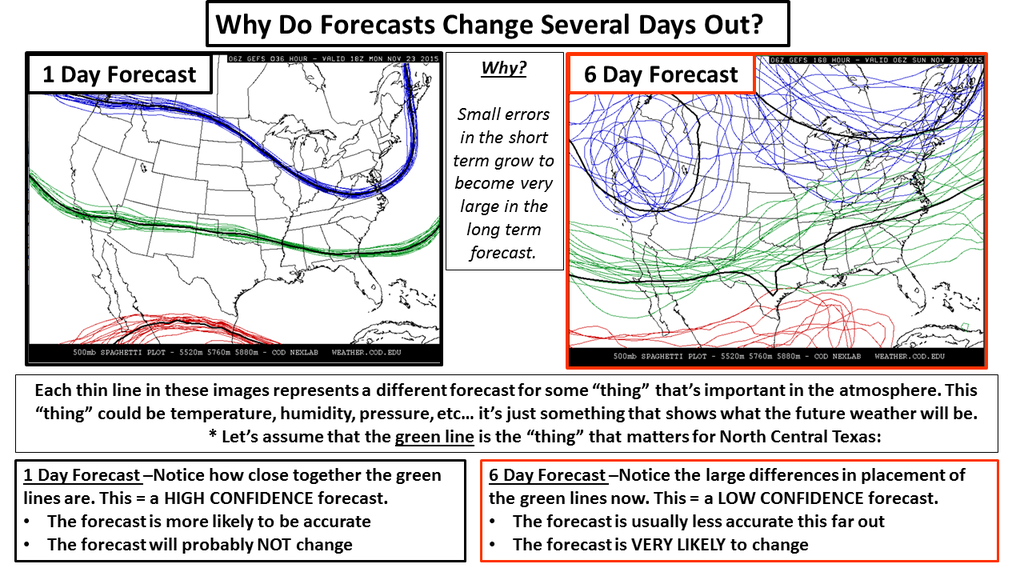
Chaos? Remember this graphic from the Ft. Worth NWS office? This explains quite
well what's been going on with the models.
http://ticker.mesonet.org/archive/20151123/forecasting-chaos.png
And here are some tidbits from local NWS forecasters on trying to decipher those
model runs. This is also where they use their experience with what they know about
each model and how it handles storms of this nature. Still, the chaos is hard
to overcome.
NWS-Amarillo
" THE STRENGTH AND TRACK OF THE
CLOSED LOW INDICATED BY THE LATEST OPERATIONAL GFS AND ECMWF RUNS
WOULD RESULT IN A SIGNIFICANT WINTER STORM ACROSS THE PANHANDLES THIS
WEEKEND. THAT BEING SAID...CONFIDENCE IS STILL QUITE LOW IN EXACTLY
WHAT WILL PLAY OUT AT THIS TIME DUE TO THE EXTREME VOLATILITY AND
POOR CONSISTENCY MODELS HAVE SHOWN WITH THIS SYSTEM OVER THE PAST FEW
DAYS. THUS WILL HAVE TO SEE IF THIS BETTER AGREEMENT ON LATEST
GUIDANCE CONTINUES...THEREBY LENDING GREATER CONFIDENCE TO SUBSEQUENT
FORECASTS."
NWS-Norman
"CHRISTMAS DAY THROUGH SUNDAY...WILL CONTINUE TO MONITOR A STORM
SYSTEM THAT WILL LIKELY AFFECT THE SOUTHERN PART OF THE NATION.
MOST MODEL GUIDANCE NOW DEPICT THAT A CLOSED MID/UPPER LOW WILL
MOVE ACROSS THE SOUTHERN PART OF THE NATION. THIS SOLUTION WOULD
BE MORE FAVORABLE FOR HEAVY PRECIPITATION ACROSS OKLAHOMA AND
NORTH TEXAS. EXACT TIMING...LOCATION...AND PRECIPITATION TYPES
REMAIN VERY UNCERTAIN. A WIDE VARIETY OF WEATHER RANGING FROM
STRONG STORMS TO HEAVY RAIN/FLOODING TO ACCUMULATING WINTRY
PRECIPITATION COULD OCCUR ACROSS THE SOUTHERN PLAINS. FOR
NOW...WENT WITH THUNDERSTORM MENTION LATE ON CHRISTMAS DAY
TRANSITIONING TO A RAIN AND SNOW MIX SATURDAY NIGHT INTO SUNDAY
ACROSS THE NORTHWEST HALF OF OKLAHOMA. THE AMOUNT OF AVAILABLE
MOISTURE WITH THIS SYSTEM SEEMS TO BE ANOMOLOUSLY HIGH."
NWS-Tulsa
"ECMWF model more in line with the slower GFS solution,
developing a rather potent closed upper level low over Southern AZ
Saturday, moving system into Western Texas on Sunday. Given this
track, expect widespread rain with embedded thunderstorms to
develop along approaching cold front Saturday and continue on
Sunday as surface low develops and potentially tracks into
Southeast Oklahoma. Forecast precipitable water values around 1.8
inches is virtually off the charts for December and heavy rainfall
would be likely with the potential for flooding and possibly
severe weather depending on frontal position. Obviously, this
storm system is several days out and the eventual track of the
upper low will have a significant impact on the forecast. Overall
timing/evolution and associated threats will continue to be
refined in the coming days."
We thank the Tulsa office for not yelling. But, you might have noticed both the
Norman and Tulsa offices mentioning the amount of water available in this storm
being a tad high for December. Another gift from El Nino? Hard to say, but the
rainfall amounts could be extreme.
http://ticker.mesonet.org/archive/20151221/7day-precip-forecast.gif
http://ticker.mesonet.org/archive/20151221/nws-tulsa-heavy.rain.png
6 inches of rain the last week of December. Right. Real nice. And what if some
of that comes with some cold air? Real nice.
We will leave you with some words of wisdom from the Norman NWS office, because
something uncertain is certainly going to happen this weekend.
"THIS STORM SYSTEM MAY HAVE SIGNFICANT IMPACTS TO THE AREA. IT IS
ADVISED TO PAY CLOSE ATTENTION TO THE LATEST FORECASTS."
It would seem yelling might be appropriate in this instance.
Gary McManus
State Climatologist
Oklahoma Mesonet
Oklahoma Climatological Survey
(405) 325-2253
gmcmanus@mesonet.org
==================================================
The OCS/Mesonet Ticker
https://ticker.mesonet.org/
To subscribe or unsubscribe from the Ticker
or for questions about the Ticker or its content
Phone or Email the Ticker Manager at OCS
Phone: 405-325-2253 Email: ticker@mesonet.org
---------------------------------------------------
-C- Copyright 2024 Oklahoma Climatological Survey
===================================================
|


 Tweet
Tweet