MESONET TICKER ... MESONET TICKER ... MESONET TICKER ... MESONET TICKER ...
November 25, 2015 November 25, 2015 November 25, 2015 November 25, 2015
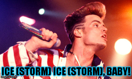
Eh, who needs power anyway?
http://ticker.mesonet.org/archive/20151125/ice.storm.jpg
All right stop, collaborate and listen (to the Norman NWS office as they explain
a particular worry for the next few days)!
"OUR WINTER STORM WATCH REMAINS UNCHANGED FROM THE EARLIER
ISSUANCE. IT STILL APPEARS THAT FREEZING RAIN IS LIKELY TO CAUSE
ICE ACCUMULATION IN THAT AREA...BEGINNING THURSDAY EVENING...AND
CONTINUING FRIDAY AND FRIDAY NIGHT/SATURDAY MORNING. IT APPEARS
FAIRLY LIKELY AT THIS POINT THAT SOME PARTS OF THE WATCH WILL HAVE
TO BE UPGRADED TO AN ICE STORM WARNING ONCE THERE IS SUFFICIENT
CONFIDENCE TO DO SO."
ARGH! "Ice storm warning," the most dreaded words in Oklahoma weather next to
"tornado warning," I reckon. Nothing can cause more havoc and chaos, it seems.
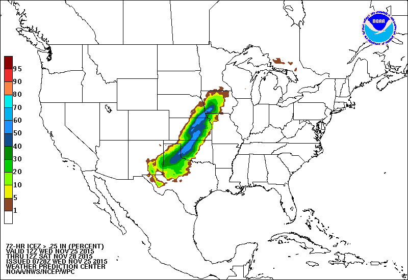
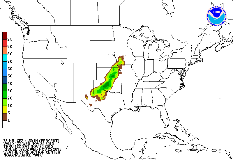
Check out these 3-day ice accumulation PROBABILITY maps from the WPC for both a
quarter-inch and a half-inch.
http://ticker.mesonet.org/archive/20151125/72hr-ice.accum.prob.quarter-inch.png
http://ticker.mesonet.org/archive/20151125/72hr-ice.accum.prob.half-inch.png
Yikes! Up to a 40% chance to see about a half-inch of ice across west central OK,
and possibly a 70% chance to see up to a quarter-inch. This is still fluid (and
I hope it stays that way, pardon the pun), but aye, there's the rub. What's the
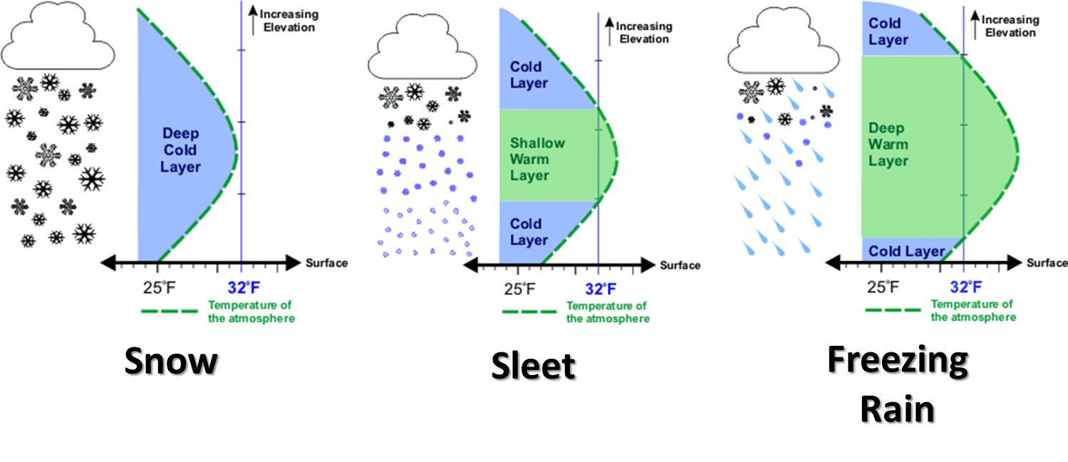
atmospheric setup going to be over the next three days as this gargantuan, wet
storm system passes over us? In particular, what's the vertical temperature
profile going to be, which is the key to determining what type of precipitation,
wintry or not, that you're going to get?
http://ticker.mesonet.org/archive/20131125/winter-precip-types.png
As of now, there is a winter storm watch for the NW third of the state and a
flash flood watch for the rest of the state (sans McCurtain County for now,
which will change soon I'm sure. There is just way too much water for this
storm to work with for this late in November.
http://ticker.mesonet.org/archive/20151125/7day-precip-forecast.gif
All thanks to a very warm Gulf of Mexico bringing moisture north on those strong
southerly winds you're feeling outside right now
http://ticker.mesonet.org/archive/20151125/current.gustarrows.gif
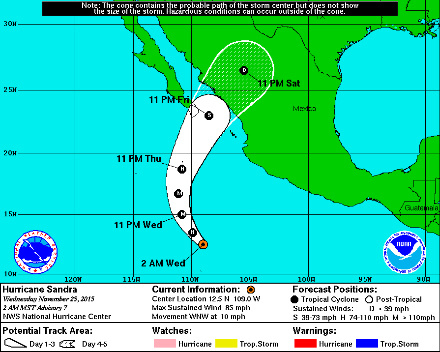
and stupid Hurricane Sandra in the Pacific, who's going to provide a nice fetch
of upper-level moisture from the other side of the Divide.
http://ticker.mesonet.org/archive/20151125/sandra.gif
That gives us all of the above. An easier way to have written this Ticker would
have been to just show a few graphics from our local NWS offices:
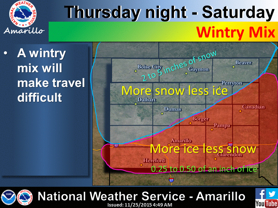
http://ticker.mesonet.org/archive/20151125/nws-amarillo-ice.snow.gif
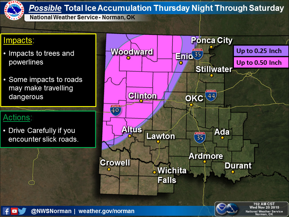
http://ticker.mesonet.org/archive/20151125/nws-norman-ice.jpg
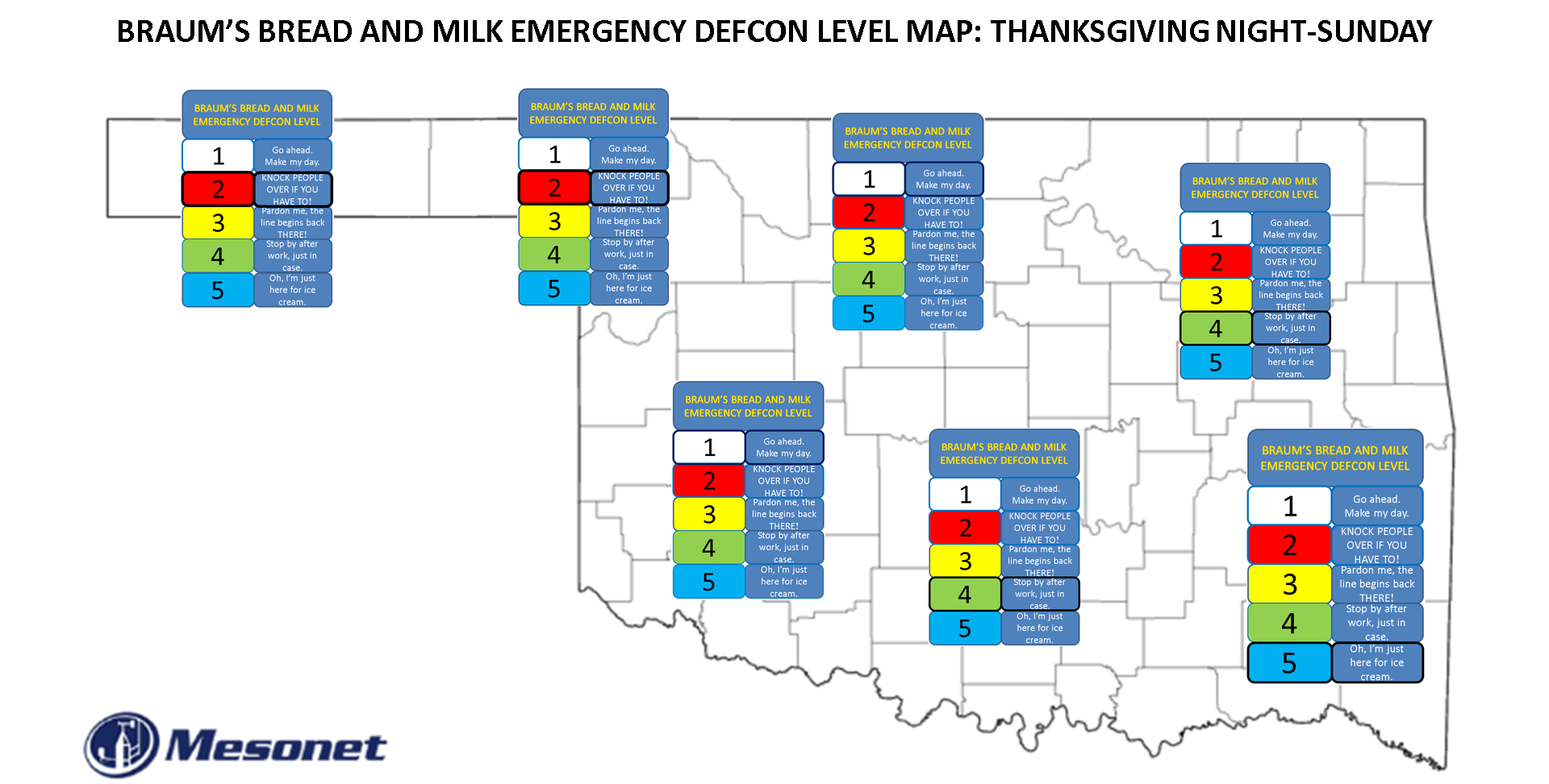
Given the recent developments, I'm afraid we're going to have to upgrade the
EMERGENCY BREAD AND MILK DEF-BRAUMS LEVEL to LEVEL ONE across west central
through north central Oklahoma.
http://ticker.mesonet.org/archive/20151125/DEF-BRAUMS-MAP.png
For the REAL info, however, you know the drill. Stay tuned to your local NWS
office and media outlets for the latest weather, because this one is definitely
going to be one of those hour-to-hour deals. For your ease, the Mesonet can
show you all the advisories and forecast graphics from the NWS in two very easy
to navigate pages.
http://www.mesonet.org/index.php/forecast/local_and_regional
http://www.mesonet.org/index.php/weather/category/advisories
And there ain't no better place to keep track of that freezing line than right
here on our own gem of a network, the Oklahoma Mesonet itself!
http://www.mesonet.org/index.php/weather/map/air_temperature/air_temperature
Beware that 32 degrees line. It's the key.
Gary McManus
State Climatologist
Oklahoma Mesonet
Oklahoma Climatological Survey
(405) 325-2253
gmcmanus@mesonet.org
==================================================
The OCS/Mesonet Ticker
https://ticker.mesonet.org/
To subscribe or unsubscribe from the Ticker
or for questions about the Ticker or its content
Phone or Email the Ticker Manager at OCS
Phone: 405-325-2253 Email: ticker@mesonet.org
---------------------------------------------------
-C- Copyright 2024 Oklahoma Climatological Survey
===================================================
|


 Tweet
Tweet