MESONET TICKER ... MESONET TICKER ... MESONET TICKER ... MESONET TICKER ...
August 18, 2022 August 18, 2022 August 18, 2022 August 18, 2022
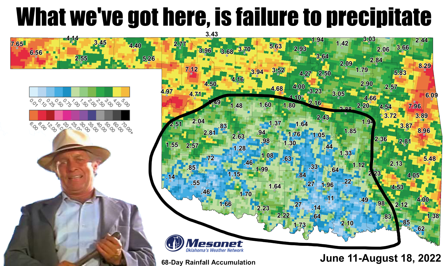
Cool Hand Drought
https://ticker.mesonet.org/archive/20220818/june11-aug18-rain-totals.png
I can't eat 50 eggs. Not that that is important, I just thought I'd get it out
there to begin with. I love transparency. And apparently so does my scalp. AND if
you haven't seen "Cool Hand Luke" at least 38 times, "pity" is not a strong enough
word. At any rate, the area highlighted above is indicative of the parts of
Oklahoma that are woefully behind on rainfall since this flash drought began
back on June 11. There are definitely places outside of that black blob I drew
that are also woefully--even pitifully--behind ("pitifully behind" was my nickname
in college), but that is the larger-scale area that has missed out. We can look
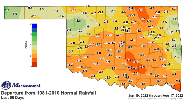
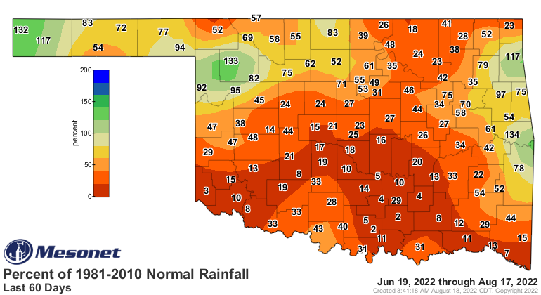
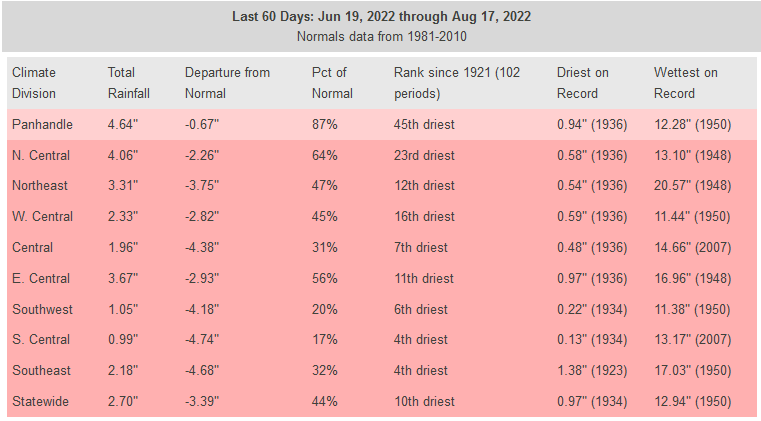
back at the 60-day rainfall departures to get a more clear picture on the damage
done.
https://ticker.mesonet.org/archive/20220818/del60day_rain.current.png
https://ticker.mesonet.org/archive/20220818/pct60day_rain.current.png
https://ticker.mesonet.org/archive/20220818/60day-rain-stats.png
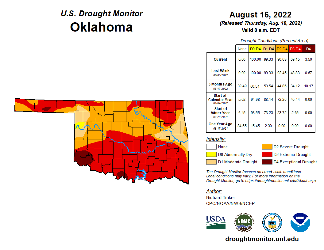
And that is the basis for most of the drought coverage we see today on the Drought
Monitor map.
https://ticker.mesonet.org/archive/20220818/20220816_ok_trd.png
HOWEVER, let's not forget that we're coming up on about a year from when the
longer-term drought really started ramping up.
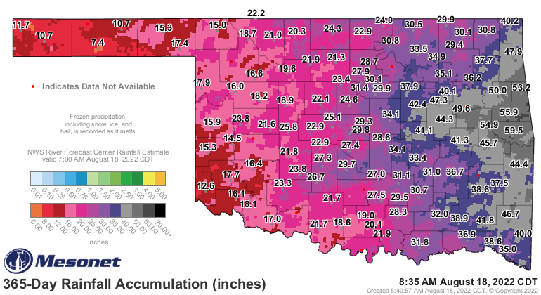
https://ticker.mesonet.org/archive/20220818/365day-rain-totals.png
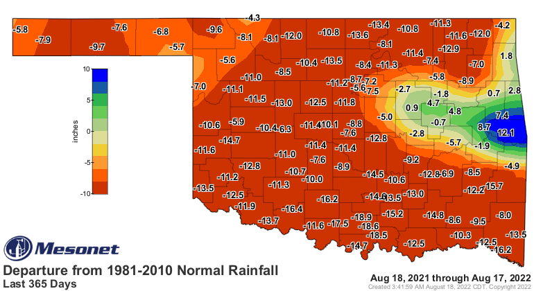
https://ticker.mesonet.org/archive/20220818/del365day_rain.current.png
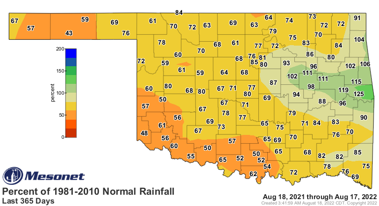
https://ticker.mesonet.org/archive/20220818/pct365day_rain.current.png
We have some good news and bad news from our prognosticating friends. And
enemies. NEVER borrow money from the Climate Prediction Center. If you don't pay
it back, they send bad outlooks your way. Luckily, in this case, we have some
good outlooks to work with as we go out over the next few months.
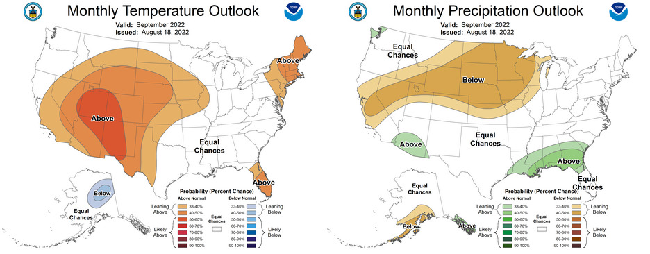
For September, at least, we do see increased odds of above normal temperatures
across western OK, but for the rest of the state, and ALL of the state for
the precipitation outlook, we see equal chances of above-, below-, and near-
normal temp and precip.
https://ticker.mesonet.org/archive/20220818/september-outlooks.png
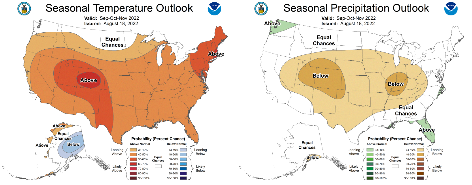
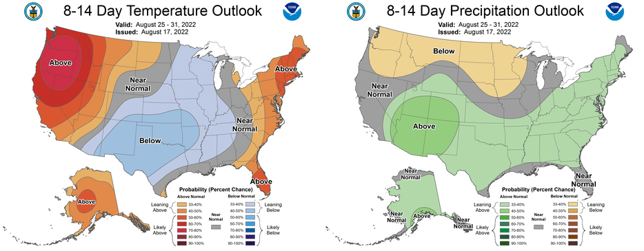
But when we get out into the seasonal outlook, good for today through the end
of November, it gets a bit more dicey. Here we can see increased odds of above
normal temps and below normal precip for the entire state, but those odds are
increased in the Panhandle for both.
https://ticker.mesonet.org/archive/20220818/sept-nov-outlooks.png
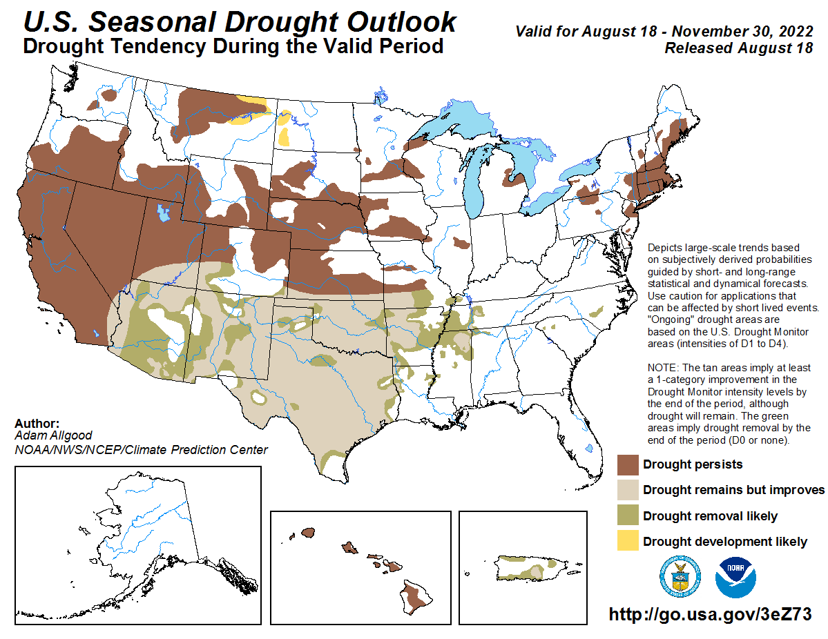
So the drought outlook for today through the end of November was something of a
compromise between the September vs. the September-November outlooks. Here we
can see drought improvement across the entire state with a few areas of drought
removal being considered "likely," but the drought remains in a less severe form.
https://ticker.mesonet.org/archive/20220818/sept-nov-drought-outlook.png
I believe this is a nod towards the heavy rains expected in the next week, in
addition to more normal precip totals through September, vs. that long-term
dryness that will keep the drought around in some form through the fall. This
here is straight from the horse's mouth (the horse in this case being the CPC
forecaster that produced the maps):
"Therefore, based on the widespread wetness favored in the short
and medium range, widespread drought reduction is favored across
Arizona, New Mexico, southern Utah and Colorado, and eastward across
the entire Southern Region. Despite the widespread drought conditions
currently in place, localized flooding may be possible in areas that
receive the heaviest rainfall."
Aha! So I was write (not so write in my spelling, right?)! So then it is
imperative (English to Okie translation: "pretty darned important") that the
wet times being forecast over the next two weeks actually come true. I've been
pretty optimistic in those hopes, mainly because I'm tired of no hope! I've also
been pretty honest in worrying about the dreaded "southern shift" we see
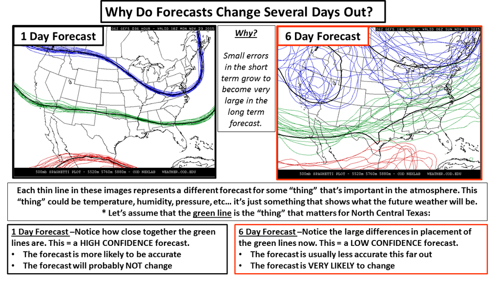
sometimes in these 7-day rainfall forecasts. The storm systems (thee are
multiples) responsible as we go out 5-7 days are often not even over land yet,
being over the ocean where the atmosphere is not as sampled as good by
instruments. So the closer we get, the better the forecasts.
Remember this graphic?
https://ticker.mesonet.org/archive/20151123/forecasting-chaos.png
That gives a pretty good explanation why. Well, we ARE seeing something of a
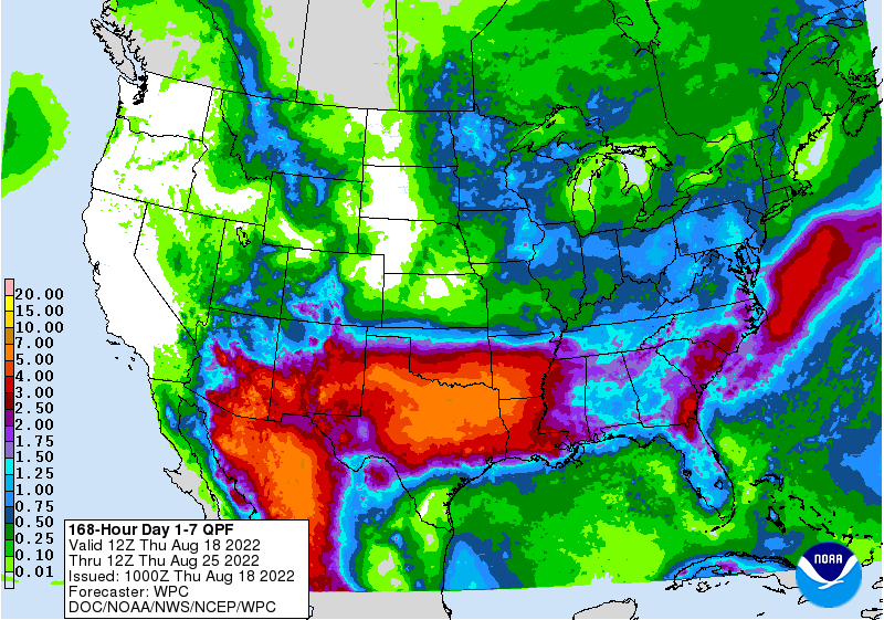
southern shift. The heaviest rains are now shifted down into Texas.
https://ticker.mesonet.org/archive/20220818/7day-rain-forecast.gif
Don't fret just yet! No, that's not the beginning of a haiku, just wanted you
to notice that most of Oklahoma is still forecast to get a good 3-5 inches over
the next 7 days. Barring any further southern shift. And the outlooks for that
last week of August are still looking on the mild and wet side.
https://ticker.mesonet.org/archive/20220818/aug25-31-outlooks.png
We have 59% of the state currently in at least Extreme (D3) drought, a level
we haven't seen in the state since May 20, 2014. If we don't want to keep
traveling backwards into the depths of that 2011-12 drought period, we need
the next 2 weeks worth of moisture forecasts to come true.
Hmmmm, maybe if I eat 50 eggs...
Gary McManus
State Climatologist
Oklahoma Mesonet
Oklahoma Climatological Survey
gmcmanus@mesonet.org
==================================================
The OCS/Mesonet Ticker
https://ticker.mesonet.org/
To subscribe or unsubscribe from the Ticker
or for questions about the Ticker or its content
Phone or Email the Ticker Manager at OCS
Phone: 405-325-2253 Email: ticker@mesonet.org
---------------------------------------------------
-C- Copyright 2024 Oklahoma Climatological Survey
===================================================
|


 Tweet
Tweet