MESONET TICKER ... MESONET TICKER ... MESONET TICKER ... MESONET TICKER ...
August 11, 2011 August 11, 2011 August 11, 2011 August 11, 2011
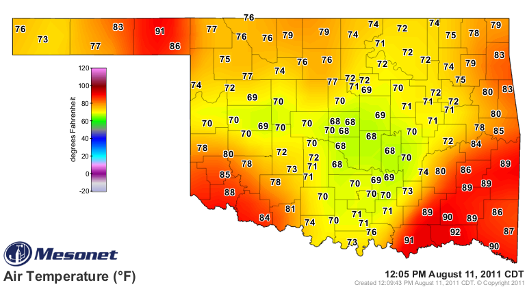
This is the first day of the rest of our drought ...
and always remember that it started cool and rainy for a lot of you. It's 68
degrees at noon here in Norman, a temperature this city hasn't seen since June
23rd, when it got down to 67 degrees. Incredible!!
http://ticker.mesonet.org/archive/20110811/current.TAIR.grad.png
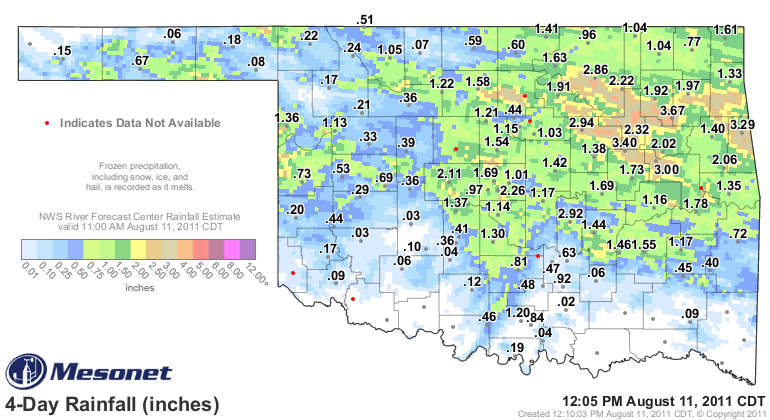
Some great rains over the last few days, especially over in northeastern
Oklahoma where radar estimates show widespread 3-4 inch amounts. Here's the
four day total map fromm the Mesonet. Notice that much of western and southern
Oklahoma remain quite dry.
http://ticker.mesonet.org/archive/20110811/rainrfc.96hr.png
Tulsa set a record for August 10th with 3.44 inches of rain, the most on that
date for them since 2.19 inches fell in 1979. Here are the top 20 totals from
the Mesonet since Monday (with rain still falling):
Inola 3.67" Cookson 2.06"
Hectorville 3.40" Pryor 1.97"
Westville 3.29" Claremore 1.92"
Oilton 2.95" Pawnee 1.88"
Wynona 2.86" Stigler 1.78"
Haskell 2.46" Red Rock 1.76"
Bixby 2.31" Kingfisher 1.75"
Skiatook 2.22" Webbers Falls 1.71"
El Reno 2.10" Porter 1.70"
OKC East 2.10" OKC North 1.67"
Those are some AWESOME rainfall totals, more than some areas have seen for
months. Texas County in the Panhandle has seen 1-3 inches for the entire year,
to put it in perspective. In eastern Oklahoma, they are a great start to true
drought relief. In western and central Oklahoma, they are an okay start. However,
we now need to start earning interest on our capital. More rains are needed
over the next few days in case the bottom drops out once again, and those rains
need to be more widespread (hey to southern Oklahoma).
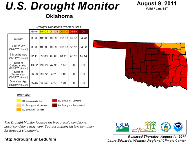
The latest U.S. Drought Monitor reflects conditions through Tuesday at 7 a.m.
so no changes due to rain, if it would be necessary, would show up on this
map anyway. There was a bit of drawback of the D4 in Cimarron County in the
Panhandle but a progression to the east.
http://ticker.mesonet.org/archive/20110811/ok_dm.png
That leaves 93% of the state in either D3-D4 status. It's difficult to think
drought during rain, but I urge you to remember that the antecedent conditions
remain for those areas that are getting hefty totals for a quick return to
severe impacts. For those that aren't so lucky so far, those severe impacts
remain in full force.
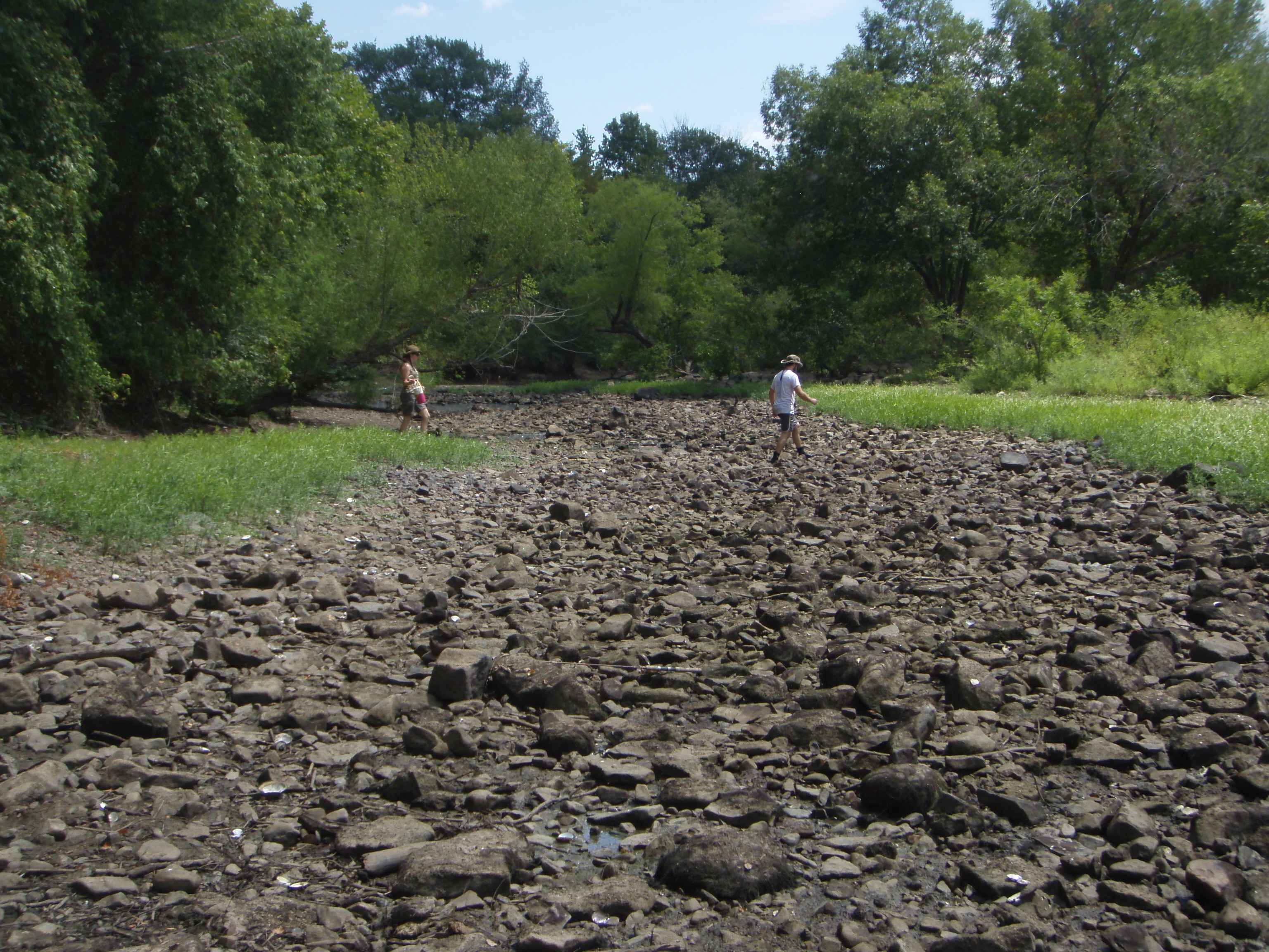
We have had reports from the Oklahoma Biological Survey that some rivers in
southeastern Oklahoma are in extremely bad shape with mussel beds exposed to
the air. From their reports, they had not seen that in the last 20 years of
observations. The water temperatures in some areas were 104 degrees. Here's a
picture from the Kiamichi River in Pushmataha County.
http://ticker.mesonet.org/archive/20110811/driedmusselbed1.jpg
So it's not just wheat, cotton and cattle being affected by this drought. There
are serious concerns over many areas of the state that we probably don't even
realize yet.
Bring on the rain! We'll take it.
Gary McManus
Associate State Climatologist
Oklahoma Climatological Survey
(405) 325-2253
gmcmanus@mesonet.org
==================================================
The OCS/Mesonet Ticker
https://ticker.mesonet.org/
To subscribe or unsubscribe from the Ticker
or for questions about the Ticker or its content
Phone or Email the Ticker Manager at OCS
Phone: 405-325-2253 Email: ticker@mesonet.org
---------------------------------------------------
-C- Copyright 2024 Oklahoma Climatological Survey
===================================================
|


 Tweet
Tweet