MESONET TICKER ... MESONET TICKER ... MESONET TICKER ... MESONET TICKER ...
August 9, 2018 August 9, 2018 August 9, 2018 August 9, 2018
Drought Impossible
Mother Nature's mission, should she choose to accept it, is to relieve the
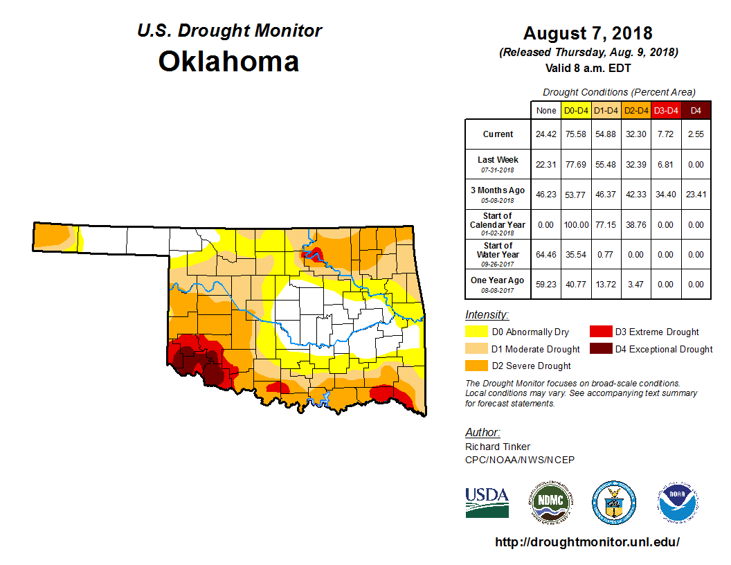
EXCEPTIONAL DROUGHT introduced this week across much of far SW OK.
http://ticker.mesonet.org/archive/20180809/20180807_OK_trd.png
The D4 drought intensity showing up this week is the first substantial amount in
the state since mid-June. Now it's only a tiny amount, but it's concentrated in
one area, signalling misery for ag producers in that corner. Notice we also have
a new area of Extreme (D3) drought in the Osage/Pawnee/Noble county area, with
more tales of woe coming from that region.
So you have extreme/exceptional drought, it's August, you think you're hosed
by the Syndicate...errrr, I mean "summer," correct? Well no! In this case, we're
headed towards another August 2017 it would appear, with lost of below normal
temperatures and above normal precipitation. In fact, thanks to a cut-off upper-
level low pressure system likely to form in the TX Panhandle, relief for SW OK
is possible as early as THIS WEEKEND. A cut-off low is often known as
"meteorologist's woe" since it's not being steered by any sort of atmospheric
flow. So as it meanders around, it can often move erratically. But as it bounces
slowly around like a drunken junebug, it will be able to tap into deep, Gulf
moisture and pump it up over Oklahoma. All you need are a few storm triggers and
vwalla (I can't spell voilŕ), you have heavy rains, clouds and very non-August
temperatures.
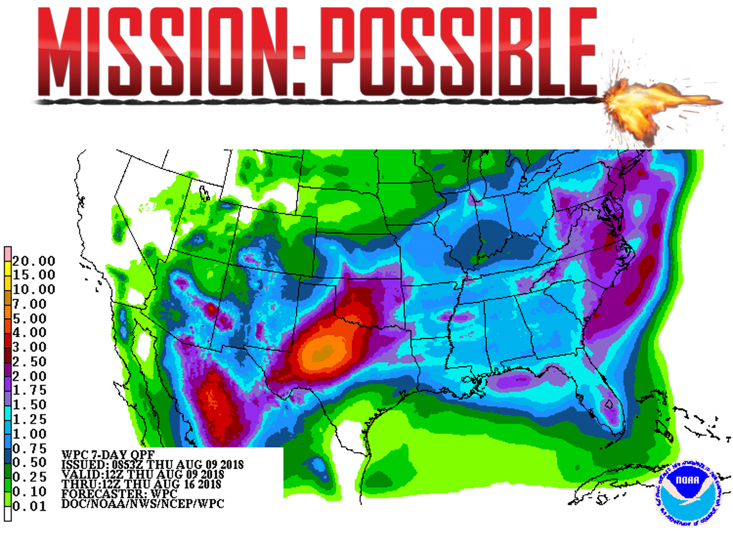
So, yes, Mission POSSIBLE!
http://ticker.mesonet.org/archive/20180809/drought-relief-possible.png
Wait wait wait, remember, this is a forecast, and there is a reason a cut-off
low is a meteorologist's woe. But the odds are pretty good we'll see significant
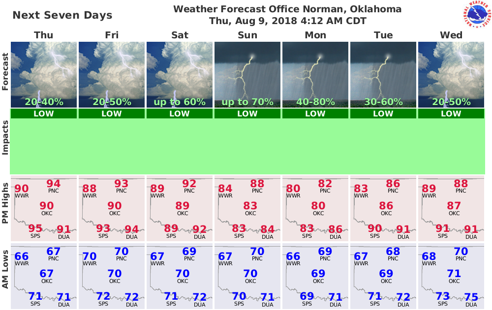
rains in the state over the weekend into early next week. Our NWS friends think
so.
http://ticker.mesonet.org/archive/20180809/nws-norman-7day-forecast.png
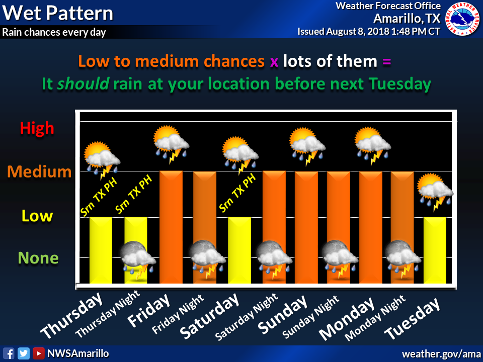
http://ticker.mesonet.org/archive/20180809/nws-amarillo-panhandle-rain.png
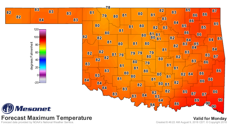
The temperature forecasts think so.
http://ticker.mesonet.org/archive/20180809/sunday-forecast-highs.png
http://ticker.mesonet.org/archive/20180809/monday-forecast-highs.png
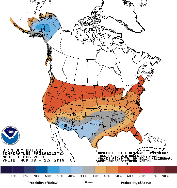
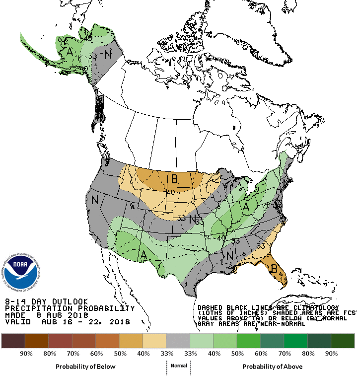
And the outlooks think it'll continue even after early next week.
http://ticker.mesonet.org/archive/20180809/aug16-22-temp-outlook.gif
http://ticker.mesonet.org/archive/20180809/aug16-22-precip-outlook.gif
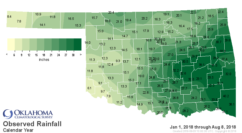
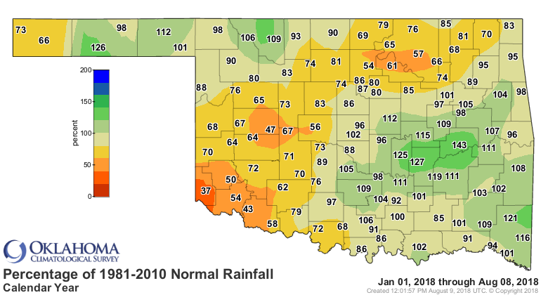
It's gonna take a bit of work. SW OK and other parts of the state have a long
way to go in 2018 to catch up to normal.
http://ticker.mesonet.org/archive/20180809/year-to-date-rain.totals.png
http://ticker.mesonet.org/archive/20180809/ytd-rain-departures.png
http://ticker.mesonet.org/archive/20180809/ytd-rain-pct-normal.png
Probably won't get there with these rains. That's okay, I've been trying to
reach normal for years and I'm still not there. But, these rains are a start.
For SW Oklahoma, not me. That's definitely Mission IMPOSSIBLE.
Gary McManus
State Climatologist
Oklahoma Mesonet
Oklahoma Climatological Survey
(405) 325-2253
gmcmanus@mesonet.org
==================================================
The OCS/Mesonet Ticker
https://ticker.mesonet.org/
To subscribe or unsubscribe from the Ticker
or for questions about the Ticker or its content
Phone or Email the Ticker Manager at OCS
Phone: 405-325-2253 Email: ticker@mesonet.org
---------------------------------------------------
-C- Copyright 2024 Oklahoma Climatological Survey
===================================================
|


 Tweet
Tweet