MESONET TICKER ... MESONET TICKER ... MESONET TICKER ... MESONET TICKER ...
July 20, 2022 July 20, 2022 July 20, 2022 July 20, 2022
Can ya wait a bit?
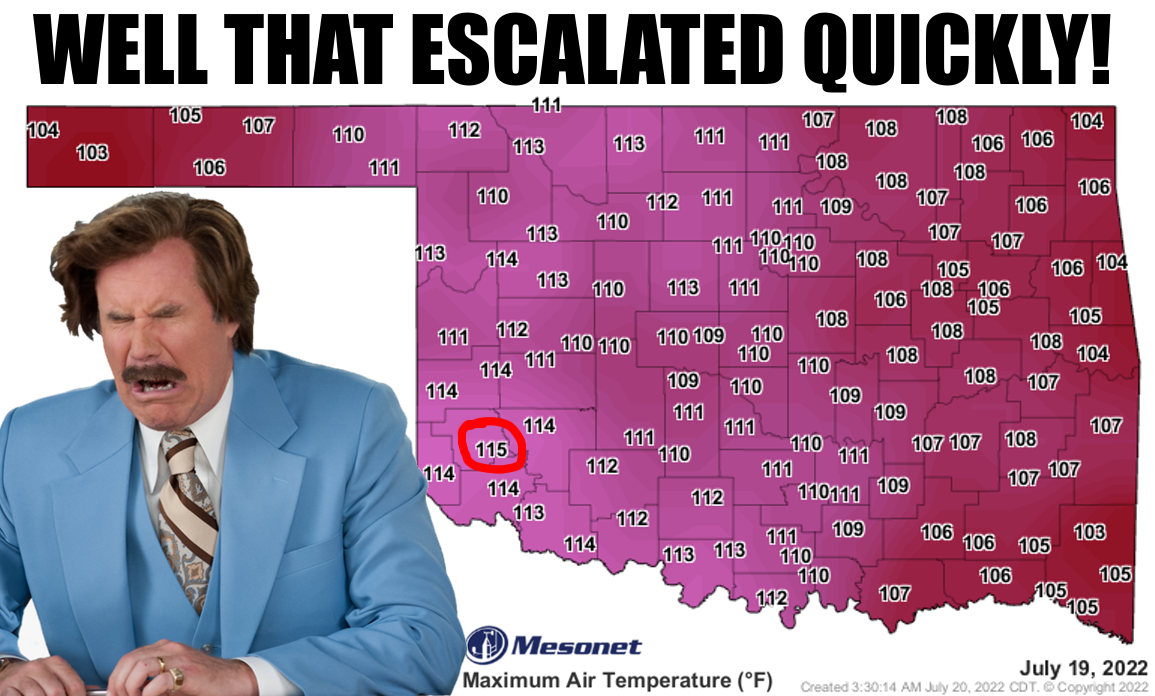
https://ticker.mesonet.org/archive/20220720/yesterdays-highs.png
Did it though? That somewhat historic day of heat yesterday had been building for
the last 40 days after the rains turned off on June 11 and summer decided to
become brutal. With the drought/sun sensible heat feedback loop fully activated,
we just needed the right conditions to produce a day like yesterday.
Here are some of the high(low)lights from yesterday (and today):
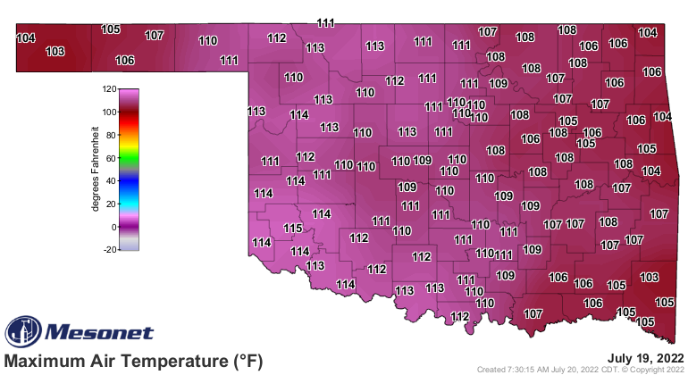
1. The 115 at Mangum ties for the highest temperature ever recorded by the
Mesonet with six other readings. Now when you get down to the decimal points to
get a bit of separation, it breaks down like this.
Buffalo 115.2 July 9, 2009
Kingfisher 115.0 Aug. 1, 2012
Wilburton 115.0 Aug. 3, 2011
Hollis 115.0 June 26, 2011
Mangum 114.8 July 19, 2022
Wister 114.6 Aug. 3, 2011
Erick 114.6 June 26, 2011
2. It was the third time all 120 Mesonet sites had reached triple-digits in
a single day (although there were a couple other times when it was likely but
a missing obs at a station precludes us from including those days), but the
first time in Mesonet history that all 120 reached 103 degrees.
Those other days above 100 degrees were 7/9/11 and 7/10/11.
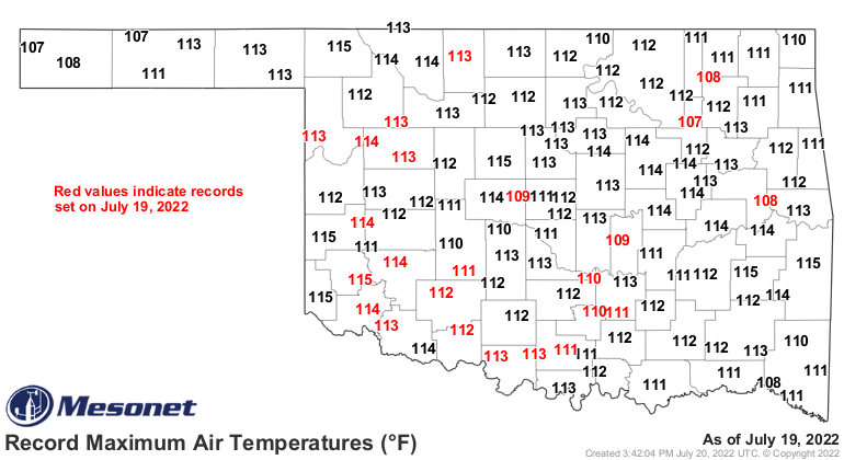
3. Preliminary data show that 24 Mesonet sites hit their all-time high
temperatures yesterday. There are some newer stations in there (Talala, Tulsa
North, Webbers Falls, Seminole, Yukon, Newport), but that leaves 18 longer-term
stations that broke their records.
https://ticker.mesonet.org/archive/20220720/mesonet-alltime-highs-july19.png
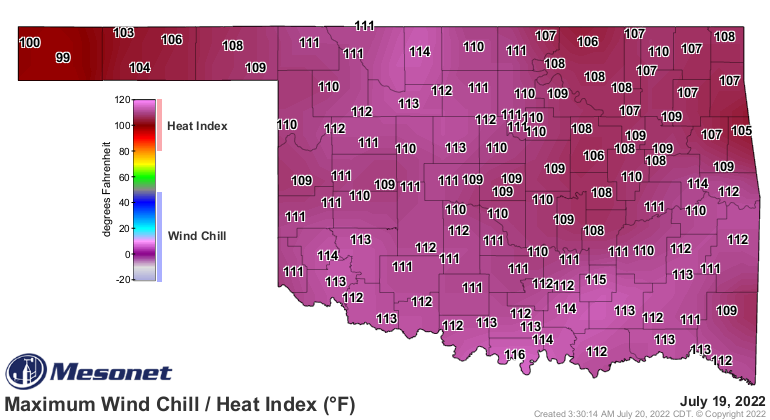
4. The heat index values, while not record-setting, were still significant.
However, the day could probably still be qualified by "it's a dry heat."
https://ticker.mesonet.org/archive/20220720/yesterdays-high-heat.index.png
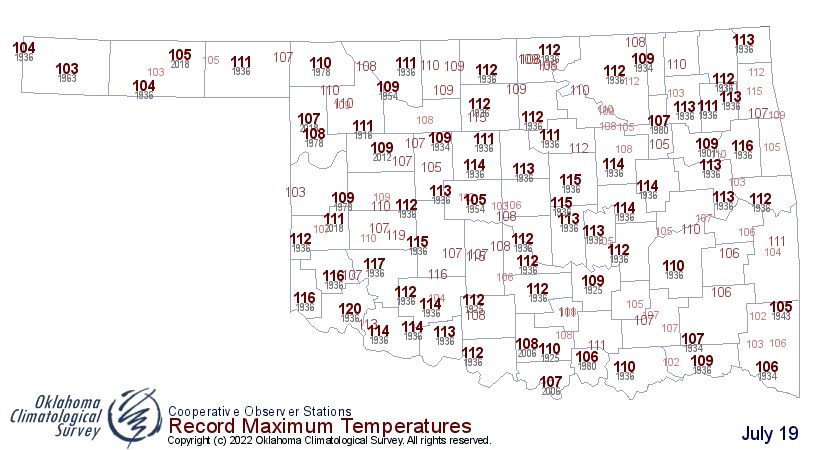
5. While it takes a lot to break an all-time daily temperature record in July
when comparing to the long-term data, I think we certainly saw our fair share
of locations with all-time highs yesterday.
https://ticker.mesonet.org/archive/20220720/july19-record-highs.png
https://ticker.mesonet.org/archive/20220720/yesterdays-high-temps.png
6. The statewide average high temperature was 109.17 degrees, third highest
the Mesonet had even seen:
Aug. 2, 2011 -- 109.98F
Aug. 1, 2012 -- 109.90F
July 19, 2022 - 109.17F
Aug. 5, 2011 -- 108.95F
Aug. 2, 2012 -- 108.82F
Again showing it doesn't pay to hang out with the summers of 2011-12.
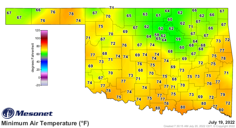
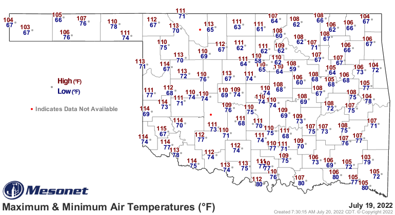
7. The statewide AVERAGE temperature (taking all the highs and lows together)
yesterday was 89.9 degrees, which is only good enough to tie for the 35th
warmest day in Mesonet history. Aug. 2, 2011, has the top spot at 94.5F. The
problem (and it WASN'T a problem) was the low temperatures were quite mild for
a huge heat day like yesterday. Lake Carl Blackwell, for example, went from a
low of 58 degrees to a high of 110 degrees, 52 degrees difference!
Top spot all-time, dating back to the 1880s...Aug. 12, 1936, at 94.9 degrees.
https://ticker.mesonet.org/archive/20220720/yesterdays-lows.png
https://ticker.mesonet.org/archive/20220720/yesterday.hilo.gif
BRIEF INTERLUDE
I've done so much data mining late into the night and starting again early
this morning I'm losing track. And if you lose your track whilst mining, well,
it can lead to a cave in, or a fun-filled adventure escaping from Orcs! We'll
go with the Orc adventure here.
LIGHTS BLINKING, INTERLUDE OVER
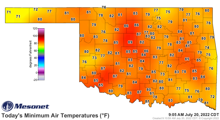
8. Still working on this one, but it would appear Kingfisher has tied the Mesonet's
all-time highest minimum temperature at 89 degrees this morning. Now for the
caveats...if Stillwater drops below 89 degrees by midnight, that fouls the
statistics and we don't tie the record. It could be a close one. I'm still
confirming that Stillwater has that record from back on Aug. 2, 2012. All-time
highest minimum temperature in the longer-term records is Wewoka's 94 degrees
back on Aug. 3, 1943.
https://ticker.mesonet.org/archive/20220720/todays-lows.png
9. 61 Mesonet sites hit at least 110 degrees yesterday, unbelievably not even
in the top 5. The top spot goes to 8/2/2011 (OF COURSE!!) with 87 stations.
10. 109 Mesonet sites hit at least 105 degrees, which ties yesterday with
Aug. 1, 2012, and Aug. 5, 2011, for third spot all-time in Mesonet history.
Aug. 2, 2011 115 sites
Aug. 1, 2011 113 sites
Aug. 1, 2012 109 sites
Aug. 5, 2011 109 sites
July 19, 2022 109 sites
HA! TAKE THAT 2011 AND 2012! You can't keep yesterday out of those top-fives
completely.
I think we've adequately shown that yesterday at least belongs in the same
conversation with some of those legendary hot days in Mesonet history. If not
in the same convo, then at least it's a whisper close by. As we've said many
times, the hottest day in Oklahoma since 2012.
Today will again be hot, but not near-historic like yesterday. drop temps down
about 5 degrees, maybe? We'll see. And heat index values might be a bit higher.
We are starting out well above where we were yesterday. In fact, the 79 sites
that had a low of 80 degrees or higher as of this morning (again, could change
by midnight) would easily be the highest in mesonet history, beating out
7/27/2011's 70 sites. The 20 sites with lows at 85 or above also beats out
8/2/2012's 13. We'll see where we end up tonight.
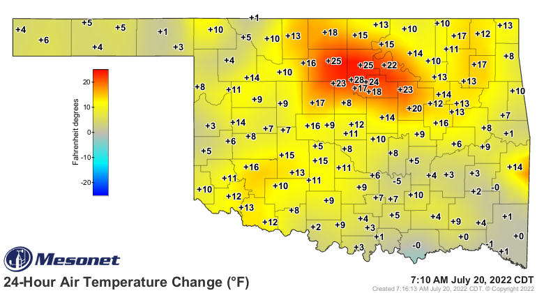
https://ticker.mesonet.org/archive/20220720/24hour-temp-change.png
With that head start, a few spots might beat out yesterday's highs, but the
intense heat probably not as prevalent.
https://ticker.mesonet.org/archive/20220720/latest.oklahoma.heat.gif
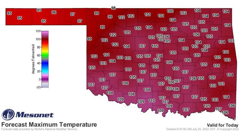
https://ticker.mesonet.org/archive/20220720/todays-forecast-highs.png
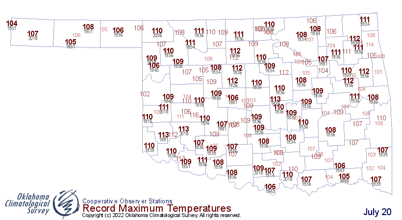
https://ticker.mesonet.org/archive/20220720/july20-hi-tmax-records.png
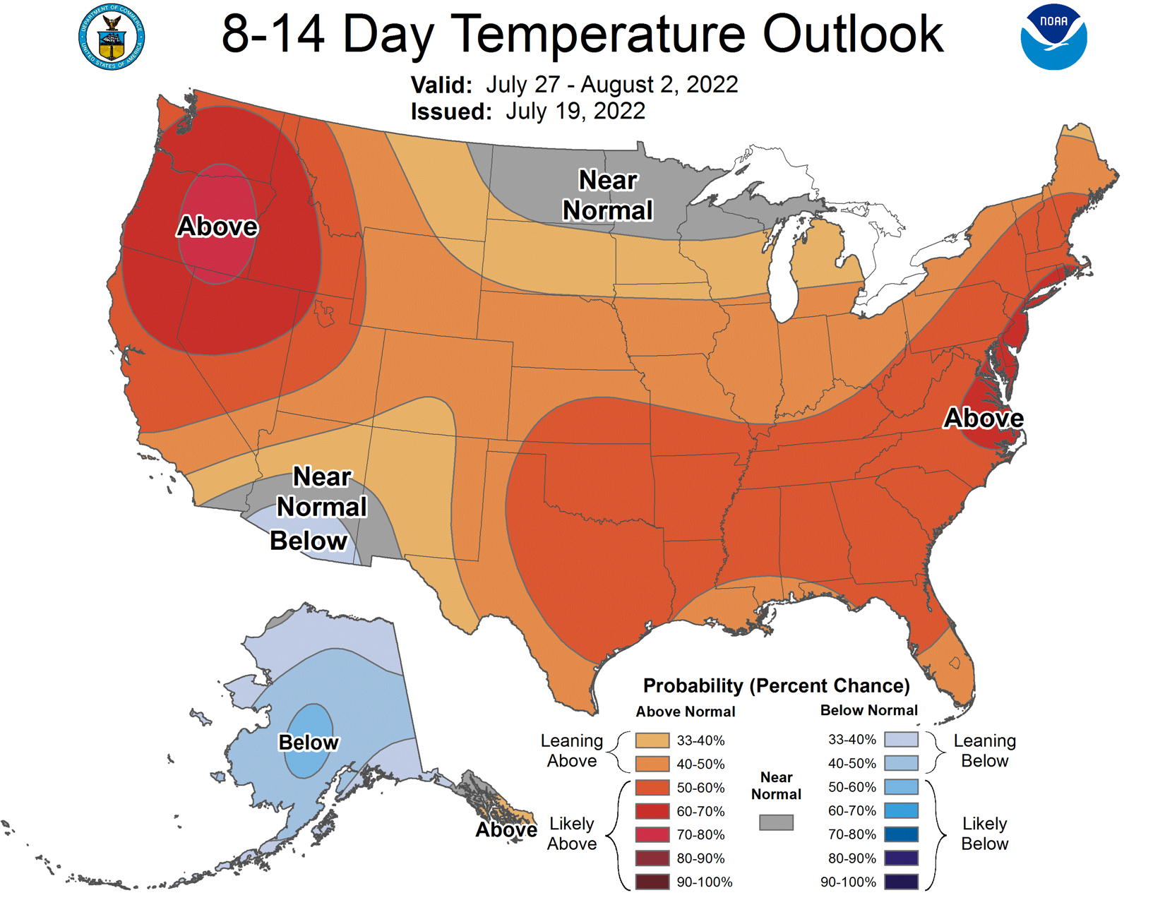
Still looking at another week at least of heat, but maybe a break down into
the 90s when we get to August? The outlooks for then do show possibly a bit
less of an above normal signal.
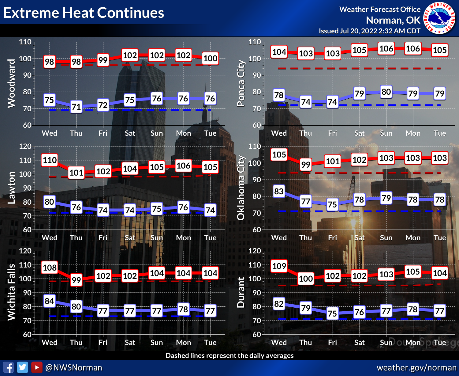
https://ticker.mesonet.org/archive/20220720/nws-norman-7day-temps.png
https://ticker.mesonet.org/archive/20220720/july27-aug2-temp-outlook.png
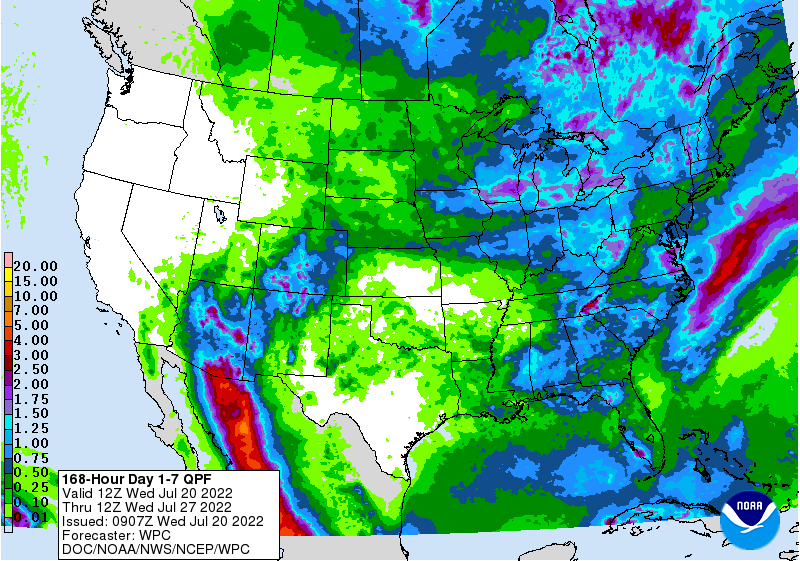
Rain? HA!
https://ticker.mesonet.org/archive/20220720/7day-rain-forecast.gif
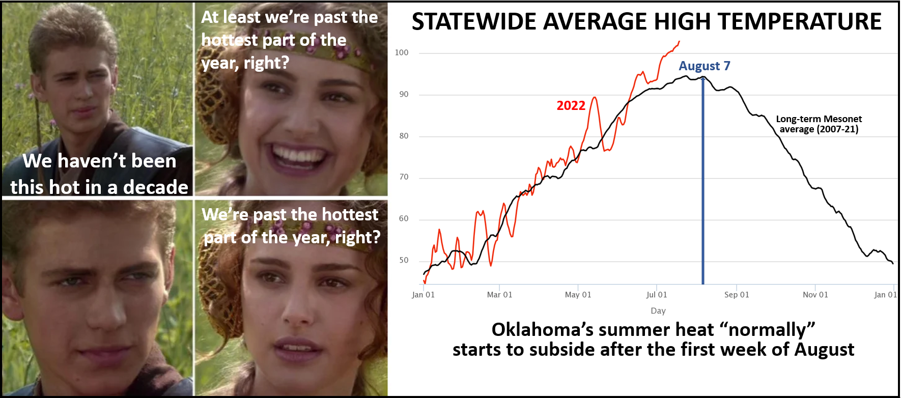
Now let's all cry along with Padme. We still have about 3 weeks to go in our
NORMAL trek to the hottest part of the year. After that, it's NORMALLY all
down hill.
https://ticker.mesonet.org/archive/20220720/statewide-avg-highs-average.png
Now when has Oklahoma been "normal?"
Gary McManus
State Climatologist
Oklahoma Mesonet
Oklahoma Climatological Survey
gmcmanus@mesonet.org
==================================================
The OCS/Mesonet Ticker
https://ticker.mesonet.org/
To subscribe or unsubscribe from the Ticker
or for questions about the Ticker or its content
Phone or Email the Ticker Manager at OCS
Phone: 405-325-2253 Email: ticker@mesonet.org
---------------------------------------------------
-C- Copyright 2024 Oklahoma Climatological Survey
===================================================
|


 Tweet
Tweet