MESONET TICKER ... MESONET TICKER ... MESONET TICKER ... MESONET TICKER ...
July 21, 2022 July 21, 2022 July 21, 2022 July 21, 2022
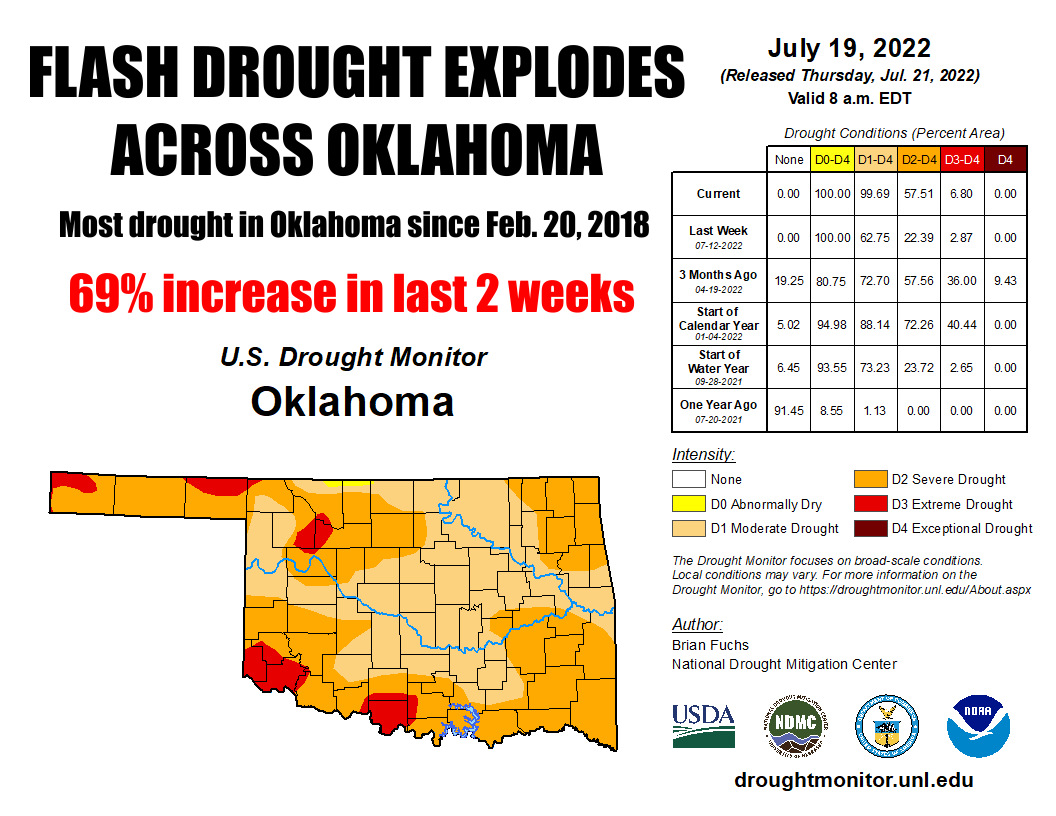
Drought explosion!
https://ticker.mesonet.org/archive/20220721/20220719_ok_trd.png
Boom indeed. Fueled by both a dry AND a heat spell that began June 11, drought
has rapidly expanded across the state of Oklahoma and the region in the last three
weeks. The combination of heat and dry weather, prime ingredients for flash drought
in the warm season, with added help from an abundance of the summer sun, has
brought us back to levels of drought not seen in the state in over four years.
You have to go back to Feb. 20, 2018, to find the last U.S. Drought Monitor map
that had virtually the entire state in at least D1 (Moderate) drought.
https://ticker.mesonet.org/archive/20220721/2022-vs-2018-drought.PNG
That drought was just getting ramped up, an ominous sign for our current flash
drought, which could continue to intensify and spread and end up a longer-term
drought episode. Much of the region is suffering the same fate, as evidenced by the
4-week change map from the U.S. Drought Monitor. Portions of the area that don't
show large increases are still mired in long-term drought with origins back to
late August 2021, including much of western Oklahoma.
https://ticker.mesonet.org/archive/20220721/4week-change-DM.png
The current flash drought episode (and the longer-term drought's persistence)
is fueled by that dearth of rainfall and abundance of heat that began some 40
days ago. We are still showing that period to be the driest such span in the
last 100 years, a statistic that continues to hold firm with each additional
day.
https://ticker.mesonet.org/archive/20220721/june11-july21-rain-totals.png
https://ticker.mesonet.org/archive/20220721/june11-july21-departure.png
https://ticker.mesonet.org/archive/20220721/june11-july21-pct-normal.png
https://ticker.mesonet.org/archive/20220721/june11-july21-stats.png
https://ticker.mesonet.org/archive/20220721/mesonet.rainfall.tenthinch.png
https://ticker.mesonet.org/archive/20220721/mesonet.rainfall.quarterinch.png
Mesonet statewide average graphs of long-term average (2007-2021) data vs. 2022
shows the magnitude of the temperature, pct. of possible sunshine, and resulting
evaporation anomalies, to go along with that record dryness.
https://ticker.mesonet.org/archive/20220721/statewide-avg-temp.png
https://ticker.mesonet.org/archive/20220721/statewide-avg-pct.sunshine.png
https://ticker.mesonet.org/archive/20220721/statewide-avg-evaporation.png
So that's a whole lot of bad news, right? Well, maybe there's some good news
down the line? Some of the forecast models are showing a pattern change as we
get later into next week to end July and begin August. Maybe a flattening of that
heat dome which could allow for a front or two, and additional rainfall chances.
https://ticker.mesonet.org/archive/20220721/july26-30-precip-outlook.png
Now here's the trick, however. That shows increased odds of above normal
rainfall (pretty sure it won't be snow, but it IS Oklahoma, after all), but we
also have to remember this is one of the driest parts of the warm season. So
what would "above normal" mean in this case? Well, we know it's better than what
we've been getting, at least for most of the state. But it HAS rained in the last
few days, and there is a chance of showers and storms in the state today and
tomorrow thanks to a fading frontal boundary (and we all know just how painful
that can be) hanging out in the area. And then we see a bit of those increased
rain odds next week starting to show up on the7-day rainfall map.
https://ticker.mesonet.org/archive/20220721/2day-rainfall.png
https://ticker.mesonet.org/archive/20220721/7day-rain-forecast.gif
BUT WAIT! I can't let you get away without dampening (ba dum bum!) your hopes
just a bit. Well, it's not ME doing it, it's Mother Nature. The CPC outlooks
for both August and the August-October periods show rather depressing fortunes
for Oklahoma and its drought situation. Both periods see increased odds of
above normal temperatures and below normal precipitation across most of the
state, and then for that August-October period...drought persistence or
intensification.
https://ticker.mesonet.org/archive/20220721/august-temp-outlook.png
https://ticker.mesonet.org/archive/20220721/august-precip-outlook.png
https://ticker.mesonet.org/archive/20220721/aug-oct-temp-outlook.png
https://ticker.mesonet.org/archive/20220721/aug-oct-precip-outlook.png
https://ticker.mesonet.org/archive/20220721/aug-oct-drought-outlook.png
But hey, those don't have to come true, right? The cautionary tale here is
that a third straight cool season with La Nina is looking more and more likely,
so as we get into October and November, we could see an impact from that
sea surface temperature and atmospheric wind pattern anomaly in the form of
warmer and drier weather from the mid-fall period through next spring.
Heck, we need to get past the next seven days, though, which look hot! And with
that chance of rain today comes higher humidity and more high heat warnings.
https://ticker.mesonet.org/archive/20220721/current-dewpoints.png
https://ticker.mesonet.org/archive/20220721/latest.oklahoma.heat.gif
Oh yeah, our Mesonet-era tying minimum temperature from Kingfisher yesterday
of 89 degrees didn't make it through the evening. Kingfisher dropped to 85
degrees before midnight.
https://ticker.mesonet.org/archive/20220721/yesterdays-lows.png
Oh well, you lose some, you lose some (not much winning going on right now).
The heat continues for another week at least...then, we'll see.
https://ticker.mesonet.org/archive/20220721/nws-norman-7day-temps.png
Gary McManus
State Climatologist
Oklahoma Mesonet
Oklahoma Climatological Survey
gmcmanus@mesonet.org
==================================================
The OCS/Mesonet Ticker
https://ticker.mesonet.org/
To subscribe or unsubscribe from the Ticker
or for questions about the Ticker or its content
Phone or Email the Ticker Manager at OCS
Phone: 405-325-2253 Email: ticker@mesonet.org
---------------------------------------------------
-C- Copyright 2024 Oklahoma Climatological Survey
===================================================
|


 Tweet
Tweet