MESONET TICKER ... MESONET TICKER ... MESONET TICKER ... MESONET TICKER ...
July 18, 2022 July 18, 2022 July 18, 2022 July 18, 2022
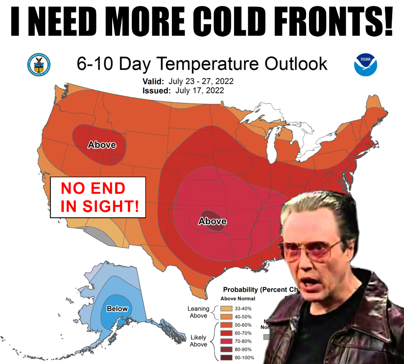
How high?
https://ticker.mesonet.org/archive/20220718/july23-27-temp-outlook.png
Speaking of cold fronts, enjoy that one today as it should drop most of the state
into the (checks notes) high 90s and low 100s! WOW! What a gift, right? And as
with the past cold fronts, only those across the northern half of the state see
any sort of relatively milder air as the southern counties continue to bake. But
maybe (and that's a big maybe, and even bigger but...badum dum!) it will keep us
all below record levels for today.
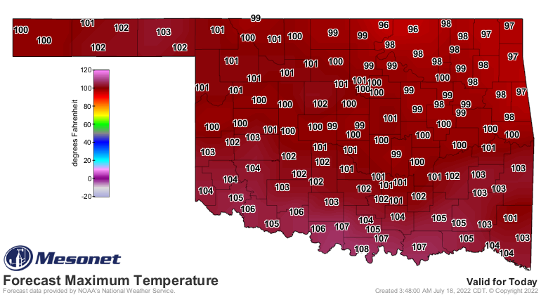
https://ticker.mesonet.org/archive/20220718/todays-forecast-highs.png
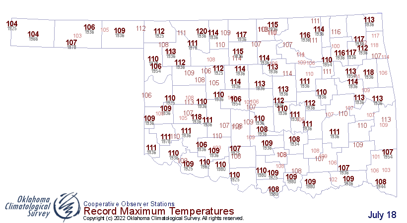
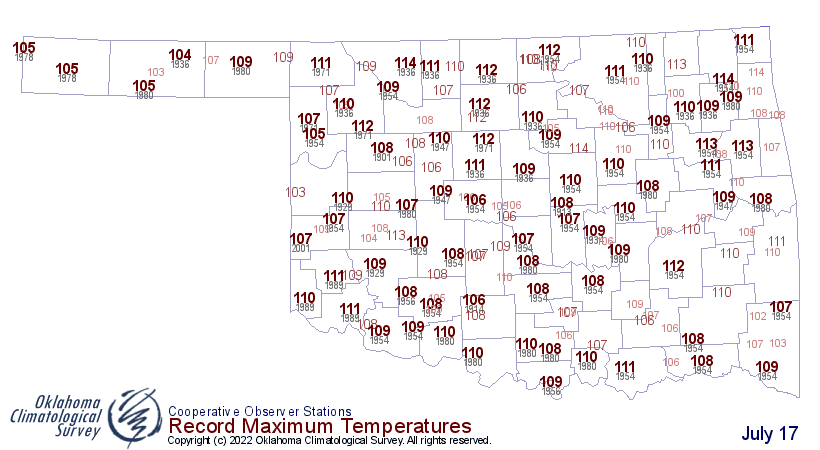
https://ticker.mesonet.org/archive/20220718/july18-high.temp-records.png
That certainly isn't the case over the last few days as somebody in the state has
seen a record high daily temperature record.
https://ticker.mesonet.org/archive/20220718/saturdays-highs.png
https://ticker.mesonet.org/archive/20220718/july16-high.temp-records.png
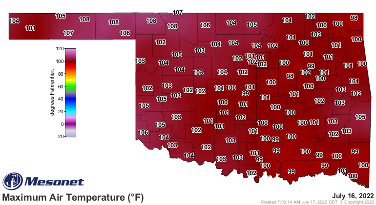
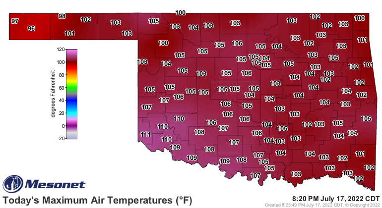
https://ticker.mesonet.org/archive/20220718/yesterdays-highs.png
https://ticker.mesonet.org/archive/20220718/july17-high.temp-records.png
So a cooler (go ahead, give us a good "GUFFAW") day today will allow all eyes
to focus on tomorrow and Wednesday, but tomorrow in particular as we could see
the highest temps in the state since 2011 and 2012. Highs across western Oklahoma
will be pushing that 115 barrier, which would put it up there with the highest
temperatures ever recorded by the Mesonet. And Wednesday is no slouch either, but
Tuesday in particular looks brutal
https://ticker.mesonet.org/archive/20220718/tues-forecast-highs.png
https://ticker.mesonet.org/archive/20220718/wed-forecast-highs.png
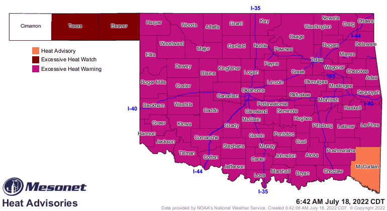
Those ridiculous temps tomorrow have earned almost the entire state an "excessive
heat warning" for heat index values up also in the 110-115 range.
https://ticker.mesonet.org/archive/20220718/latest.oklahoma.heat.gif
As for actual air temperature values we're looking at eclipsing, keep these
readings in mind:
Last 113: July 14, 2020 at Hollis Mesonet
Last 114: Aug. 4, 2012 at Ralston NWS COOP
Last 115: Aug. 1, 2012 at Kingfisher Mesonet
Last 116: July 6, 1996 at Ponca City Airport
Last 117: July 3, 1980 at Mangum NWS COOP
Last 118: July 18, 1954 at Jay NWS COOP
Last 119: July 19, 1936 at Cloud Chief NWS COOP
Last 120: Aug. 12, 1936 at Altus NWS COOP
Last 121: NOT IN OK RECORDED DATA
Okay, so do we REALLY need to worry about those last few? Probably not. But
we could definitely see that 114 or 115 mark threatened. And the days where we
get up in that range are beyond rare. We've seen 114 degrees or higher on 122
days since the mid-1890s...that's 122 days out of the last 692,000 or so. And
only 29 days since 1987.
So if you had a dollar for every day since 1896 without a reading of 114 degrees
or higher, you'd have just about $692,000. Adjusting for inflation that's about
ONE HUNDRED BILLION DOLLARS (do Dr. Evil smirk with pinky to mouth)! Well, maybe
not that much, but I'm not doing the math.
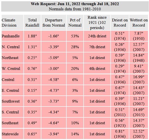
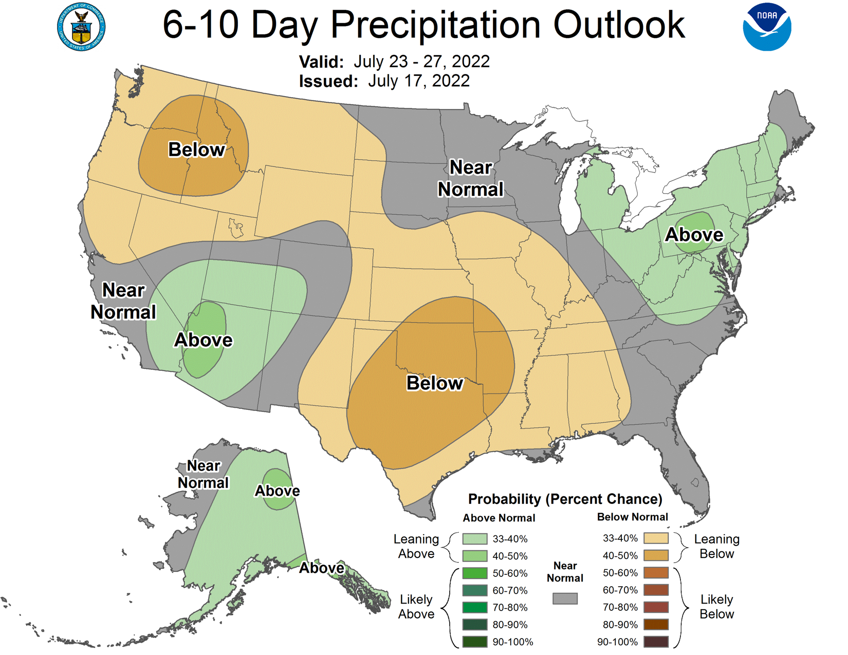
As for rain? Well, the only marks threatened there are the dry ones, as we
continue with our driest running June 11-forward period in the last 100 years.
I hope I said that correctly. Basically, starting with June 11 as we add each
day, THAT new period is the driest such period in the last 100 years...at least
since 1921.
https://ticker.mesonet.org/archive/20220718/june11-july18-stats.png
That doesn't look to get interrupted anytime soon with a pretty dismal rain
forecast over the next week. And probably after that.
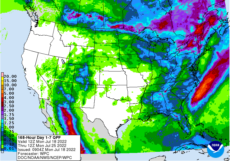
https://ticker.mesonet.org/archive/20220718/7day-rain-forecast.gif
https://ticker.mesonet.org/archive/20220718/july23-27-precip-outlook.png
It's all up to the "ARCH-DEMON DEATH RIDGE OF 2022" now (trademark pending on
that name). As it shifts away from us and back over us, it might allow a few
showers here and there, and a stray "cold" front or two. But don't get too
many hopes up just yet for short-term relief, but get tons of hope up for
the fall.
It WILL eventually get here.
Gary McManus
State Climatologist
Oklahoma Mesonet
Oklahoma Climatological Survey
gmcmanus@mesonet.org
==================================================
The OCS/Mesonet Ticker
https://ticker.mesonet.org/
To subscribe or unsubscribe from the Ticker
or for questions about the Ticker or its content
Phone or Email the Ticker Manager at OCS
Phone: 405-325-2253 Email: ticker@mesonet.org
---------------------------------------------------
-C- Copyright 2024 Oklahoma Climatological Survey
===================================================
|


 Tweet
Tweet