MESONET TICKER ... MESONET TICKER ... MESONET TICKER ... MESONET TICKER ...
July 19, 2022 July 19, 2022 July 19, 2022 July 19, 2022
How about no?
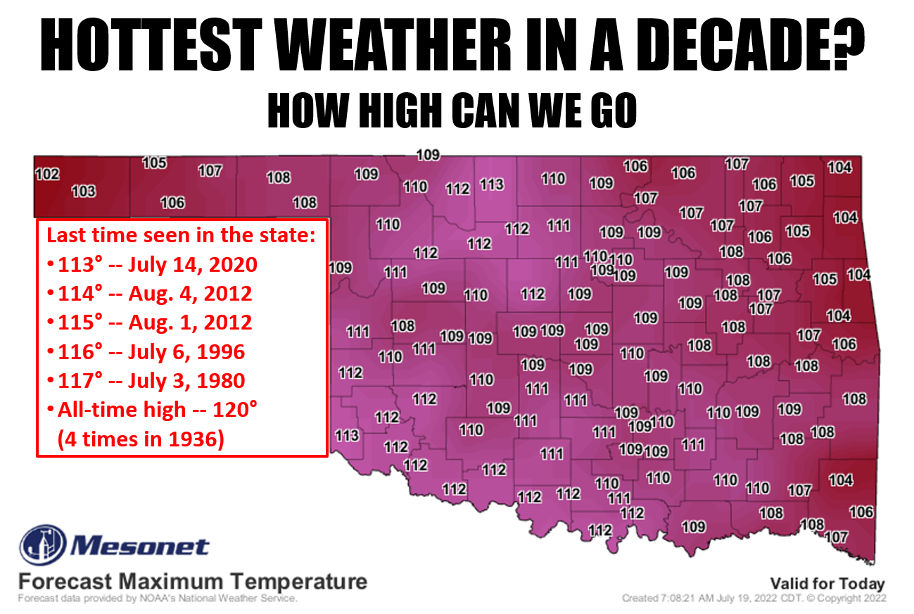
https://ticker.mesonet.org/archive/20220719/decadal-heat.png
I know the highest temperature I see on that map is 113, but you just never know
on days like this. With the proper air pattern--maybe some downslope SW winds--we
could still hit some of those higher temps that take us back to 2011 and 2012.
Not that I'm hoping for that, mind you. It would be much better to have it stay
down in the 105-110 range, realistically speaking. And that's not even discussing
the heat index, which is supposed to exceed 115 degrees in some locations. Enough
that almost the entire state is still in that excessive heat warning category.
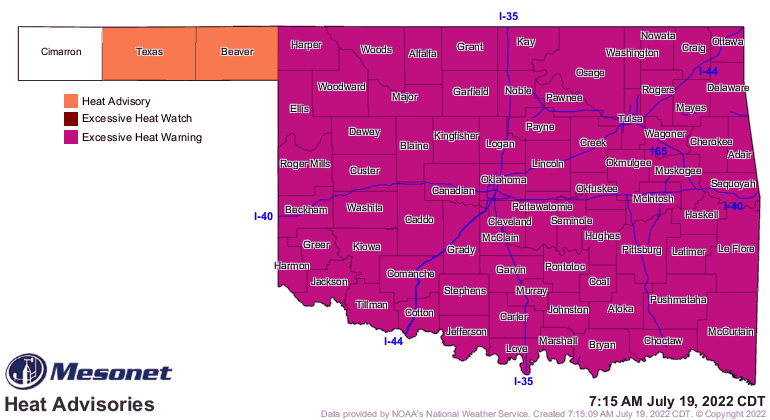
https://ticker.mesonet.org/archive/20220719/latest.oklahoma.heat.gif
It doesn't matter which category you're going to be in...it'll all get ya if you're
not careful! Of course, those most vulnerable will be in a bit more danger today,
so mind them if you can and give them a check. Oh, what else for today? How
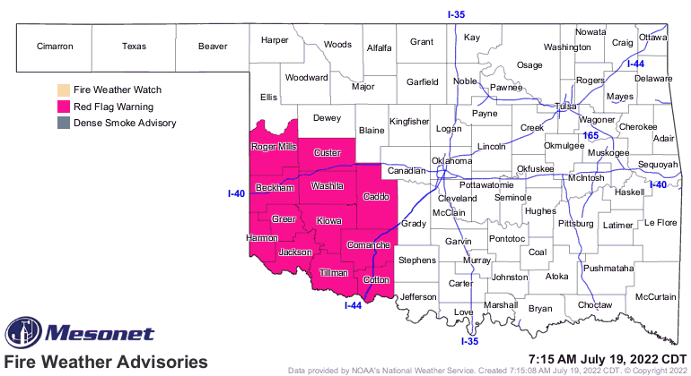
about a Red Flag Fire Warning down across SW OK due to those temps in the 110-115
range, with RH down into 15-20% territory and winds gusting to 30 mph? No. But yes,
that's what we will have. No. Sorry, that doesn't work...still gonna have those
conditions. Imagine fighting fires on a day like today? No. Yeah, I'm telling
ya that doesn't work or it would never get below 70 degrees...I've tried it.
https://ticker.mesonet.org/archive/20220719/latest.oklahoma.fire.gif
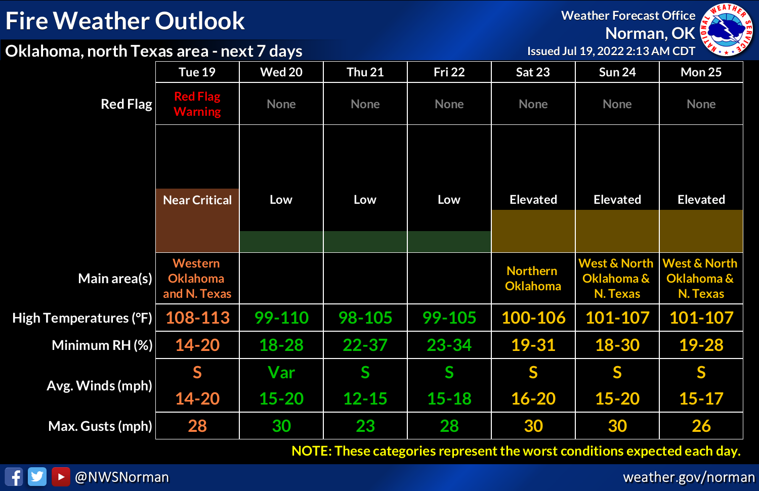
https://ticker.mesonet.org/archive/20220719/nws-norman-fire.danger.png
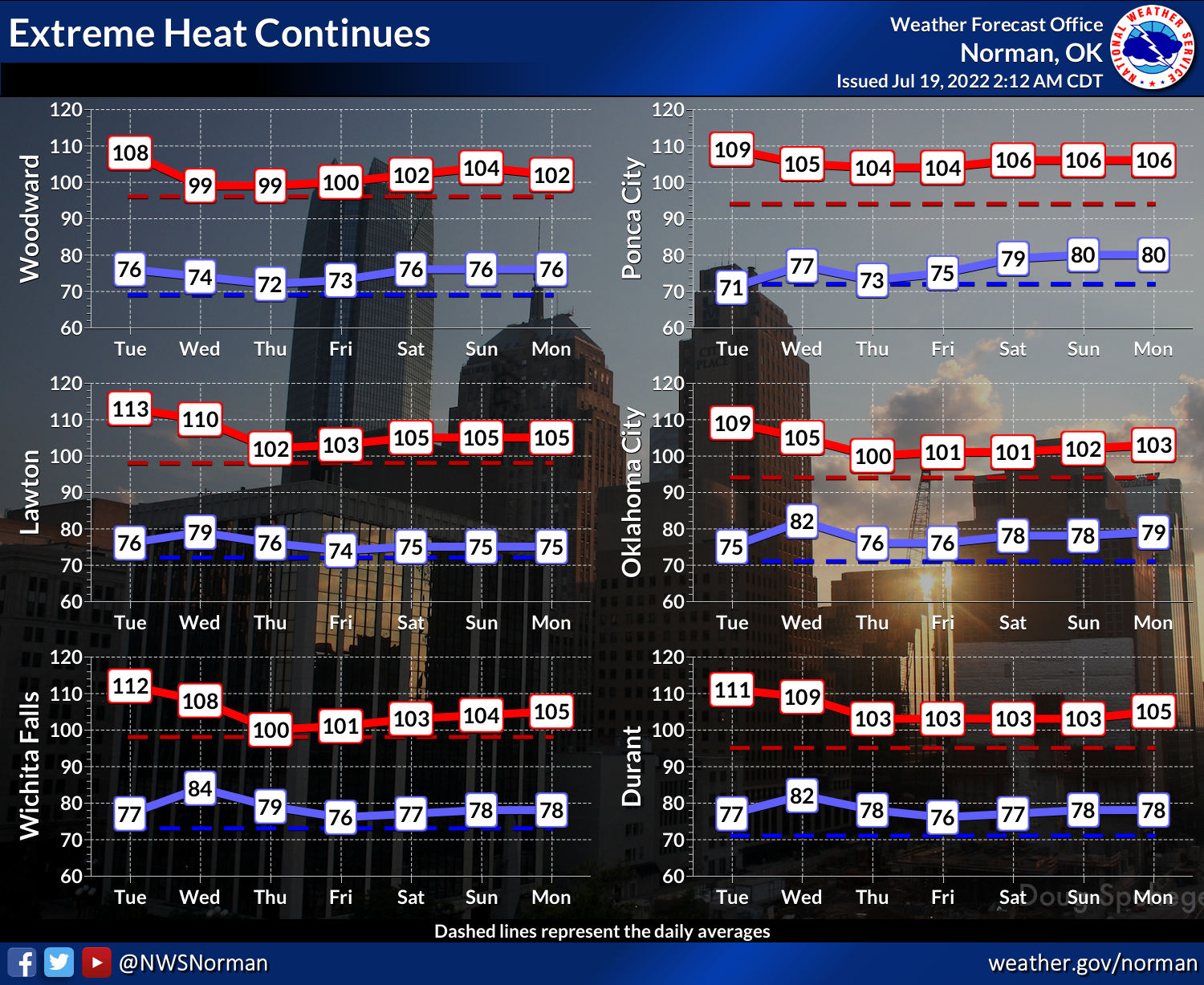
But at least we will see a big cooling trend after today. You know, from
decadal-scale heat to "wow, it's really hot out here."
https://ticker.mesonet.org/archive/20220719/nws-norman-7day-temps.png
We can make it. At least days like this are not quite here yet.
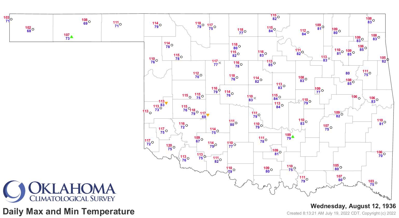
https://ticker.mesonet.org/archive/20220719/aug12-1936-120.altus.png
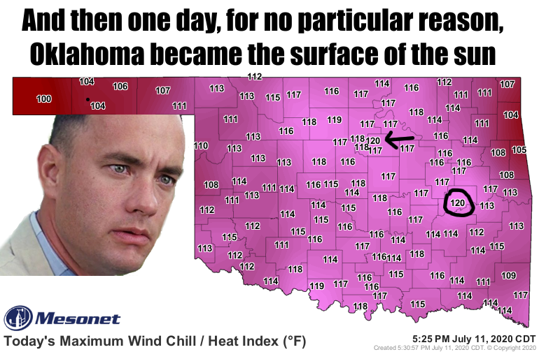
And sometimes we can forget just how hot it got recently, or at least just
how hot it felt with this heat index map from July 11, 2020. Hi Forrest!
https://ticker.mesonet.org/archive/20220719/remember-july11-2020.png
Some relief showing up on the long-range Fantasy-Casts around the first of
August. We promise nothing!
Gary McManus
State Climatologist
Oklahoma Mesonet
Oklahoma Climatological Survey
gmcmanus@mesonet.org
==================================================
The OCS/Mesonet Ticker
https://ticker.mesonet.org/
To subscribe or unsubscribe from the Ticker
or for questions about the Ticker or its content
Phone or Email the Ticker Manager at OCS
Phone: 405-325-2253 Email: ticker@mesonet.org
---------------------------------------------------
-C- Copyright 2024 Oklahoma Climatological Survey
===================================================
|


 Tweet
Tweet