Ticker for July 5, 2012
MESONET TICKER ... MESONET TICKER ... MESONET TICKER ... MESONET TICKER ...
July 5, 2012 July 5, 2012 July 5, 2012 July 5, 2012
Droughtious Interruptus
Yes, drought did continue to expand and intensify across the state as the heat
continues unabated for now. But the good news is there is possible relief in
store for us next week with the arrival of cooler air and even some rain.
For now, though, there continues to be an incredible amount of drought painted
onto the U.S. Drought Monitor map. The newest version, released this morning,
shows the damage. Over 51% of the lower 48 is now designated with drought to
some degree of intensity. That's up from 37% three months ago, a testament to
the heat wave over that span.
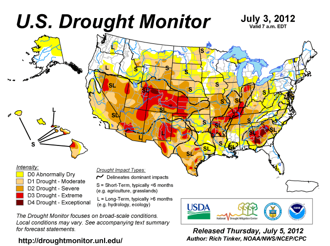
Closer to home, the state jumped from 48% drought coverage to 61%, although the
entire state is classified as being at least abnormally dry.
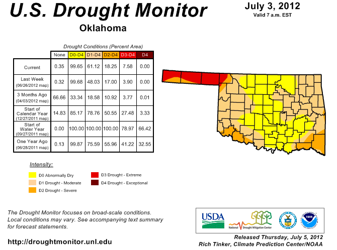
In particular, coverage increased across eastern and western Oklahoma while the
center corridor of the state managed to hold onto the D0 designation. The reasons
are obvious, of course, with the relentless heat, wind, sunshine and lack of
rainfall continuing to leech moisture from the soil and surface reservoirs. The
statewide average rainfall total over the last 30 days was 1.78", 2.26" below
normal (or about 44% of normal). That's the seventh driest such June 5-July 4
period since 1921.
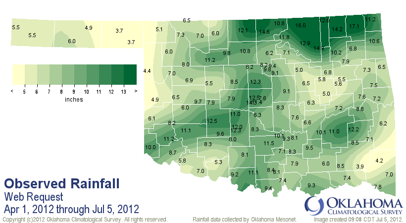
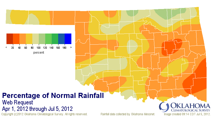
The deficits continue to mount from the beginning of our max rainy season. The
average since April 1 is 8.23", 4.9" below normal (or about 63% of normal). Now
that includes some big rains across the northern edge of the state and down
in south central Oklahoma. But the bigtime deficits remain in the southeastern
corner where departures are now up to a foot of rainfall in some places (or
20-60% of normal). Their average total is 8.77", 8.85" below normal. Our Mesonet
site at Cloudy has had 3.9 inches since April 1. That's less than most of our
Panhandle stations!
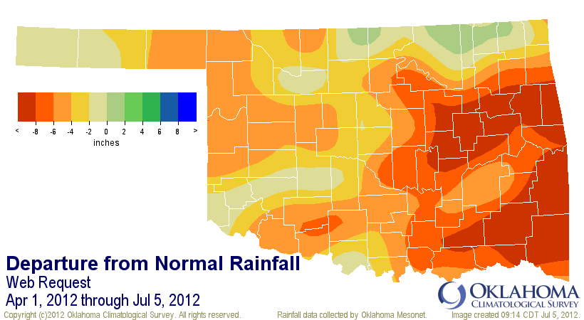
For southeastern Oklahoma, that's the driest such period dating back to 1921
when our best data begins. East central Oklahoma is not much better off at 7.4",
7.97" below normal and ranked as the third driest. Fire danger is on the rise,
and I saw quite a few fires undoubtedly started by fireworks yesterday on a trip
through western Oklahoma.
Now for the good news ... a frontal system should screech through the area
next Sunday, bringing much cooler weather (maybe even some below-normal readings)
and the possibility of rain. The rainfall is just now beginning to show up on
the HPC 5-day rainfall forecasts.
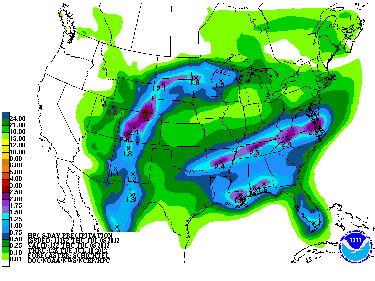
Expect highs in the mid-80s to lower 90s from Monday-Wednesday at least. That
will put a halt to the acceleration of the drought and any rain that falls will
add to the slowing. The NWS' Climate Prediction Center still feels that drought
will persist or intensify where it already exists in Oklahoma through the
"normally" dry summer months.
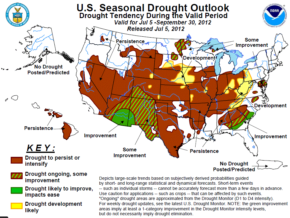
Broad relief is expected to our west associated with the summer monsoonal rains,
so maybe our Panhandle area can see some of that moisture.
I saw some really bad looking non-irrigated cotton yesterday, so I know the
heat and lack of rainfall are starting to take their toll. Reports of ponds drying
up and warm season grasses either not recovering from last year's heat/drought
or going dormant are also on the rise.
The best salve for our current summer woes will arrive in part next week. Let's
hope it sticks around for awhile. We didn't see that type of relief last summer
until a few days into September, so enjoy it while you can.
Gary McManus
Associate State Climatologist
Oklahoma Climatological Survey
(405) 325-2253
gmcmanus@mesonet.org
July 5 in Mesonet History
| Record | Value | Station | Year |
|---|---|---|---|
| Maximum Temperature | 107°F | WALT | 2011 |
| Minimum Temperature | 50°F | KENT | 2004 |
| Maximum Rainfall | 6.39″ | HOBA | 2010 |
Mesonet records begin in 1994.
Search by Date
If you're a bit off, don't worry, because just like horseshoes, “almost” counts on the Ticker website!