Ticker for July 6, 2012
MESONET TICKER ... MESONET TICKER ... MESONET TICKER ... MESONET TICKER ...
July 6, 2012 July 6, 2012 July 6, 2012 July 6, 2012
Burn bans on the rise, lakes on the decline
The building drought and its associated impacts will continue for a couple more
days until we get some relief ... in temperature for certain if not in moisture.
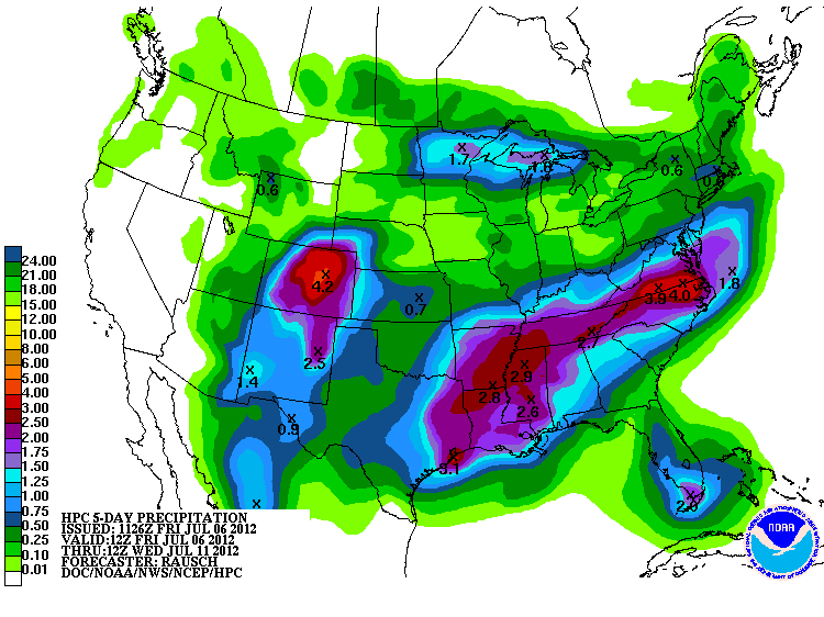
The forecasts are starting to paint more and more rainfall with the coming
front. Looks a little like fantasy-land (yeah, I need to get out more), but it
is certainly a good picture for July.
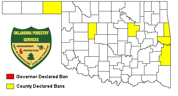
Until then, back to reality. Several counties in the hardest hit areas have added
burn bans recently. We might expect a bit of a slowdown of the progression for
additional bans across the state next week, but here is the burn ban map as of
now.
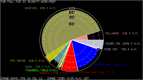
Lake levels are still showing stress in some areas, and continue to head in that
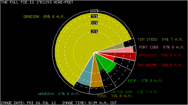
direction in others. Here are the pie charts of the conservation pools for
reservoirs in the various basins across the state. The size of the pie slice is
proportionate to the lake's share of the total conservation storage in the basin.
The radius of the pie slice indicates the percent of the lake's conservation
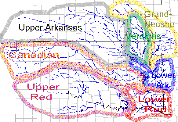
storage that is filled at the time indicated. Here is a map of the storage
basins, for reference.
Upper Red River Basin
A lot of these reservoirs have shown in this basin have been low and stayed low.
Of particular interest is the important irrigation water of Lake Altus, down to
22%. Very little water is available to irrigate the cotton crop in that area.
Canadian River Basin
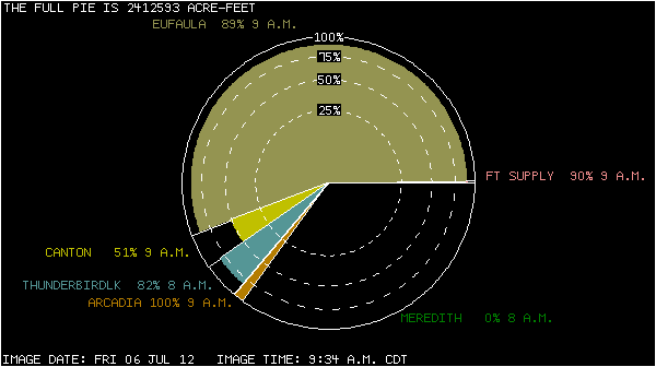
Lake Meredith is an Amarillo problem, but an Oklahoma lake of interest is Canton
Lake. Not only is it an important recreational lake in the Canton area, it is
also one of Oklahoma City's backup water supplies. At 51%, it has not recovered
much at all since last year's drought. It stood at 56% in early June. Lake
Eufaula has been declining steadily for a few months, a natural result of lack
of rainfall and evaporation due to the heat.
Eufaula: 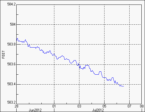
Upper Arkansas River Basin
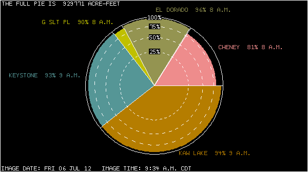
Nothing really alarming here. This is the area that had a bunch of rainfall
during the spring, at least in some areas.
Verdigris River Basin
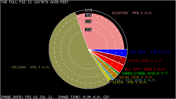
Skiatook is the problem child here. It went as low as 66 percent last fall
but rebounded with the rains of March and April. It's starting to head south
again though. It was at 86% in early June, now at 84%. Nothing a good storm won't
cure.
Skiatook: 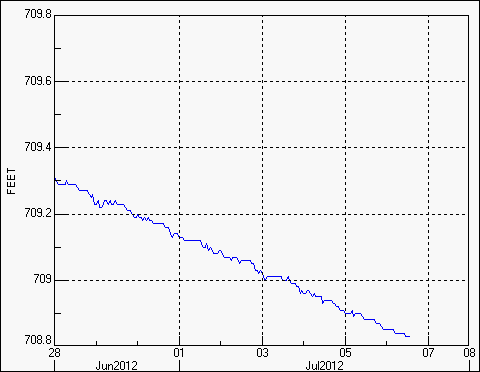
Grand-Neosho River Basin
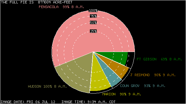
Ft. Gibson is down to 69%. That's in that intensifying drought area in east
central Oklahoma and will continue to decline without additional rainfall.
Ft. Gibson: 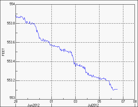
Lower Arkansas River Basin
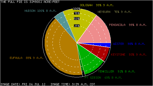
This area is in good shape, relatively, but slow/steady declines continue.
Lower Red River Basin
Again, a lot of areas of concern with one of the worst drought areas in the
state. Lots of shrinking reservoirs. Broken Bow was 99% full back in early May,
now down to 82% after a couple of dry and hot months. Hugo was at 93% in early
May, now down to 70%.
Some of this is something to be expected during summer, at least for those
lakes showing steady declines while still in "okay" territory. However, it's
more of a look suited later for August. So the declines have had a month or two
of a head start. For those reservoirs that have yet to show any sort of
substantial improvement since the height of last year's drought, there is a bit
more alarm centered on those with two full months of summer left. And this
should be an indication of what is happening with stock ponds in the different
areas of the state.
Gary McManus
Associate State Climatologist
Oklahoma Climatological Survey
(405) 325-2253
gmcmanus@mesonet.org
July 6 in Mesonet History
| Record | Value | Station | Year |
|---|---|---|---|
| Maximum Temperature | 108°F | GRA2 | 2011 |
| Minimum Temperature | 53°F | GOOD | 1997 |
| Maximum Rainfall | 3.57″ | WATO | 2015 |
Mesonet records begin in 1994.
Search by Date
If you're a bit off, don't worry, because just like horseshoes, “almost” counts on the Ticker website!