Ticker for July 2, 2012
MESONET TICKER ... MESONET TICKER ... MESONET TICKER ... MESONET TICKER ...
July 2, 2012 July 2, 2012 July 2, 2012 July 2, 2012
June is in the books, but first...a nice correlation
I have certainly blathered on and on about the relationship between drought and
extreme heat, so I thought it was a good time to see how it works out in the
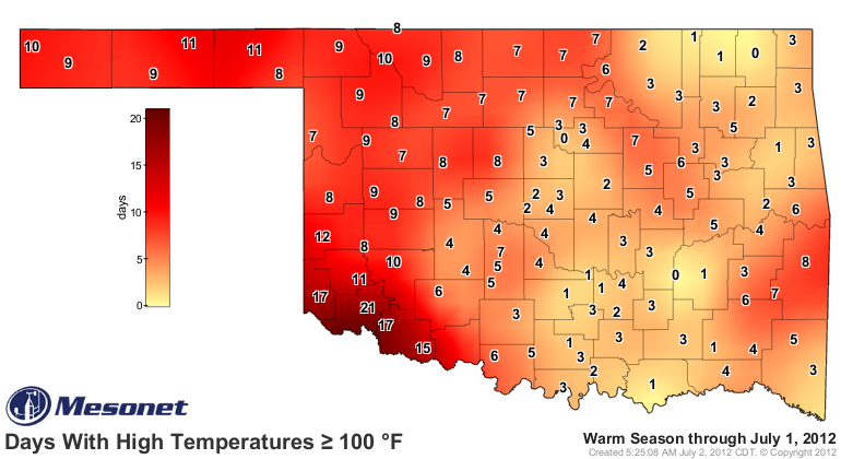
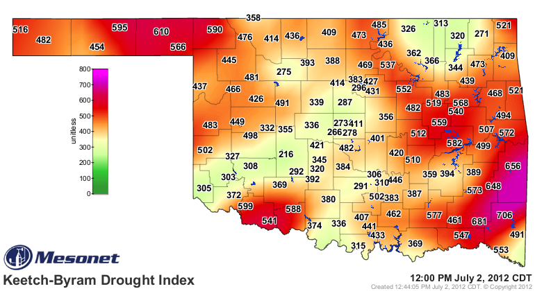
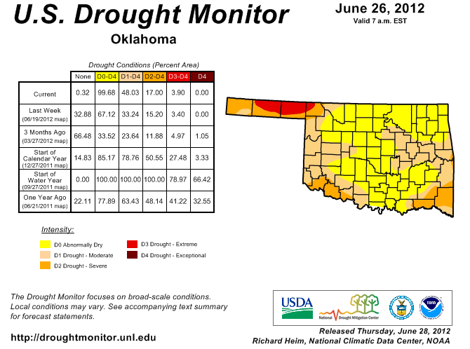
Mesonet data. Check out how the map of 100-degree days thus far in 2012 match
up to our drought monitoring maps, especially the KBDI (Keetch-Byram Drought
Index) map powered by data from the Oklahoma Mesonet.
Days Above 100 degrees
U.S. Drought Monitor and KBDI maps
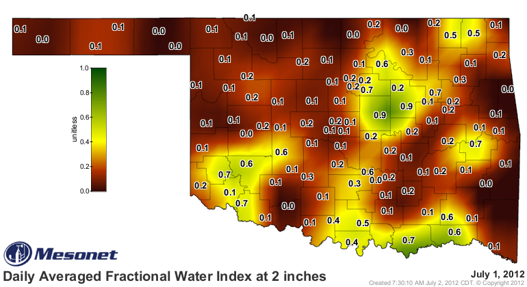
Explanation...quick version: less soil moisture and more dormant and/or dead
vegetation leads to more heating thanks to less of the sun's radiation being
used for photosynthesis or evaporating soil moisture, both of which are
cooling processes. Verrrrry interesting. The drying of Oklahoma continues
before our very eyes.
Or Mesonet maps.
--------------------------------------------------------------------------------
June Ends On A Scorching Note
A blistering final week and a return to drought transformed June from a mildly
hot month into a scorcher, rekindling memories of the brutal 2011 summer.
Temperatures routinely reached triple-digits across Oklahoma during the month?s
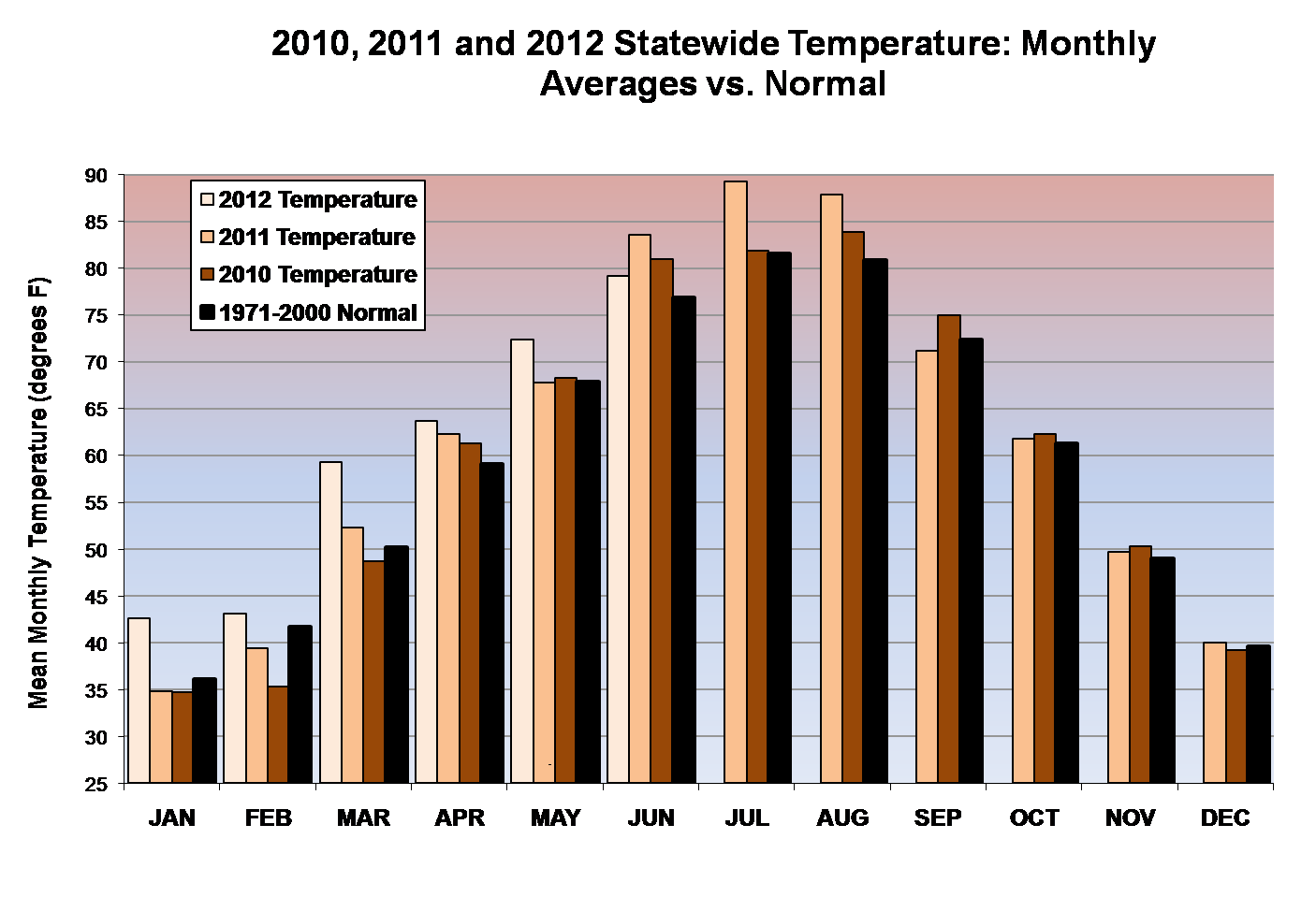
final week. According to data from the Oklahoma Mesonet, the statewide average
temperature finished at 79.2 degrees to rank as the 19th warmest June on record,
2.7 degrees above normal. Statewide average records date back to 1895. June?s
warmth follows a pattern that began over two years ago with 22 out of the last
27 months being warmer than normal. The January-June statewide average entered
the record books at 60.1 degrees, 4.9 degrees above normal. That obliterates the
previous record mark of 58.9 degrees from the same period in 2006 as the state
continues on a possible path towards its warmest year on record. Oklahoma?s
warmest year on record came in 1954 with a statewide average of 62.8 degrees.
The January-June statewide average that year was 57.4 degrees.
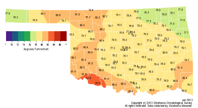
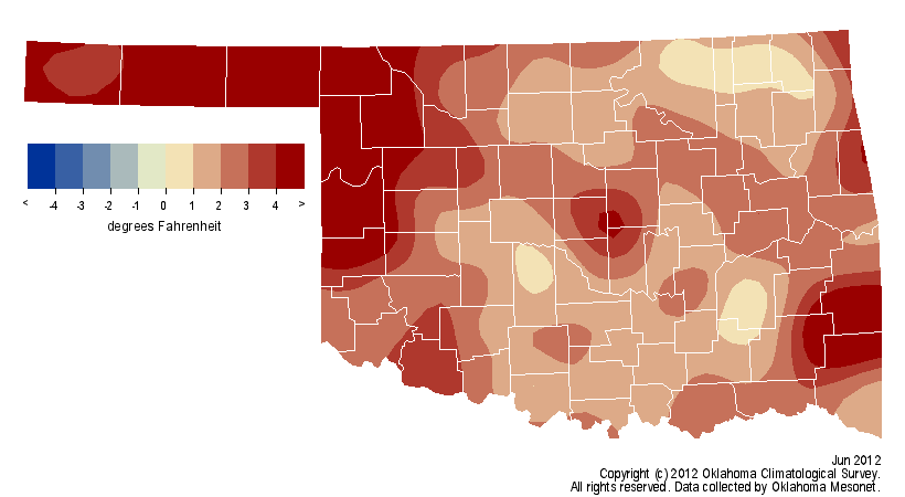
The highest temperature recorded during the month was 112 degrees at Buffalo
and Freedom on the 26th and again at Buffalo on the 27th. High temperatures
across parts of the state were in the 70s as late as June 21. The lowest
temperature recorded during the month was 44 degrees at Oilton and Cookson on
the first.
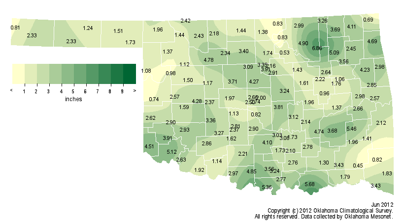
The month was also the 29th driest June on record with a statewide average
precipitation total of 2.54 inches, nearly 2 inches below normal. A few
localized areas received significant moisture during the first two weeks of the
month before the state adopted the much more summer-like pattern. The Mesonet
site at Skiatook led June?s rain totals with 6.86 inches while the small town
of Cloudy brought up the rear with 0.45 inches. The state saw significant
drought relief from October 2011 through March of this year, but the rains
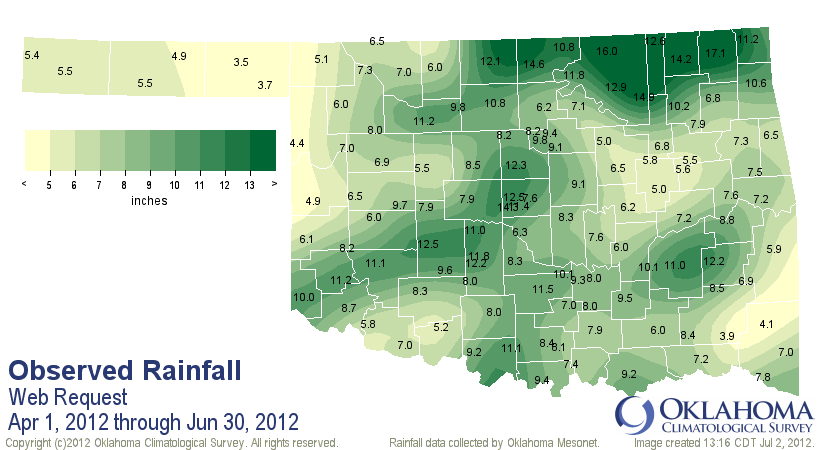
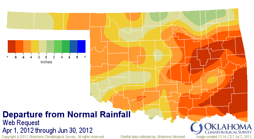
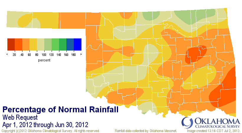
have since dwindled. The southeast and east central sections of the state were
below 50 percent of normal since April 1, a slowdown that encompassed the
entirety of Oklahoma's primary rainy season. Statewide, the average total of
8.2 inches is 4.5 inches below normal, the 14th driest such period on record.
June 2012
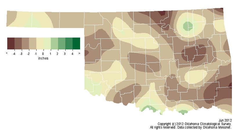
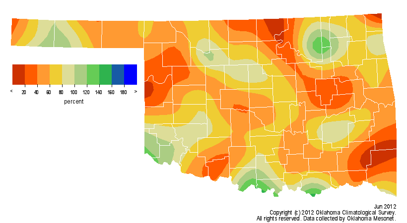
April-June 2012
Fueled by oppressive heat, intense sunshine, dwindling soil moisture and the
recent lack of rainfall, drought continued to develop rapidly across the state.
Over 48 percent of the state is now considered to be in drought according to
the latest U.S. Drought Monitor report. For the first time since November 15,
2011, the entire state is now considered at least "abnormally dry.? That
designation is a drought pre-cursor that identifies an area that is dry, but
not yet in drought. The dryness that has continued to intensify across Oklahoma
is hardly confined to our state, with 72 percent of the country now labeled in
the abnormally dry category or worse. That is the largest such extent covering
the United States since the Drought Monitor effort began in 1999. More than 51
percent of the country is considered to be in drought, the largest such extent
since September 2003.
Summer is normally a time of moisture depletion with losses from evaporation,
plants and human consumption far outpacing rainfall. By late July and early
August, the state?s vegetation often develops a distinct yellow hue as it
begins to wither and go dormant, the perfect fuel for wildfires. With the two
warmest and driest months of the summer still to come, the intensifying drought
is a reason for concern. Odds favor more drought development as summer trudges
ahead and a dry Oklahoma looks with anticipation towards the fall rainy season.
Gary McManus
Associate State Climatologist
Oklahoma Climatological Survey
(405) 325-2253
gmcmanus@mesonet.org
July 2 in Mesonet History
| Record | Value | Station | Year |
|---|---|---|---|
| Maximum Temperature | 107°F | KIN2 | 2024 |
| Minimum Temperature | 49°F | SEIL | 2013 |
| Maximum Rainfall | 6.98″ | FITT | 2017 |
Mesonet records begin in 1994.
Search by Date
If you're a bit off, don't worry, because just like horseshoes, “almost” counts on the Ticker website!