MESONET TICKER ... MESONET TICKER ... MESONET TICKER ... MESONET TICKER ...
June 1, 2023 June 1, 2023 June 1, 2023 June 1, 2023
Rain Alone
https://ticker.mesonet.org/archive/20230601/48hour-forecast.png
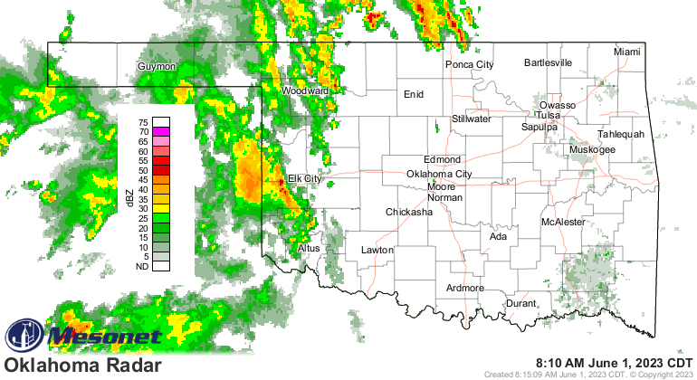
Holy tropical western Oklahoma, Batman! I'll be darned if the western third of
the state hasn't done transformed itself into a national envy over its rainfall
forecasts and totals. AND HECK, IT'S RAINING RIGHT NOW FOR CRYING OUT LOUD!
https://ticker.mesonet.org/archive/20230601/current-radar.png
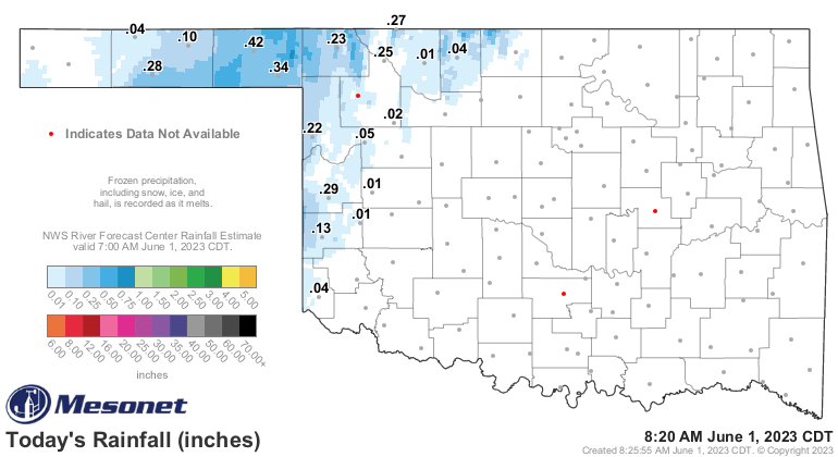
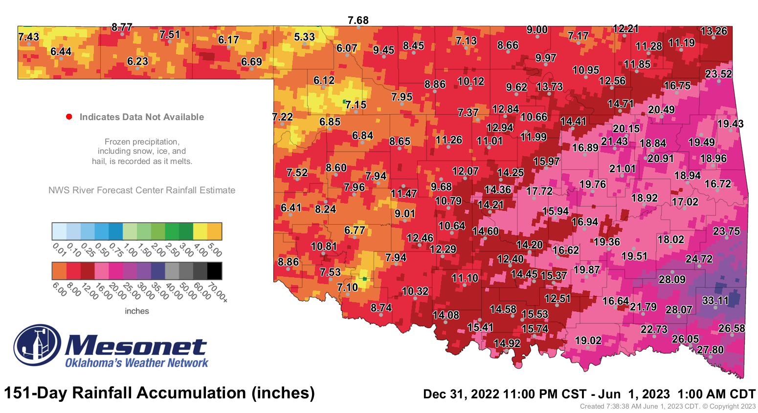
And totals continued to rise overnight into this morning.
https://ticker.mesonet.org/archive/20230601/today.rainrfc.png
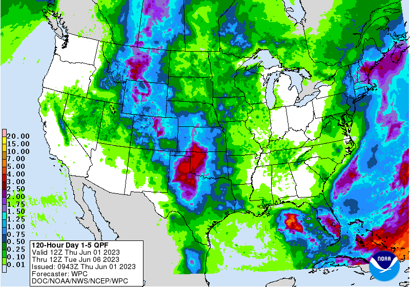
And a lot more is expected through the weekend in addition to what could fall
over the next couple of days.
https://ticker.mesonet.org/archive/20230601/5day-rain-forecast.gif
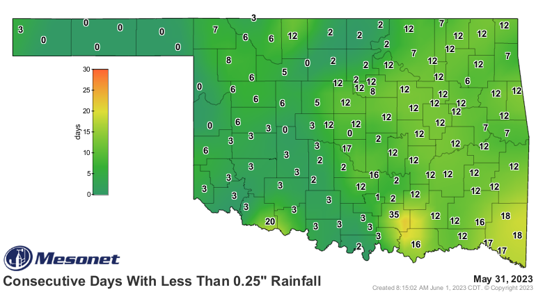
But even as we celebrate western Oklahoma's bounty, we cast our drought-eyes
over to eastern Oklahoma, where D0-Abnormally Dry conditions are starting
to spread on the U.S. Drought Monitor (see May summary below) and the days
without significant rainfall mount.
https://ticker.mesonet.org/archive/20230601/mesonet.rainfall.quarterinch.png
Now May was momentous for it's central Oklahoma tornado records (see below...no,
not that below...farther), but heck, it was Eva's rainfall total that was the
big story, for crying out loud!
Yes, so big that I doubled down on my "for crying out loud"s.
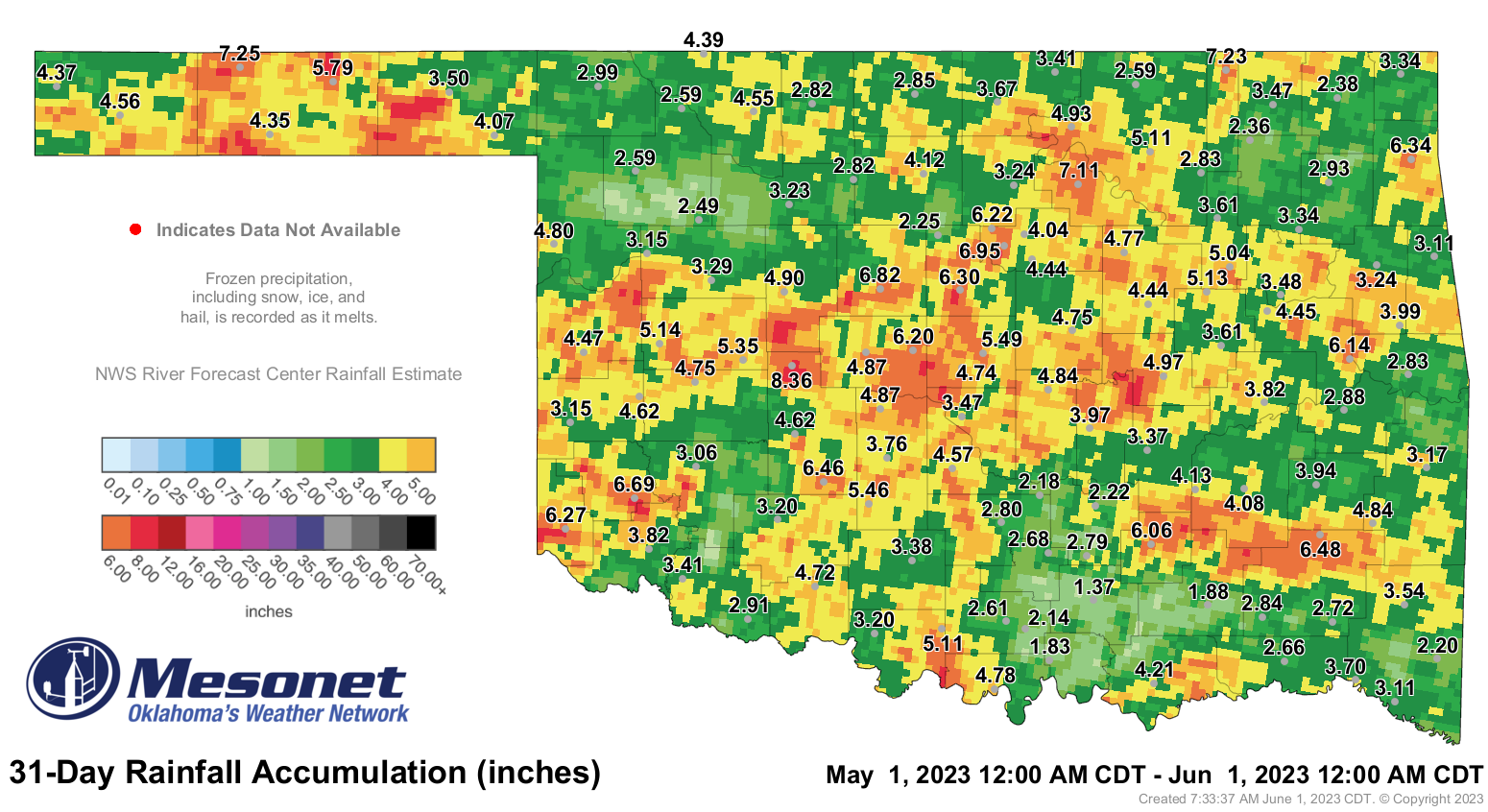
https://ticker.mesonet.org/archive/20230601/May2023.png
7.25 inches of rain at Eva? EVA?? That's not the Eva I know. That's like a
half-year's worth of rainfall for that area, and their rainy season doesn't
start until later into the summer. That's like nearly 6 inches above normal and
over 300% above normal (see below!! Are you not paying attention??)!
Well I'm not going to yell too much because parts of Oklahoma still need
the rainfall pretty desperately. There's a good chance we could fill those
holes in the next 5 days, however. Now stick around and read the May summary
below.
For crying out loud.
----------------------------------------------------------------------------------
Tornado Records Fall During May
June 1, 2023
Central Oklahoma has often been characterized as a haven for tornadoes, with some
of that perception based in reality—and myth. There has been nothing mythical
about that reputation in 2023, however. At least 11 tornadoes touched down in
central Oklahoma on May 11, adding to persistent tornadic activity in that
region during the previous 4 months of the year. Through just 5 months, the
central Oklahoma counties of Cleveland and McClain broke their records for
number of tornadoes in a calendar year with preliminary totals of 13 and 11,
respectively. The previous record for Cleveland County was 7 in 2010, as well
as for McClain County in 2011. The record calendar year total for any county
remains 16 for Kingfisher County back in 1999, which all occurred during the
infamous May 3 tornado outbreak. Additionally, the 28 tornadoes combined
through May in Cleveland, McClain, and Pottawatomie counties smashed their
previous record of 11, set in 2010 and 2015. Eight of those tornadoes were
rated EF2 or higher. Another twister touched down in Kay County on May 12 for a
preliminary total of 12 for the month, bringing the 2023 total up to 50 through
May. Oklahoma averages 57.3 tornadoes in a calendar year, based off of data
from 1950 through 2022.
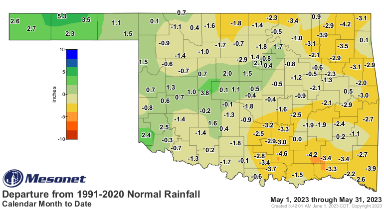
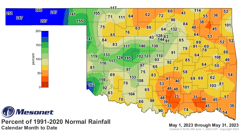
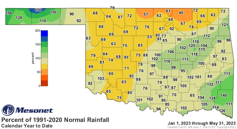
The statewide average rainfall total finished the month at 4.09 inches, 0.84
inches below normal and ranked as the 53rd driest May since records began in
1895. Surpluses reigned across far western into central Oklahoma, but deficits
of 2-4 inches were still widespread across the rest of the state. The Oklahoma
Mesonet site at Hinton recorded the highest total of 8.36 inches, with the
Panhandle site at Eva garnering an incredible 7.25 inches in second place, 5.3
inches above normal for that arid region. Tishomingo had the lowest total at
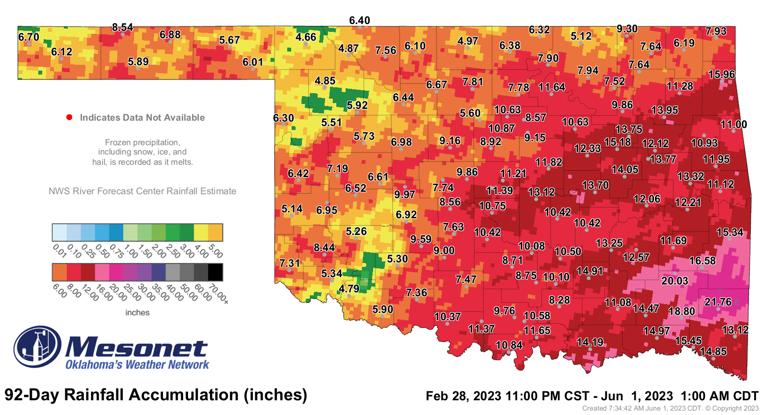
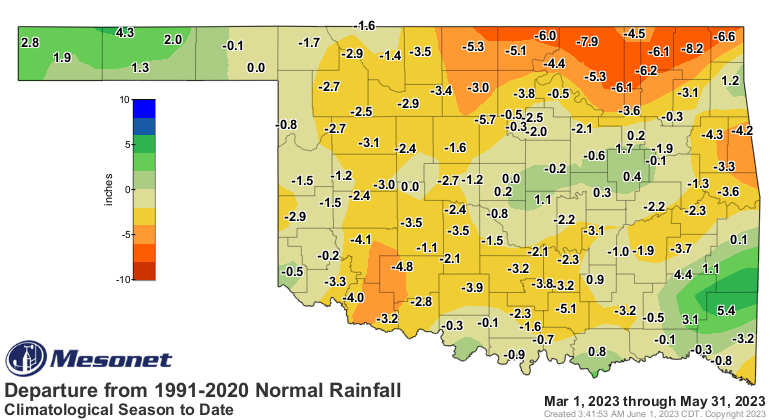
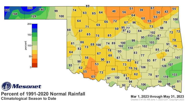
1.37 inches, 4.6 inches below normal for the month. Climatological spring—March
1 through May 31—finished with a statewide average of 9.45 inches, 1.85 inches
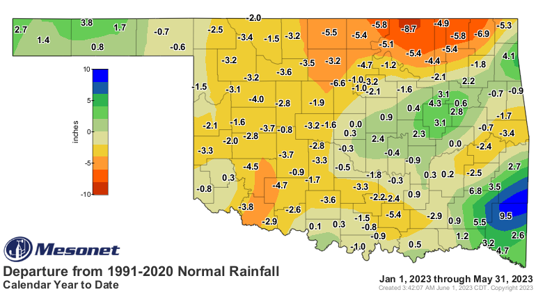
below normal and ranked as the 42nd driest March-May on record. The statewide
average for the first five months of the year was 13.21 inches, 1.35 inches
below normal and ranked as the 65th driest January-May on record.
https://ticker.mesonet.org/archive/20230601/May2023.png
https://ticker.mesonet.org/archive/20230601/delmonth_rain.current.png
https://ticker.mesonet.org/archive/20230601/pctmonth_rain.current.png
https://ticker.mesonet.org/archive/20230601/spring2023.png
https://ticker.mesonet.org/archive/20230601/delseason_rain.current.png
https://ticker.mesonet.org/archive/20230601/pctseason_rain.current.png
https://ticker.mesonet.org/archive/20230601/Jan-May2023.png
https://ticker.mesonet.org/archive/20230601/delcalendaryear_rain.current.png
https://ticker.mesonet.org/archive/20230601/pctcalendaryear_rain.current.png
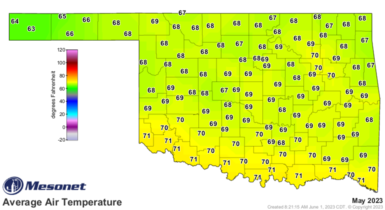
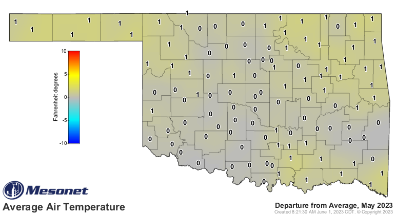
The statewide average temperature was 68.8 degrees for the month, 0.4 degrees
above normal and ranked as the 46th warmest May since records began in 1895. A
warm first half of the month buoyed that ranking despite milder conditions
during May’s last half. The state’s highest temperature was 99 degrees at Altus
on May 5 and 6, and again at Buffalo on May 7. There were no 90s recorded in
the state between May 12-30, and 43 of the Mesonet’s 120 sites still had not
reached 90 degrees by the end of the month. The lowest recorded temperature was
32 degrees at Lake Carl Blackwell on May 1 and again at Nowata on May 3, the
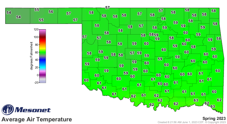
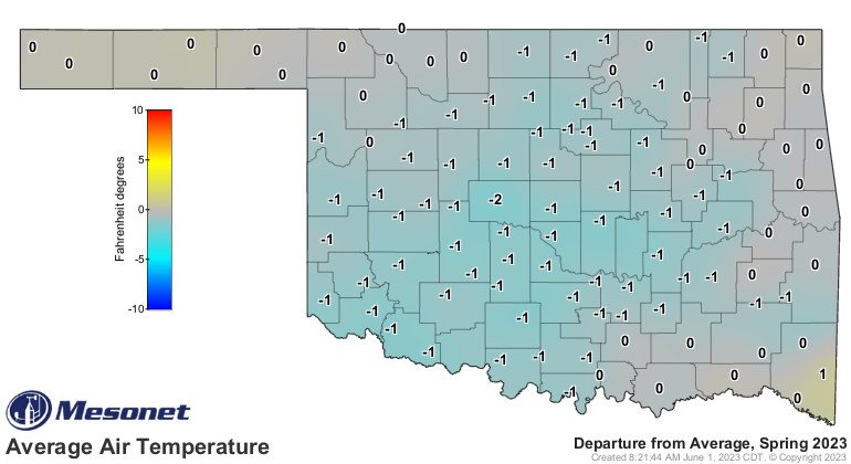
latter being the last spring freeze for the state. Climatological spring ended
as the 59th warmest on record and 0.4 degrees below normal at 59.3 degrees. The
first five months of the year remained quite warm at 52.9 degrees, 0.8 degrees
above normal and the 23rd warmest January-May on record.
https://ticker.mesonet.org/archive/20230601/may-avg-temps.png
https://ticker.mesonet.org/archive/20230601/may-avg-temps-depart.png
https://ticker.mesonet.org/archive/20230601/spring-avg-temps.png
https://ticker.mesonet.org/archive/20230601/spring-avg-temps-depart.png
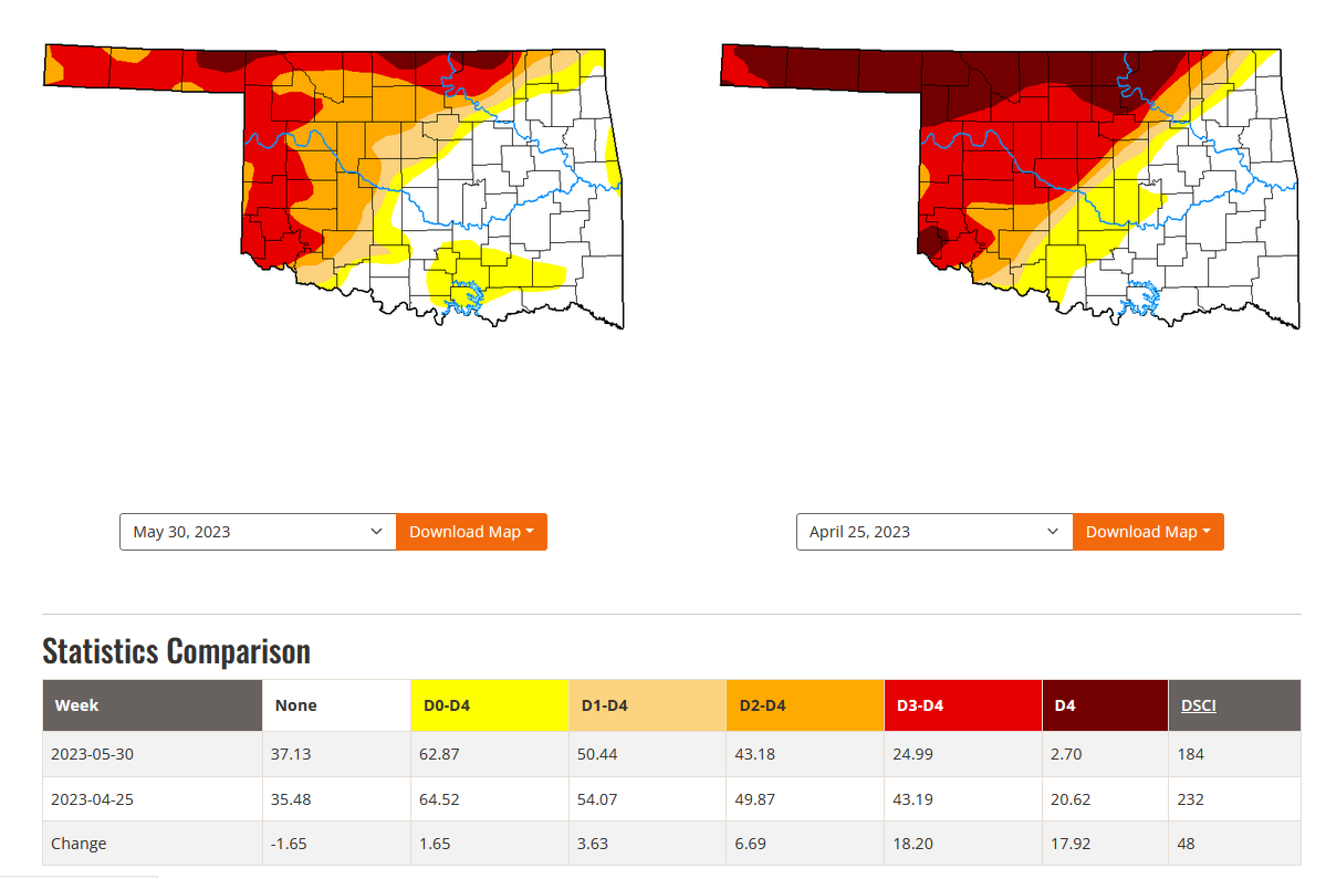
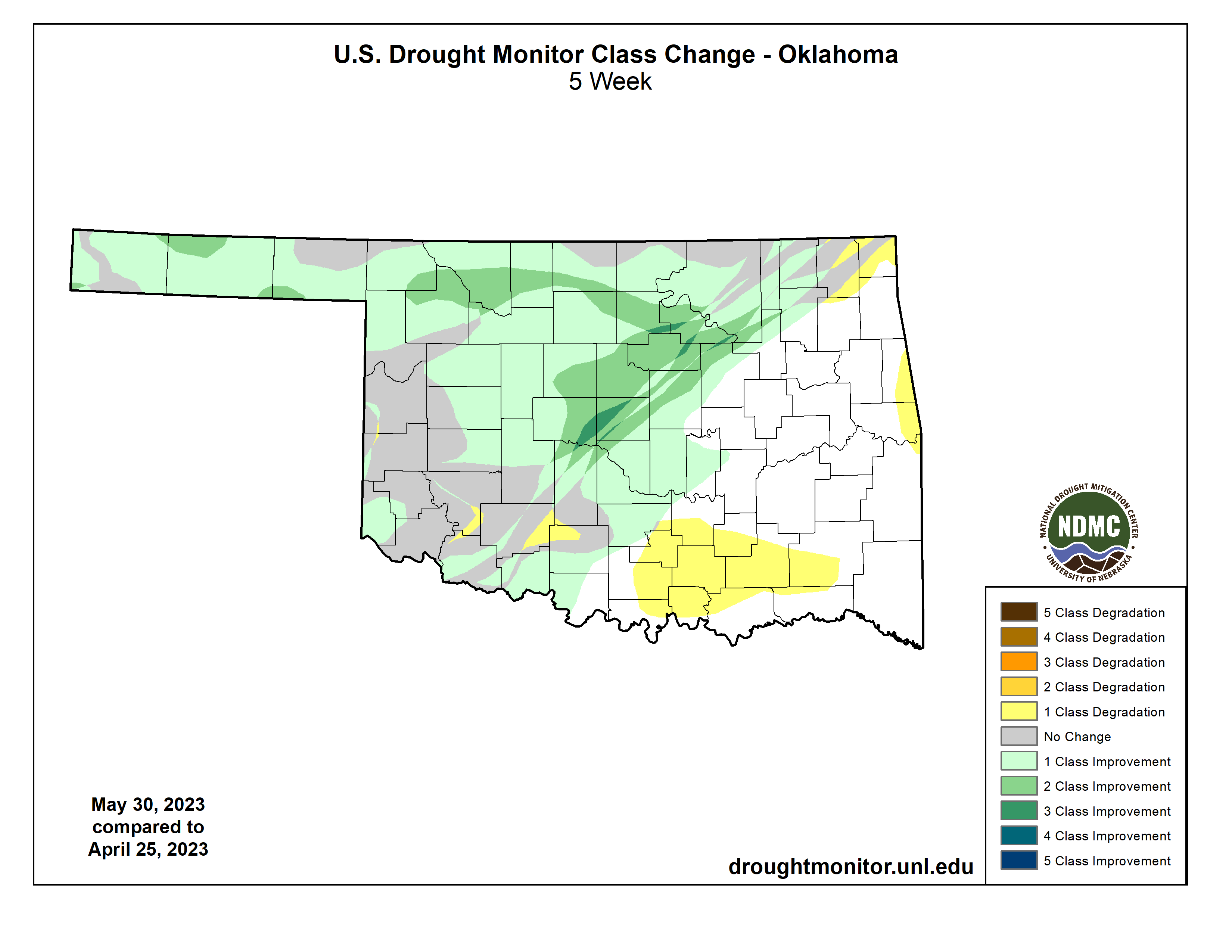
Drought severity lessened significantly through the month, with the amount of
extreme-to-exceptional drought dropping from 43% at the end of April to 25% at
the end of May according to the U.S. Drought Monitor. However, at least 50% of
the state was still in at least moderate drought at the end of May. The Drought
Monitor’s intensity scale slides from moderate-severe-extreme-exceptional, with
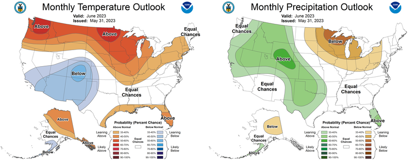
exceptional being the worst category. The June outlooks from the Climate
Prediction Center call for increased odds of below normal temperatures across
far western Oklahoma and the Panhandle, and above normal rainfall across the
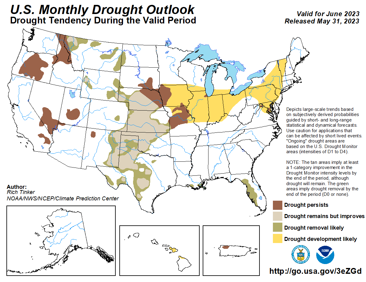
entire state, but especially across the western half. CPC’s June drought outlook
indicates drought improvement across the entire Southern Plains—including
Oklahoma—where it currently exists.
https://ticker.mesonet.org/archive/20230601/Apr25-to-May30-DM.png
https://ticker.mesonet.org/archive/20230601/DM-change-apr25-may30.png
https://ticker.mesonet.org/archive/20230601/june-outlooks.png
https://ticker.mesonet.org/archive/20230601/june-drought-outlook.png
###
Gary McManus
State Climatologist
Oklahoma Mesonet
Oklahoma Climatological Survey
gmcmanus@mesonet.org
==================================================
The OCS/Mesonet Ticker
https://ticker.mesonet.org/
To subscribe or unsubscribe from the Ticker
or for questions about the Ticker or its content
Phone or Email the Ticker Manager at OCS
Phone: 405-325-2253 Email: ticker@mesonet.org
---------------------------------------------------
-C- Copyright 2024 Oklahoma Climatological Survey
===================================================
|


 Tweet
Tweet