MESONET TICKER ... MESONET TICKER ... MESONET TICKER ... MESONET TICKER ...
May 19, 2011 May 19, 2011 May 19, 2011 May 19, 2011
Same as it ever was, and a look ahead
The new U.S. Drought Monitor came out this morning with very few surprises.
http://ticker.mesonet.org/archive/20110519/ok_dm.png
We went from D2 to D1 along the eastern edge of the I35 corridor and also have
a notch of D2 extending down into the southwest, all courtesy of last week's
weird rainfall patterns. Unfortunately, extreme (D3) drought has expanded in
western Oklahoma up through the Kansas state line. We have the pictures I
showed earlier this week of my dessicated fishing hole and reports of
widespread cattle herds being liquidated to thank for that expansion. Oh yeah,
and the prolonged lack of rainfall.
*You may ask yourself* why your area is still in drought even though you
have received rainfall. Chances are you've been lulled into a false sense of
moisture-security. It's like when you went to the cafeteria in high school and
asked for a second helping of pizza pockets but the lunch lady gave you extra
corn instead. You THOUGHT you came out ahead on the deal, but only later did
you realize a fast one was pulled.
Counting to 10 ... I thought I was over that!!
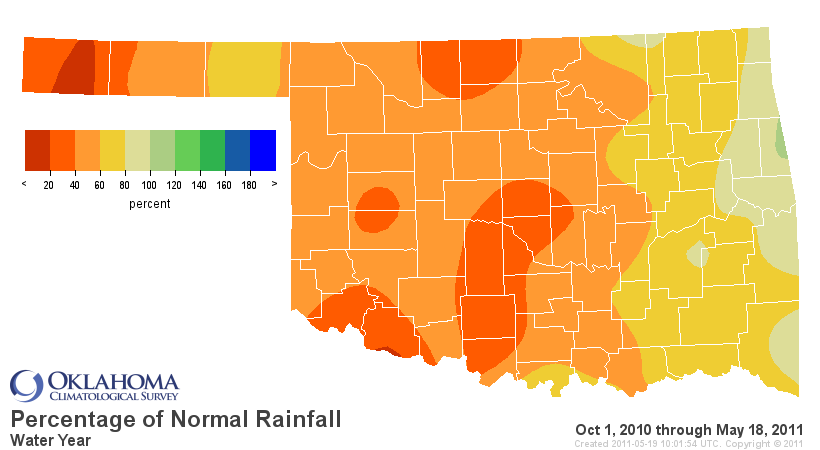
Case in point, you THINK you have had decent rainfall, but the statistics may
say otherwise. Take any period you want, most of you are still well below
normal. In precipitation too (you'll get that one later).
http://ticker.mesonet.org/archive/20110519/last90dayspct.png
http://ticker.mesonet.org/archive/20110519/last180dayspct.png
http://ticker.mesonet.org/archive/20110519/wtrpct.png
*******************************************************
Looking ahead
How about prospects for the future? The Hydrometeorological Prediction Center
5-day precipitation forecast for today through next Tuesday morning shows a
familiar sight ... wet in the east and dryline-dependent (and lesser) totals in
western Oklahoma.
http://ticker.mesonet.org/archive/20110519/May19-24_totals.gif
So this is once again our big chance for relief. I'm optimistic that the
dryline will retreat tonight and most of western Oklahoma will get a
dust-settling dose of rain.
How about farther out? The Climate Prediction Center's outlook for June shows
an increased (but not significant) chance of below normal precipitation for
the western half of the state and an increased chance of above normal
temperatures for the southwestern half up through the Panhandle.
http://ticker.mesonet.org/archive/20110519/off14_prcp.gif
http://ticker.mesonet.org/archive/20110519/off14_temp.gif
With La Nina slowly fading away like my hairline, the driver of these
depictions is the lack of soil moisture over those areas. Less soil moisture
means more of the sun's energy goes to heating the lower atmosphere instead of
evaporation. And the lack of soil moisture decreases local moisture sources for
precipitation.
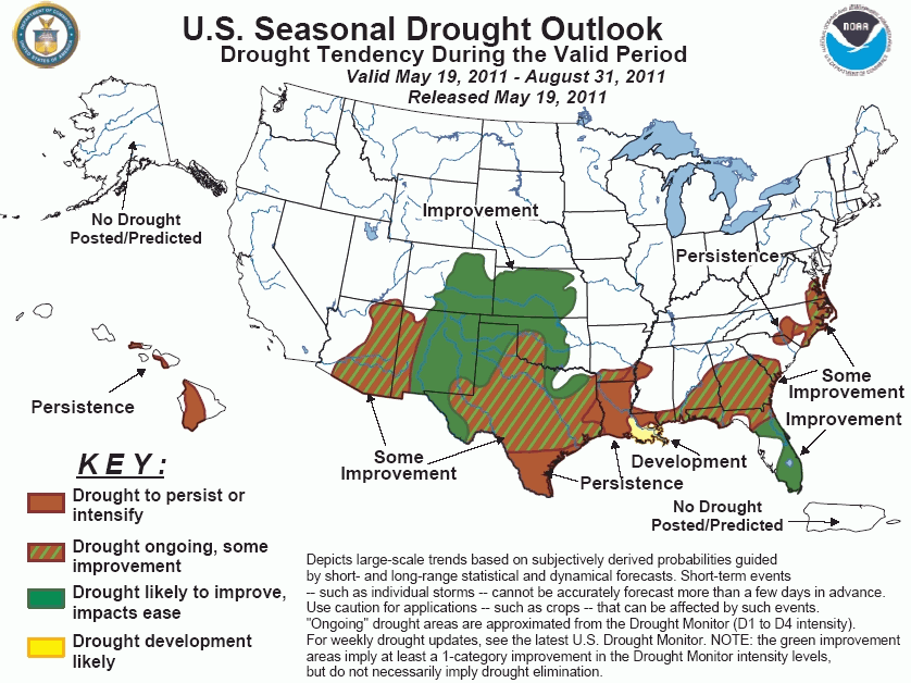
Finally, the latest U.S. Drought Outlook looks promising, sort of.
http://ticker.mesonet.org/archive/20110519/season_drought.gif
We see a chance of improvement through most of western Oklahoma, with "some
improvement" indicated in the southwest. As noted in the text, "green
improvement areas imply at least a 1-category improvement ... but do not
necessarily imply drought elimination." The forecaster for this map spelled it
out pretty plainly though:
"The forecasts of 'some improvement' and 'improvement' for the
parched areas of Texas and the southern High Plains were driven
by the approach of a neutral to climatologically wet season (summer)
which should provide at least some surface moistening, even if amounts
aren't unusually heavy. There is nothing to indicate that widespread,
significant drought relief should be expected during the forecast
period, though that of course is a possibility."
Translation? La Nina is going away, it's summer ... we should get at least
SOME rain, right? When it comes to predicting Southern Plains summers, that's
about as good of a prediction as you'll get.
As for myself, I'll be letting the days go by, water flowing underground.
Same as it ever was.
Gary McManus
Associate State Climatologist
Oklahoma Climatological Survey
(405) 325-2253
gmcmanus@mesonet.org
==================================================
The OCS/Mesonet Ticker
https://ticker.mesonet.org/
To subscribe or unsubscribe from the Ticker
or for questions about the Ticker or its content
Phone or Email the Ticker Manager at OCS
Phone: 405-325-2253 Email: ticker@mesonet.org
---------------------------------------------------
-C- Copyright 2024 Oklahoma Climatological Survey
===================================================
|


 Tweet
Tweet