MESONET TICKER ... MESONET TICKER ... MESONET TICKER ... MESONET TICKER ...
May 12, 2015 May 12, 2015 May 12, 2015 May 12, 2015
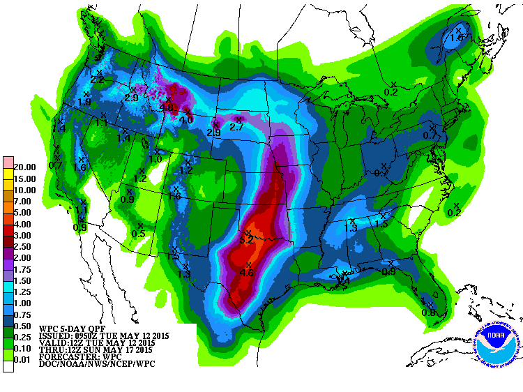
Are you ready for this?
At press time (i.e., whenever I send the Ticker), this reporter (I'm not really
a reporter, I have just always wanted to say that) notices that the rainfall
totals for tomorrow through the weekend appear to be somewhat excessive for
Oklahoma.
http://ticker.mesonet.org/archive/20150512/5day-rain-forecast.gif
Another 3-5+ inches over the next five days? Sounds good. We need the rain, right?
Oh yeah, well same to you!
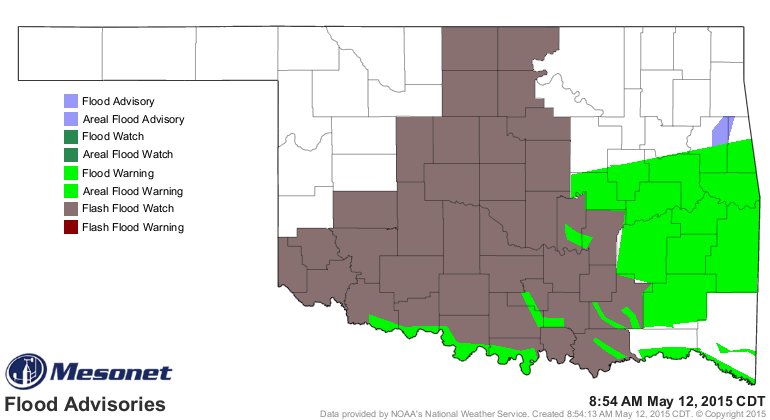
You can tell you don't really need topped off at the moment when you see flash
flood watches a couple of days prior to another rainfall event, along with a
bunch of flood warnings already in place.
http://ticker.mesonet.org/archive/20150512/latest.oklahoma.flood.gif
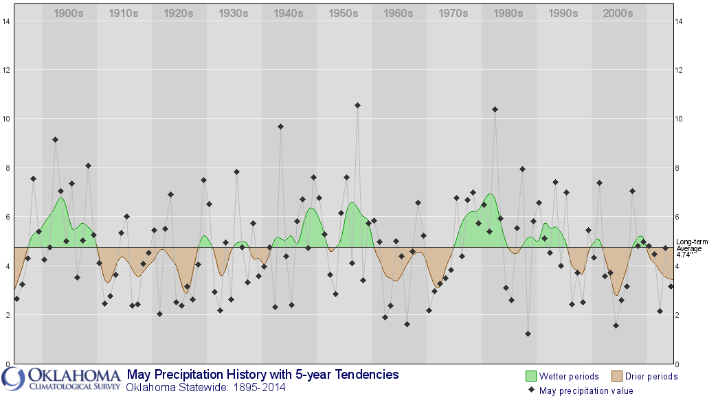
The statewide average rainfall total for May thus far is 5.14 inches, 3.36 inches
above normal for the 3rd wettest May 1-12 dating back to at least 1921. Now
here's the deal...in ranking May rainfalls (that's May 1-31) over the last few
years, the first 12 days of this May already ranks the entire month (with lots
more rain and lots more days to go) as the wettest since 2007's monthly total
of 7.05 inches. Here are the May total rainfalls since 2000, for emphasis.
2000: 4.34"
2001: 7.38"
2002: 3.56"
2003: 3.71"
2004: 1.56"
2005: 2.60"
2006: 3.16"
2007: 7.05"
2008: 4.80"
2009: 4.98"
2010: 4.80"
2011: 2.15"
2012: 2.15"
2013: 4.73"
2014: 3.14"
2015: 5.14" (through the morning of May 12)
The wettest May was 1957's 10.54 inches, a total that knocked the 1950s drought
right out of existence, at least for the most part. Here are the top-10 wettest
Mays on record.
1957: 10.54"
1982: 10.38"
1943: 9.66"
1902: 9.14"
1908: 8.09"
1987: 7.93"
1935: 7.82"
1949: 7.60"
1955: 7.59"
1898: 7.54"
Also presented in graphical form:
http://ticker.mesonet.org/archive/20150512/may.rainfall.1895-2014.png
2015's 5.14 would place it as the 47th wettest on record already, and moving up
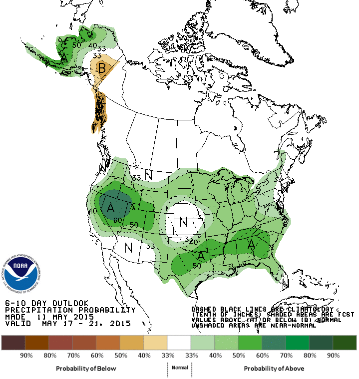
fast if you believe the forecasts. What about after that 5-day period? Well,
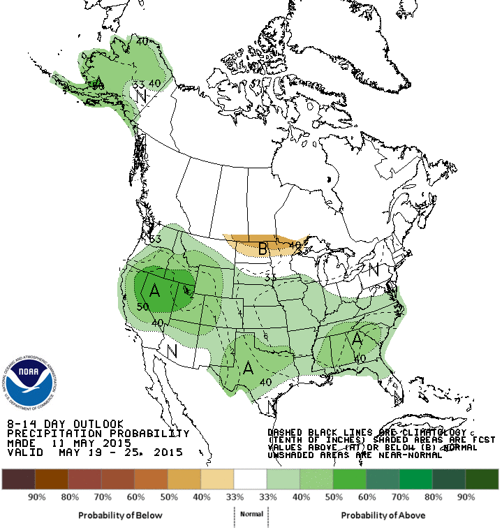
the CPC outlooks are still seeing increased odds of above normal rainfall for
the 17th through the 25th, at least in that general period.
http://ticker.mesonet.org/archive/20150512/may17-21-precip-outlook.gif
http://ticker.mesonet.org/archive/20150512/may19-25-precip-outlook.gif
That looks rather ominous, given that we'll have water stacked high across most
of the state, and even stacked low into the soils. But never fear, this too
shall pass...down all the streams and rivers and eventually into the Gulf of
Mexico. It may look nasty now...a bunch of mud and dirt everywhere. But let's
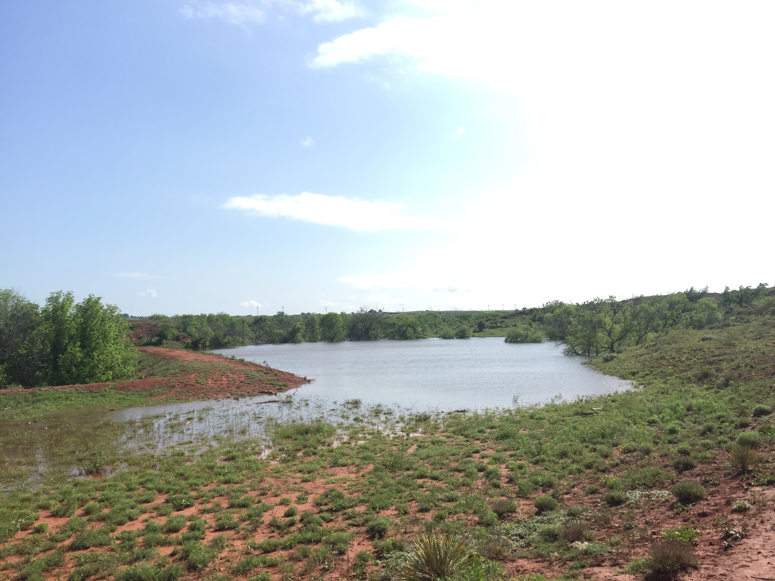
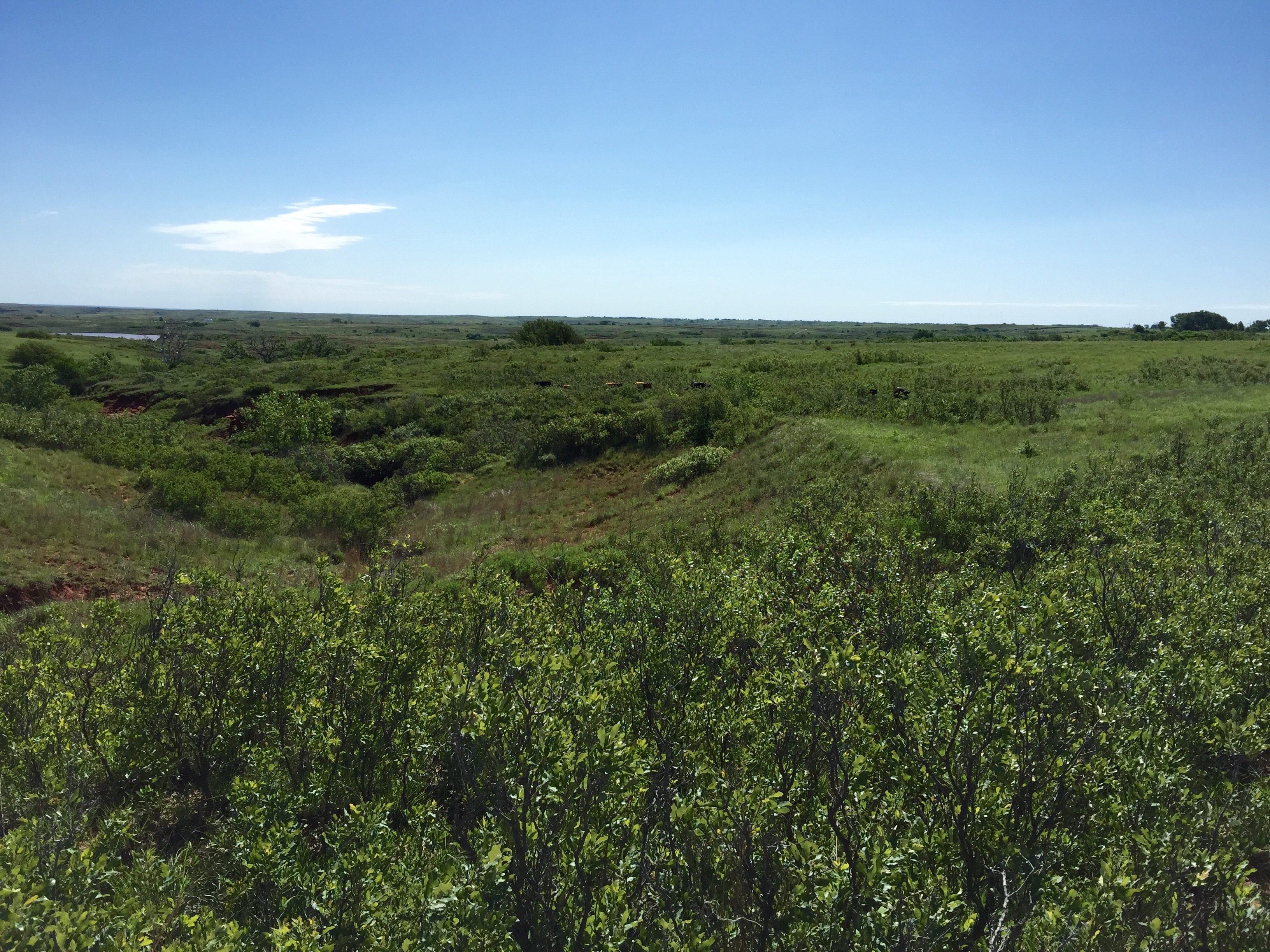
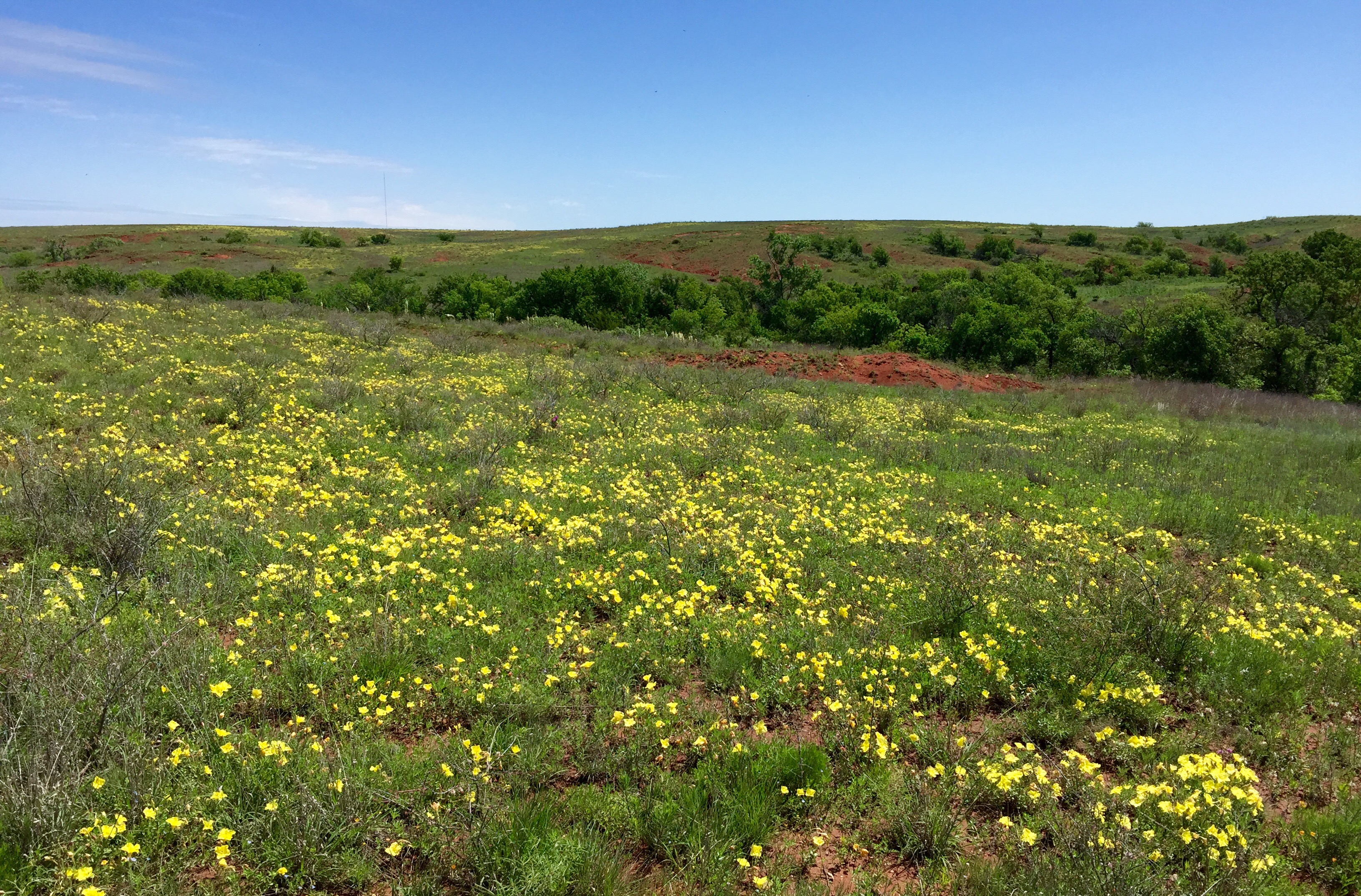
see what it has done for one of the hardest hit areas of the state over the
last 4.5 years, Roger Mills County in far western Oklahoma. Remember they had
their big rains in April. Over 13 inches, in fact. Well, look at that area now.
http://ticker.mesonet.org/archive/20150512/cheyenne1.jpg
http://ticker.mesonet.org/archive/20150512/cheyenne2.jpg
http://ticker.mesonet.org/archive/20150512/cheyenne3.jpg
http://ticker.mesonet.org/archive/20150512/cheyenne4.jpg
To quote the gentleman who sent us these pictures of Ireland?? (no, the Cheyenne
area):
"There's water seeping out of the sides of the canyons everywhere you
look. It's like 1996-98. And we've gone directly from too dry to weld
to too rainy to get anything done. Another good problem to have. We're
completely good around here with seeing the big rain go somewhere else,
especially down around Altus. We're out of space to store any more
runoff."
Sounds good to me! But stay away from my neighborhood too. Altus can have our
share as well!
Gary McManus
State Climatologist
Oklahoma Mesonet
Oklahoma Climatological Survey
(405) 325-2253
gmcmanus@mesonet.org
==================================================
The OCS/Mesonet Ticker
https://ticker.mesonet.org/
To subscribe or unsubscribe from the Ticker
or for questions about the Ticker or its content
Phone or Email the Ticker Manager at OCS
Phone: 405-325-2253 Email: ticker@mesonet.org
---------------------------------------------------
-C- Copyright 2024 Oklahoma Climatological Survey
===================================================
|


 Tweet
Tweet