MESONET TICKER ... MESONET TICKER ... MESONET TICKER ... MESONET TICKER ...
April 26, 2024 April 26, 2024 April 26, 2024 April 26, 2024
Intensify
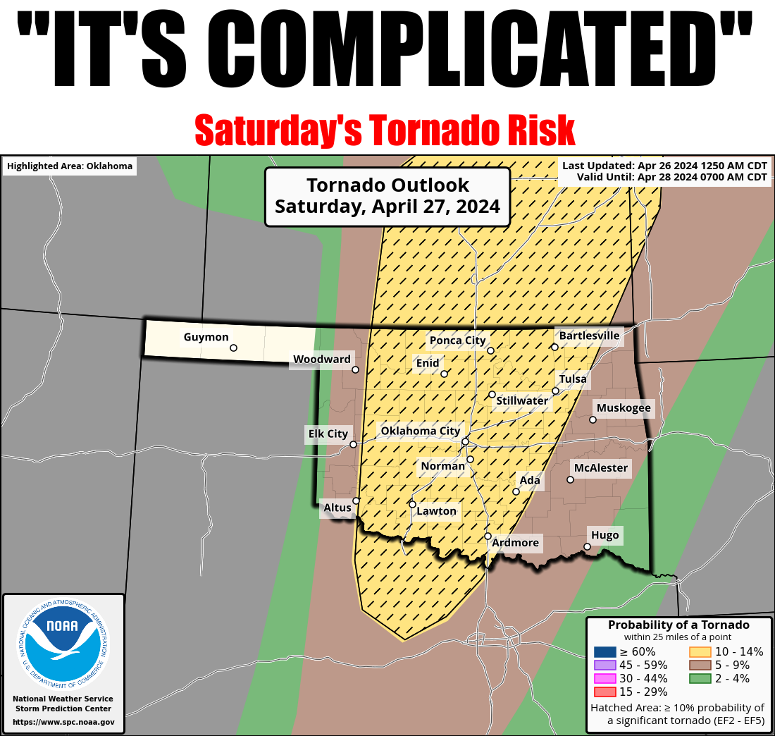
https://ticker.mesonet.org/archive/20240426/OK_swody2_TORN.png
I'm back from D.C., what'd I miss???
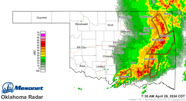
Oh yeah, one of "those" days in Oklahoma. Wind, hail, a few spin-up tornadoes
appeared to have dropped down along that line of storms that is passing through
the state. Storms? Yes, storms. Heck, it's storming right now for crying out
loud!
https://ticker.mesonet.org/archive/20240426/current-radar.png
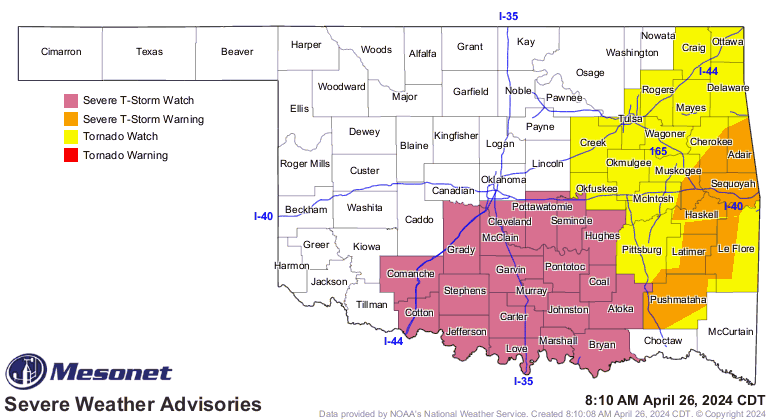
Tornadoes? Yes, tornadoes. Heck, there are tornado AND severe storm watches right
now for crying out loud!
https://ticker.mesonet.org/archive/20240426/latest.oklahoma.severe.gif
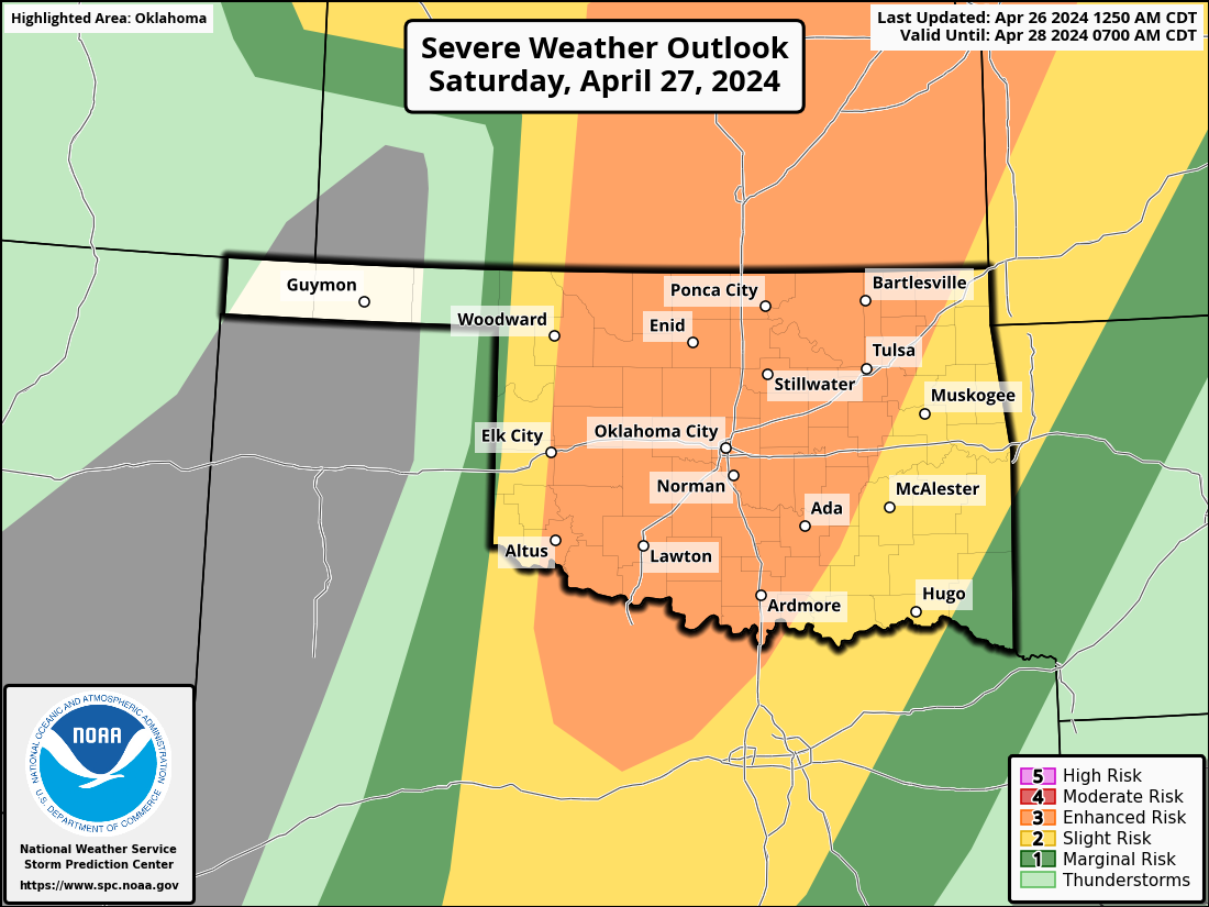
Tornadoes suck. Get it? And there might be quite a bit of suckage tomorrow as we
go through yet another one of "those" days in Oklahoma. You know "those" days,
when you wake up in the morning and check the SPC severe outlooks and you go
back to bed and hope it all just goes away, but doesn't BLOW away?
AFTER your Pop-Tarts*, of course. Gotta have breakfast (*Pop-Tarts are part of
a balanced breakfast...an extremely unhealthy part, but come one!).
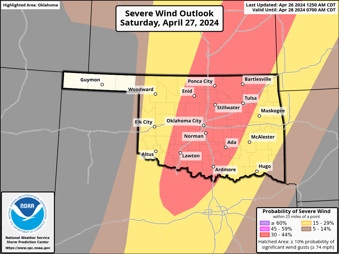
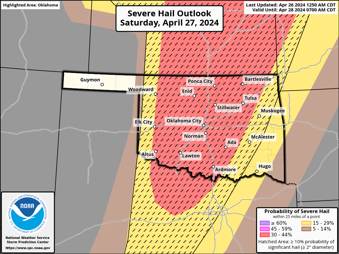
We have several ways to get severe weather tomorrow...along the dryline from
Kansas down through western OK into Texas, along the warm front up north, and
in the warm sector everywhere in between. Oh yeah, along an advancing cold
front, too. Like the graphic says...it's complicated, but also pretty simple.
Just get and remain prepared throughout the day tomorrow.
https://ticker.mesonet.org/archive/20240426/OK_swody2.png
https://ticker.mesonet.org/archive/20240426/OK_swody2_WIND.png
https://ticker.mesonet.org/archive/20240426/OK_swody2_HAIL.png
Morning convection (and we all know just how painful that can be) could foul
things up, so let's hope for that. Even so, there appears to be enough recovery
during the day to really set things off, regardless of any chances of those
morning showers/storms lessening the instability later that day. SPC mentions
that those dryline storms could produce "strong to intense tornadoes..." for
any supercells that go up and persist.
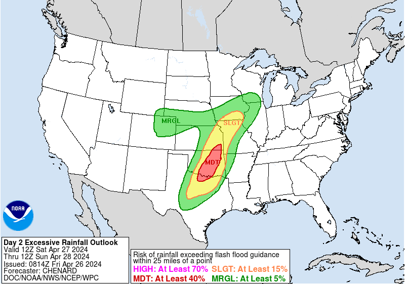
Don't forget the flooding risk, either, where we see at least a 40% risk of
flash flooding broadly centered across the I-35 corridor tomorrow, where 3-4
inches of rain could fall with training storms.
https://ticker.mesonet.org/archive/20240426/sat-flood-risk.gif
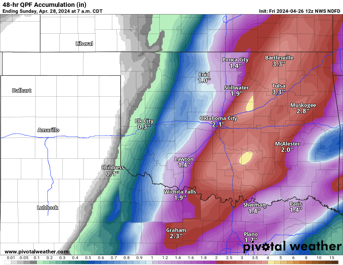
https://ticker.mesonet.org/archive/20240426/48hour-rain-forecast.png
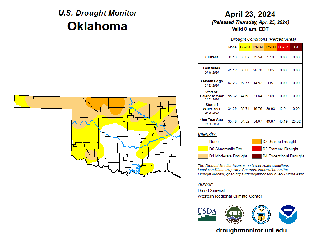
This all occurs along the backdrop of a strengthening flash drought across much
of the state, where we now have more than 35% of the state BACK in drought,
after having it down to just 3% about a month ago.
For crying out loud indeed!
https://ticker.mesonet.org/archive/20240426/20240423_ok_trd.png
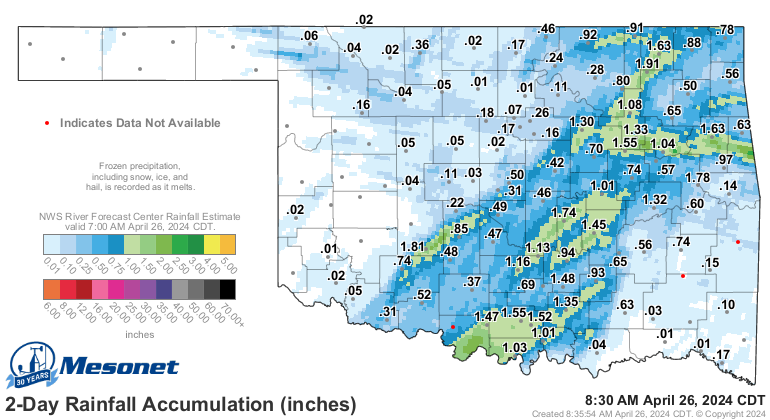
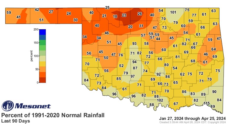
We've gotten some pretty good rains with these storms.
Just. Not. Everywhere. We. Need. It.
https://ticker.mesonet.org/archive/20240426/rainrfc.48hr.png
https://ticker.mesonet.org/archive/20240426/mesonet.rainfall.quarterinch.png
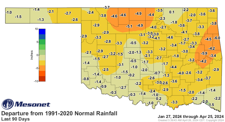
https://ticker.mesonet.org/archive/20240426/del90day_rain.current.png
https://ticker.mesonet.org/archive/20240426/pct90day_rain.current.png
Back to the main threat...once those storms move out of your area this morning,
regroup and recalibrate. Just drop in and see what condition your condition
is in. Then, wake up tomorrow and start planning for severe weather all over
again. Tune into your local NWS office as well as your favorite media source.
No, not your Aunt Myrtle's cows. Not your Uncle Delbert's aching knees. A
respected source.
While that leaves the Ticker out as well, listen to us today and believe us
tomorrow.
Panhandle...sorry, you're out of luck again on the rain, so you get to be FIRE
aware.
https://ticker.mesonet.org/archive/20240426/OK_fwody2.png
Yeesh!
Gary McManus
State Climatologist
Oklahoma Mesonet
Oklahoma Climatological Survey
gmcmanus@mesonet.org
==================================================
The OCS/Mesonet Ticker
https://ticker.mesonet.org/
To subscribe or unsubscribe from the Ticker
or for questions about the Ticker or its content
Phone or Email the Ticker Manager at OCS
Phone: 405-325-2253 Email: ticker@mesonet.org
---------------------------------------------------
-C- Copyright 2024 Oklahoma Climatological Survey
===================================================
|


 Tweet
Tweet