MESONET TICKER ... MESONET TICKER ... MESONET TICKER ... MESONET TICKER ...
January 30, 2013 January 30, 2013 January 30, 2013 January 30, 2013
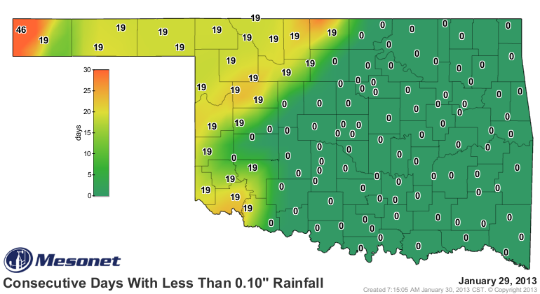
Tally me rainfall amounts
These maps show it almost as well as the actual rainfall maps themselves. You can
tell who got lucky yesterday and who didn't from the "consecutive days without"
Mesonet maps.
http://ticker.mesonet.org/archive/20130130/mesonet.rainfall.tenthinch.png
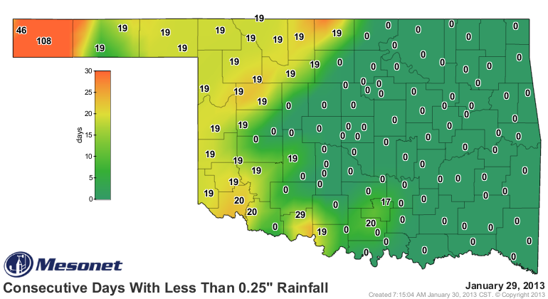
http://ticker.mesonet.org/archive/20130130/mesonet.rainfall.quarterinch.png
Cimarron County in the far western Panhandle is oranged out with the count of
consecutive days without at least a quarter-inch of rain up to 108 (109 counting
today, but who's counting?). But you can also see from both maps that a line
from Medford to Butler back to the southeast to Walters to Waurika, then back
west to the state line ... well, they're looking to the east of that line with
envy. The actual rainfall maps themselves tell the more detailed story, however:
who got drenched (relatively), who got just a bit, etc.
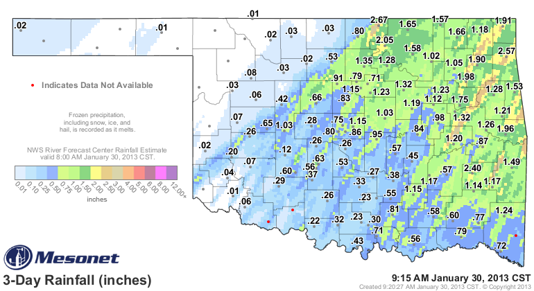
http://ticker.mesonet.org/archive/20130130/rainrfc.72hr.png
You can clearly see those tendrils of heavier rainfall running from southwest to
the northeast as the storms formed along the front and moved to the northeast
while the entire line moved slowly to the east. Those in between those lines
were also less fortunate. For instance, notice Norman with 0.26 inches while
west OKC received 0.80 inches and Spencer totaled 0.86 inches. Another
unfortunate area was just to the right of Newkirk, the state's leading bounty-
getter with 2.67 inches. I heard from a Ticker reader that lives a half-mile
to the west of the Newkirk site that they received about a half of an inch.
Sometimes that's just how close it can come to being feast or famine. Seems to
me that the line formed a bit farther west and moved a bit slower than expected.
Those rains brought the monthly total to ABOVE NORMAL! Not a huge deal in
January, especially dealing with the deficits we have, but it's been quite
awhile since that happened - April 2012 to be exact. Since then, of course,
we've dealt with our driest May-December on record (back to 1895), and one of
our driest May-January periods on record, regardless of the above-normal January.
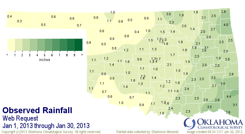
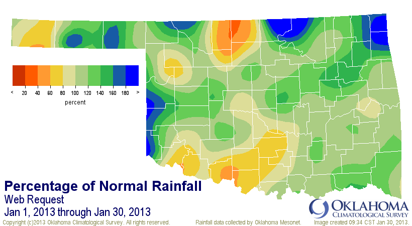
Here are the totals for January thus far. The statewide average rose to 1.61
inches, about 0.2 inches above normal. That's gonna be about somewhere around
the 45th wettest January since 1895. January 2012 was 1.89 inches and the 36th
wettest, FYI.
http://ticker.mesonet.org/archive/20130130/january-2013-tots.png
http://ticker.mesonet.org/archive/20130130/january-2013-pct.png
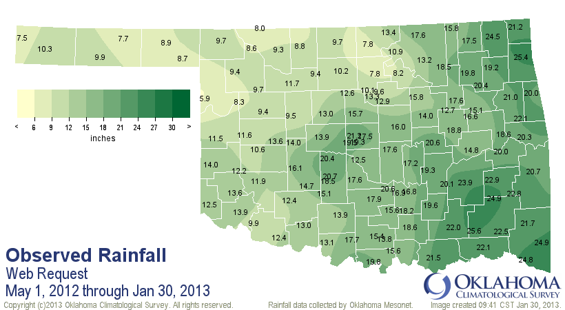
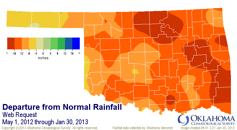
The May 2012-January 2013 total is gonna end up somewhere around 15.5 inches,
I think, which would make it the second driest May-January on record (1910-11)
similar period total of 14.51 inches is driest. Blackwell and Red Rock are still
working with 7.8 inches of rain since May 1. That's about 23 inches below
normal. Arnett's holding pat with 5.9 inches. That's about 15-16 inches below
normal.
http://ticker.mesonet.org/archive/20130130/may2012-jan2013-tots.png
http://ticker.mesonet.org/archive/20130130/may2012-jan2013-deps.png
Now we look for reinforcements (for those that got it...for those that didn't,
we're just looking for anything). Next rain chance looks to be about a week
away. We'll see if it fortifies in the next few days.
Gary McManus
Associate State Climatologist
Oklahoma Climatological Survey
(405) 325-2253
gmcmanus@mesonet.org
==================================================
The OCS/Mesonet Ticker
https://ticker.mesonet.org/
To subscribe or unsubscribe from the Ticker
or for questions about the Ticker or its content
Phone or Email the Ticker Manager at OCS
Phone: 405-325-2253 Email: ticker@mesonet.org
---------------------------------------------------
-C- Copyright 2024 Oklahoma Climatological Survey
===================================================
|


 Tweet
Tweet