MESONET TICKER ... MESONET TICKER ... MESONET TICKER ... MESONET TICKER ...
January 31, 2013 January 31, 2013 January 31, 2013 January 31, 2013
January Defies Dry Trend
January seemed destined to finish on the dry side of normal, just as the eight
months previous to it had, before a late-month burst of spring changed its
fortunes. Tornado watches covered much of the eastern two-thirds of the state on
the 29th, a by-product of the storm system that also dumped 1-3 inches of rain
across parts of that same area. There were no confirmed tornadoes in Oklahoma,
but reports of large hail and wind damage were scattered across the state. The
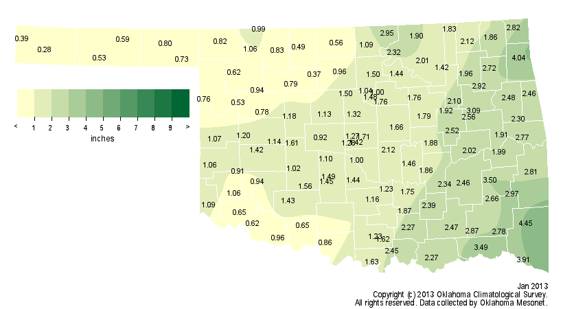
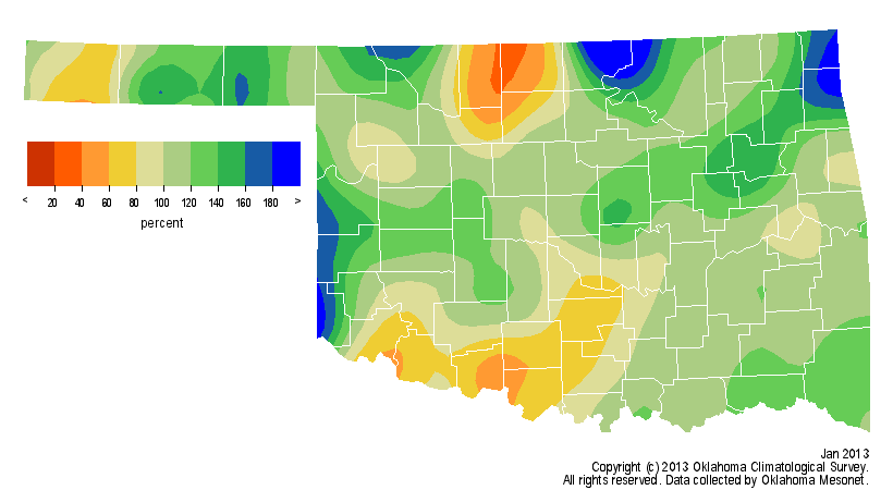
late-month frenzy from Mother Nature brought January?s precipitation total 0.2
inches above normal and a final statewide average of 1.6 inches according to data
from the Oklahoma Mesonet. That ranks the month as the 45th wettest January since
records began in 1895, and the first month since April 2012 to finish with above
normal precipitation. Not all areas of the state were so fortunate. Parts of
western Oklahoma finished the month with less than an inch of rainfall.
http://ticker.mesonet.org/archive/20130131/january-totals.png
http://ticker.mesonet.org/archive/20130131/january-percent.png
Combined with December, the first two months of winter finished 0.9 inches
below normal at 2.5 inches, the 39th driest December-January period on record.
Coming off the driest May-December on record for the state, the May-January
statewide average of 15.4 inches ranked as the third driest such period on
record, behind similar periods in 1910-11 (14.5 inches) and 1952-53 (15.2
inches).
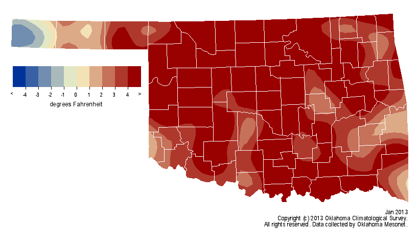
To the delight of some and the chagrin of cold-weather enthusiasts, January?s
temperatures did continue a trend. The month became the 28th out of the last
34 to finish warmer than normal, a rarely-interrupted streak that began with
April 2010. Included in that streak are the warmest month (July 2011) and
summer (2011) for any state on record, the warmest Oklahoma spring (2012) on
record, and the warmest Oklahoma year (2012) on record. According to
preliminary data from the Oklahoma Mesonet, the statewide average temperature
was 40 degrees, 3.9 degrees above normal and the 28th warmest January on record.
http://ticker.mesonet.org/archive/20130131/january-tavg.png
http://ticker.mesonet.org/archive/20130131/january-departure.png
Despite the lofty ranking, there were still a few bouts with frigid weather.
Kenton recorded the state?s lowest temperature for the month at minus 10
degrees on the second. That is the lowest temperature recorded by the Mesonet
since Nowata broke the state?s all-time low temperature record with minus 31
degrees back on Feb. 10, 2011. The highest temperature of the month was 81
degrees, recorded at Grandfield on the 28th. The first two months of winter had
a statewide average temperature of 40.9 degrees, 3.3 degrees above normal and
ranked as the 17th warmest December-January period on record.
The U.S. Drought Monitor ended the month with 92 percent of the state in at
least Extreme (D3) drought, and 37 percent of that in the Exceptional (D4)
category. The Drought Monitor?s intensity scale slides from moderate-severe-
extreme-exceptional, with exceptional being the worst category.
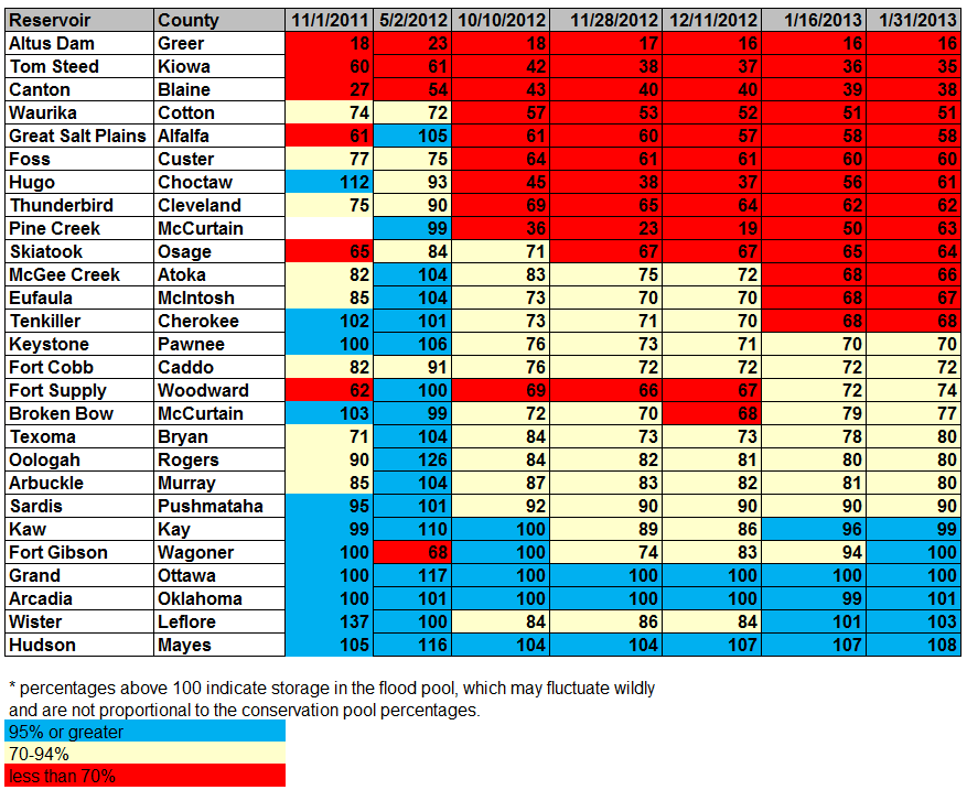
Oklahoma reservoirs, some of which have fallen to historic lows, made some gains
in eastern Oklahoma. Broken Bow Lake in McCurtain County rose to 77 percent of
capacity, a nine percent rise in about a month?s time. Hugo Lake in Choctaw
County rose from 37 percent to 61 percent. The lakes farther to the west still
remain near those historic lows, however. The reservoir at Altus-Lugert
remained at 16 percent of capacity, and nearby Tom Steed Lake hovered at 35
percent. Oklahoma City and Norman have both implemented mandatory water
conservation guidelines to their water customers due to low lake levels.
http://ticker.mesonet.org/archive/20130131/jan31-lake-levels.png
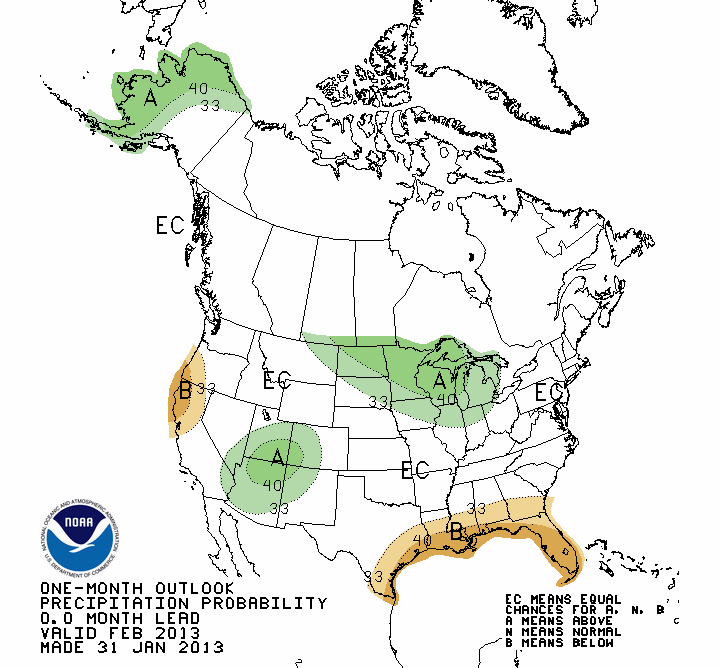
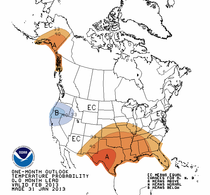
Moisture looks a bit scarce in the short term. Farther out, the latest
temperature outlook for February from the National Weather Service?s Climate
Prediction Center (CPC) indicates increased odds of above normal temperatures
across the entire state. The CPC precipitation outlook points to equal odds of
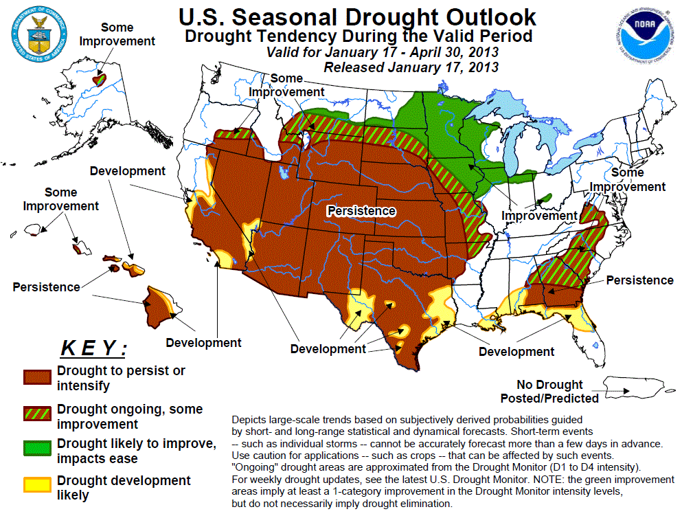
above-, below- or near-normal moisture totals. CPC?s U.S. Seasonal Drought
Outlook for February-April sees drought either persisting or intensifying
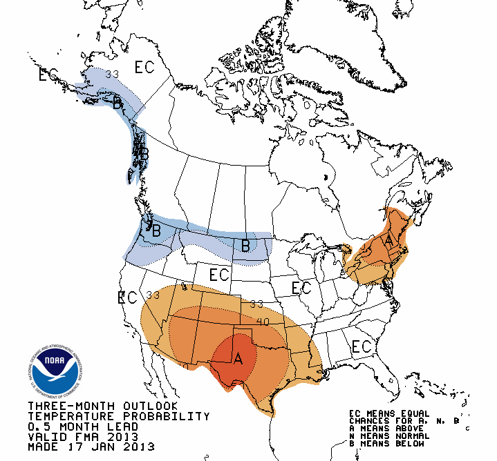
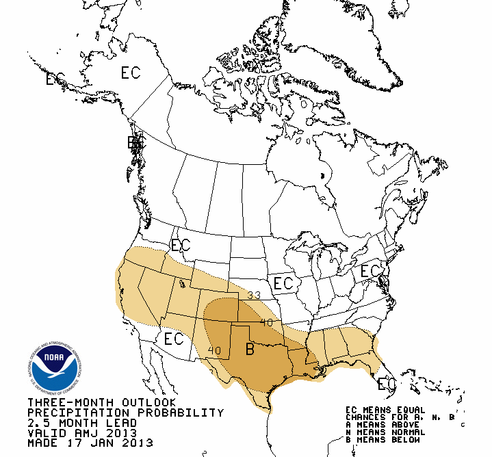
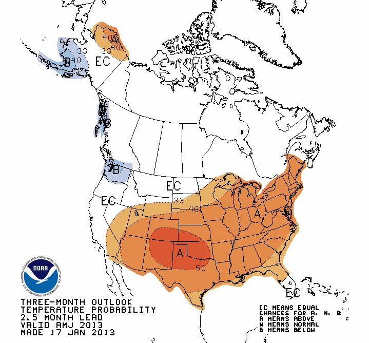
across the entire state. The CPC outlook for the primary rainy season in
Oklahoma, April-June, calls for increased odds of above normal temperatures
and below normal precipitation.
February CPC Outlooks
http://ticker.mesonet.org/archive/20130131/feb-precip.gif
http://ticker.mesonet.org/archive/20130131/feb-temps.gif
February-May Outlooks
http://ticker.mesonet.org/archive/20130117/feb-may-precip.gif
http://ticker.mesonet.org/archive/20130117/feb-may-temps.gif
U.S. Seasonal Drought Outlook
http://ticker.mesonet.org/archive/20130117/season_drought.gif
April-June CPC Outlooks
http://ticker.mesonet.org/archive/20130131/apr-jun-precip.gif
http://ticker.mesonet.org/archive/20130131/apr-jun-temps.gif
Gary McManus
Associate State Climatologist
Oklahoma Climatological Survey
(405) 325-2253
gmcmanus@mesonet.org
==================================================
The OCS/Mesonet Ticker
https://ticker.mesonet.org/
To subscribe or unsubscribe from the Ticker
or for questions about the Ticker or its content
Phone or Email the Ticker Manager at OCS
Phone: 405-325-2253 Email: ticker@mesonet.org
---------------------------------------------------
-C- Copyright 2024 Oklahoma Climatological Survey
===================================================
|


 Tweet
Tweet