MESONET TICKER ... MESONET TICKER ... MESONET TICKER ... MESONET TICKER ...
January 29, 2013 January 29, 2013 January 29, 2013 January 29, 2013
Welcome back, convection!
If you live west of a line from about Altus to Watonga to Blackwell, skip this
Ticker ... it's gonna make your heart hurt (as opposed to everybody else reading,
whose heads will hurt).
But, just like when Hans Gruber told his computer henchman "You ask for miracles,
Theo, I give you the F...B...I!" (I'm about out of "Die Hard" quotes, by the way).
In that vein, you ask for drought relief, I give you thunderstorms! Convection is
our great equalizer to rainfall deficits. We get the bulk of our precipitation
from convection. And yes, it does come with deleterious (wait ... quick check
on dictionary.com ... yes, that is a word, moving on) side effects, as evidenced
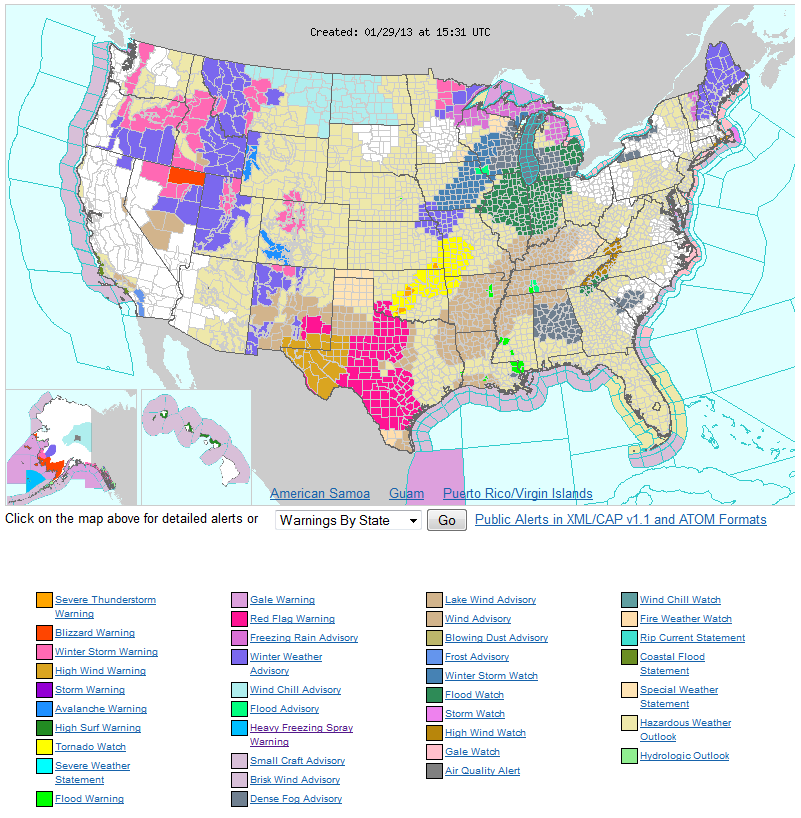
by the two tornado watches issued for Oklahoma by the Storm Prediction Center.
http://ticker.mesonet.org/archive/20130129/nws-advisories.png
Also note that the southwestern part of the state is under a Red Flag Fire warning
for today thanks to high winds and low relative humidity. Since I told those folks
to quit reading, be sure to contact them and tell them that.
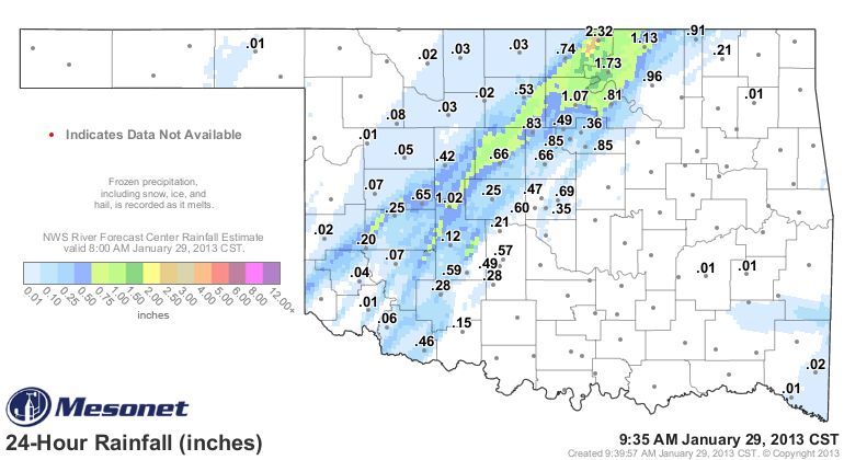
Back to the convection, the squall line that is moving through the state is giving
some folks impressive rainfall totals. Newkirk is the leader thus far with 2.32
inches of rain, at least through 9:35am. That's more rainfall than they've seen
in the last 120 days and beyond! The radar estimates up that way show a wide
area of at least an inch or more of rainfall. Recall that those folks saw the
area of D4 drought expand the last couple of weeks, so it was sorely needed.
http://ticker.mesonet.org/archive/20130129/rainrfc.24hr.png
But this also demonstrates why it is so difficult to forecast precise drought
relief in the spring season (using January as a proxy), when convection is more
prevalent. Deciding where those squall lines form, and more importantly, where
the individual storms within the squall line will continue to form and train
over the same area, is extremely difficult. I can say this, however: it's
more difficult to get training thunderstorms when they DON'T form.
So we gladly accept this bout of moisture for those areas receiving it, and we
now await our next chance of rain about 7-8 days down the road.
Keep track of the Mesonet rainfall totals here:
http://www.mesonet.org/index.php/weather/category/rainfall
That's it. End of Ticker.
(Insert your own "Die Hard" quote here, ... I'm all out. A "Lethal Weapon" quote
can be used as an emergency substitute.)
Gary McManus
Associate State Climatologist
Oklahoma Climatological Survey
(405) 325-2253
gmcmanus@mesonet.org
==================================================
The OCS/Mesonet Ticker
https://ticker.mesonet.org/
To subscribe or unsubscribe from the Ticker
or for questions about the Ticker or its content
Phone or Email the Ticker Manager at OCS
Phone: 405-325-2253 Email: ticker@mesonet.org
---------------------------------------------------
-C- Copyright 2024 Oklahoma Climatological Survey
===================================================
|


 Tweet
Tweet