MESONET TICKER ... MESONET TICKER ... MESONET TICKER ... MESONET TICKER ...
January 2, 2016 January 2, 2016 January 2, 2016 January 2, 2016
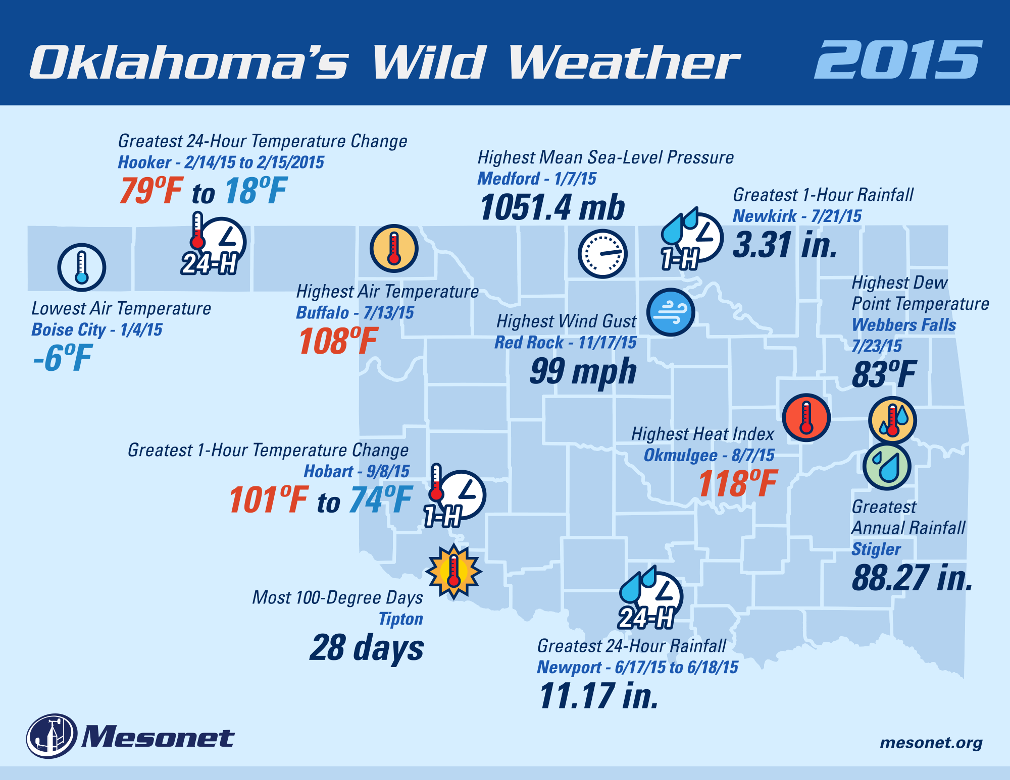
Oklahoma?s Historic 2015 Weather Ends With A Bang
http://ticker.mesonet.org/archive/20160102/2015-mesonet-extremes.png
Mother Nature managed to save some of the worst of 2015?s weather for last, ending
the year with a powerful winter storm that, while significant for western
Oklahoma, was historic for the eastern half of the state. The Dec. 26-28 event
prompted blizzard, ice storm and winter storm warnings for western Oklahoma while
the eastern half was awash in flood-related emergencies. High winds accompanied
the storm throughout its stay. The Oklahoma Mesonet recorded 984 wind gusts of at
least 50 mph from 10 p.m. on Dec. 26 through 4:15 a.m. on Dec. 28. Those high
winds, gusting to more than 70 mph at times, combined with freezing rain and ice
to leave more than 200,000 without power.
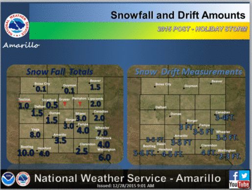
http://ticker.mesonet.org/archive/20160102/nws-amarillo-snow.jpg
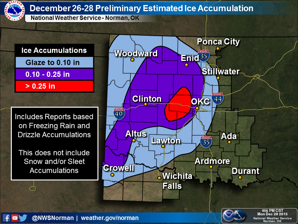
http://ticker.mesonet.org/archive/20160102/nws-norman-ice.jpg
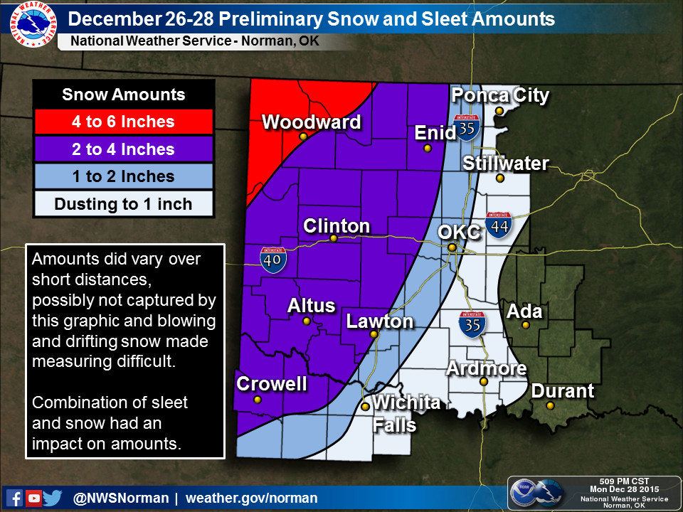
http://ticker.mesonet.org/archive/20160102/nws-norman-snow.jpg
The Oklahoma Dept. of Emergency Management (OEM) reported a preliminary count
of five people having died as a result of the severe weather, with an
additional 104 storm-related injuries.
The Oklahoma Highway Patrol (OHP) reported 955 weather-related collisions,
including 137 injury collisions, according to OEM. The OHP provided 39
motorist assists, including water rescues. The Stranded Motorist Assistance
Recovery Teams assisted approximately 170 motorists from Dec. 26-29.
Flooding was the main concern across eastern Oklahoma where 6-12 inches fell
over the three day period.
http://ticker.mesonet.org/archive/20160102/rainrfc.168hr.png
Numerous roads were closed due to flooding, and floodwaters from dams in
northeast Oklahoma led to evacuation warnings. Widespread catastrophic damage
was reported along the Illinois River basin as the river reached record flood
levels. The river crested at 30.69 feet near Tahlequah on Dec. 28, besting the
previous record from that location of 27.94 feet on May 10, 1950.
The storm was not without other modes of hazardous weather. Numerous tornado
warnings were issued in central and eastern Oklahoma on the 26th, and several
instances of large hail were also reported. Preliminary reports indicate
possible twister touchdowns just to the southeast of the Oklahoma City metro
area, yet to be confirmed by the National Weather Service (NWS). There were two
confirmed tornadoes earlier in the month on Dec. 12 in southeastern Oklahoma.
One of those tornadoes, an EF2 that touched down near Valliant in McCurtain
County, injured three. A total of 109 tornadoes were reported in Oklahoma
during 2015 according to preliminary NWS statistics. That?s the third highest
annual total since accurate records began in 1950. Two deaths and 55 injured
were attributed to tornadoes during 2015.
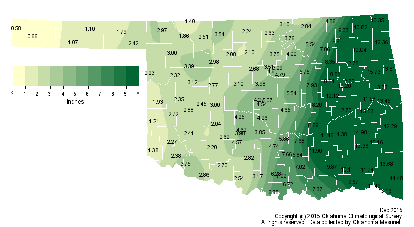
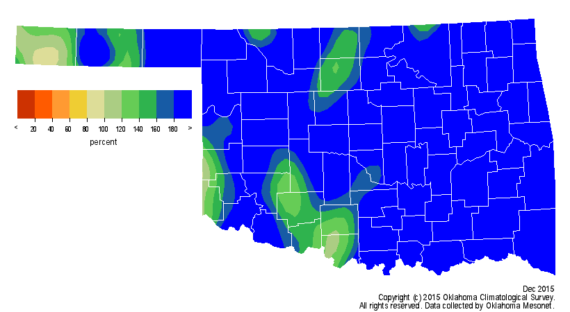
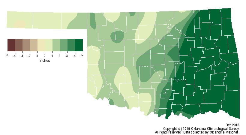
December ended as the wettest on record for the state according to preliminary
statistics from the Oklahoma Mesonet. The statewide average precipitation for
the month was 5.92 inches, 3.86 inches above normal.
http://ticker.mesonet.org/archive/20160102/dec-precip-totals.png
http://ticker.mesonet.org/archive/20160102/dec-precip-pct-normal.png
http://ticker.mesonet.org/archive/20160102/dec-precip-depart-normal.png
The previous record of 4.87 inches was set back in 1984. Those records date
back to 1895. The southeastern and east central climate divisions had
astounding averages of 13.01 inches and 12.39 inches, respectively, both more
than 9 inches above normal and obviously the wettest on record for those
regions. Mt. Herman led the Mesonet with 16.68 inches for the month, and 30 of
the Mesonet?s 120 stations recorded at least 10 inches of rainfall. The highest
total ever recorded during December was 18.13 inches from the NWS cooperative
observing site at Bear Mountain Tower back in 1971. Mt. Herman?s total ranks as
the fifth highest December total on record for the state. The far western
Panhandle stations of Kenton and Boise City were the only locations to record
less than an inch of precipitation with the former having the lowest total at
0.58 inches. Boise City reported 8 inches of snow for the month to bring their
seasonal total to 16 inches, the highest in the state.
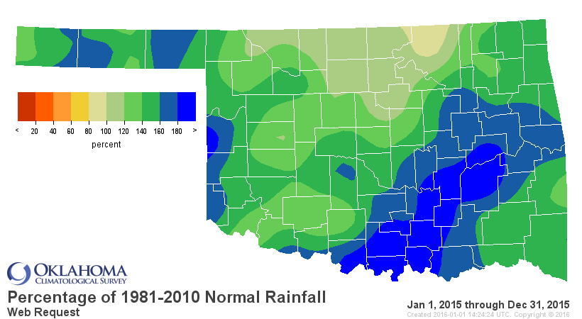
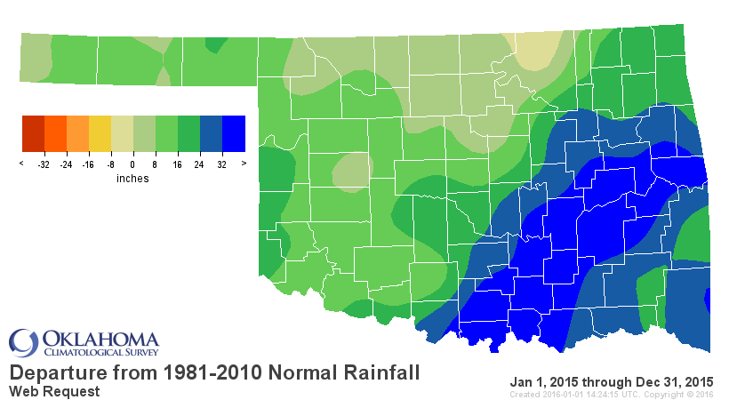
The second wettest November and wettest December on record gave 2015 a final
push past the previous wettest calendar year by half a foot with a preliminary
statewide average of 53.88 inches.
http://ticker.mesonet.org/archive/20160102/2015-precip-totals.png
http://ticker.mesonet.org/archive/20160102/2015-precip-pct.png
http://ticker.mesonet.org/archive/20160102/2015-precip-depart.png
The record prior to 2015 was held by 1957 at 47.88 inches. The new record
obviously came with some equally monumental localized totals. The NWS
cooperative observing station at Daisy in Atoka County blasted past the
previous record for wettest calendar year at any location in the state with
89.69 inches, topping Tuskahoma?s 88.27 inches in 1990. The Mesonet site at
Stigler tied that previous record as well. In all, 12 Mesonet stations and five
NWS cooperative sites topped 80 inches for the year according to preliminary
data. Not surprisingly, Kenton brought up the rear with a total of 21.45 inches,
but that is still more than 6 inches above normal. May captured the record for
wettest month in Oklahoma history with a statewide average of 14.44 inches,
topping October 1941?s 10.75 inches.
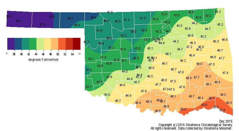
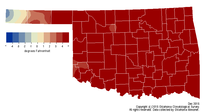
December ended much warmer than normal despite the late-month cool down.
According to preliminary data from the Oklahoma Mesonet, the statewide average
temperature was 44.5 degrees, 5.6 degrees above normal to rank as the fourth
warmest on record.
http://ticker.mesonet.org/archive/20160102/dec-avg-temps.png
http://ticker.mesonet.org/archive/20160102/dec-temps-departure.png
Arnett and Waurika led the state with readings of 80 degrees on December 11,
although high temperatures of at least 60 degrees occurred in the state on 23
of the month?s 31 days. Highs reached at least 70 degrees on 14 days. Several
sites across eastern Oklahoma had a low temperature of 66 degrees on the 12th,
which is about 15 degrees above the normal high temperature for that date.
Idabel led the state with a monthly average temperature of 50.9 degrees, while
Kenton had the lowest at 34.2 degrees. The year finished quite warm with a
statewide average of 61 degrees, 1.1 degrees above normal. That ranks the year
as the 17th warmest on record. The Buffalo and Freedom Mesonet sites reached
108 degrees to earn the year?s highest readings. The lowest temperature of
minus 6 degrees was recorded at Boise City back on January 4. The Okmulgee
Mesonet site recorded a heat index of 118 degrees to earn top prize in that
category.
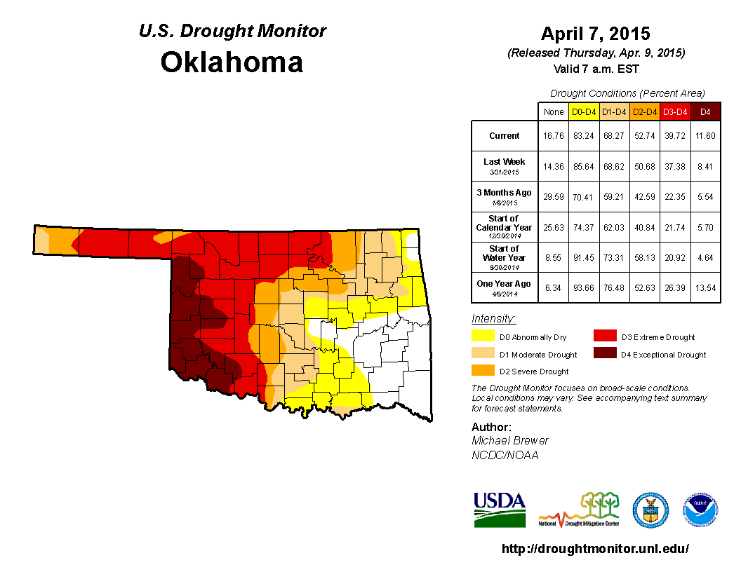
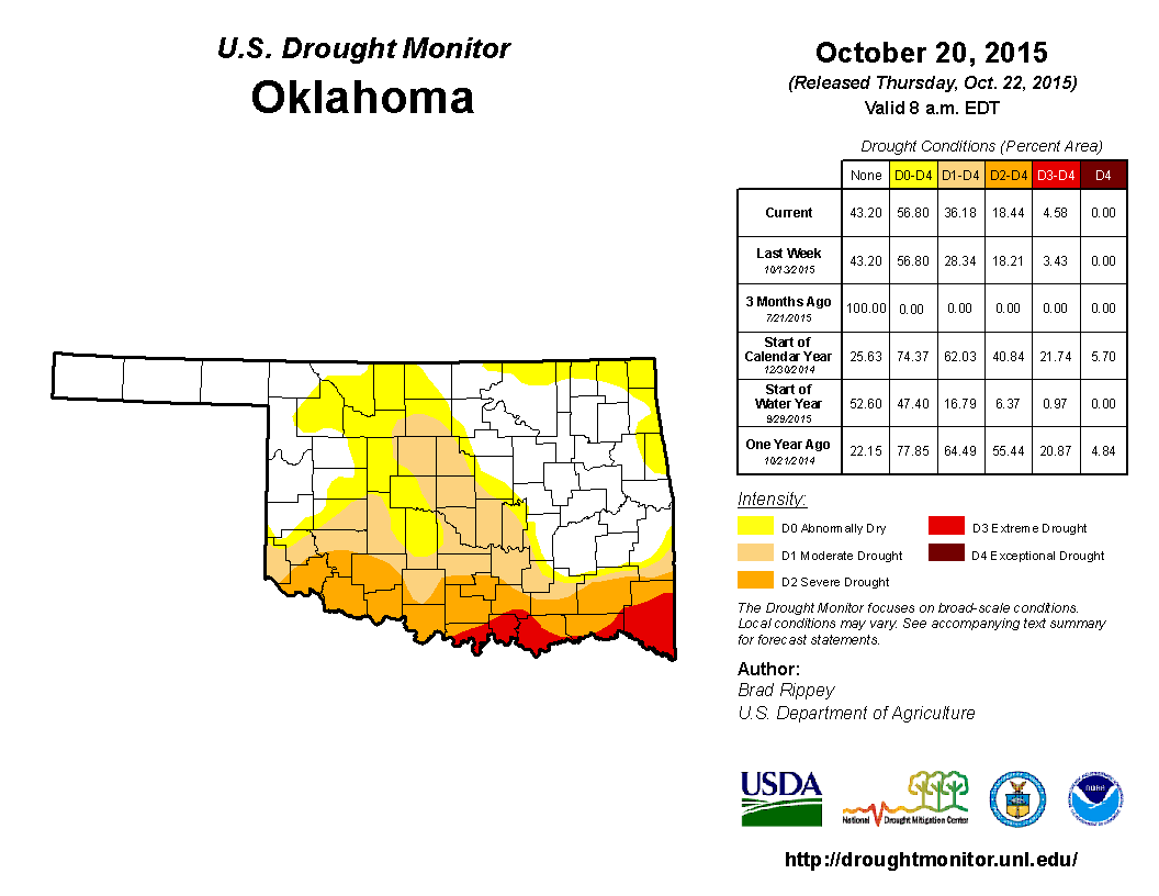
Oklahoma started 2015 with 59 percent of the state in drought according to the
U.S. Drought Monitor, and peaked in early April at 68 percent.
http://ticker.mesonet.org/archive/20160102/april7-drought.monitor.png
At that point, nearly 40 percent of Oklahoma was considered in at least extreme
drought. The Drought Monitor?s intensity scale slides from moderate-severe-
extreme-exceptional, with exceptional being the worst classification. Drought
was completely eradicated by early June, but a dry second half of the summer
brought flash drought back into Oklahoma by early August, peaking once again in
mid-October with 36 percent of the state back in drought.
http://ticker.mesonet.org/archive/20160102/oct20-drought.monitor.png
The dry conditions were once again eradicated by the heavy rains of November
and December.
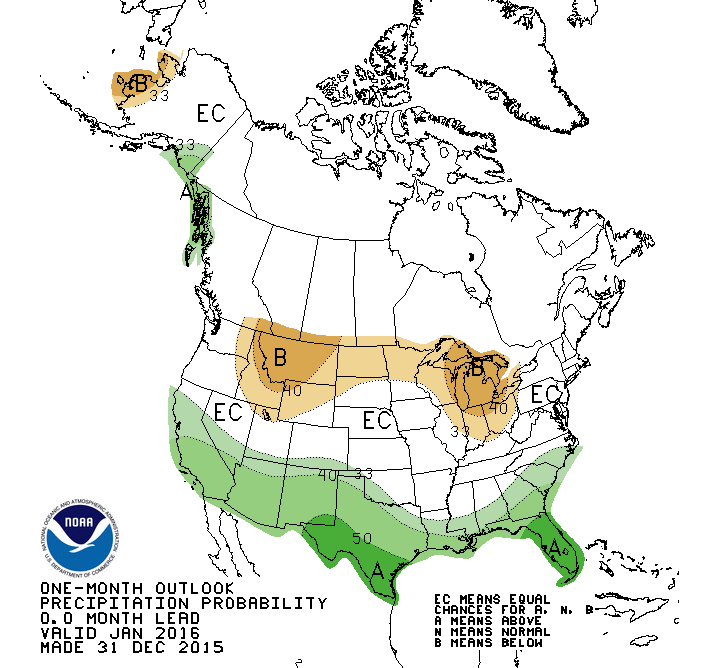
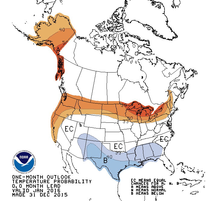
The NWS? Climate Prediction Center (CPC) expects the El Ni?o that is thought to
have impacted both our spring and late fall-early winter weather to remain
strong through winter before dissipating during the spring or early summer of
2016.
http://ticker.mesonet.org/archive/20160102/enso-plume.gif
With that as the backdrop, CPC outlooks call for increased odds of above normal
precipitation across southwestern Oklahoma and the Panhandle during January.
http://ticker.mesonet.org/archive/20160102/january-precip-outlook.gif
http://ticker.mesonet.org/archive/20160102/january-temp-outlook.gif
In the longer term, they see increased odds for above normal precipitation
across most of Oklahoma through mid-spring, with greater chances across the
western half of the state. There are no clear indications in the outlooks for
temperature.
http://www.cpc.ncep.noaa.gov/products/predictions/long_range/
Gary McManus
State Climatologist
Oklahoma Mesonet
Oklahoma Climatological Survey
(405) 325-2253
gmcmanus@mesonet.org
==================================================
The OCS/Mesonet Ticker
https://ticker.mesonet.org/
To subscribe or unsubscribe from the Ticker
or for questions about the Ticker or its content
Phone or Email the Ticker Manager at OCS
Phone: 405-325-2253 Email: ticker@mesonet.org
---------------------------------------------------
-C- Copyright 2024 Oklahoma Climatological Survey
===================================================
|


 Tweet
Tweet