MESONET TICKER ... MESONET TICKER ... MESONET TICKER ... MESONET TICKER ...
January 2, 2014 January 2, 2014 January 2, 2014 January 2, 2014
Frosty December Closes Out Tumultuous 2013
A frigid and sometimes icy December seemed a fitting way to close out the
boisterous weather of 2013. Preliminary data from the Oklahoma Mesonet ranked the
month as the 17th coolest December on record at nearly 4 degrees below normal.
Records of this type for Oklahoma date back to 1895. The statewide average
temperature as recorded by the Mesonet was 35.2 degrees. As chilly as it seemed,
however, that mark provided little threat to 1983's record cold of 25.8 degrees,
but also far cooler than 2012's 42.1 degrees.
http://ticker.mesonet.org/archive/20140102/avgtavg.png
http://ticker.mesonet.org/archive/20140102/deltavg.png
There were two significant winter storms during December, each creating headaches
for travelers and power utility companies. The first storm struck on December 5-6
in two separate waves and brought freezing rain, sleet and snow across the state.
Significant snow totals of 5-6 inches fell from southwestern up through central
Oklahoma, with lesser amounts surrounding that narrow swath. Heavy sleet and
freezing rain created havoc across southern Oklahoma, particularly in Choctaw
and Pushmataha counties where Oklahoma National Guard units were deployed to
help with timber debris removal. More than 9000 homes and businesses were left
without power from this storm. State emergency management officials noted more
than 800 storm related injuries reported by local hospitals, as well as at
least 10 fatalities.
http://ticker.mesonet.org/archive/20131209/storm-totals.jpg
http://ticker.mesonet.org/archive/20131209/tulsa-nws-accumulations.png
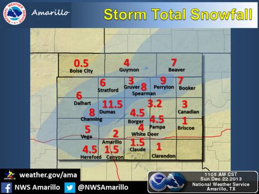
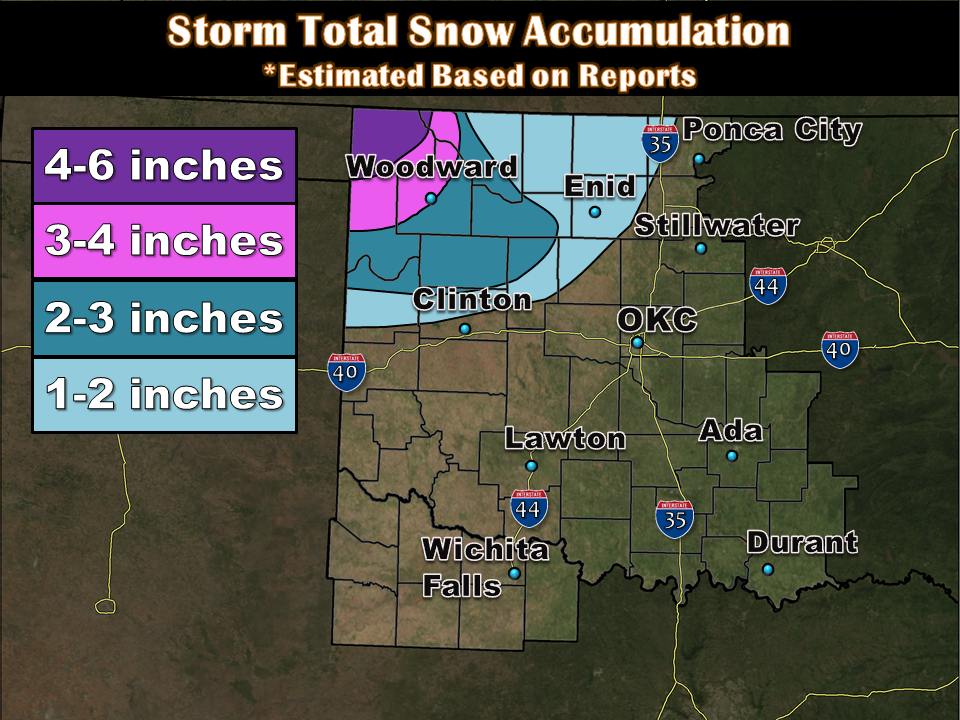
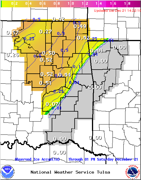
The second storm on December 20-22 was more of an ice event for much of the
state, although significant snow did fall in some areas. Total ice
accumulations of a half-inch to an inch covered much of southwestern through
northeastern Oklahoma along the I-44 corridor. Snow totals from 2-6 inches fell
across far northwestern Oklahoma. Power outages peaked at close to 50,000 homes
and businesses due to ice accumulations on trees and power lines.
http://ticker.mesonet.org/archive/20131223/nws-amarillo-snow-accums.jpg
http://ticker.mesonet.org/archive/20131223/nws-norman-ice-accums.png
http://ticker.mesonet.org/archive/20131223/nws-norman-snow-accums.png
http://ticker.mesonet.org/archive/20131223/nws-tulsa-ice-accums.png
The winter storms provided the southeastern two-thirds of the state with decent
moisture, although much of drought-plagued western Oklahoma remained
significantly dry. The statewide average precipitation total from the Mesonet
was 1.53 inches, about a half-inch below normal, to rank as the 59th wettest
December on record. That total is possibly an underestimate due to the frozen
precipitation, although the moisture pattern across various parts of the state
was quite clear. Far southeastern Oklahoma received from 3-5 inches during the
month while western areas of the state received less than a half-inch, in
general.
http://ticker.mesonet.org/archive/20140102/totrain.png
http://ticker.mesonet.org/archive/20140102/pctrain.png
http://ticker.mesonet.org/archive/20140102/delrain.png
The cold December propelled 2013's statewide average annual temperature to a
mark of 58.9 degrees, 0.8 degrees below normal and the 27th coolest calendar
year on record for the state. That mark stands in stark contrast to 2012's
record warm year of 63.1 degrees. The highest temperature recorded by the
Mesonet during 2013 was 111 degrees at Freedom on June 27. Kenton recorded the
Mesonet's lowest temperature with a reading of -10 degrees on January 2.
http://ticker.mesonet.org/archive/20140102/2013-avgtavg.png
http://ticker.mesonet.org/archive/20140102/2013-deltavg.png
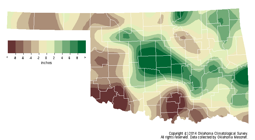
The annual average precipitation total came in at 37.01 inches, 0.32 inches
above normal to rank as the 36th wettest year on record. That total was
certainly not representative of how each region of the state fared, however.
The tallies ranged from 50-60 inches across portions of central through eastern
Oklahoma, to 15-20 inches across far western Oklahoma. Central Oklahoma
received an average of 44.65 inches to rank as the 11th wettest year on record
for that region. Oklahoma City itself finished at 52.78 inches for its second
wettest year on record, dating back to 1891 ? only 2007 was wetter at 56.95
inches. Meanwhile, the Mesonet site at Goodwell recorded a meager 12.8 inches
for the year, the state's lowest annual total. Goodwell's driest year on record
is 9.16 inches from 1952. Mt. Herman led all Mesonet sites with 60.8 inches.
http://ticker.mesonet.org/archive/20140102/2013-rain-totals.png
http://ticker.mesonet.org/archive/20140102/2013-delrain.png
The state's drought picture improved during December in some areas thanks to
the wintry precipitation, but other areas saw drought intensify. Over 38
percent of the state was classified in at least moderate drought at the end of
the month according to the U.S. Drought Monitor, an increase of approximately
eight percent during December. Most of that increase occurred in west central
and northwestern Oklahoma.
http://ticker.mesonet.org/archive/20140102/20131231_OK_trd.png
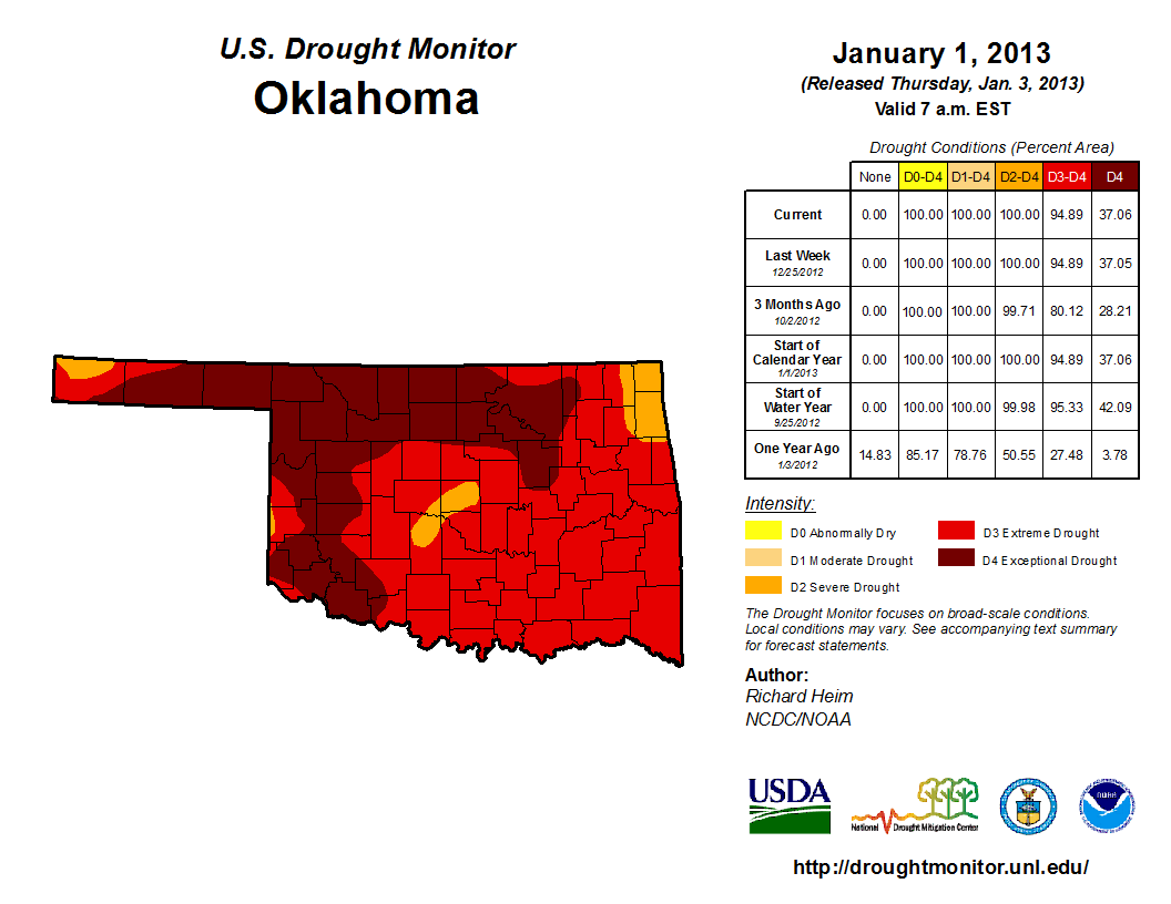
The relief throughout 2013 was much more widespread and significant, however.
At the start of the year, the entire state was covered by at least severe
drought, with 95 percent of that in the extreme-exceptional category. The
Drought Monitor?s intensity scale slides from moderate-severe-extreme-
exceptional, with exceptional being the worst classification.
http://ticker.mesonet.org/archive/20140102/20130101_ok_trd.png
Most of the drought reduction throughout the year occurred in the eastern two-
thirds of the state. Unfortunately, much of far southwestern Oklahoma and the
Panhandle have remained in significant drought for more than three years. Altus'
main water supply reservoir, Tom Steed Lake, was approximately 13 feet below
normal at year's end. The Jackson County city has been under emergency water
conservation orders since early May. Even farther north in Blaine and Dewey
counties, Canton Lake is also approximately 13 feet below normal. Oklahoma
Governor Mary Fallin declared a drought emergency for Jackson, Tillman, Greer,
Harmon and Texas counties in October 2013.
Oklahoma's preliminary tornado count for 2013 stands at 79 according to the
National Weather Service (NWS), although that number could increase as more
tornado reports are investigated. Of the 79 twisters, 56 occurred between May
19 and May 31. Included in that total is the violent EF5 tornado that tore
through McClain and Cleveland counties from Newcastle to east Moore. That
tornado killed 23, including seven third-grade students at Plaza Towers
Elementary in the Moore school district. Another massive tornado struck
Canadian County on May 31. Reportedly the widest in recorded history at more
than 2.6 miles across, that tornado killed eight and injured hundreds of others.
It was once classified as an EF5 due to radar-measured winds of nearly 300 mph
before later being downgraded to an EF3 in the absence of EF5 damage indicators.
Tornadoes killed 34 people during 2013, the most in the state since 1999's 42.
Unfortunately, the weather-related fatalities were not confined to tornadoes.
Flash flooding killed 15 others across the state during 2013, and there were
several other deaths attributable both directly and indirectly to severe winter
weather late in the year.
Prospects for January 2014 and beyond are unclear according to the NWS' Climate
Prediction Center (CPC). CPC notes equal chances for above-, below- and near-
normal temperatures and precipitation across the state for January.
http://ticker.mesonet.org/archive/20140102/off15_prcp.gif
http://ticker.mesonet.org/archive/20140102/off15_temp.gif
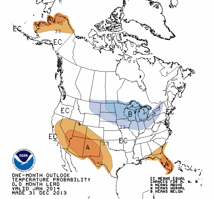
An outlook for January-March released in mid-December did note increased odds
for above normal temperatures across all of Oklahoma for that period.
http://ticker.mesonet.org/archive/20140102/off01_temp.gif
CPC's U.S. Monthly Drought Outlook for January notes drought persisting across
those areas of the state where it currently exists, but no development across
other areas of the state. The seasonal outlook for mid-December through the end
of March indicated similar drought prospects for the state.
http://ticker.mesonet.org/archive/20140102/month_drought.png
http://ticker.mesonet.org/archive/20140102/season_drought.png
Gary McManus
State Climatologist
Oklahoma Climatological Survey
Work: (405) 325-2253
Cell: (405) 823-9054
gmcmanus@mesonet.org
==================================================
The OCS/Mesonet Ticker
https://ticker.mesonet.org/
To subscribe or unsubscribe from the Ticker
or for questions about the Ticker or its content
Phone or Email the Ticker Manager at OCS
Phone: 405-325-2253 Email: ticker@mesonet.org
---------------------------------------------------
-C- Copyright 2024 Oklahoma Climatological Survey
===================================================
|


 Tweet
Tweet