MESONET TICKER ... MESONET TICKER ... MESONET TICKER ... MESONET TICKER ...
January 6, 2014 January 6, 2014 January 6, 2014 January 6, 2014
Remember February 10, 2011??
http://ticker.mesonet.org/archive/20140106/zero.jpg
As I was driving my kids to school this morning up in Moore, one of my daughters
said "Daddy, how much longer 'til winter is over? I'm tired of winter." You and
me both, sister!! Mother Nature's foolishness this morning puts the icing on that
cake with the coldest weather some parts of the state have seen since the
infamous deep freeze of February 10, 2011. Let's take a look at some of the
maps from this morning to see just how cold it got (and felt!).
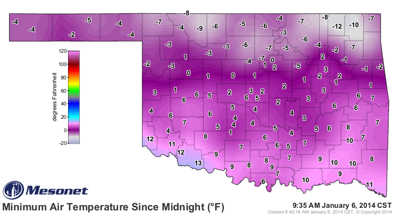
The lowest actual air temperature recorded by the Mesonet was -12 degrees,
fittingly in Nowata, since that's the lowest temperature recorded by the Mesonet
since February 10, 2011, as mentioned previously (on that day, Nowata broke the
all-time record low temperature for the state with -31 degrees). We probably saw
a few low temperature records fall this morning across the state as well.
http://ticker.mesonet.org/archive/20140106/todays-lows.png
http://ticker.mesonet.org/archive/20140106/jan6-record-lows.png
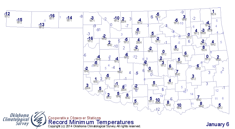
That -12 reading at Nowata tied for the 7th lowest temperature ever recorded on
January 6 for the state, with records going back to the 1880s. From the top-10
list, looks like 1912 and 1971 both had pretty miserable January 6s. Here's
the Top-10 list for lowest temperatures ever recorded in Oklahoma on January 6.
-***-
Rank Low T Location Year
1 -16 ARNETT 3NE 1912
1 -16 HOOKER 1971
3 -15 BOISE CITY 2 E 1912
4 -14 BEAVER 1971
5 -13 GOODWELL RSCH STN 1912
5 -13 HOOKER 1912
7 -12 NOWATA MESONET 2013
7 -12 BEAVER 1912
7 -12 KENTON 1912
10 -11 KENTON 1971
10 -11 WOODWARD 1912
-****-
For fond memories, here's that low temperature map from February 10, 2011.
http://ticker.mesonet.org/archive/20140106/February11-2011-lows.png
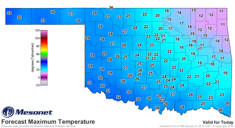
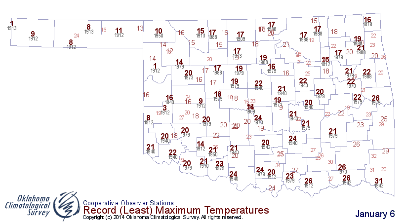
Now we look forward to this afternoon and wonder if many record low maximum
temperature records will fall as well. Here's the forecast highs from the NWS
along with the record low highs for the day as well. Most records look safe,
except for maybe up in the far northeast where lots of snow remains on the
ground.
http://ticker.mesonet.org/archive/20140106/monday-forecast-highs.png
http://ticker.mesonet.org/archive/20140106/jan6-record-low-tmax.png
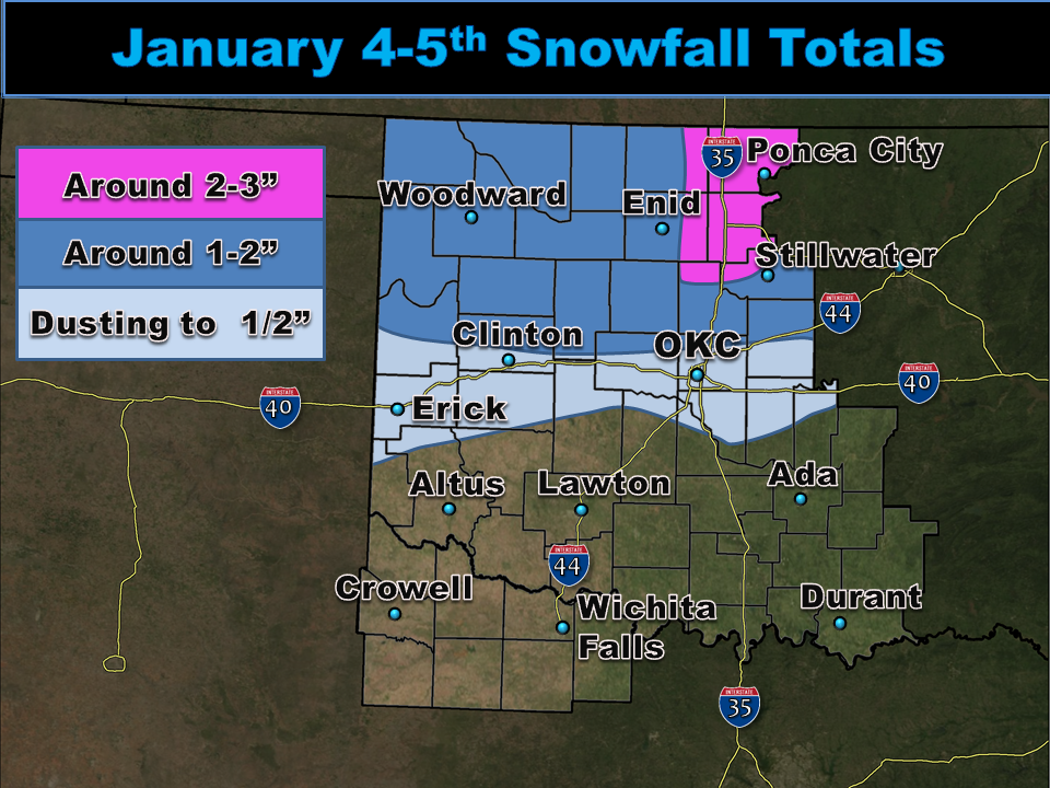
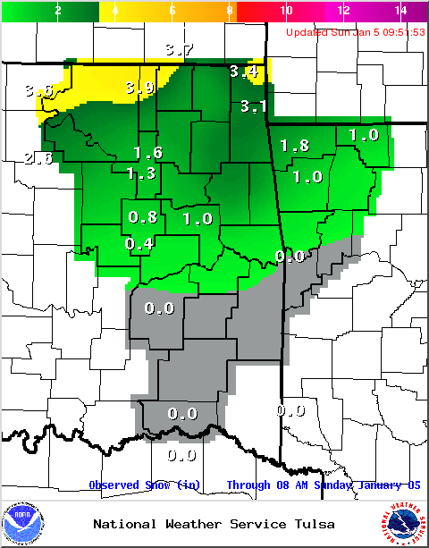
Here are those snow total estimates, at least from the Tulsa and Norman NWS
offices. I think the Panhandle received an inch or two at most.
http://ticker.mesonet.org/archive/20140106/snow-totals-norman.png
http://ticker.mesonet.org/archive/20140106/snow-totals-tulsa.png
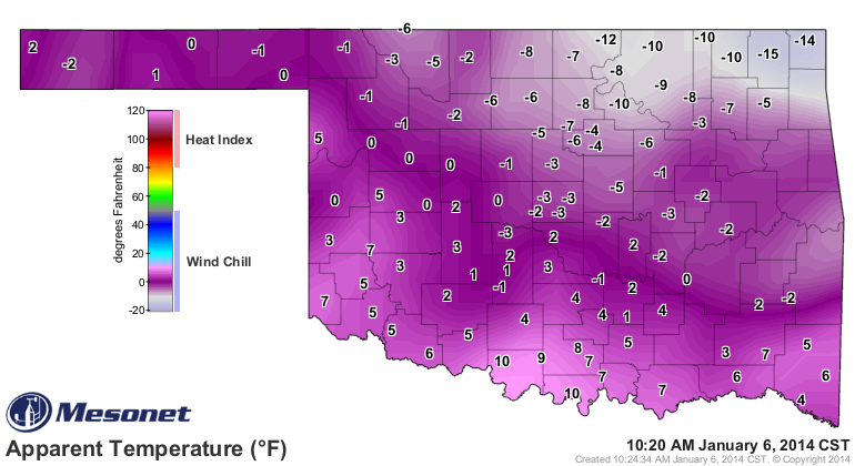
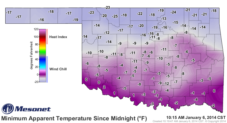
To heck with the actual air temperatures. If you have to go out in it, the wind
chills (apparent temperature) are no cakewalk either. The lowest wind chill
calculated by the Mesonet this morning was -25 degrees up at Alva, but we
had readings below zero across virtually the entire state (some are not showing
up across eastern Oklahoma due to frozen wind sensors). Here are the lowest
wind chills this morning and what they are now.
http://ticker.mesonet.org/archive/20140106/current-wind-chills.png
http://ticker.mesonet.org/archive/20140106/todays-lowest-windchills.png
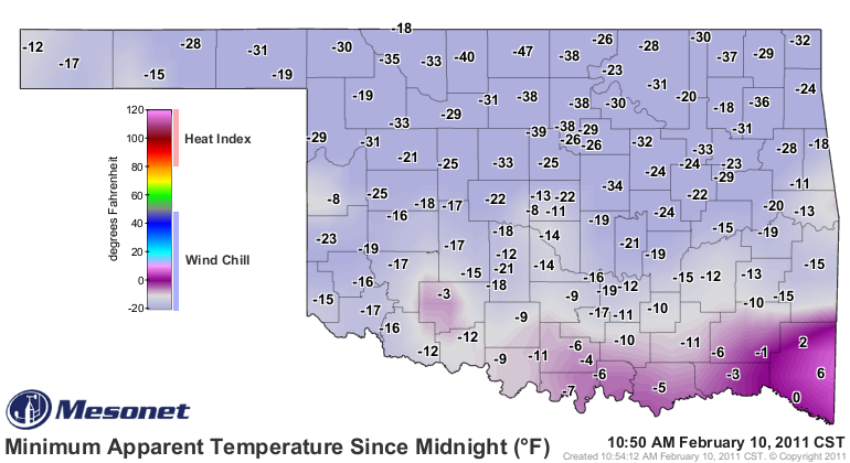
To continue with the unwanted benchmarks, that -25 degrees up in Alva is the
lowest wind chill calculated by the Mesonet since ... yep, you guessed it,
February 10, 2011. Here's the lowest wind chill map from that day for
comparison. Nowhere close to the -47 degrees at Medford that day, thank
goodness.
http://ticker.mesonet.org/archive/20110210/today.TAPP.min.grad.png
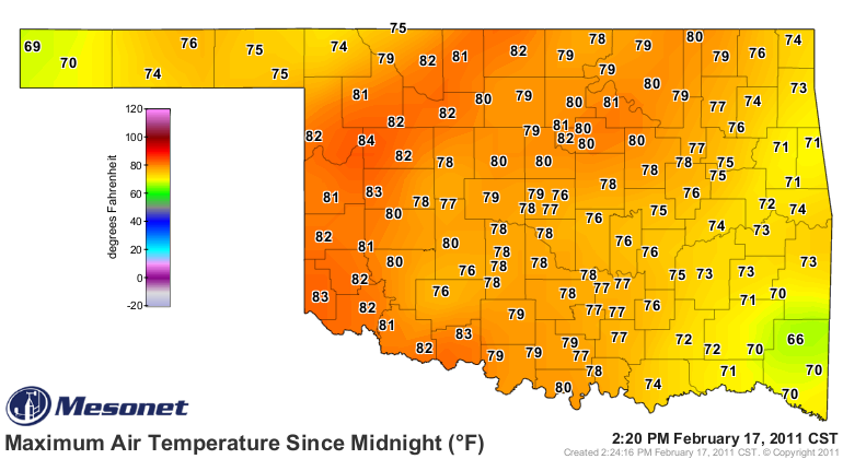
Okay, now let's give you some hope. There IS always hope, after all. Remember
that February 10, 2011, low temperature map? here's the high temperature map a
mere seven days later! I'll even throw in the low temperature map from that day
(February 17, 2011) as well, since we were breaking records for highest minimum
temperatures that morning.
http://ticker.mesonet.org/archive/20110217/today.tmax.png
http://ticker.mesonet.org/archive/20110217/today.TAIR.min.grad.png
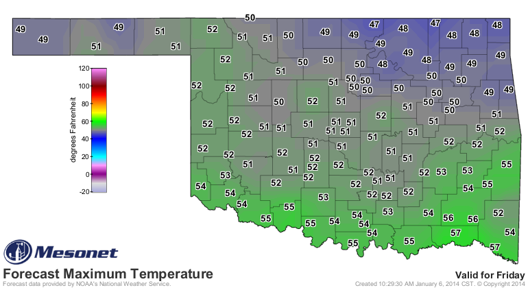
So again, that's how quickly it can change here in the Great Plains. Now I'm not
saying we're going to be seeing any 70s and 80s in seven days, but we are at
least forecast to get back into respectable territory with some 50s by Friday
according to the NWS. That warmth is forecast to last through the weekend as
well.
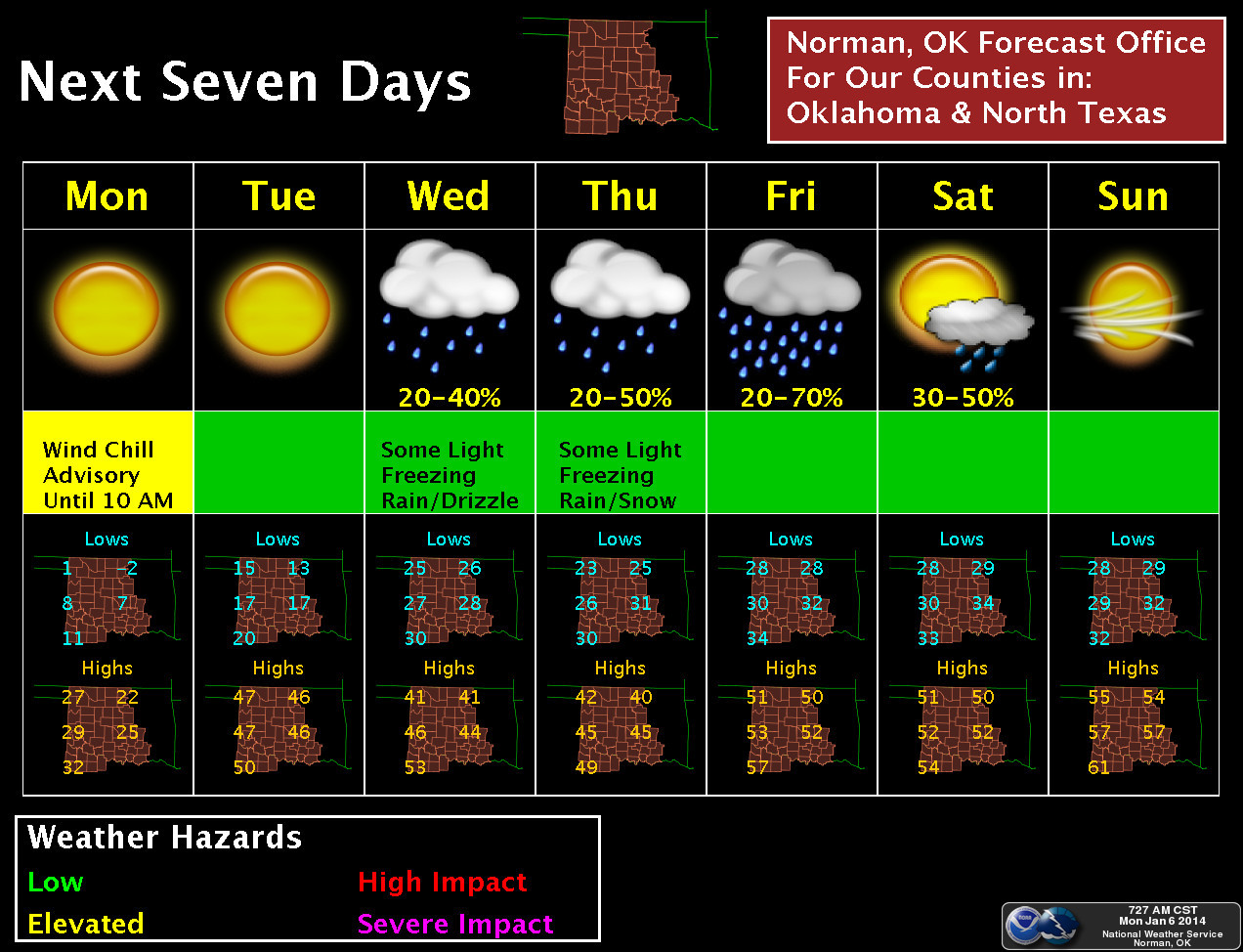
http://ticker.mesonet.org/archive/20140106/friday-forecast-highs.png
http://ticker.mesonet.org/archive/20140106/nws-norman-7day.jpg
We'll see how long it lasts. Hopefully until May.
Gary McManus
State Climatologist
Oklahoma Climatological Survey
(405) 325-2253
gmcmanus@mesonet.org
==================================================
The OCS/Mesonet Ticker
https://ticker.mesonet.org/
To subscribe or unsubscribe from the Ticker
or for questions about the Ticker or its content
Phone or Email the Ticker Manager at OCS
Phone: 405-325-2253 Email: ticker@mesonet.org
---------------------------------------------------
-C- Copyright 2024 Oklahoma Climatological Survey
===================================================
|


 Tweet
Tweet