MESONET TICKER ... MESONET TICKER ... MESONET TICKER ... MESONET TICKER ...
December 2, 2013 December 2, 2013 December 2, 2013 December 2, 2013
Winter Games
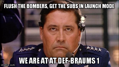
Get the Governor on the line. We may have to go through this thing all over again.
http://ticker.mesonet.org/archive/20131202/defbraums1.jpg
Yes, winter is on its way back, and we are declaring an official DEF-BRAUMS 1
level emergency!!
http://ticker.mesonet.org/archive/20131202/Braums-defcon-level.png
The irony (and it usually works this way) is that we're going to have some nice
warm weather for the next few days before the cold hits the fan. Those southerly
winds that get kicked up as a storm system approaches guarantees that, normally.
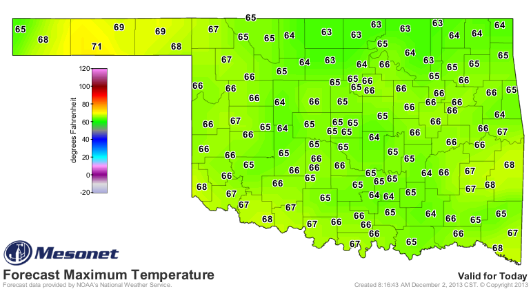
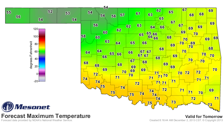
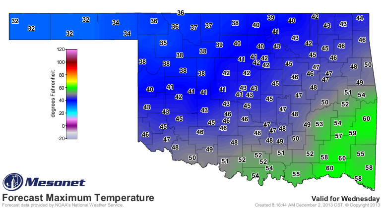
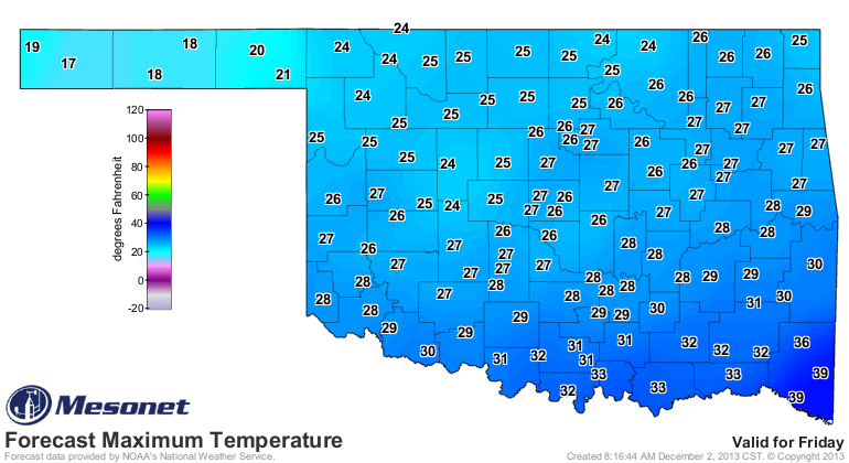
Check out the highs for Wednesday (at least as they are forecast now by the NWS).
Southern Oklahoma should approach record highs that afternoon.
http://ticker.mesonet.org/archive/20131202/monday-highs.png
http://ticker.mesonet.org/archive/20131202/tuesday-highs.png
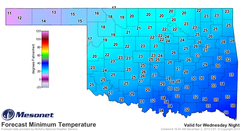
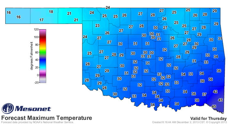
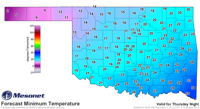
Then we have the front come through on Wednesday, and it goes downhill from
there. We will be going from possible record highs on Tuesday to possible record
lows (and record low maximums) by the weekend.
http://ticker.mesonet.org/archive/20131202/wed-highs.png
http://ticker.mesonet.org/archive/20131202/thursday-lows.png
http://ticker.mesonet.org/archive/20131202/thursday-highs.png
http://ticker.mesonet.org/archive/20131202/friday-lows.png
http://ticker.mesonet.org/archive/20131202/friday-highs.png
If you look at those low temperatures in the Panhandle on Friday morning, that
will give you a good idea of the strength of this cold front about to come
through. We may see our first sub-zero temperatures of the season.
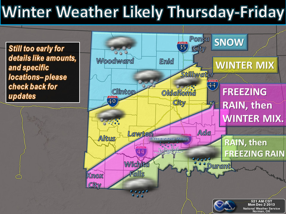
The real question, as usual, is what form of precipitation are we going to get,
if any? Well, it does appear we are in for another round of frozen precipitation
in the form of snow, sleet and freezing rain. As NWS-Norman cautions on this
map, it's still too early to determine amounts or types just yet, so stay
tuned.
http://ticker.mesonet.org/archive/20131202/nws-norman1.jpg
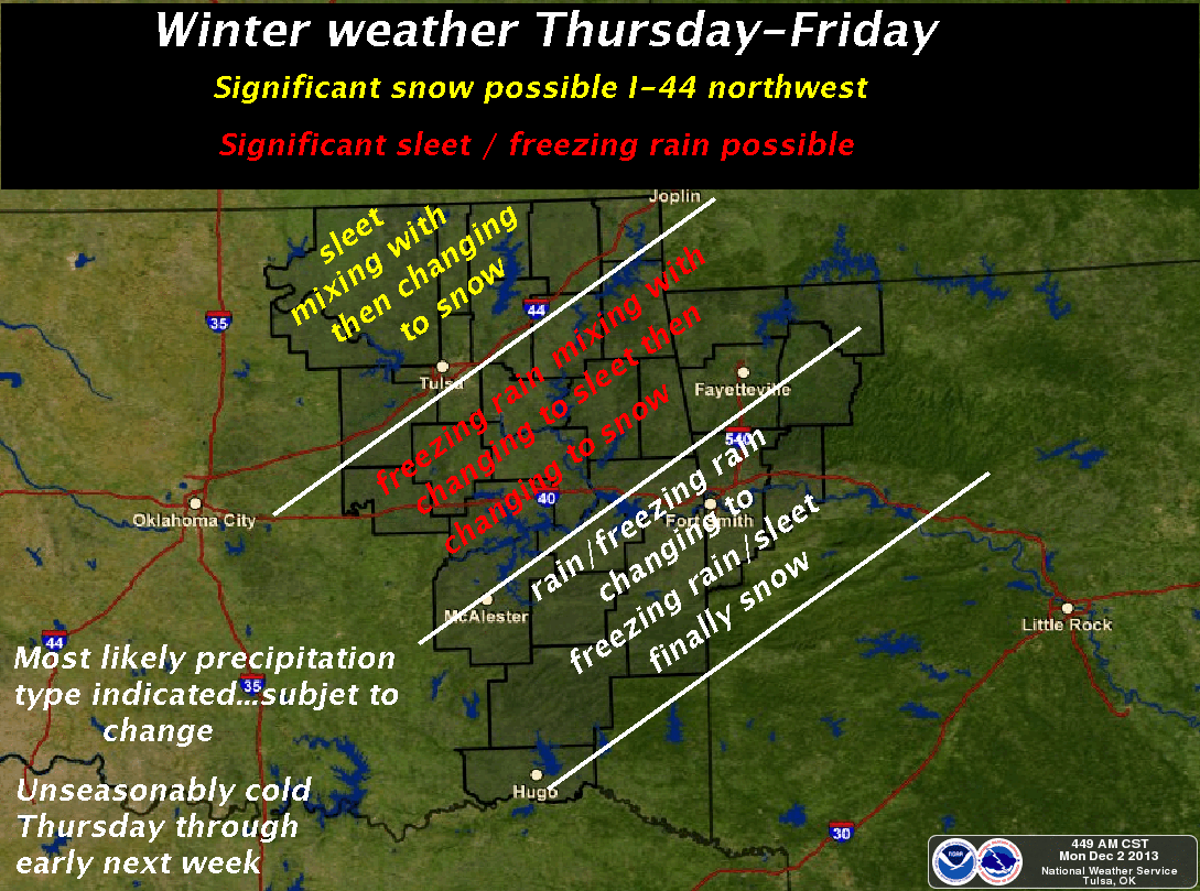
However, NWS-Tulsa has the word "significant" in their graphicast, so that's an
eye-popper this far out.
http://ticker.mesonet.org/archive/20131202/nws-tulsa.png
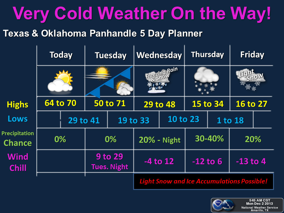
And let's not forget Amarillo's forecast for the Panhandle areas.
http://ticker.mesonet.org/archive/20131202/nws-amarillo.jpg
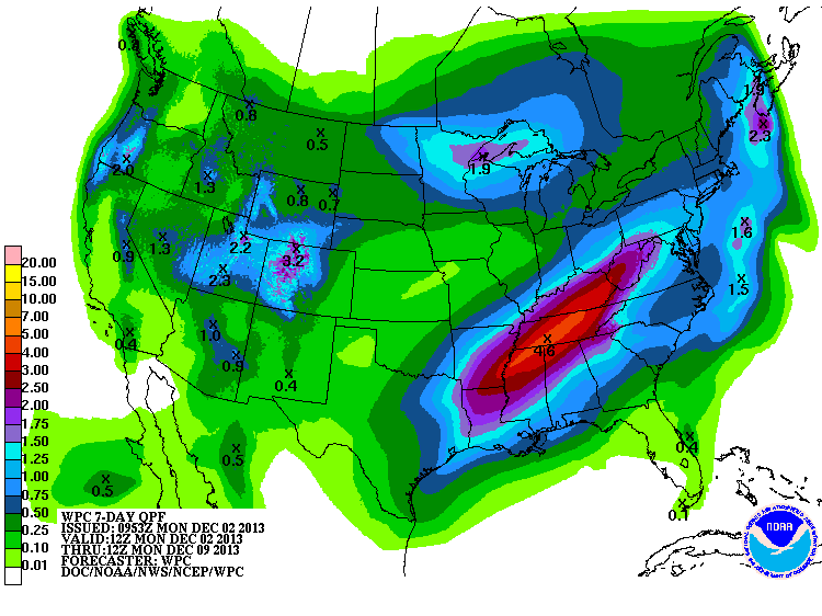
And it may not end there. There is another possible storm system lined up for
early next week as well. We can see the amount of moisture the cold air will
have to work with on this morning's 7-day rainfall forecast. This is for the
liquid equivalents of any frozen precipitation (e.g., 6 inches of snow might
translate into a half-inch of liquid rain when melted down).
http://ticker.mesonet.org/archive/20131202/7day-rain-forecast.gif
On top of all of that, we also have fire danger concerns for western Oklahoma
on Tuesday where a fire weather watch has been issued. Winds gusting to over 25
mph with relative humidity around 15 percent and the aforementioned near-record
highs in the 70s raise the concerns out in that area.
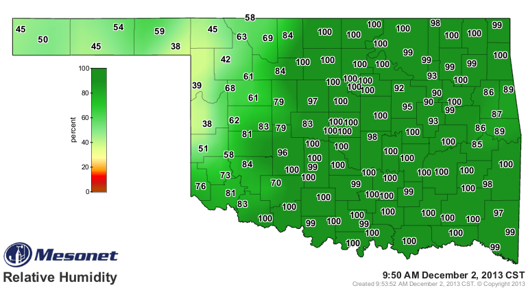
Heck, I'm not even sure you can read this thanks to the dense fog around this
morning! When the Mesonet's relative humidity maps start showing the 100s, you
know something's a bit dense out there (hey, I heard that!!).
http://ticker.mesonet.org/archive/20131202/current-RH-map.png
I'll leave you with some words from NWS Tulsa's forecast discussion from this
morning regarding the incoming inclement weather:
"ARCTIC AIR SPREADS SOUTHWARD THROUGH THE PLAINS AS THIS TROUGH
TAKES SHAPE. THIS WILL ALLOW WINTER TO RETURN TO THE AREA WITH A
VENGEANCE TUESDAY NIGHT/WEDNESDAY. WEDNESDAY WILL BE MUCH COOLER
MOST PLACES AND COMPARED TO THE REMAINDER OF THE WEEK AND
WEEKEND IT WILL FEEL BALMY. ONSET OF PRECIP TIMING STILL LOOKS TO
BE LATE WEDNESDAY NIGHT WITH PRECIP OVERSPREADING MUCH OF THE AREA
ON THURSDAY. IT WILL LIKELY CONTINUE THROUGH FRIDAY AND THEN TAPER
OFF AS STRONG LIFT OVER ARCTIC AIR WEAKENS ... SOME DECENT AMOUNTS
OF SNOW AND ICE ARE LIKELY THURSDAY THROUGH FRIDAY ... SURE THING IS
THAT WE WILL SEE A FAIRLY LENGTHY PERIOD OF BELOW FREEZING WEATHER
BEGINNING WEDNESDAY NIGHT WITH WINTRY PRECIP ALMOST A CERTAINTY
LATE THIS WEEK."
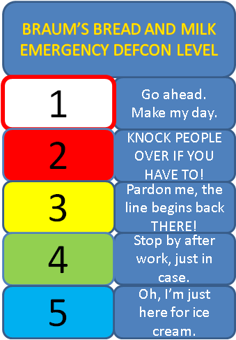
And that is we bumped up the BREAD AND MILK EMERGENCY levels to DEF-BRAUMS 1!
Remember, that level means "Go ahead ... make my day!" So when you're at Braum's
reaching for that last jug of milk, look at the other person reaching for it,
go all squinty-eyed and may the best Clint win.
Gary McManus
Associate State Climatologist
Oklahoma Climatological Survey
(405) 325-2253
gmcmanus@mesonet.org
==================================================
The OCS/Mesonet Ticker
https://ticker.mesonet.org/
To subscribe or unsubscribe from the Ticker
or for questions about the Ticker or its content
Phone or Email the Ticker Manager at OCS
Phone: 405-325-2253 Email: ticker@mesonet.org
---------------------------------------------------
-C- Copyright 2024 Oklahoma Climatological Survey
===================================================
|


 Tweet
Tweet