MESONET TICKER ... MESONET TICKER ... MESONET TICKER ... MESONET TICKER ...
December 3, 2013 December 3, 2013 December 3, 2013 December 3, 2013
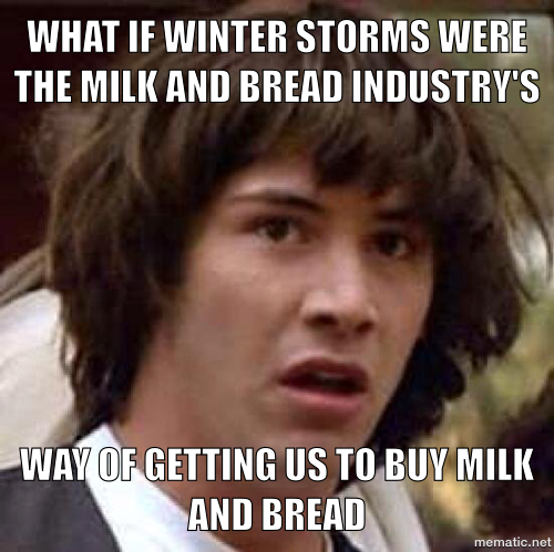
A conspiracy of ... whoa
http://ticker.mesonet.org/archive/20131203/Keanu_bread_milk.png
Mother Nature shows no signs of weakening as she prepares for her attack on our
fair state, and our decision to go to DEF-BRAUM'S LEVEL ONE still appears to be
a good one. Let's remember what the BREAD AND MILK EMERGENCY DEF-CON system is for
... it doesn't signify how MUCH snow or ice will occur, just that it will occur.
Why? Well, because it takes about a tenth of an inch of ice to cause Oklahoma to
shut down (I'm from here, I can say that ... you northerners that like to laugh,
try 100 days with temperatures above 100 degrees and see how you fare!).
The local NWS offices are fine-tuning their forecasts, and have now started to
react by issuing a winter storm watch for areas close to and south of the I-44
corridor.
http://ticker.mesonet.org/archive/20131203/latest.oklahoma.winter.gif
The wording of the watch gives a clue as to what the NWS Norman office is
thinking:
"THE NATIONAL WEATHER SERVICE IN NORMAN HAS ISSUED A WINTER STORM
WATCH...WHICH IS IN EFFECT FROM THURSDAY MORNING THROUGH FRIDAY
AFTERNOON. SIGNIFICANT AMOUNTS OF SNOW...SLEET...AND FREEZING RAIN ARE
EXPECTED OVER PARTS OF OKLAHOMA AND NORTH TEXAS. IN GENERAL...THE
MAIN SNOW AND SLEET IMPACTS ARE MOST LIKELY TO OCCUR NEAR...AND
NORTH OF...A LINE FROM LAWTON TO NORMAN TO SHAWNEE. FARTHER
SOUTH...ICE ACCUMULATION WILL BE THE MAIN CONCERN.
* TIMING: LIGHT FREEZING RAIN MAY BEGIN THURSDAY MORNING. HEAVIER
FREEZING RAIN...SLEET...AND SNOW ARE EXPECTED FROM THURSDAY
EVENING THROUGH FRIDAY MORNING.
* MAIN IMPACT: DANGEROUS DRIVING CONDITIONS WILL LIKELY RESULT
FROM ACCUMULATION OF ICE AND SNOW.
* OTHER IMPACTS: ICE ACCUMULATION MAY CAUSE POWER OUTAGES IN PARTS
OF SOUTHERN OKLAHOMA AND WESTERN NORTH TEXAS."
And from Tulsa:
"A MIX OF WINTRY WEATHER WILL ARRIVE IN EASTERN OKLAHOMA AND NORTHWEST
ARKANSAS THURSDAY MORNING. PLACES NEAR AND NORTHWEST OF INTERSTATE 44
WILL LIKELY EXPERIENCE A SLEET AND SNOW EVENT.
PLACES IN FAR SOUTHEAST OKLAHOMA AND WEST CENTRAL ARKANSAS WILL LIKELY
RECEIVE THE GREATEST AMOUNT OF FREEZING RAIN.
LOCATIONS IN EAST CENTRAL OKLAHOMA AND NORTHWEST ARKANSAS WILL SEE
FREEZING RAIN...SLEET...AND EVENTUALLY SOME SNOW. THERE COULD BE A
PROLONGED PERIOD OF SLEET AND FREEZING IN THAT AREA.
THE PRECIPITATION IS LIKELY TO COME IN TWO FAIRLY DISTINCT ROUNDS
WITH A FOUR TO EIGHT HOUR BREAK WITH JUST TRACE AMOUNTS.
* SIGNIFICANT SNOW AND SLEET OR ICE ACCUMULATION IS EXPECTED FROM THURSDAY
MORNING THROUGH FRIDAY AFTERNOON."
Sounds like a DEF-BRAUM'S LEVEL ONE to me (folks up north, you might be a level
3, however). The NWS Norman and Tulsa forecasters both mentioned the
POSSIBILITY of an ice storm down south, so keep that in mind. Braum's doesn't
sell generators, and I don't have a DEF-LOWE'S scale.
Here are the local NWS office graphics to give you a better picture (picture
... get it? Well, you will in a couple of days, smart aleck!)
http://ticker.mesonet.org/archive/20131203/nws-amarillo1.jpg
http://ticker.mesonet.org/archive/20131203/nws-amarillo2.jpg
http://ticker.mesonet.org/archive/20131203/nws-norman1.jpg
http://ticker.mesonet.org/archive/20131203/nws-norman2.jpg
http://ticker.mesonet.org/archive/20131203/nws-tulsa.gif
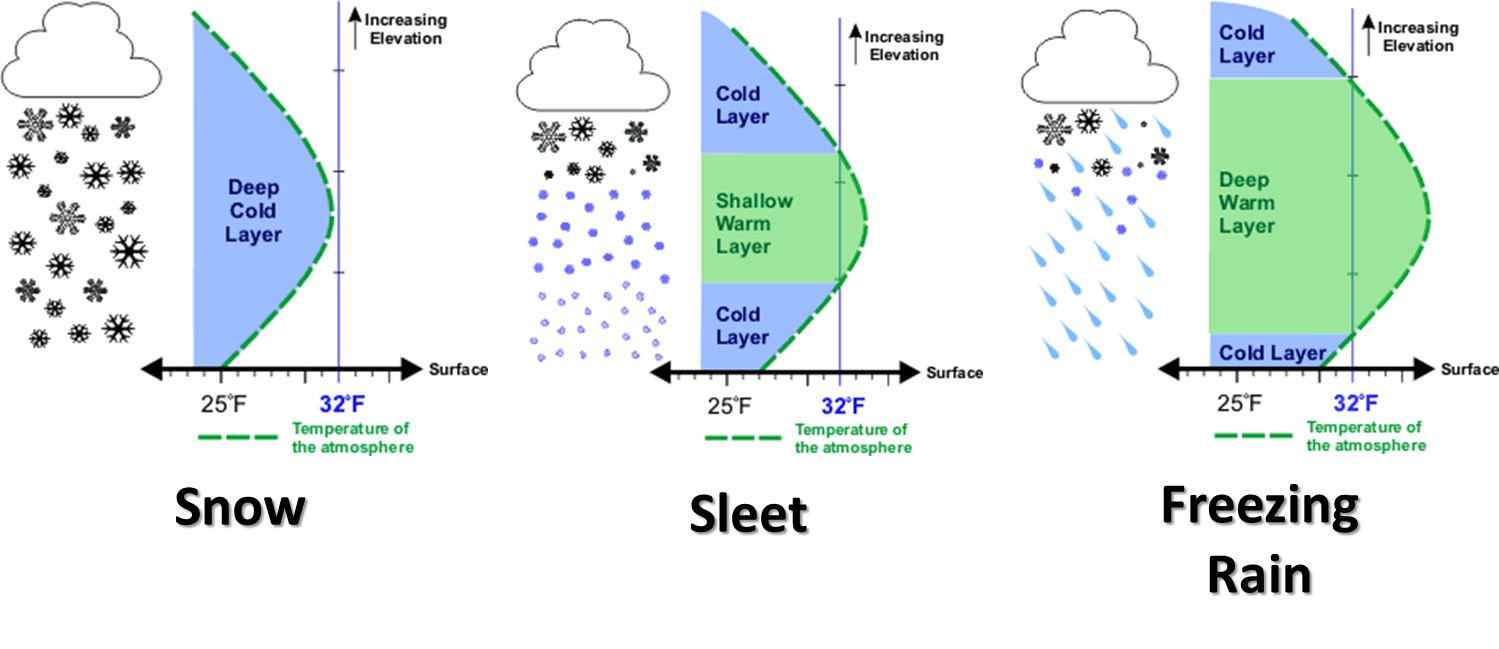
So what you get wherever you are located depends on how much moisture is
available, AND what your vertical air temperature profile looks like (the
atmosphere's ... not yours). Here's a look at the 7-day liquid equivalent
precipitation forecast for the next 7 days, and also a nice graphic from
NWS-Norman explaining how you get sleet, snow, freezing rain, or a mixture of
all of them. Remember when you see those half-inch amounts and above, that can
get pretty nasty when transformed into freezing precipitation types.
http://ticker.mesonet.org/archive/20131203/7day-rain.gif
http://ticker.mesonet.org/archive/20131125/winter-precip-types.png
Ready or not, here she comes!
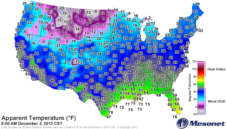
http://ticker.mesonet.org/archive/20131203/US.tair.png
http://ticker.mesonet.org/archive/20131203/US-windchill.png
Saturday morning lows
http://ticker.mesonet.org/archive/20131203/saturday-lows-forecast.png
Gary McManus
Associate State Climatologist
Oklahoma climatological Survey
(405) 325-2253
gmcmanus@mesonet.org
==================================================
The OCS/Mesonet Ticker
https://ticker.mesonet.org/
To subscribe or unsubscribe from the Ticker
or for questions about the Ticker or its content
Phone or Email the Ticker Manager at OCS
Phone: 405-325-2253 Email: ticker@mesonet.org
---------------------------------------------------
-C- Copyright 2024 Oklahoma Climatological Survey
===================================================
|


 Tweet
Tweet