MESONET TICKER ... MESONET TICKER ... MESONET TICKER ... MESONET TICKER ...
November 23, 2015 November 23, 2015 November 23, 2015 November 23, 2015
One soggy and/or frozen turkey sandwich, please
It's Thanksgiving Week (you're welcome for the reminder), so that means lots of
folks will be traveling here and yonder for Thanksgiving dinner, traveling even
faster away from said Thanksgiving dinner when they've had enough of Uncle Ed's
jokes, or even waiting in long lines for that Black Friday (Thursday night)
deal on 200-inch televisions. So obviously the weather forecast for this week
is important. We're still several days out, so the forecast is STILLLL a bit iffy
here and there on specific details, but there are a few things that appear to be
a sure bit (if still a bit fuzzy).
1. It's going to rain, and probably a lot, starting in some locations Wednesday
night, especially into Thanksgiving, and then over the next several days in coughs
and fits.
2. It's going to get cold thanks to a strong cold (duh!) front on Thanksgiving
night.
3. With the presence of the chance for precipitation (remember, the coughs and
fits and whatnot) and the presence of cold air, it appears there will be a
chance of some time of wintry precip over the weekend, in fact staring late
Thursday night up in the NW.
First, the moisture amounts associated with this system will be tremendous. The
atmosphere appears primed to go nuts on us. The Norman NWS forecast discussion
yesterday afternoon had this little gem to spring on us (I'm going to paraphrase
the forecaster here a bit to make it a bit more digestible:
"PRECIPITABLE WATER AMOUNTS (the amount of water vapor in the air
available to be turned into precip, basically) FROM THE GFS
(a forecast model) of around 1.7 INCHES! FOR THUR SUGGEST
AN INCREDIBLY MOIST ATMOSPHERE WILL BE IN PLACE. THIS AMOUNT WOULD
BE ~0.2 INCHES ABOVE THE HIGHEST EVER RECORDED DURING THE MONTH OF
NOV FROM AROUND 1950 TO PRESENT BASED ON SOUNDING CLIMATOLOGY FROM
SPC."
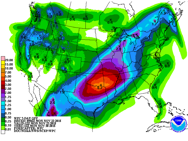
Well that's not good, unless you're taking a boat to Grandma's house. The 7-day
precip forecast is off the charts for this time of the year. Again, notice the
SE bias towards higher precip amounts.
http://ticker.mesonet.org/archive/20151123/7day-precip-forecast.gif
Holy cranberry sauce but that's a lot of water for November! The 3-4 inch amounts
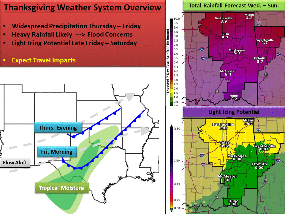
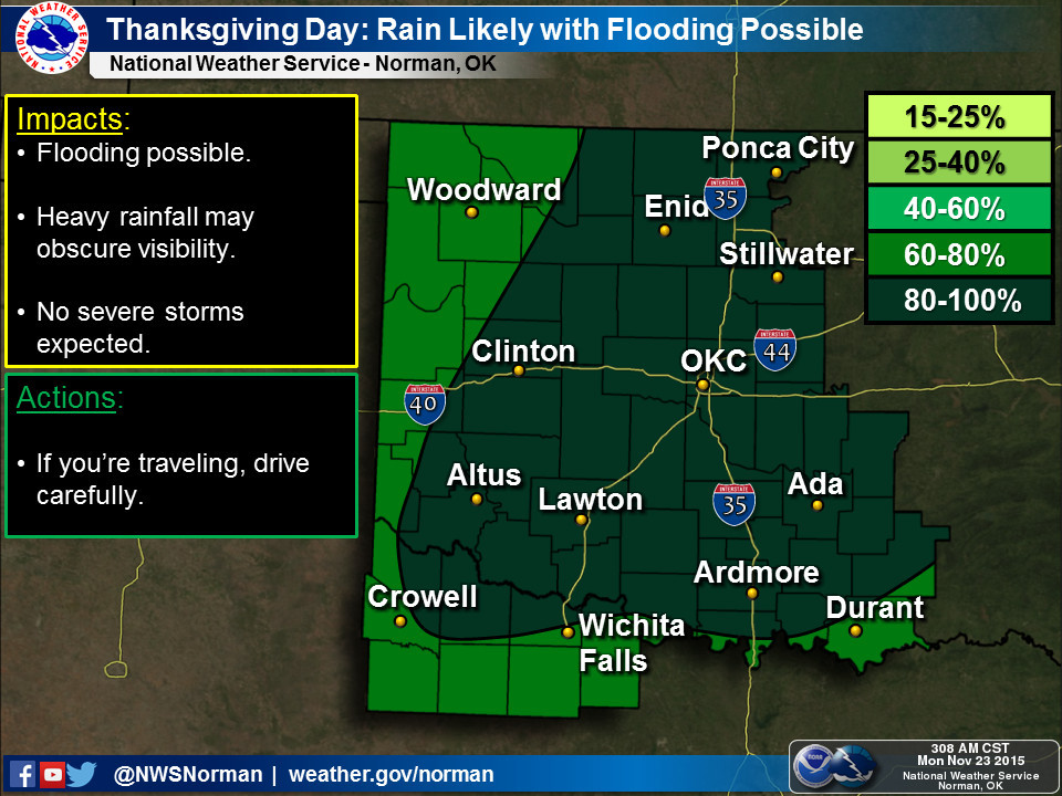
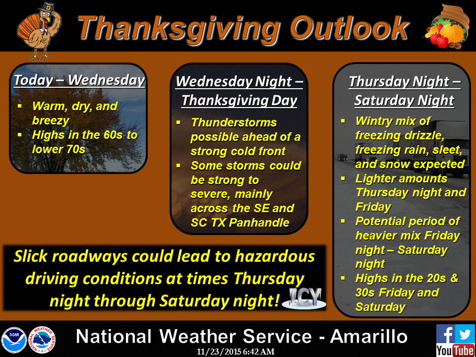
extend all the way up into NW OK. Here are a few graphics detailing what the
NWS offices that cover our state think of the holiday forecast, with complete
understanding and transparency that this can and probably will change to some
degree as we go through the week. In fact, it will probably change during the
event itself, so be sure to stay advised of the weather if you're traveling at
all.
http://ticker.mesonet.org/archive/20151123/nws-tulsa-thanksgiving.png
http://ticker.mesonet.org/archive/20151123/nws-norman-thanksgiving.jpg
http://ticker.mesonet.org/archive/20151123/nws-amarillo-thanksgiving.gif
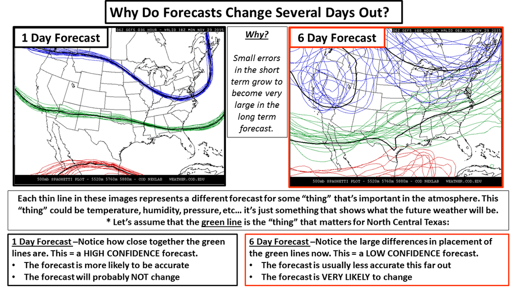
Notice the mention of flooding, then some slick travel concerns. The key here is
the location of the cold air coincident at the time of the precip, and right now
the forecast models just don't have a complete consensus right now. We showed
this on our Facebook page ( https://www.facebook.com/mesonet/ ) yesterday, but it's
worth showing again today. It comes from the NWS office in Ft. Worth, and it
shows the difficulty of making a forecast when the models don't show much
agreement.
http://ticker.mesonet.org/archive/20151123/forecasting-chaos.png
And the NWS Norman forecast discussion from this morning says the same thing,
but in words:
"...SITUATIONS LIKE THIS ARE VERY FLUID AND CONFIDENCE IS STILL NOT
HIGH THAT MODELS ARE HANDLING THE EVOLUTION OF THE UPPER LOW AND
LOW LEVEL THERMAL FIELDS WELL."
All that means that you need to stay tuned to the weather on a day-to-day and
even every few hour basis if you're going to be traveling, because it doesn't
take a lot of ice to cause a lot of problems. RIGHT NOW, it looks like we'll get
warm enough each day for things to stay liquid during the most important travel
times, but also it appears each night has the capability to get cold enough
to cause some of that icing. Again, I turn to the Norman NWS office for some
elucidation.
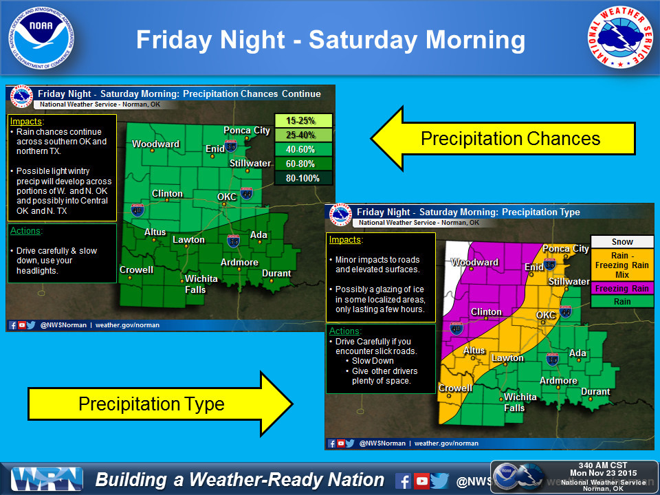
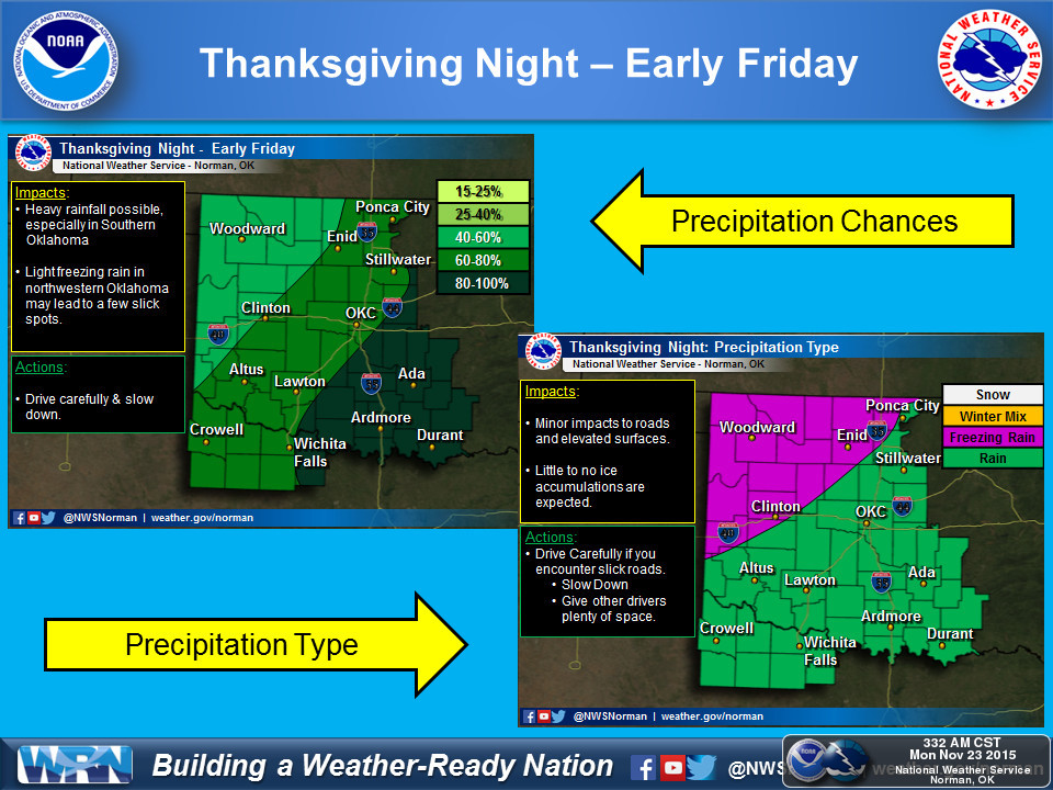
http://ticker.mesonet.org/archive/20151123/nws-norman-fri-day-transition.jpg
http://ticker.mesonet.org/archive/20151123/nws-norman-thurs-fri-transition.jpg
RIGHT NOT this doesn't look like a serious winter event for most of the state,
but it could be a bit more serious across the NW. And again, that could expand
to the SE depending on the temperature profiles of the atmosphere. Remember
points 1-3 above which are pretty high on the confidence level right now...it's
going to rain (a lot), it's going to get cold, and there will be some frozen
precip that could impact travel somewhere in the state late Thursday into the
weekend.
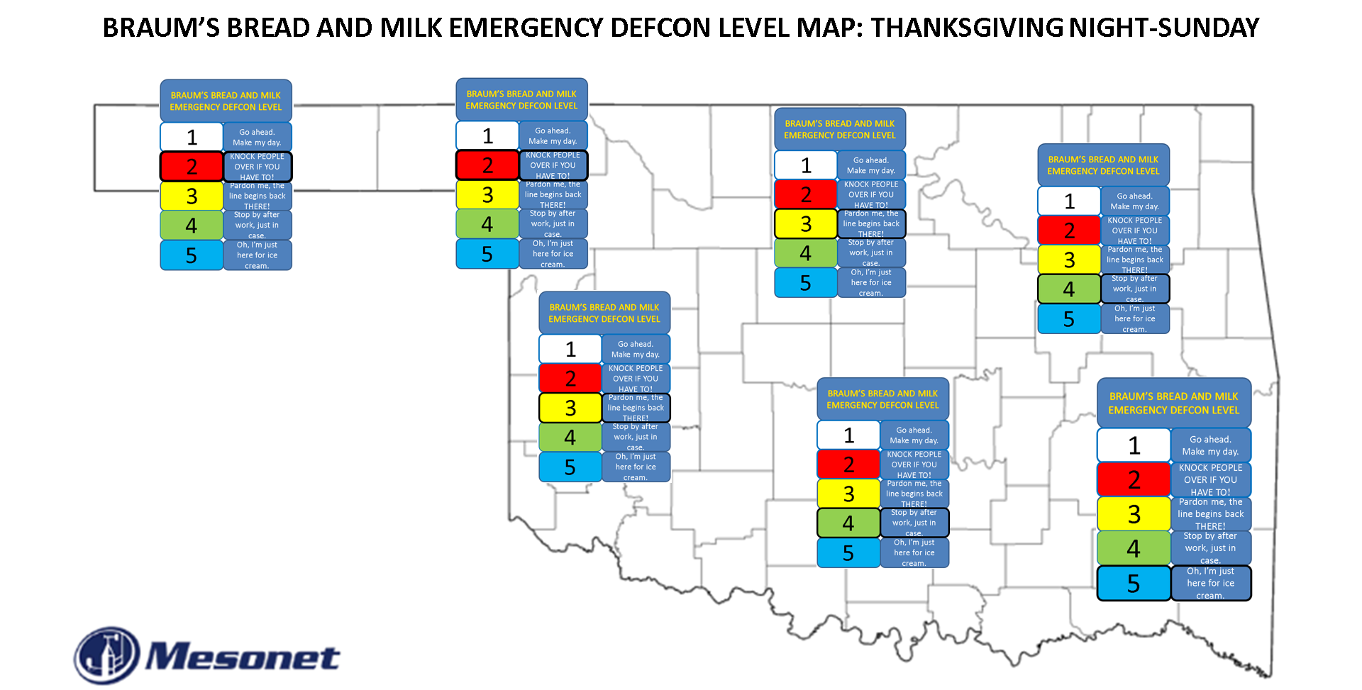
In light of that, here is a preliminary BRAUM'S EMERGENCY BREAD AND MILK DEF-CON
map for the state for Thursday night into Saturday. Very preliminary, very
much geared to daytime travel risks. If you're out at 3am making a run to
Braum's, you're not only in for some possibly risky travel conditions, but a
long wait until Braum's opens!
http://ticker.mesonet.org/archive/20151123/DEF-BRAUMS-MAP.png
Will we update this DEF-BRAUMS Map? Ask the atmosphere. If you get an answer,
let us know!
Gary McManus
State Climatologist
Oklahoma Mesonet
Oklahoma Climatological Survey
(405) 325-2253
gmcmanus@mesonet.org
==================================================
The OCS/Mesonet Ticker
https://ticker.mesonet.org/
To subscribe or unsubscribe from the Ticker
or for questions about the Ticker or its content
Phone or Email the Ticker Manager at OCS
Phone: 405-325-2253 Email: ticker@mesonet.org
---------------------------------------------------
-C- Copyright 2024 Oklahoma Climatological Survey
===================================================
|


 Tweet
Tweet