MESONET TICKER ... MESONET TICKER ... MESONET TICKER ... MESONET TICKER ...
October 18, 2012 October 18, 2012 October 18, 2012 October 18, 2012
Drought
Strap in...there's a lot of info in this one, and not all of it pretty. For
those that can't wait for the end, here's the final synopsis based on the current
drought picture and climate outlooks: look for a significant portion of Oklahoma
to be in some degree of drought intensity as we emerge from winter into spring
next year.
--------------------------------------------------------------------------------
The Current Drought Picture
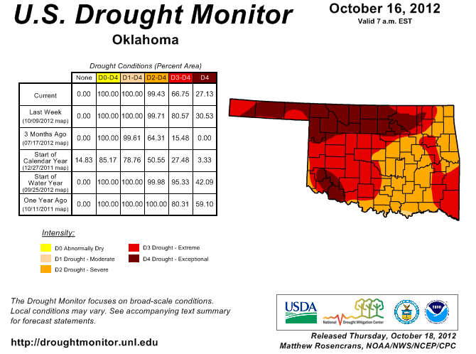
Okay, having your state's severe-exceptional drought drop from 99.71% to 99.43% on
this morning's U.S. Drought Monitor release may not seem like much of an
improvement, but it's what was precipitated (pun foretelling!) the drop that's
important. The amount of extreme-exceptional drought DID see a substantial drop,
from 81% to 67%. And the amount of exceptional drought dropped from 31% to 27%.
http://ticker.mesonet.org/archive/20121018/ok_dm.png
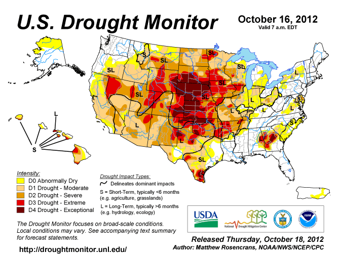
Much of the Great Plains westward is still painted in severe-exceptional drought
just in time for the climatological drop in precipitation, unfortunately.
http://ticker.mesonet.org/archive/20121018/drmon.gif
We owe the improvements to a couple of nice rainfall events over the last 30 days
or so.
http://ticker.mesonet.org/archive/20121018/30day-rainfall.png
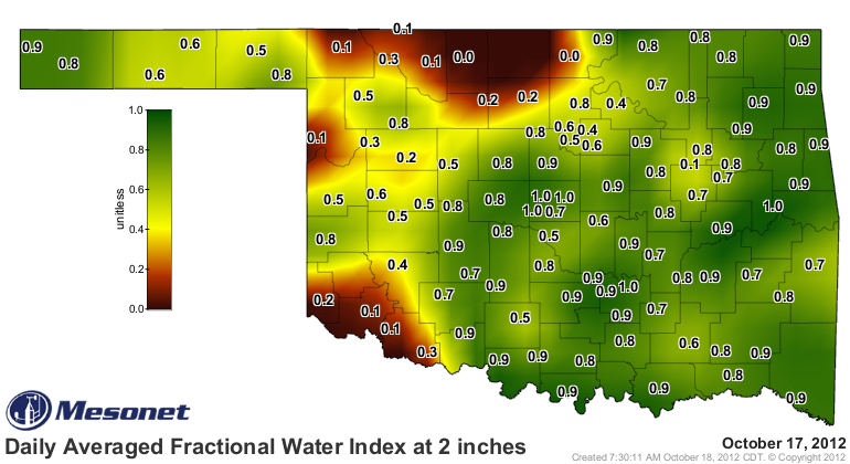
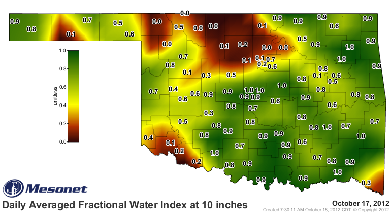
That moisture has improved our soil moisture situation, at least in the upper
soils. The Mesonet's soil moisture maps are now painted a nice shade of green at
the 2- and 10-inch levels.
http://ticker.mesonet.org/archive/20121018/2inch-soilmoisture.png
http://ticker.mesonet.org/archive/20121018/10inch-soilmoisture.png
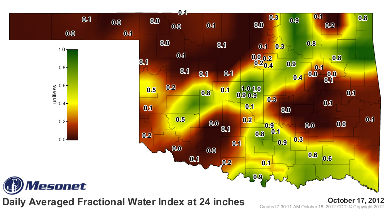
Things are not quite so rosy at 24 inches, but it's still an improvement over
the all-brown map we saw last month.
http://ticker.mesonet.org/archive/20121018/24inch-soilmoisture.png
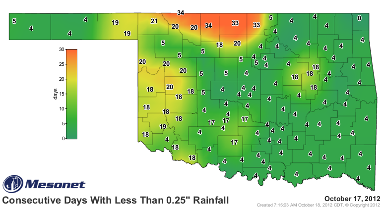
The big problem area remains in northern Oklahoma, parts of which have now gone
more than a month without at least a quarter inch of rain in a single day.
http://ticker.mesonet.org/archive/20121018/mesonet.rainfall.quarterinch.png
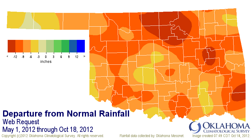
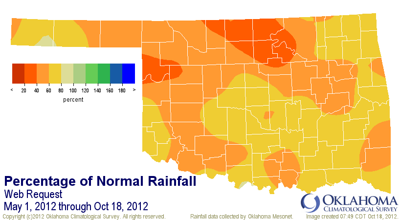
The reason we still have 99% of the state covered by severe-exceptional drought
becomes obvious when looking at our rainfall deficits since May 1. Statewide,
the deficit for that period is still running at 8.9 inches, and ranks as the
3rd driest such span since 1921. For north central Oklahoma, it is THE driest
since 1921. The Mesonet rainfall maps show much of north central Oklahoma
running more than 12 inches below normal and less than 6 inches of actual
rainfall since May 1.
http://ticker.mesonet.org/archive/20121018/may1-oct18-tots.png
http://ticker.mesonet.org/archive/20121018/may1-oct18-dep.png
http://ticker.mesonet.org/archive/20121018/may1-oct18-pct.png
-------------------------------------------------------------------------------
Outlooks
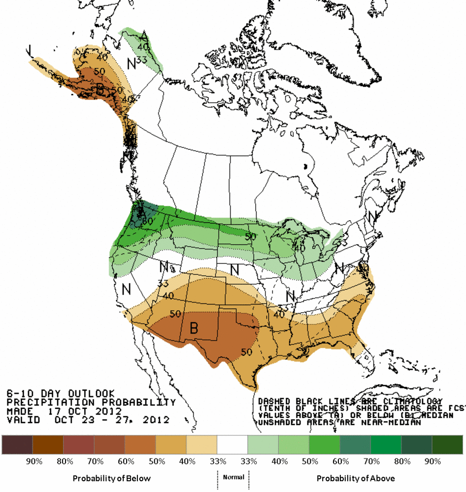
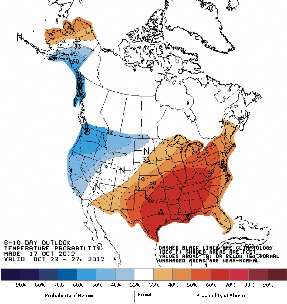
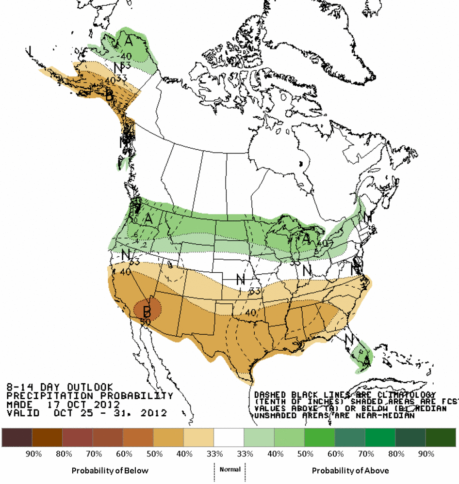
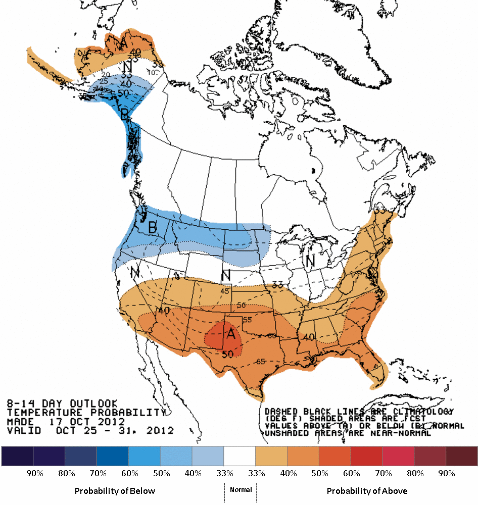
Okay, let's look ahead and see what the Climate Prediction Center is seeing
in our future.
Warmer and drier than normal for the rest of October:
http://ticker.mesonet.org/archive/20121018/610prcp.new.gif
http://ticker.mesonet.org/archive/20121018/610temp.new.gif
http://ticker.mesonet.org/archive/20121018/814prcp.new.gif
http://ticker.mesonet.org/archive/20121018/814temp.new.gif
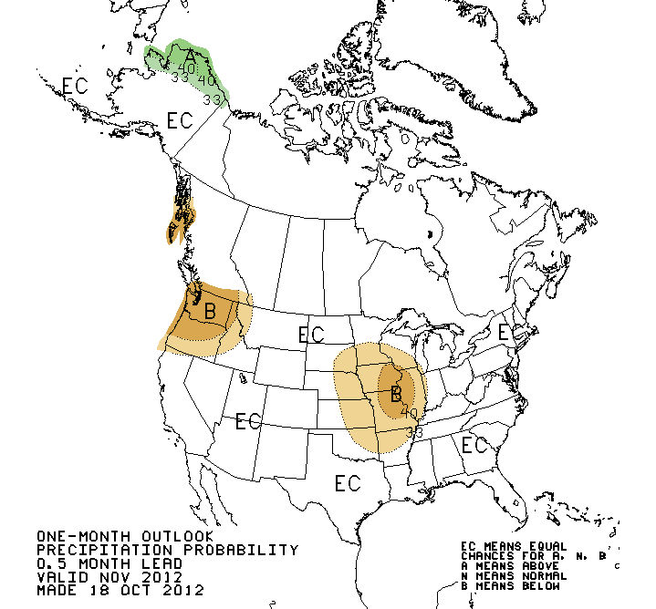
A warmer than normal November, and possibly drier than normal in the northeast
sections of the state (the rest of the state, equal chances of above-, below-,
or near-normal):
http://ticker.mesonet.org/archive/20121018/nov-precip.gif
http://ticker.mesonet.org/archive/20121018/nov-temps.gif
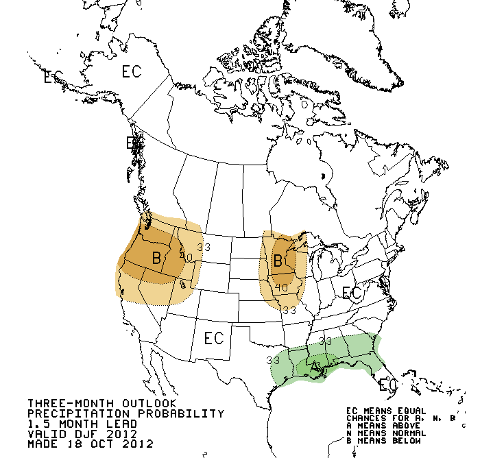
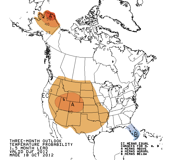
A warmer than normal winter period, and equal chances for precipitation (DOES
NOT MEAN GREATER CHANCES OF "NORMAL"!!!):
http://ticker.mesonet.org/archive/20121018/dec-feb-precip.gif
http://ticker.mesonet.org/archive/20121018/dec-feb-temps.gif
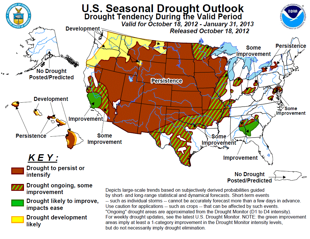
All of that together spells a Seasonal Drought Outlook from the CPC that looks
for drought persistence or intensification for the northern half of the state
and the possibility of "some improvement" in the southern half of the state
(although drought still ongoing), though February.
http://ticker.mesonet.org/archive/20121018/season_drought.gif
Normally this is where I give you their reasoning, but I'll sum it up in a
nutshell: the El Nino we were hoping might bring us some relief has fizzled and
ENSO-Neutral conditions (or a very weak El Nino) now look more likely, PLUS we
are about to enter the driest part of the year climatologically as we
transition from our secondary wet season into winter.
The uncertainty of the ENSO outlook does lead the CPC forecasters to place
low confidence in the outlooks, but I'll just come right out and say it ...
even if El Nino does develop, it will be weak which doesn't help Oklahoma
at all. We will need some other climate factor, known or otherwise, to help us
this winter.
A nice split flow jet stream like last winter that spoiled La Nina's expected
dry climate regime would be nice. Are you hearing me, Mother Nature?
Gary McManus
Associate State Climatologist
Oklahoma Climatological Survey
(405) 325-2253
gmcmanus@mesonet.org
==================================================
The OCS/Mesonet Ticker
https://ticker.mesonet.org/
To subscribe or unsubscribe from the Ticker
or for questions about the Ticker or its content
Phone or Email the Ticker Manager at OCS
Phone: 405-325-2253 Email: ticker@mesonet.org
---------------------------------------------------
-C- Copyright 2024 Oklahoma Climatological Survey
===================================================
|


 Tweet
Tweet