MESONET TICKER ... MESONET TICKER ... MESONET TICKER ... MESONET TICKER ...
September 16, 2014 September 16, 2014 September 16, 2014 September 16, 2014
Odile...OH DILLLLLLLLE!
I have not a clue what that title meant. I think I was going for a Harry Belafonte
thing (for the youngsters, think Pharrell 40 years ago, but without the hat). But
as you have probably heard, the remnants of Hurricane Odile appear to be headed
for the area this weekend. In addition to that, a strong cold front will come
barreling through the Plains Saturday. I don't think this is a classical 5+ inches
of rain event like we've sometimes seen in the past. For one thing, that front
will not go stationary in that it looks fairly strong and will probably move
through with some gusto. For those real toad-strangling rains, we'd need to see
that front stall out and then the remnants of Odile could interact with that
feature. Regardless, as of now, the combination of the two features is starting
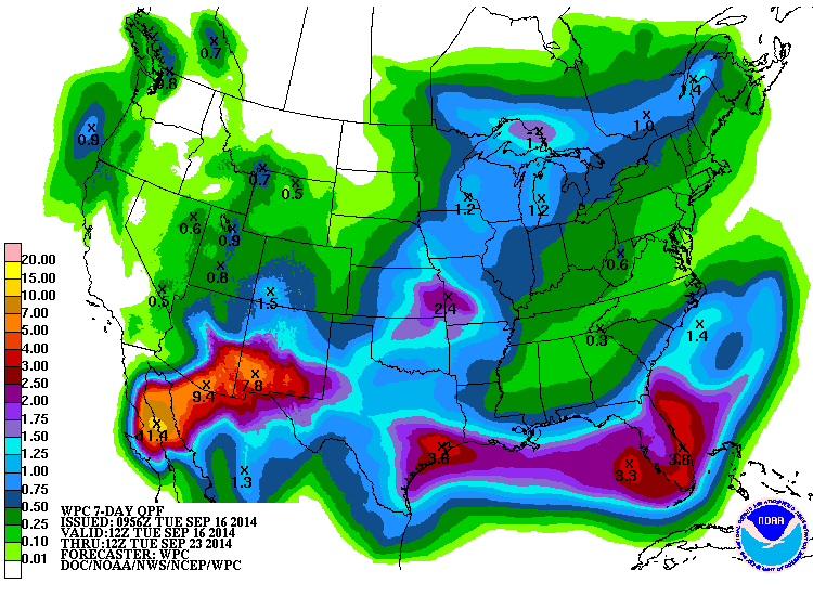
to paint the state green (and blue) and the rainfall forecast maps.
http://ticker.mesonet.org/archive/20140916/7day-rain-forecast.gif
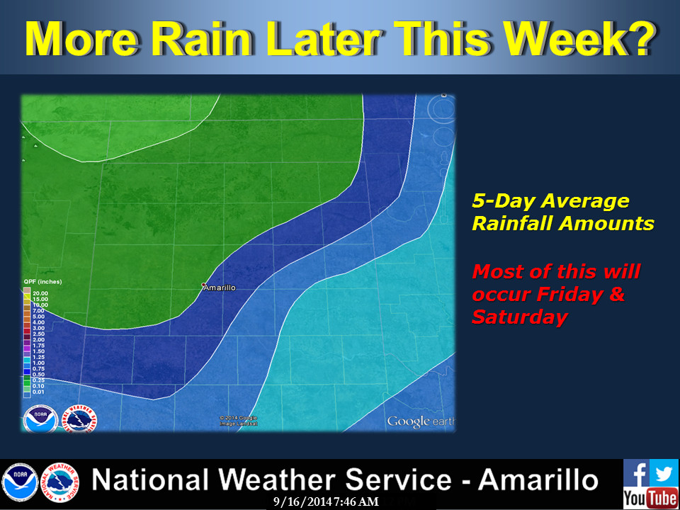
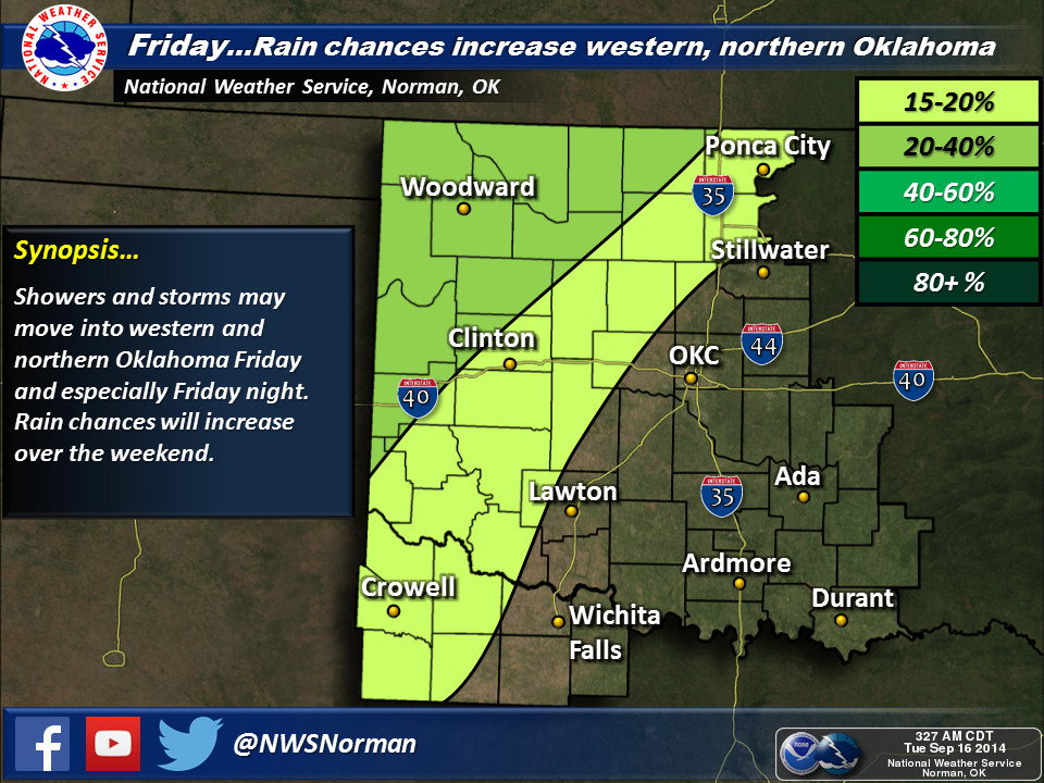
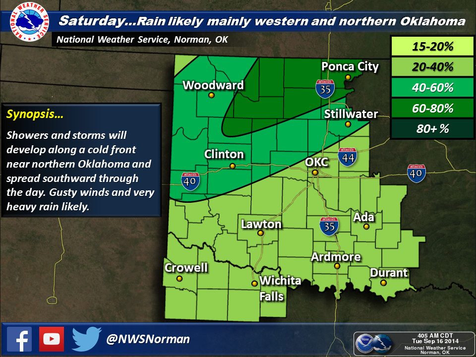
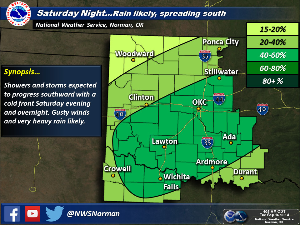
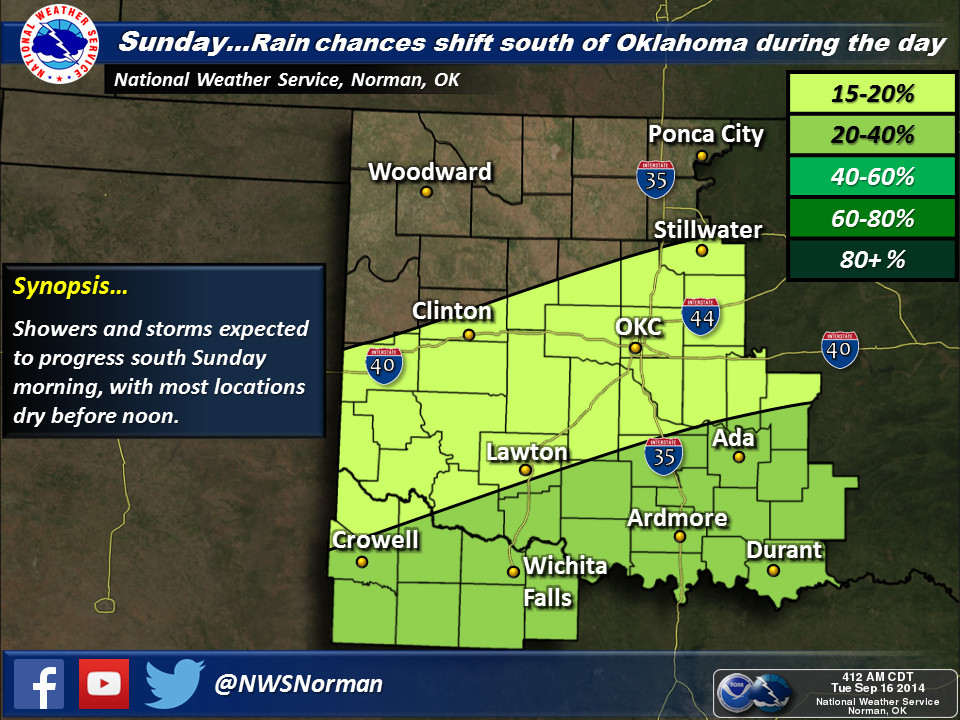
Here are the takes from the local NWS offices for this weekend.
http://ticker.mesonet.org/archive/20140916/nws-amarillo.jpg
http://ticker.mesonet.org/archive/20140916/nws-norman1.jpg
http://ticker.mesonet.org/archive/20140916/nws-norman2.jpg
http://ticker.mesonet.org/archive/20140916/nws-norman3.jpg
http://ticker.mesonet.org/archive/20140916/nws-norman4.jpg
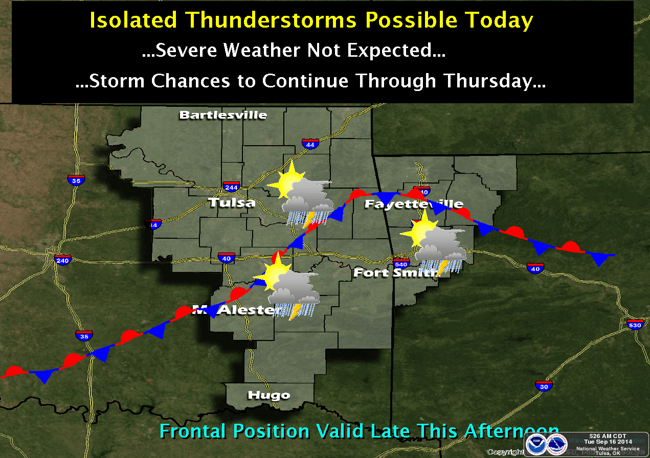
And Tulsa reminds us that there is a chance of rain for the next few days as
well (although the amounts should be fairly modest) as another front hangs
about the area.
http://ticker.mesonet.org/archive/20140916/nws-tulsa.png
Now let's get back to that history of pacific tropical system remnants and
stalled frontal zones. We've detailed this before in the Ticker, so here's a
bit more about it. Again, I don't think this is going to end up being one of
those classic cases, like below. But it definitely reminds us of the potential
for drought-ending events when these sort of things time up correctly.
------------------------------------------------------------------------------
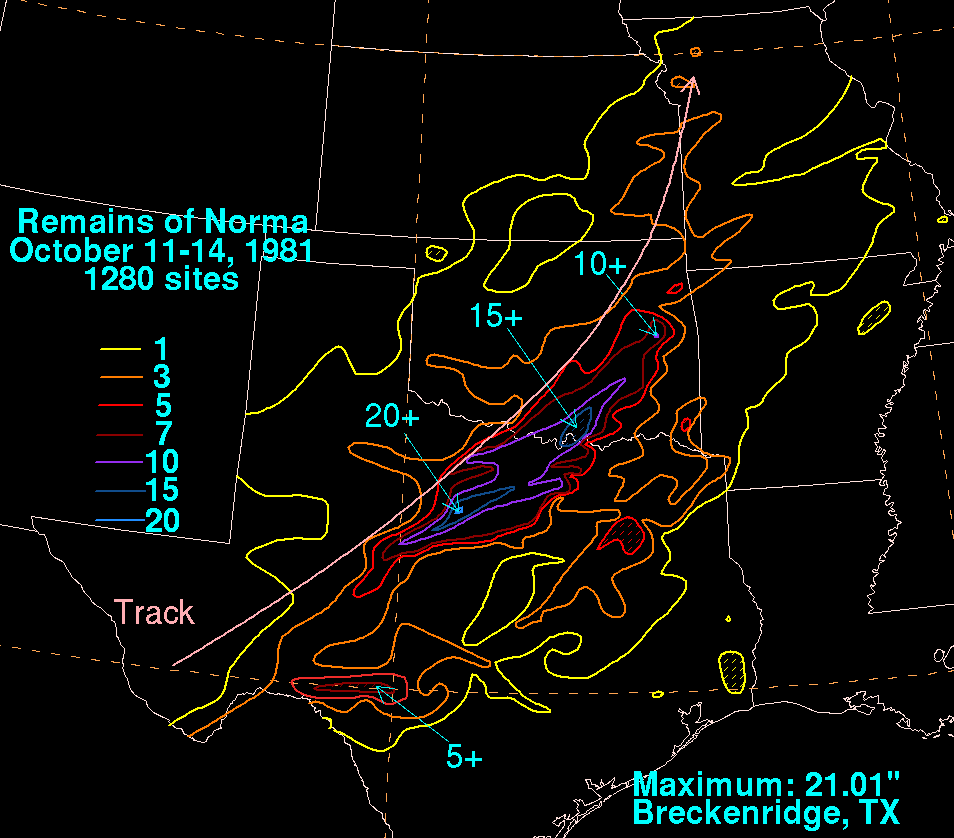
Some of our most extreme rainfall events on record have occurred when pacific
hurricane remnants and stalled frontal boundaries mingled over the state. Here
are the greatest 1-day through 7-day rainfall totals on record in the state.
Enid's massive one-day total remains the state's greatest 1-day rainfall total
in history, but the 2-day through 7-day totals all belong to pacific hurricane
Norma and the front she hung out with back in October 1981.
http://ticker.mesonet.org/archive/20120924/norma-rainfall-1981.png
-****-
Duration Ppt Total Ending Date Location
1-day 15.68" Oct 11, 1973 Enid
2-day 18.02" Oct 14, 1981 Tishomingo
3-day 18.68" Oct 14, 1981 Kingston
4-day 22.47" Oct 16, 1981 Tishomingo
5-day 23.12" Oct 17, 1981 Tishomingo
6-day 23.95" Oct 18, 1981 Coalgate
7-day 24.95" Oct 18, 1981 Coalgate
-***-
Here's a brief synopsis on previous encounters between pacific hurricane
remnants and Oklahoma, compiled by former Associate State Climatologist and the
original entire Ticker staff, Deke Arndt. We'll start with the Grandmomma of
them all (at least in modern Oklahoma history), Hurricane Norma.
----------------------------------------------------------------------------------
Pacific Hurricane Norma, October 1981.
Norma formed off the Mexican coast on the 9th, and quickly became a Category 3
hurricane before weakening slightly and making landfall near Mazatlan. Her
remnants made their way into the southern plains by the 11th and encountered a
stationary front draped across north Texas. Norma?s rains in south-central,
southeast and eastern Oklahoma were both torrential and long-lasting. A swath
stretching from around the Lake Texoma region to Eufaula saw more than a foot of
rain, with local values exceeding 15 inches. The greatest two-day, three-day,
four-day, five-day, six-day and seven-day rainfall totals ever recorded in
Oklahoma are all related to Norma. Two drowned in the state, with at least $50
million in property damage. The system also spawned two F1 tornadoes in southern
Oklahoma, causing two injuries.
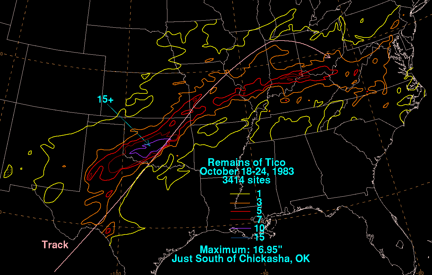
Pacific Hurricane Tico, October 1983.
Most of Oklahoma was already waterlogged by a very wet autumn when Tico?s remnants
met a stalled >front in Oklahoma in mid-month. More than a foot of rainfall
drenched the I-44 corridor. Widespread flooding occurred throughout the state,
notably on the irritable Cottonwood Creek in Guthrie, where a man was swept to his
death. A train was derailed in Altus when the tracks were washed away underneath
it. In subsequent days, several locations on the Red and Washita Rivers recorded
all-time high streamflows.
http://ticker.mesonet.org/archive/20120924/tico-rainfall-1983.png
Pacific Hurricane Waldo, October 1985.
Far western Oklahoma is not immune to large rainfall totals from Pacific storms.
Waldo left a wide swath of rain across the northwestern half of Oklahoma, and the
Buffalo area saw more than five inches.
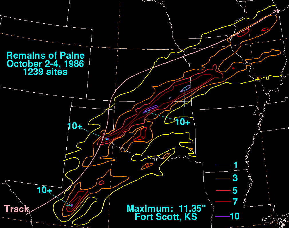
Pacific Hurricane Paine, October 1986.
Accumulations in excess of fifteen inches were commonplace in the opening days of
October 1986. The Oklahoma epicenter of Paine?s downpour lay in the north-central
parts of the state, where upwards of ten inches fell in the Perry area and in Kay
County. The Cimarron River saw its flood of record at several gages in central
Oklahoma, and Tulsa flood damages approached $35 million. Agricultural damages,
particularly in the winter wheat belt, were tremendous.
http://ticker.mesonet.org/archive/20120924/paine-rainfall-1986.png
Pacific Hurricane Raymond, October 1989.
Interestingly, Raymond was a cousin of catastrophic Hurricane Hugo that battered
the Carolinas in 1989. He was spawned in the Pacific by the same traveling
tropical wave that ignited Hugo three weeks earlier in the Atlantic. Raymond?s
rainfall footprint resembled that left by Paine in 1989, but peak accumulations
were less than four inches.
Pacific Hurricane Lester, August 1992.
A major swath of Oklahoma?s wheat belt was the beneficiary of one-to-three-inch
rains related to Lester in late August. Lester also caused major flooding in the
American southwest, as well as minor flooding days later in the Midwest. Very
little of Lester?s impact made the news, because at the same time, Atlantic
Hurricane Andrew was becoming the costliest natural disaster of the 20th Century.
Pacific Hurricane Ismael, September 1995.
After dumping more than half a foot of rain in eastern New Mexico and west Texas,
Ismael left few scars on Oklahoma. However, it did provide nearly three inches of
rainfall to much of the Arbuckles region.
Gary McManus
State Climatologist
Oklahoma Mesonet
Oklahoma Climatological Survey
(405) 325-2253
gmcmanus@mesonet.org
==================================================
The OCS/Mesonet Ticker
https://ticker.mesonet.org/
To subscribe or unsubscribe from the Ticker
or for questions about the Ticker or its content
Phone or Email the Ticker Manager at OCS
Phone: 405-325-2253 Email: ticker@mesonet.org
---------------------------------------------------
-C- Copyright 2024 Oklahoma Climatological Survey
===================================================
|


 Tweet
Tweet