MESONET TICKER ... MESONET TICKER ... MESONET TICKER ... MESONET TICKER ...
February 10, 2017 February 10, 2017 February 10, 2017 February 10, 2017
Soooooo hot!
http://ticker.mesonet.org/archive/20170210/record-deluxe.jpg
It's not supposed to be this way, but it has been before. Back on January 31 and
February 1, 1911, highs rose into the 80s and 90s across the state, with the NWS
cooperative observing stations at Cloud Chief and Guthrie reaching 93 degrees on
Feb. 1. That is the highest temperature ever recorded that early in the year in
Oklahoma history. In other words, the highest temperature ever recorded in the
state from Jan. 1-Feb. 10, dating back to the 1880s. Well why didn't I say that
before? Don't know. Some people good with words...others gooder. Anyway, while
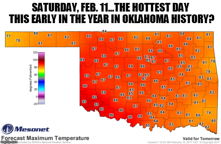
today will be hot across western Oklahoma (warm elsewhere), Saturday is going to
be HOT across nearly the entire state.
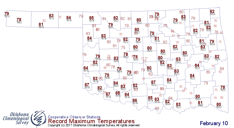
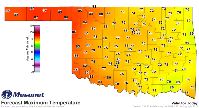
Here are the record highs for today vs. what's expected.
http://ticker.mesonet.org/archive/20170210/feb10-record-highs.png
http://ticker.mesonet.org/archive/20170210/todays-forecast-highs.png
The highest temperature ever recorded on Feb. 10 was 87 degrees at Frederick,
Hollis and Pauls Valley back in 1976 for the first two and 1922 for the third.
I bet we beat that today. I'll say...Hooker or Goodwell. They've had an uncanny
string of statewide high temps throughout the last 6 months...mostly due to
drought I think.
But tomorrow. Tomorrow, aye, there's the rub. If 93 degrees is the previous
highest-this-early, I think that will be eclipsed also. Altus? Hollis, maybe?
Always a mistake to count out Grandfield. Somebody will do it.
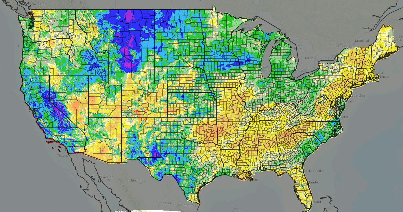
All this heat and wind sends ill tidings to the state, which is now the epicenter
of drought in the U.S. Check out this 180-day pct of normal precip map for the
U.S. You don't need to see the scale...you know the drill. Red and orange colors
are bad. Sorry bedlam fans, it's true.
http://ticker.mesonet.org/archive/20170210/180day-pct-normal-precip.png
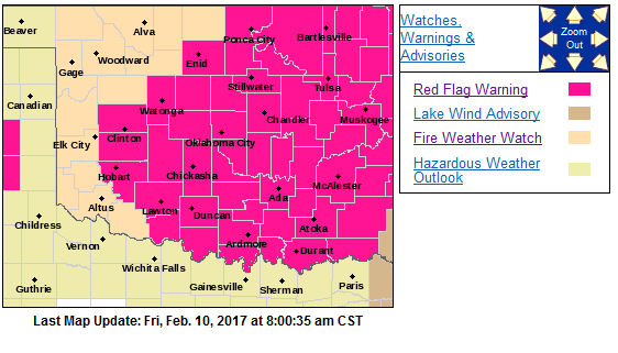
Anyway, fire danger kicks off today and continues tomorrow. There's already
a Red Flag Fire warning for much of Oklahoma, and a fire weather watch for
tomorrow.
http://ticker.mesonet.org/archive/20170210/fire-advisories.png
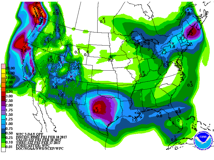
Rain chances are increasing with the approach of that upper-level low. Maybe
some snow that sizzles as it hits the sidewalk here and there...no accumulations
expected. The moisture is needed, but it ain't going to be a drought-quencher,
especially north of I40.
http://ticker.mesonet.org/archive/20170210/7day-precip-forecast.gif
So another month, another storm. As I've said before, one storm a month ain't
gonna cut it. Here's hoping for later next week.
Gary McManus
State Climatologist
Oklahoma Mesonet
Oklahoma Climatological Survey
(405) 325-2253
gmcmanus@mesonet.org
==================================================
The OCS/Mesonet Ticker
https://ticker.mesonet.org/
To subscribe or unsubscribe from the Ticker
or for questions about the Ticker or its content
Phone or Email the Ticker Manager at OCS
Phone: 405-325-2253 Email: ticker@mesonet.org
---------------------------------------------------
-C- Copyright 2024 Oklahoma Climatological Survey
===================================================
|


 Tweet
Tweet