MESONET TICKER ... MESONET TICKER ... MESONET TICKER ... MESONET TICKER ...
January 4, 2015 January 4, 2015 January 4, 2015 January 4, 2015
Winter Finally Finds December
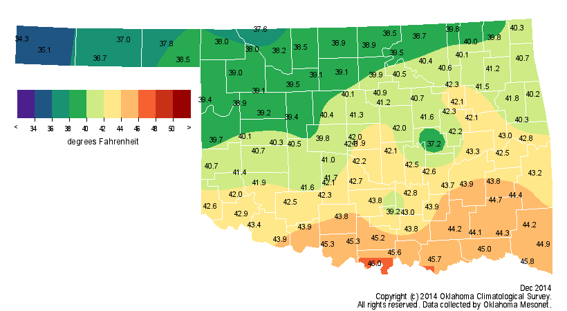
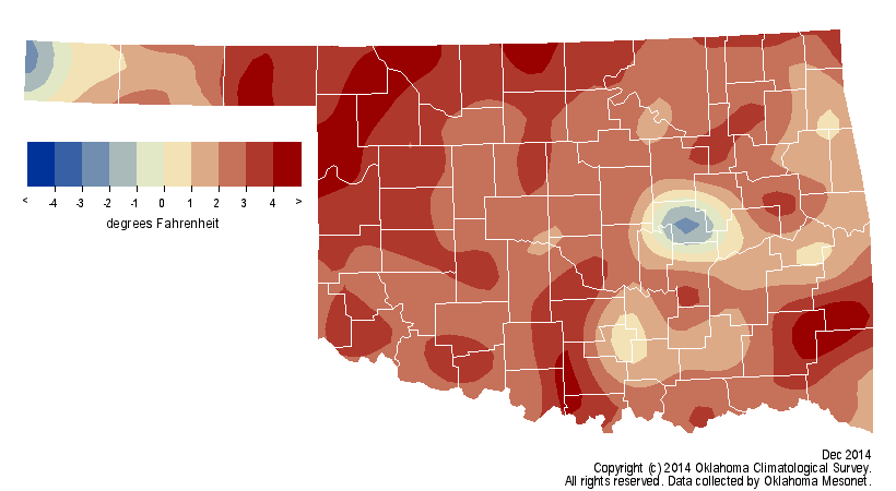
Winter was noticeably absent through much of December, a deceptively warm month
that ended more than 2 degrees above normal to rank as the 38th warmest since
records began in 1895.
http://ticker.mesonet.org/archive/20150104/dec-avg-temps.png
http://ticker.mesonet.org/archive/20150104/dec-dep-avg-temps.png
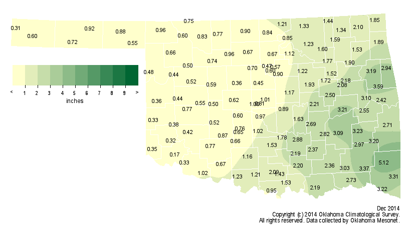
The season finally lived up to its name during the month's final week, however,
with a swath of 3-5 inches of snow along the I-44 corridor in southwestern
Oklahoma, along with another icy plunge to ring in the New Year. New Year's Eve
was celebrated with patches of freezing drizzle, snow, sleet and below-zero wind
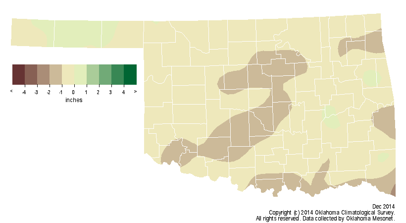
chills. Despite the snow and ice, preliminary data from the Oklahoma Mesonet
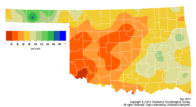
still tracked a deficit of 0.67 inches for the month, the 55th driest December
on record.
http://ticker.mesonet.org/archive/20150104/dec-precip-totals.png
http://ticker.mesonet.org/archive/20150104/dec-pct-normal-precip.png
http://ticker.mesonet.org/archive/20150104/dec-precip-depart-normal.png
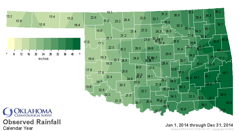
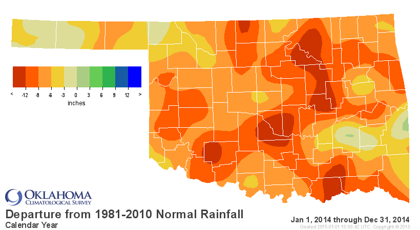
The year itself was cool and dry as a whole, with 2014's statewide average
temperature at 58.9 degrees, one degree below normal and the 27th coolest on
record. The January-December statewide average precipitation total of 28.47
inches was more than 8 inches below normal and the 26th driest year on record.
The 2014 Mesonet precipitation totals ranged from 13.2 inches at Kenton while
Clayton had the most with 50.9 inches.
http://ticker.mesonet.org/archive/20150104/2014-precip-totals.png
http://ticker.mesonet.org/archive/20150104/2014-depart-normal-precip.png
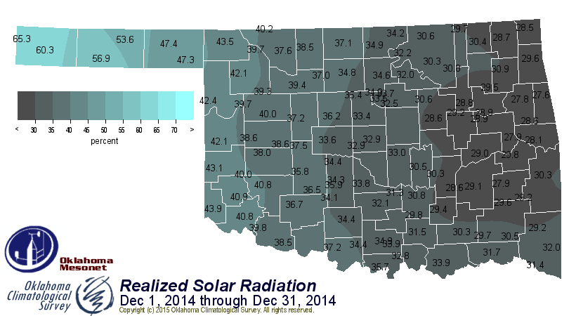
December's average temperature might have finished on the warm side, but that
statistic didn't come with lots of warm, sunny days. In fact, it was the least
sunny December since Mesonet records began in 1994, receiving only 35 percent
of possible sunshine.
http://ticker.mesonet.org/archive/20150104/srad.201412.png
Fog was a frequent visitor throughout the month, and the high humidity values
aided in suppressing fire danger. The clouds and moisture also helped account
for the warmth, trapping heat close to the surface at night and preventing the
low temperatures from plummeting. The statewide average high temperature, held
down by the cloudiness, was actually more than a degree below normal, but the
average low temperature was nearly 6.5 degrees above normal. The highest
temperature recorded by the Mesonet in December was 75 degrees at Burneyville
on the fifth. The lowest temperature, minus 6 degrees, came on the month's
final day at Kenton. The lowest temperature of 2014 was minus 12 degrees at
Nowata back on January 6, and the highest temperature of 107 degrees came on
July 26 at Freedom.
Severe weather made an appearance during the month, including a weak tornado
near Lake Arcadia in central Oklahoma on the 14th, only the 25th December
tornado since 1950. According to preliminary data from the National Weather
Service (NWS), 2014 ended with a total of 16 tornadoes, the lowest count since
accurate records began in 1950. If that total holds at 16, it would best the
previous minimum count of 17 back in 1988.
http://www.srh.noaa.gov/oun/?n=tornadodata-ok-monthlyannual
Large hail and severe winds also accompanied the storms on the 14th.
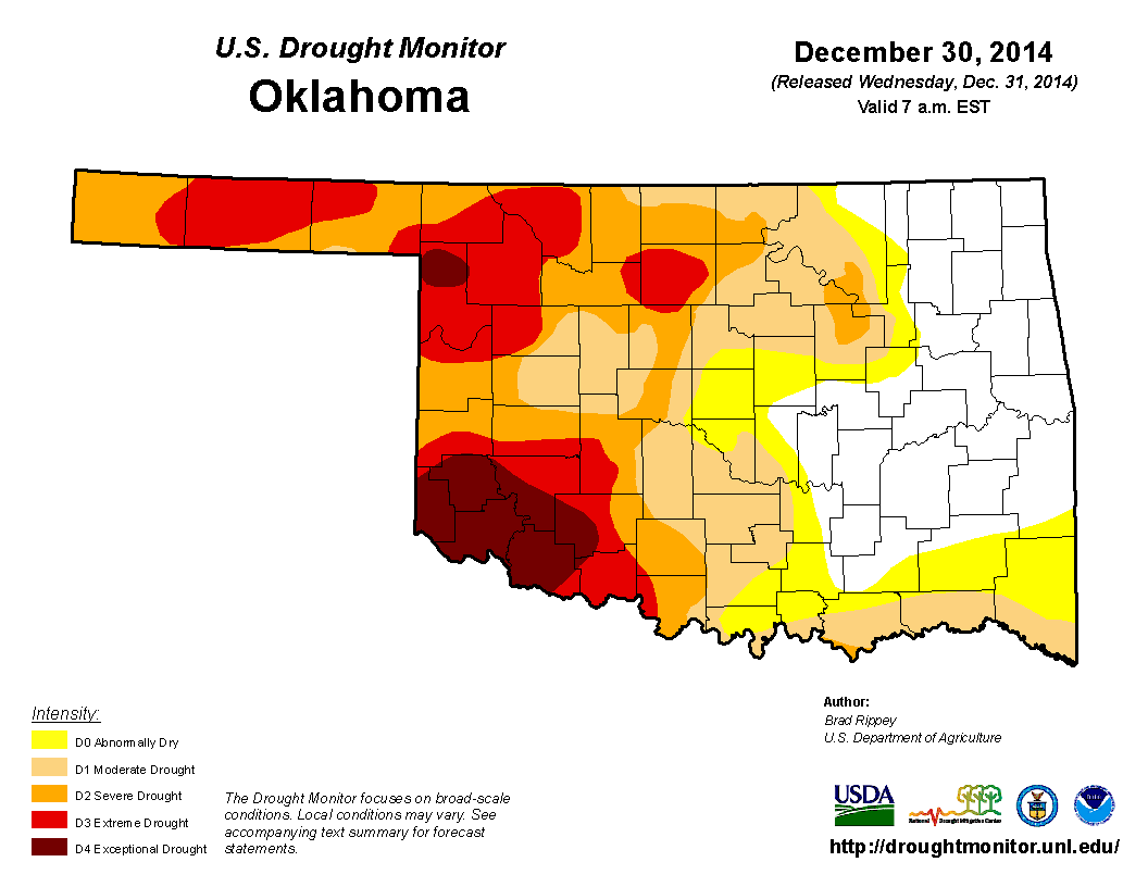
No drought improvements were noted during the month thanks to the dry
conditions. The U.S. Drought Monitor depicted 60 percent of the state in
drought to start December and 62 percent as it ended. The amount of
extreme-to-exceptional drought, the worst two categories on the Drought
Monitor, increased from 18 percent to 22 percent. Nearly 1.5 million Oklahomans
were still affected by drought as the year came to a close.
http://ticker.mesonet.org/archive/20150104/dec2-droughtmonitor.png
http://ticker.mesonet.org/archive/20150104/dec30-droughtmonitor.png
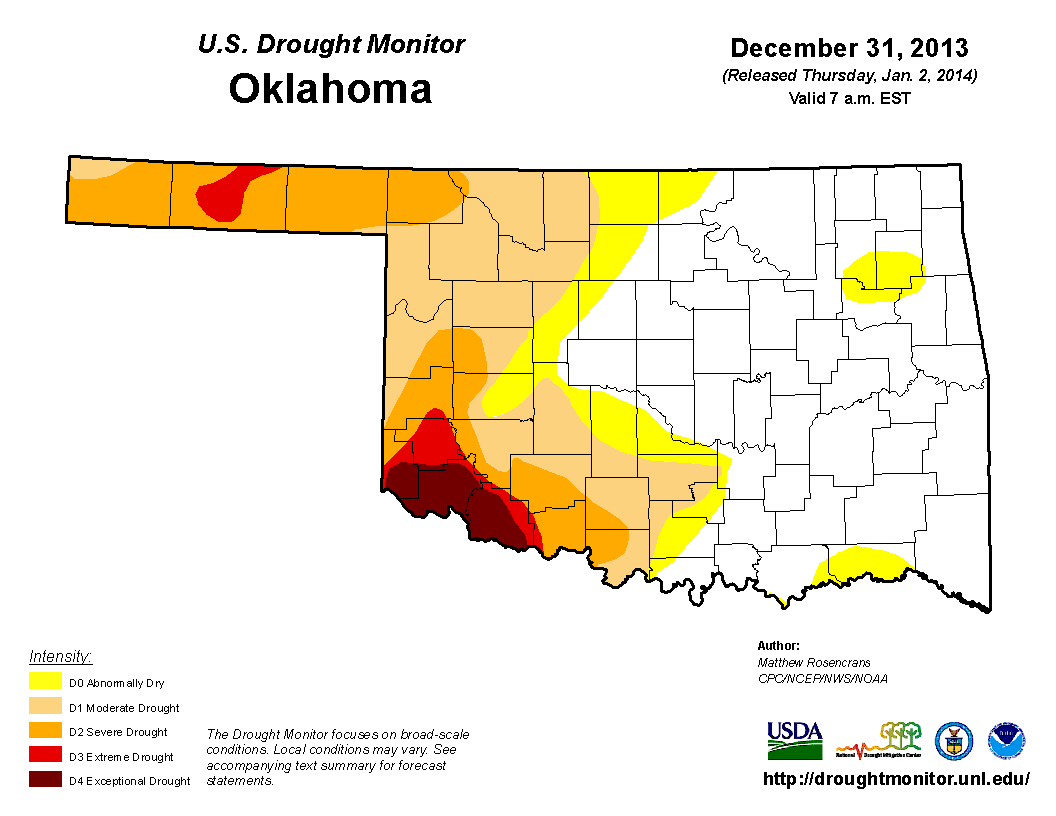
One year ago, 38 percent of the state was considered to be in drought.
http://ticker.mesonet.org/archive/20150104/dec31-2013-droughtmonitor.png
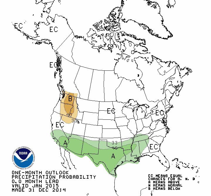
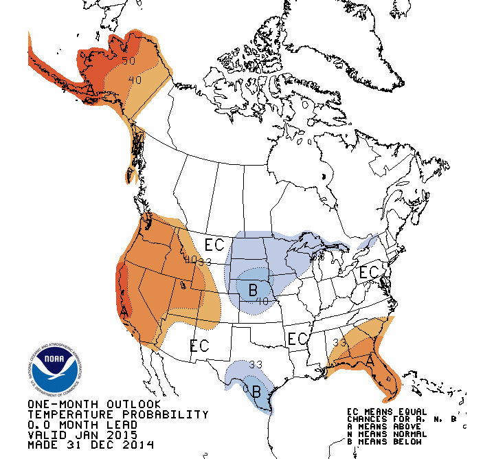
The latest outlooks for January from the NWS' Climate Prediction Center (CPC)
show increased odds of above normal precipitation across the southern two-thirds
of the state, but no clear signal for temperature.
http://ticker.mesonet.org/archive/20150104/jan-precip-outlook.gif
http://ticker.mesonet.org/archive/20150104/jan-temp-outlook.gif
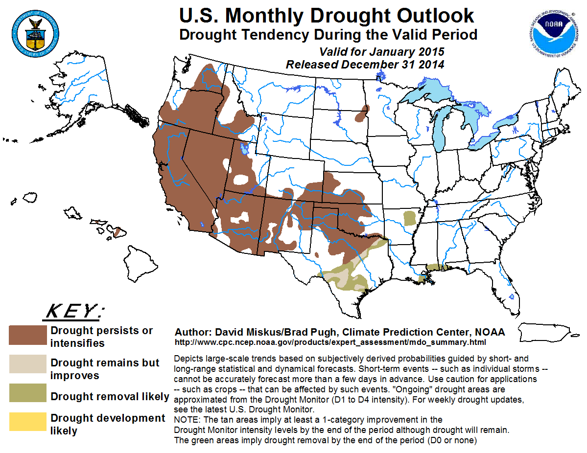
CPC's U.S. Monthly Drought Outlook for January sees drought persisting or
intensifying across those areas where drought is already in place, but no
development in the current drought-free areas.
http://ticker.mesonet.org/archive/20150104/january-drought-outlook.png
Gary McManus
State Climatologist
Oklahoma Mesonet
Oklahoma Climatological Survey
(405) 325-2253
gmcmanus@mesonet.org
==================================================
The OCS/Mesonet Ticker
https://ticker.mesonet.org/
To subscribe or unsubscribe from the Ticker
or for questions about the Ticker or its content
Phone or Email the Ticker Manager at OCS
Phone: 405-325-2253 Email: ticker@mesonet.org
---------------------------------------------------
-C- Copyright 2024 Oklahoma Climatological Survey
===================================================
|


 Tweet
Tweet