Ticker for May 19, 2025
MESONET TICKER ... MESONET TICKER ... MESONET TICKER ... MESONET TICKER ...
May 19, 2025 May 19, 2025 May 19, 2025 May 19, 2025
Risky bidness

I'm off today (it's okay, I'm seeking help for it), but I just had to give a quick
Tick to Tock about a possible significant (is there any other kind?) outbreak of
severe weather today from early afternoon through the evening. I won't bore you
(HAHA, verrrry funny) with the complicated setup, so here's a watered down
version (hey, "Watered Down Version" is the name of my Taylor Swift tribute band's
last album!) of how today could POSSIBLY unfold:
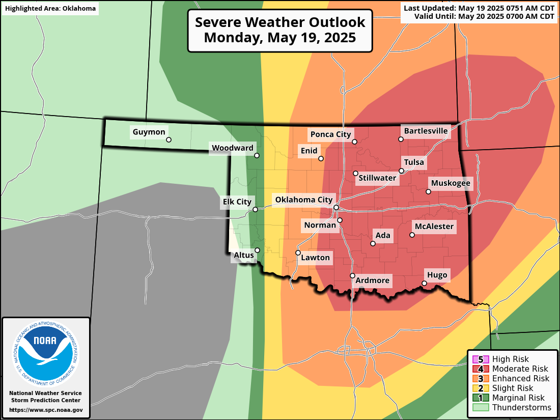
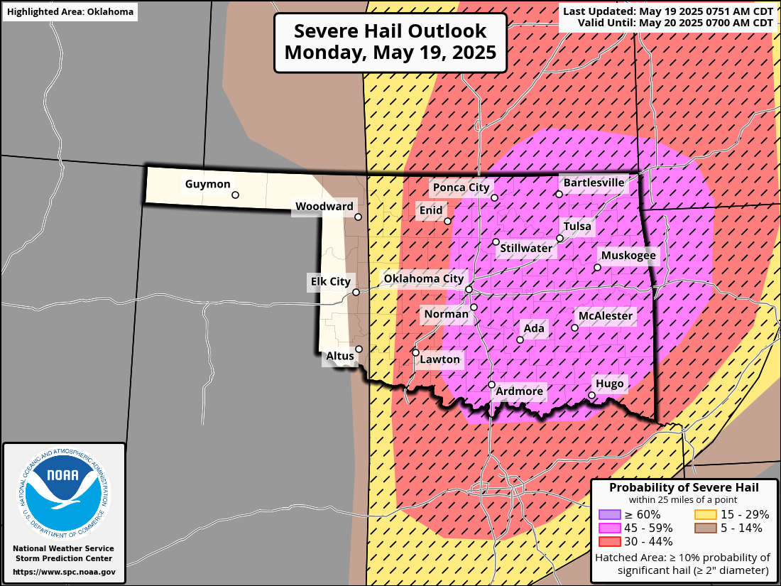
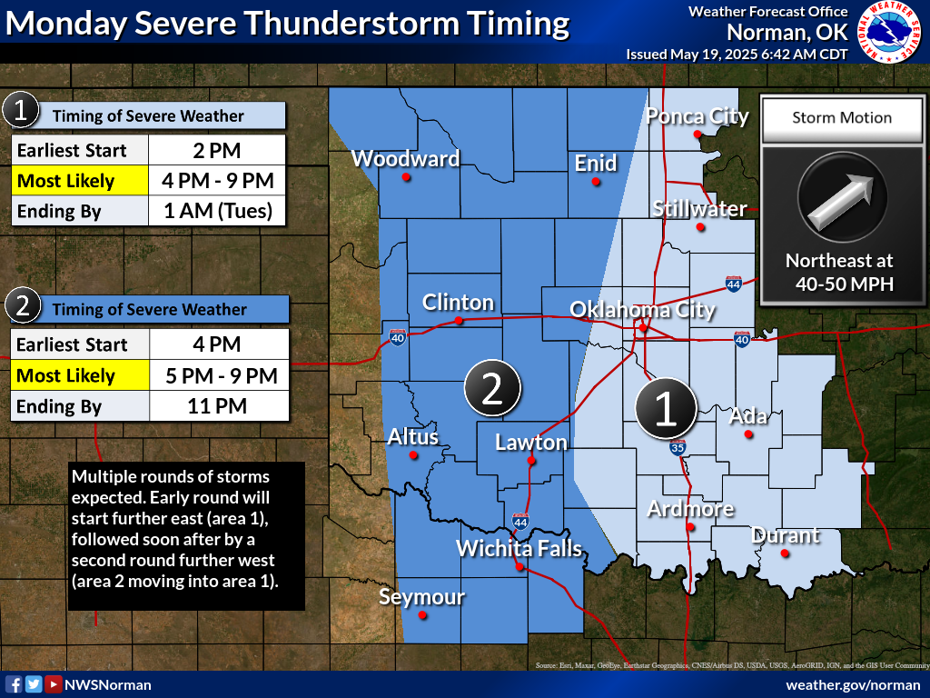
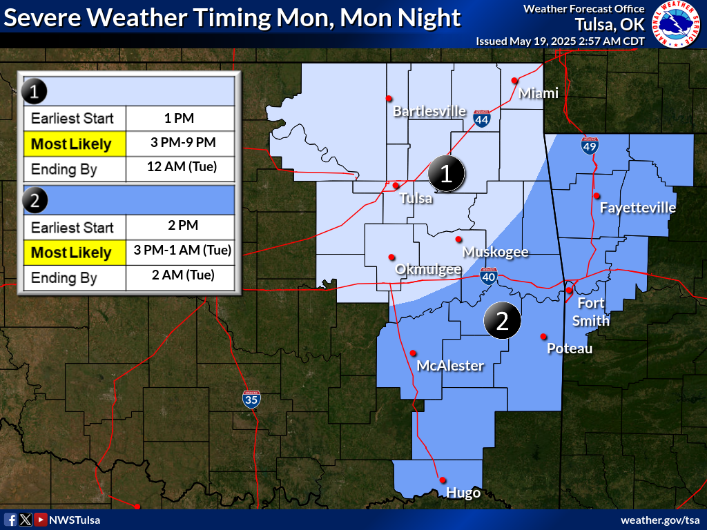
We are expecting multiple rounds of severe storms to form today in this moisture-
rich environment. The atmosphere will be extremely unstable, with hot, humid air
and strong winds at different levels of the atmosphere helping fuel the storms.
Thunderstorms could begin as early as midday, especially in eastern Oklahoma,
with the potential to produce large hail, damaging winds, and strong tornadoes.
Later this afternoon, another wave of powerful storms is expected to form along
the dryline in western Oklahoma and Texas, bringing additional threats of very
large hail and tornadoes. With so many storms in such an unstable environment,
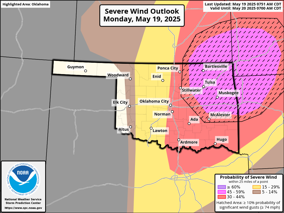
damaging winds are also a major concern, particularly in northeast Oklahoma and
nearby regions.
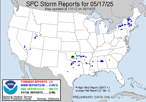
So you gotta stay weather aware today. I mean, yesterday was actually fairly
quiet across all but NW OK, but even then we had 3-4 tornadoes and DVD-size
(yes, DVD) hail up to 5 inches (yes, 5 inches) near Arnett. Now I used to be
not-so-fond of Arnett since they would beat us in baseball pretty regularly
back in my day (GO BUFFALO GO GO GO!), but I've softened and hated to see the
good folks up that way get hit so hard. NE OK got hit pretty hard too by wind
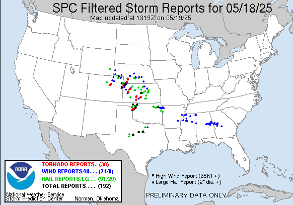
and giant hail. And Saturday was no picnic with more possible twisters and
softball size hail.
Golf ball size hail will put knots on your noggin faster'n you can rub 'em, but
DVD size hail will kill ya, no ifs and or butts. Buts too...keep it clean, this
is a family Ticker.
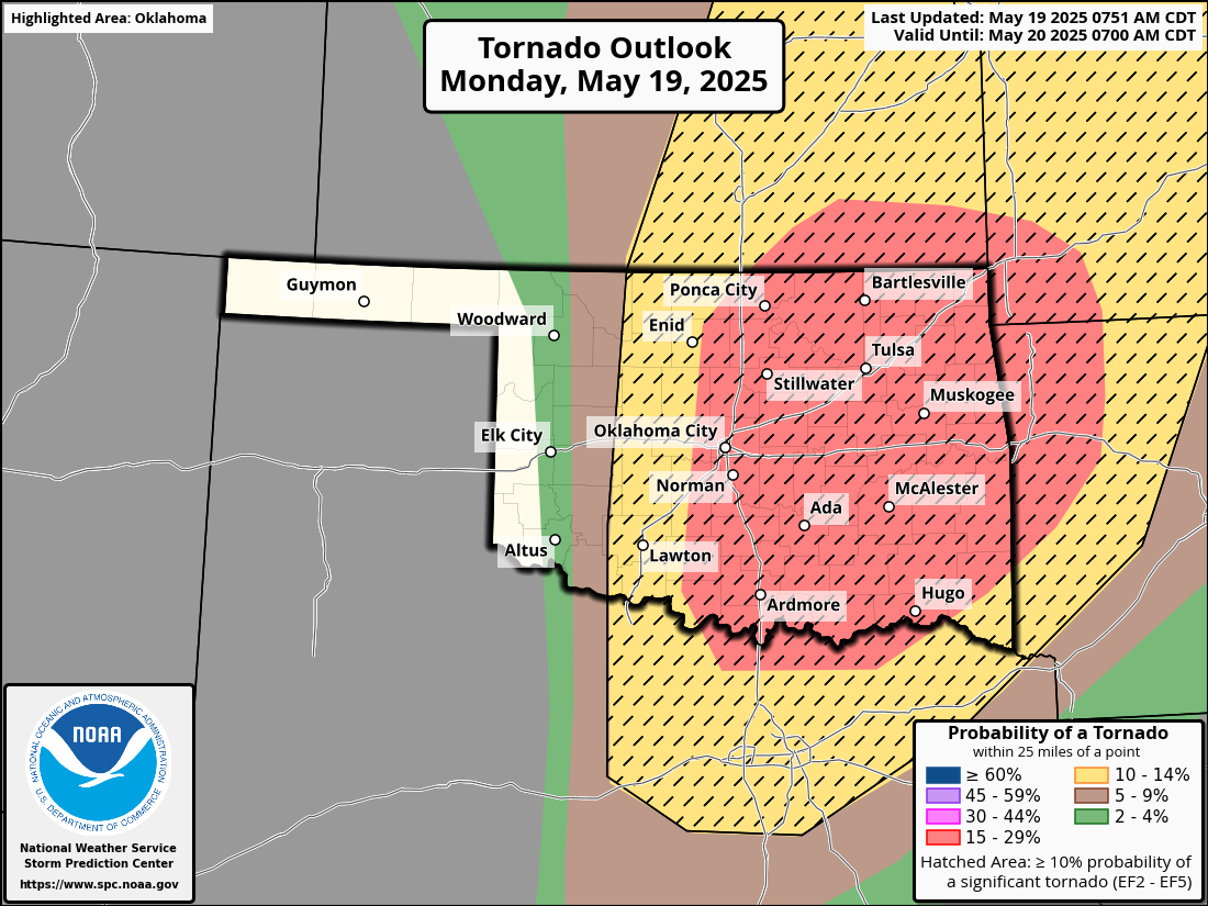
Basically, you gotta watch the warm sector across eastern OK early afternoon for
supercells, then a bit later watch along the dryline for a more classic setup
for western/central Oklahoma...the dreaded Highway 81 Powderkeg scenario.
Here are the individual outlooks a bit closer up so you can clearly see the
counties, but remember...if you are in one of the colored areas, you are at
risk.
This is weird (and you know weird because you're reading him), but the timing
for eastern OK before western OK is throwing me off, but that's okay because
as I said earlier, I'm off today.
Okay, you gotta stay weather aware today from lunch onwards. Have a plan if
you and yours are in the path of storms. People died during more significant
severe weather in other states the last few days, and that more significant
severe weather is now aimed directly at Oklahoma. We'll hope for a more benign
day, but we don't want to add to those numbers.
Here's a more detailed list of things you can do to keep you and your loved
ones safe today in the face of possible significant severe weather:
1. Stay Weather Aware All Day
Monitor reliable sources like your local National Weather Service
office, TV meteorologists, NOAA Weather Radio, or weather apps.
Don’t rely solely on outdoor sirens — they’re not designed to be heard
indoors.
2. Know Your Risk Areas
Stay especially alert if you live in central, eastern, or northeastern
Oklahoma, where the highest threat exists today.
Check if your county is under a Tornado Watch or Severe Thunderstorm
Watch — these may be issued before storms begin.
3. Have Multiple Ways to Get Alerts
Make sure Wireless Emergency Alerts (WEA) are enabled on your phone.
Have a NOAA Weather Radio as a backup.
Follow your local emergency management on social media for real-time
updates.
4. Review Your Tornado Safety Plan
Know where your safe place is: a storm shelter, basement, or small
interior room on the lowest floor, away from windows.
If you live in a mobile home or temporary structure, have a plan to get
to a sturdier building quickly.
5. Prepare Your Emergency Kit
Flashlight, batteries, phone charger (and backup battery), water,
snacks, shoes, weather radio, medications, ID, and important documents.
Include helmets (bike or sports helmets) for everyone in the household
if tornadoes are expected.
6. Keep Vehicles Fueled and Phones Charged
Power outages are possible from damaging winds or tornadoes.
7. Stay Off the Roads During Warnings
Don’t try to “outrun” a tornado. Shelter in place unless you’re
evacuating a mobile home to a safer location.
If caught outside or in a car with no other options, try to get to a
ditch or low-lying area and cover your head, but this is a last resort.
8 Check In With Family and Neighbors
Especially those who are elderly or have mobility issues — make sure
they know the forecast and have a plan.
9. Stay Calm, Take Action
Don’t panic — if you’ve prepared ahead of time, you’ll be in the best
position to protect yourself and your loved ones.
Gary McManus
State Climatologist
Oklahoma Mesonet
Oklahoma Climate Survey
gmcmanus@ou.edu
May 19 in Mesonet History
| Record | Value | Station | Year |
|---|---|---|---|
| Maximum Temperature | 107°F | ALTU | 2022 |
| Minimum Temperature | 32°F | KENT | 2019 |
| Maximum Rainfall | 5.33 inches | BOWL | 2017 |
Mesonet records begin in 1994.
Search by Date
If you're a bit off, don't worry, because just like horseshoes, “almost” counts on the Ticker website!