Ticker for April 1, 2025
MESONET TICKER ... MESONET TICKER ... MESONET TICKER ... MESONET TICKER ...
April 1, 2025 April 1, 2025 April 1, 2025 April 1, 2025
Yes, this is a non-April Fools severe weather outlook by yours truly, an year-
round fool. I wish it were an April Fools joke, because it's one of THOSE days
in Oklahoma. One of those days where you get up in the morning and even your
Cherry Pop-Tarts don't look as appetizing because you know what can happen later
today with the weather, so you just go with Strawberry because you know you
wouldn't enjoy it anyway, so why waste the good stuff?
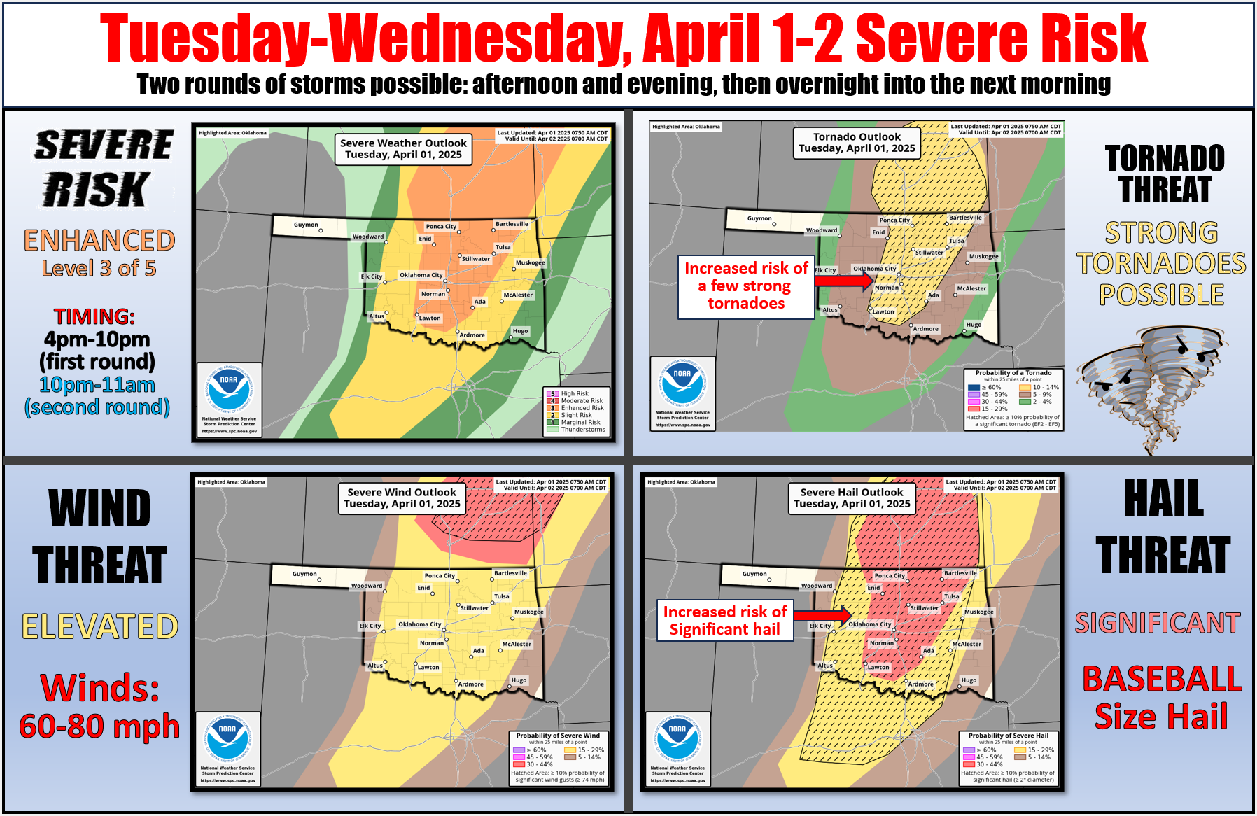
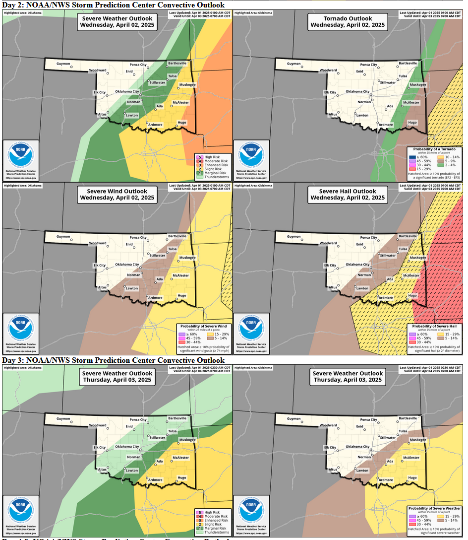
Here's the scenario: powerful low pressure system this afternoon tracking across
NW OK into KS, dragging a dryline and front with it. Storms could fire up along
the dryline this afternoon along the enhanced convergence of the dryline and
strong heating (increasing instability), but there are limiting factors. Namely,
the often-limiting temperature inversion, or cap, above the surface. However,
if storms do form, the shear and energy are there to wreak a bit of havoc with
WIDELY SCATTERED storms.
So first storms have to form, then you have to be unlucky enough to be in one's
path. So your chances of anything bad are pretty darned low, but be prepared
with those safety plans regardless.
Then storms are more likely overnight as the front comes through, and once again
given the shear and instability, all modes of severe weather will be possible.
Maybe earlier storms will spoil the environment and make the overnight versions
not as bad, but that's pretty iffy too.
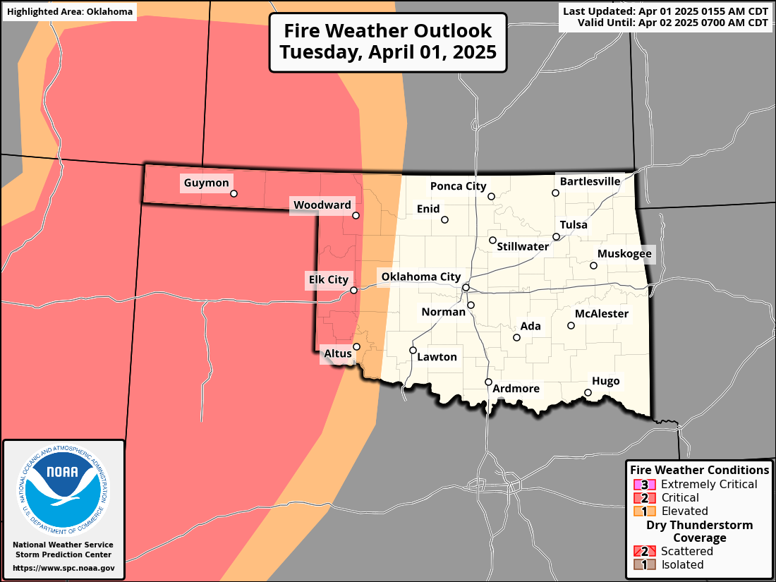
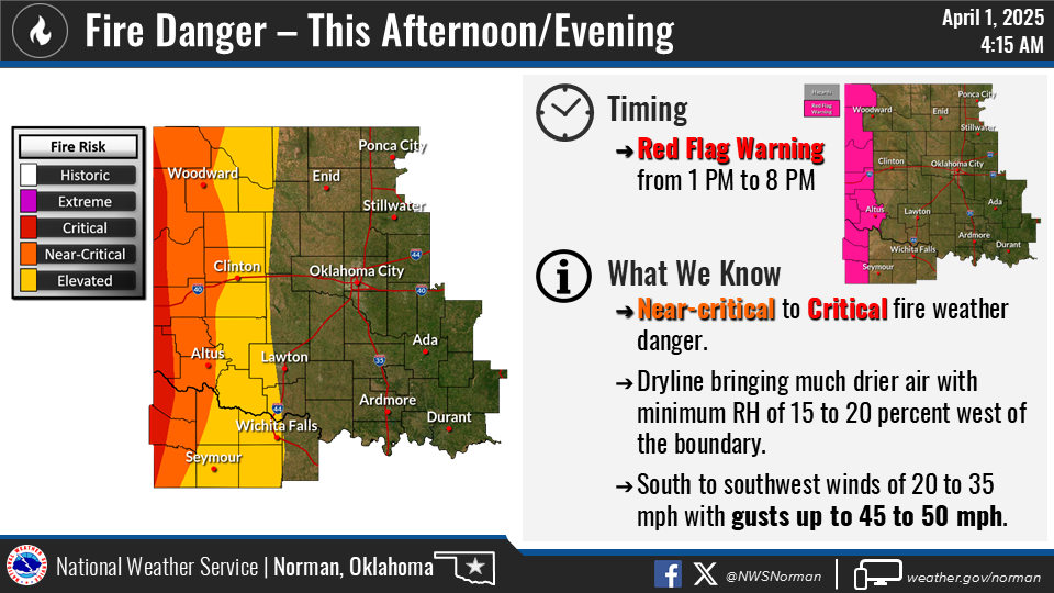
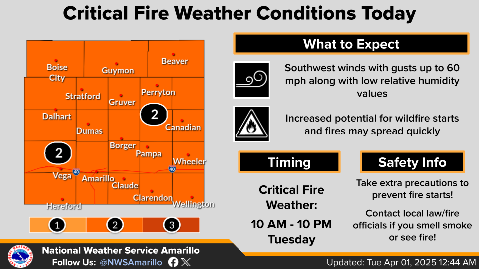
And on the back end of that dryline (and we all know just how painful that can
be), we'll see bigtime fire danger that ain't nothing to trifle with as winds
crank up to 45-60 mph and those humidities plummet.Everybody gets the nasty
winds, though.
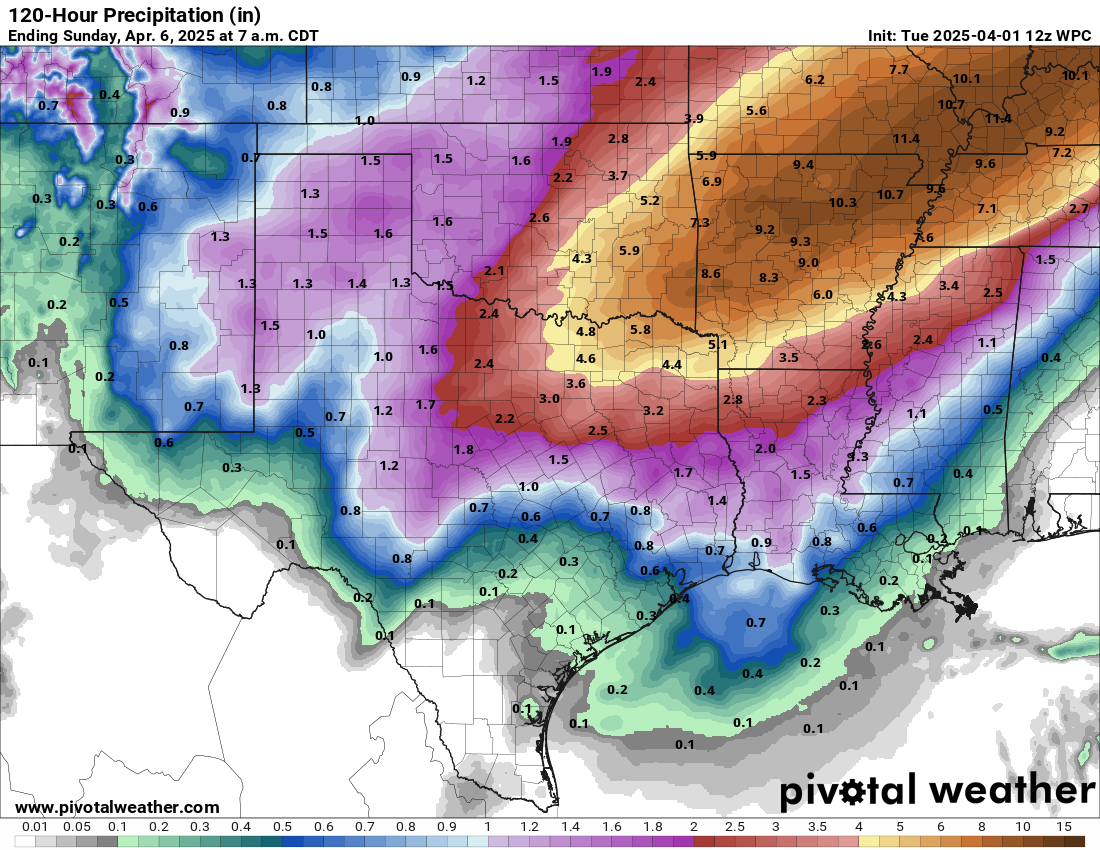
And it doesn't stop there, the fun continues for the next few days with more
chances of severe weather, mostly to the south and east, as well as more rain.
That's enough for now, ain't it? If you're a glutton for punishment, or even
a punisher of gluttons, stick around below and hear about our gruesome March.
---------------------------------------------------------------------------------
Devastating Wildfires Steal March Headlines
April 1, 2025
Most months, nearly breaking an all-time tornado record would dominate
Oklahoma’s weather headlines. However, March 2025 will be remembered for a
different kind of disaster—one of the worst wildfire outbreaks in state
history, overshadowing all else.
Dangerous fire weather conditions permeated the month—typical for Oklahoma’s
primary wildfire season in the late winter and early spring—fueled by dormant
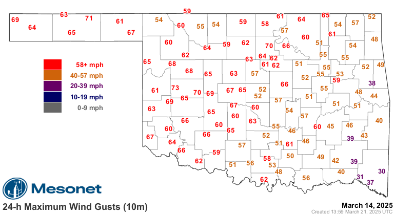
vegetation and frequent wind-driven storm systems. March 14 saw the worst of
those extreme conditions, with single-digit humidity and wind gusts exceeding
75 mph. The result was predictably devastating: fires burned out of control for
days, scorching more than 170,000 acres and destroying at least 530 homes and
businesses. The Oklahoma State Department of Health reported at least 200
wildfire-related injuries, including burns, cuts, falls, and transportation-
related incidents. Tragically, four fatalities were confirmed in Lincoln,
Garfield, Haskell, and Pawnee counties on what many are calling the worst
wildfire day in state history.
The March 14 firestorm was driven by historic non-thunderstorm winds, including
an 83-mph gust recorded at Frederick Airport just after 3 p.m. The Oklahoma
Mesonet recorded the most sites in its 31-year history measuring severe wind
gusts (58+ mph) in a single day—63 locations—shattering the previous record of
49 sites set on May 27, 2001. Mesonet wind data date back to Jan. 1, 1994. Those
unrelenting winds across the region created a dust storm reminiscent of the
Dust Bowl era, reducing visibility to near zero in some locations. The blinding
conditions led to multiple chain-reaction accidents on state highways, adding
to the day's devastation.
Oklahoma also saw at least 15 tornadoes during March, falling just short of the
record 17 set in 1991. Fourteen tornadoes touched down on March 4—the highest
single-day March total since records began in 1950—with one additional tornado
on March 15. All were rated EF0 or EF1 (“weak”) by National Weather Service
investigators.
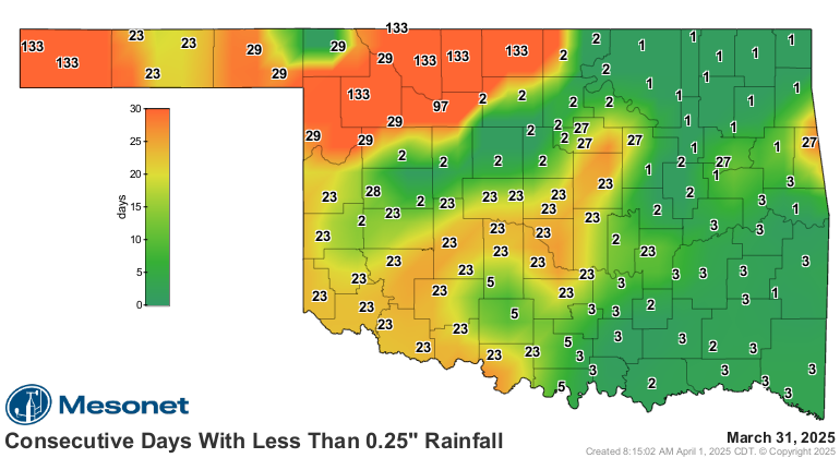
By the end of March, portions of northwestern Oklahoma had endured 133
consecutive days without receiving at least a quarter-inch of rain in a single
day, dating back to mid-November. The persistent dry and warm conditions fueled
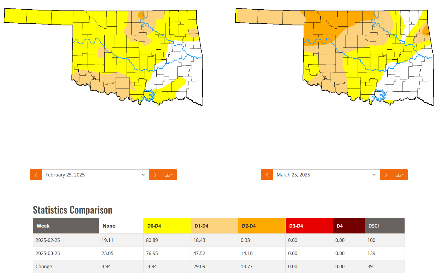
a resurgence of drought across western and northern Oklahoma. According to the
U.S. Drought Monitor, drought coverage expanded from 18% of the state at the
end of February to 48% by the end of March, with severe drought surging from
just 0.33% to more than 14% during that period.
March by the Numbers:
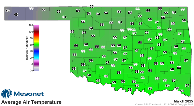
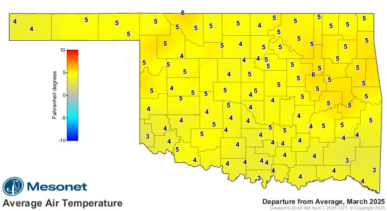
• Statewide average temperature: 56°F (4.8°F above normal), the seventh-warmest
March since records began in 1895.
• Temperature extremes: High of 91°F at several locations (March 18 and 25);
low of 18°F at several locations (March 5 and 16).
• High temperatures above 80°F: 819 instances recorded at the 119 Oklahoma
Mesonet sites, including seven readings above 90°F.
• Low temperatures below 32°F: 545 instances, including five readings below
20°F.
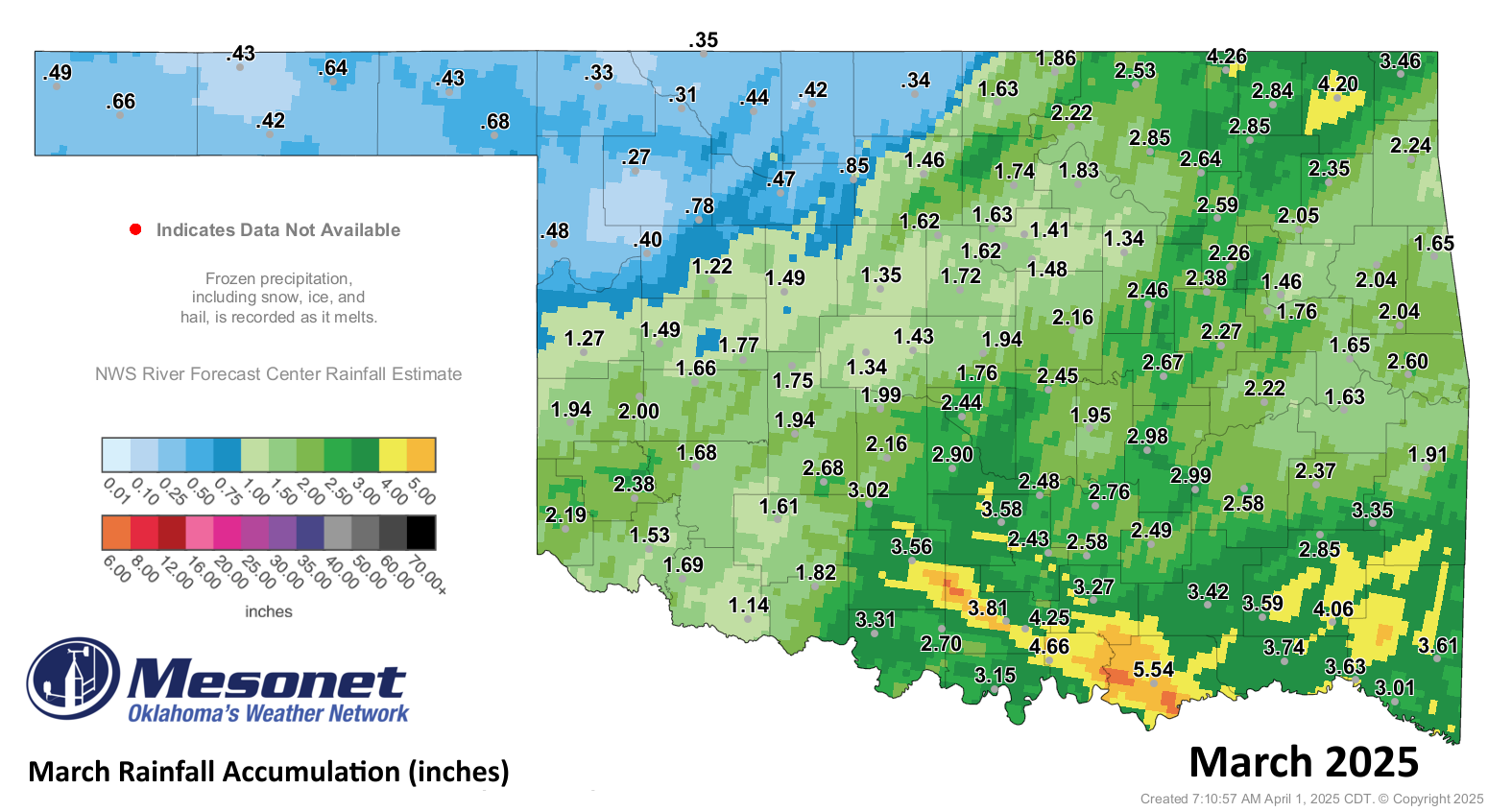
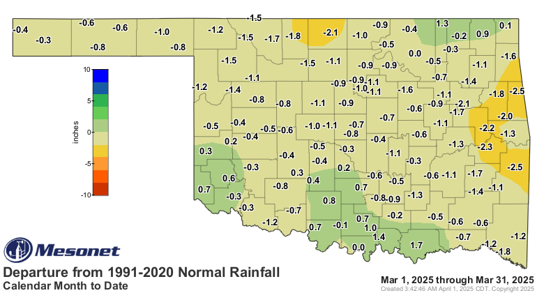
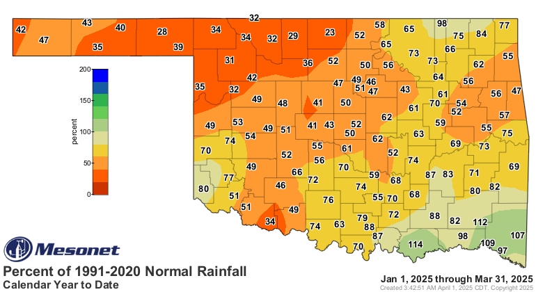
• Statewide average precipitation: 2.00 inches (0.78 inches below normal),
ranking as the 50th-driest March on record.
• Rainfall extremes: High of 5.54 inches at Durant; low of 0.27 inches at
Woodward.
• Precipitation deficits: Ranged from 0.5 to 1.5 inches across much of the
state, with localized deficits of 1.5 to 2.5 inches in north-central and
east-central Oklahoma.
January-March by the Numbers:
• Statewide average temperature: 43.2°F (0.8°F below normal), the 54th-warmest
such period on record.
• Temperature extremes: Low of -17°F at Eva (Jan. 20); high of 91°F (March 18
and 25).
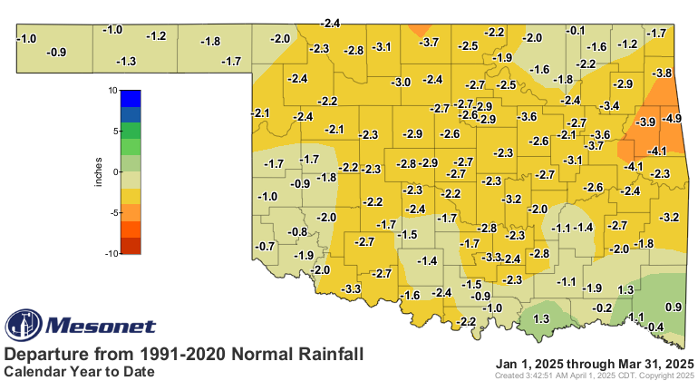
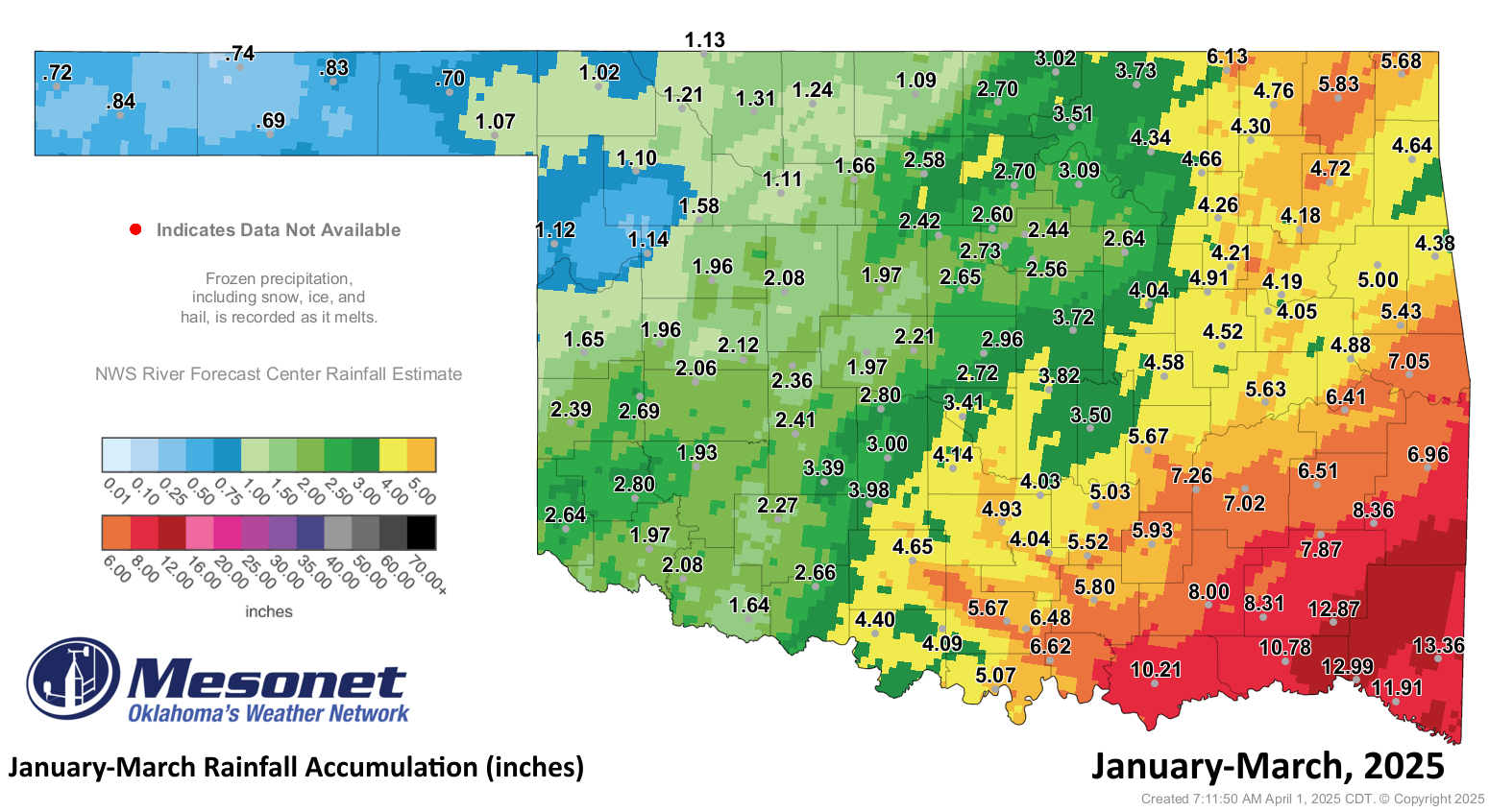
• Statewide average precipitation: 3.89 inches (2.15 inches below normal), the
32nd-driest such period on record.
• Rainfall extremes: High of 13.36 inches at Broken Bow; low of 0.69 inches at
Goodwell.
Looking Ahead:
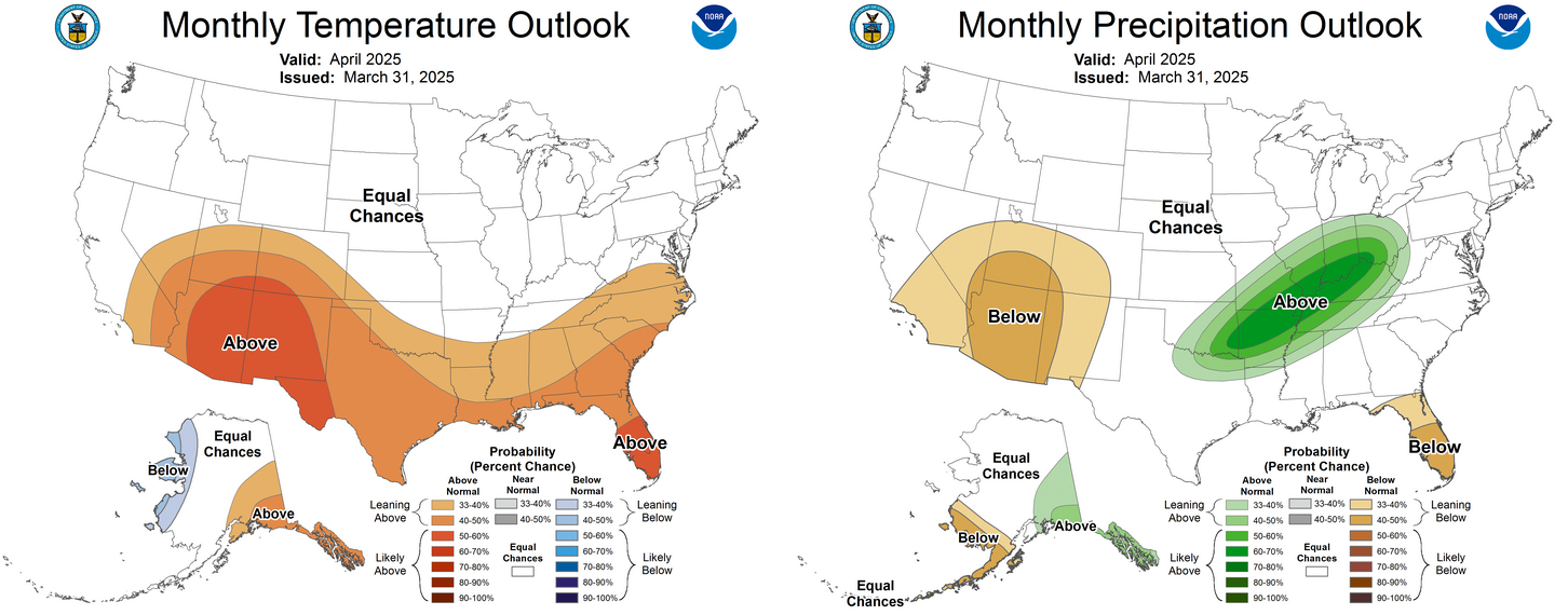
The Climate Prediction Center’s outlooks for April indicate increased odds of
above-normal temperatures across the southwestern two-thirds of the state, with
the highest likelihood in the far southwest. There is also a greater chance of
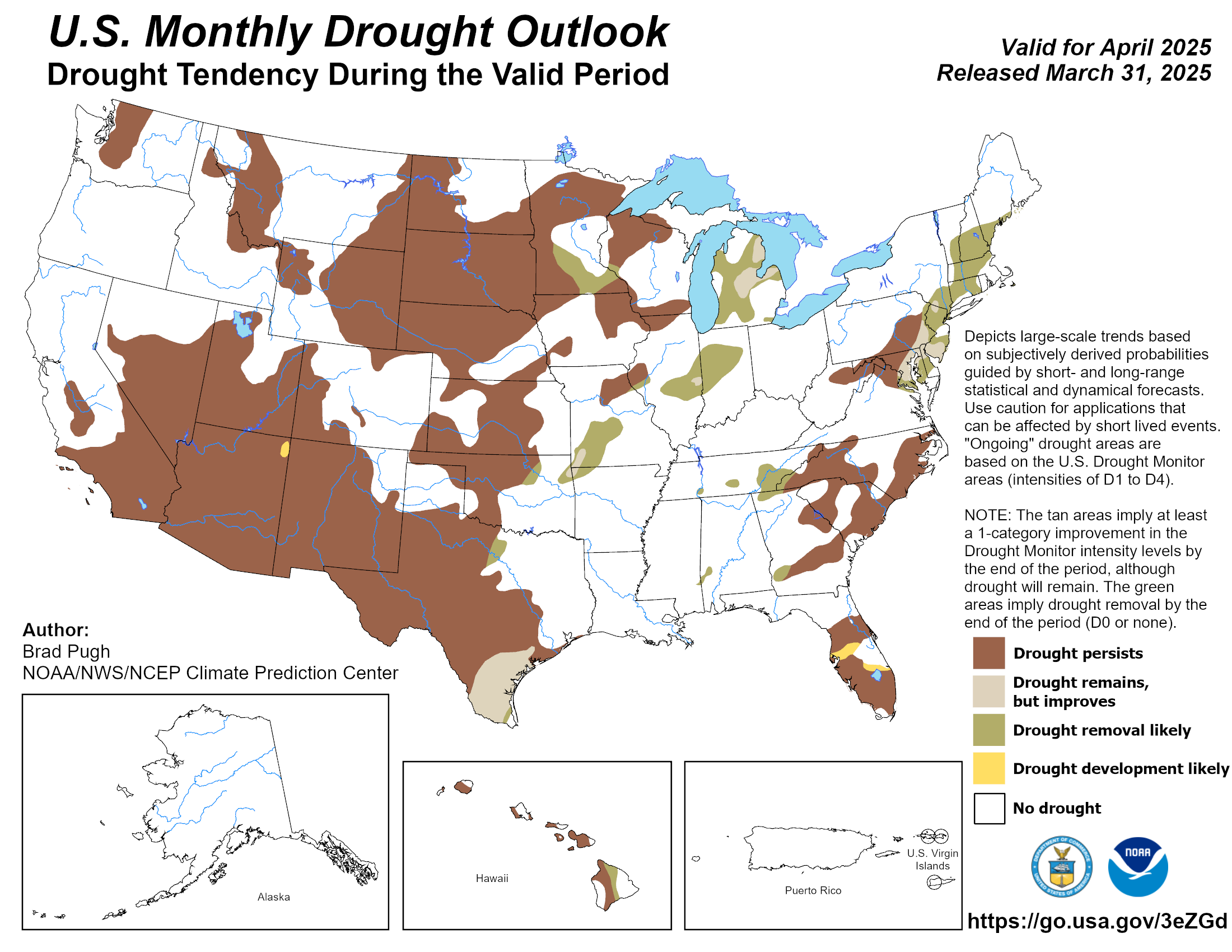
above-normal precipitation in the southeastern half. As for drought, the April
outlook suggests it may persist in most areas where it currently exists but
improve along the eastern edges, where removal is favored.
###
Gary McManus
State Climatologist
Oklahoma Mesonet
Oklahoma Climate Survey
gmcmanus@ou.edu
April 1 in Mesonet History
| Record | Value | Station | Year |
|---|---|---|---|
| Maximum Temperature | 98°F | ALTU | 2012 |
| Minimum Temperature | 19°F | EVAX | 2023 |
| Maximum Rainfall | 2.57 inches | TIPT | 2006 |
Mesonet records begin in 1994.
Search by Date
If you're a bit off, don't worry, because just like horseshoes, “almost” counts on the Ticker website!