Ticker for February 22, 2024
MESONET TICKER ... MESONET TICKER ... MESONET TICKER ... MESONET TICKER ...
February 22, 2024 February 22, 2024 February 22, 2024 February 22, 2024
El Nino magic!
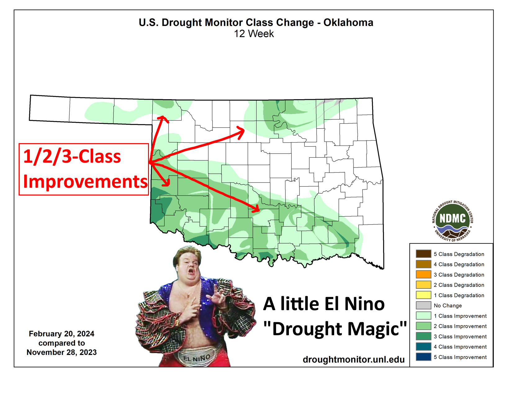
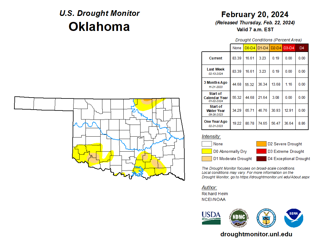
When I filmed our Mesonet Weather segment for "SUNUP" (which airs on OETA weekend
mornings) yesterday, I called these little drought areas left in the state as
"dollops." I'm not even gonna Okie-translate that, since if you want to know what
a dollop is, just look at my scalp and my "dollop" of hair left. However,
heretofore, and therein...we're talking about how a little bit of El Nino magic
has ALMOST gotten drought out of the state entirely--at least by the U.S. Drought
Monitor's standards--for the first time since July 16, 2019. That's nearly
four years ago! But maybe not coincidentally, during our last El Nino event.
Anyway, the 3.23% we DO have left is again the lowest level we've seen since,
uhhhhhh, last week. But before that, since Aug. 17, 2021, which was what I would
consider the beginning of the 2+ year severe drought episode we're coming out
of.
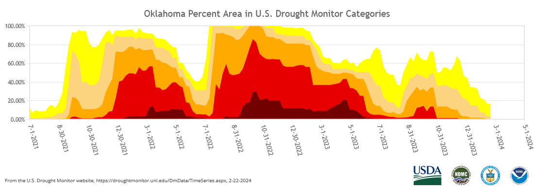
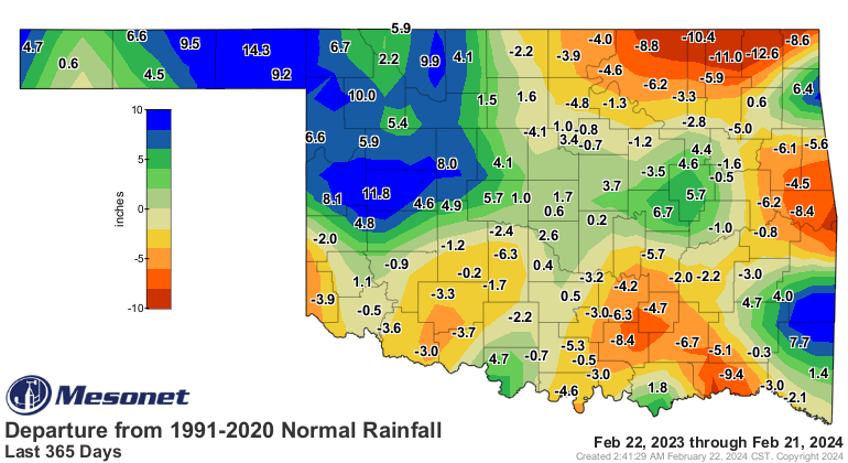
I'm not willing to say this drought event is over just yet BECAUUUUSSSE we still
have long-term deficits underlying the last 3-6 months of relief.
Hey, I'm also not willing to say "Caddyshack 2" was better as a movie as
Strawberry Pop-Tarts are as an, ummm, Pop-Tart, but THAT DON'T MAKE IT RIGHT!
Seriously though, comparing the two is like trying to determine the top turd
on the dungpile. Yes...SCIENCE!
At any rate, when you look at Oklahoma's drought record since 2000 on the
Drought Monitor, you see lots of stops and starts and interruptions and
whatnot, and those often (again not coincidentally) coincide with the arrival
of El Nino and La Nina episodes.
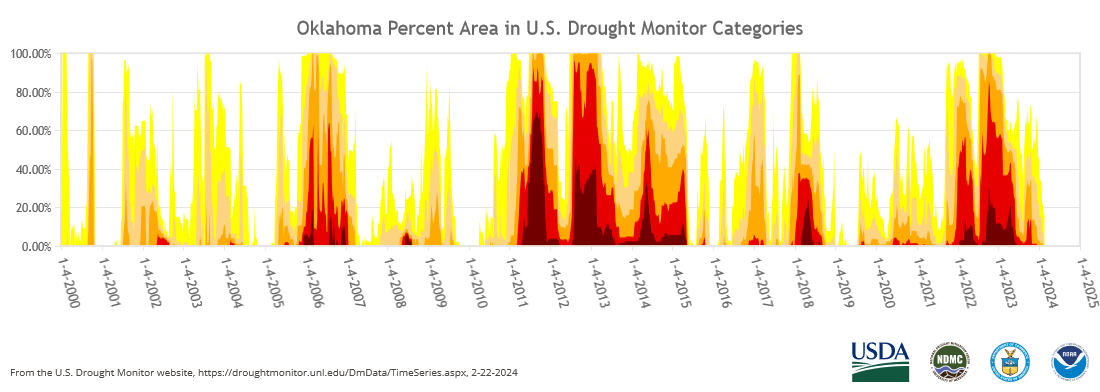
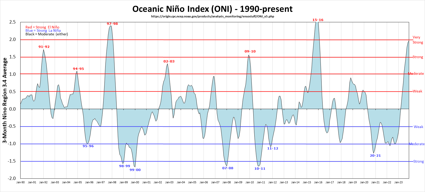
If you're thinking to yourself "Wow Gary, we seem to be in drought a lot!"
then you are correct. My depleted drought magic markers agree with you.
You're not correct to continue to think your name is Gary in your head, because
that name is reserved for only the most awesomest of people, but that's another
story. And yes, we are in drought a lot because we are in La Nina a lot thanks
to some favorable (for La Nina, not for us) conditions in the Pacific. And to
compound things, weak El Nino's also don't do us any favors either.
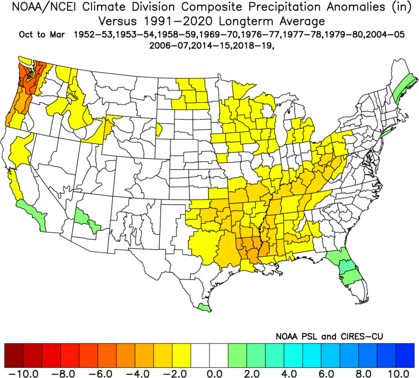
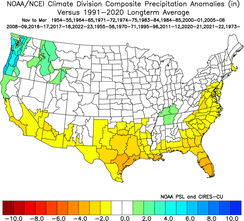
But those strong to super-strong El Ninos, like we've been flirting with all
this cool season, work wonders for relieving drought. And the cool season is
a perfect time to relieve drought since evaporation is so low and the use
by plants AND us humans (I include myself in that category, but loosely) is
much less than during the warm season. So what falls can generally stick around
longer, saturate soils, fill ponds and reservoirs, etc.
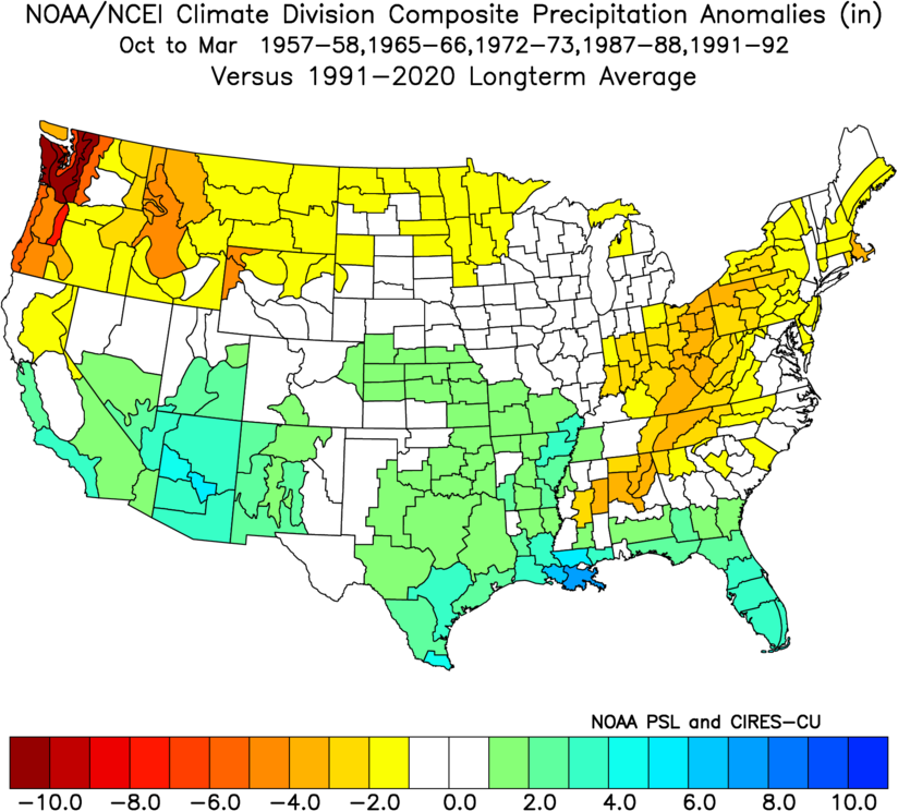
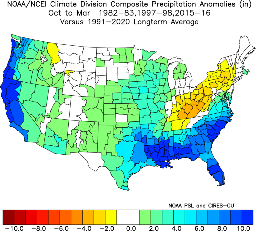
The common caveats with ENSO still apply: not all El Ninos nor La Ninas are the
same, nor are their impacts. But the tilting of the odds can and more-often-than
not tilt our odds towards their favored outcomes.
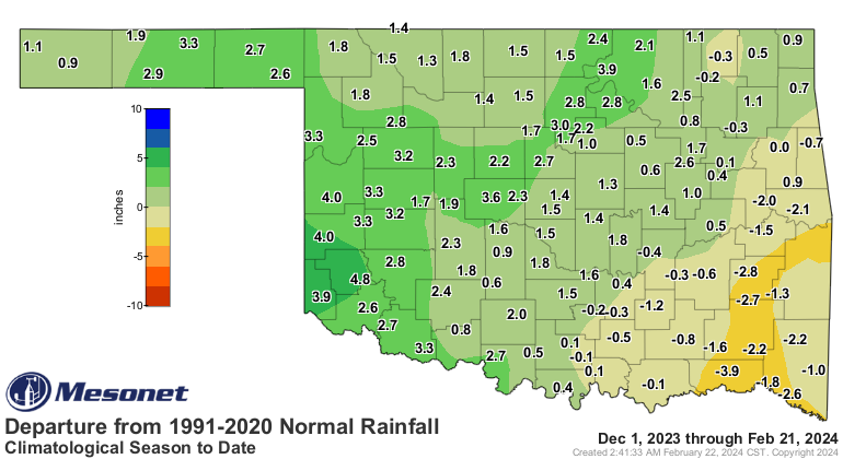
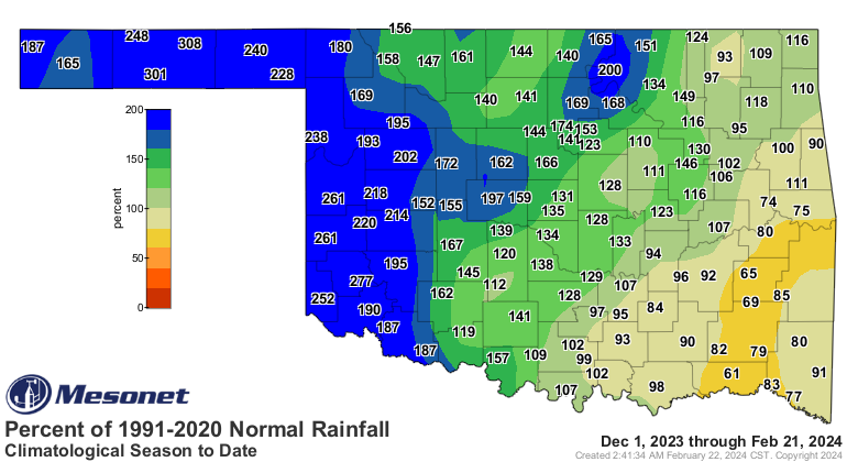
Not everybody gets the fine nuances of ENSO events and their impacts, how they
differ (or not exist at all) during the different seasons, and how they can
only influence forecasts, not guarantee them. There are always exceptions,
and exceptions to those exceptions. If you have exceptions to exceptions to
exceptions, then nothing really matters anymore. However, keep that in mind
when I tell you that La Nina has followed strong El Ninos a majority of the
time since 1950 (5 out of 8) the following cool season.
And that is what is forecast to occur this year as we get into next fall and
winter. Maybe earlier, but again, El Nino and La Nina impacts for us during
the summer are basically non-existent. But, come next cool season, we could
possibly once again see drought be favored across the Southern Tier of the
U.S., including Oklahoma.
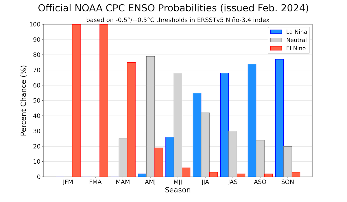
Favored. Tilted odds. Weighted dice. NOT guaranteed. And remember, we still
have those long-term deficits weighing the ecosystem down. The soils and
vegetation have a long drought-memory, so it doesn't take much to reignite
another stanza of our current almost-dead drought event. We don't see much
help in the next 7 days, but not to worry just yet.
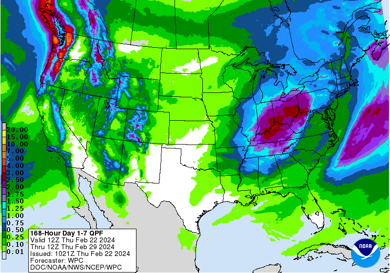
El Nino is still in charge, for another month or two at least. That bodes
well for spring. NOT guaranteed, though.
Gary McManus
State Climatologist
Oklahoma Mesonet
Oklahoma Climatological Survey
gmcmanus@mesonet.org
February 22 in Mesonet History
| Record | Value | Station | Year |
|---|---|---|---|
| Maximum Temperature | 86°F | HOLL | 2017 |
| Minimum Temperature | -2°F | HOOK | 2013 |
| Maximum Rainfall | 2.74 inches | BROK | 2018 |
Mesonet records begin in 1994.
Search by Date
If you're a bit off, don't worry, because just like horseshoes, “almost” counts on the Ticker website!