Ticker for August 1, 2022
MESONET TICKER ... MESONET TICKER ... MESONET TICKER ... MESONET TICKER ...
August 1, 2022 August 1, 2022 August 1, 2022 August 1, 2022
Jaugust?
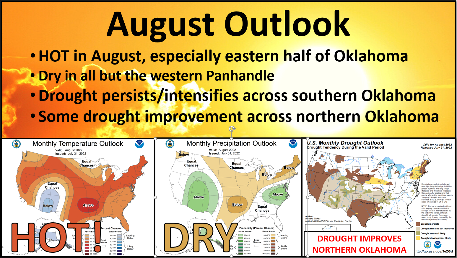
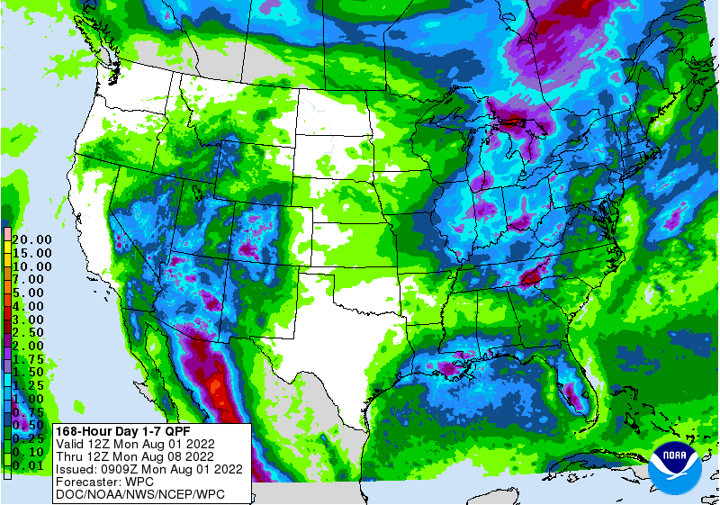
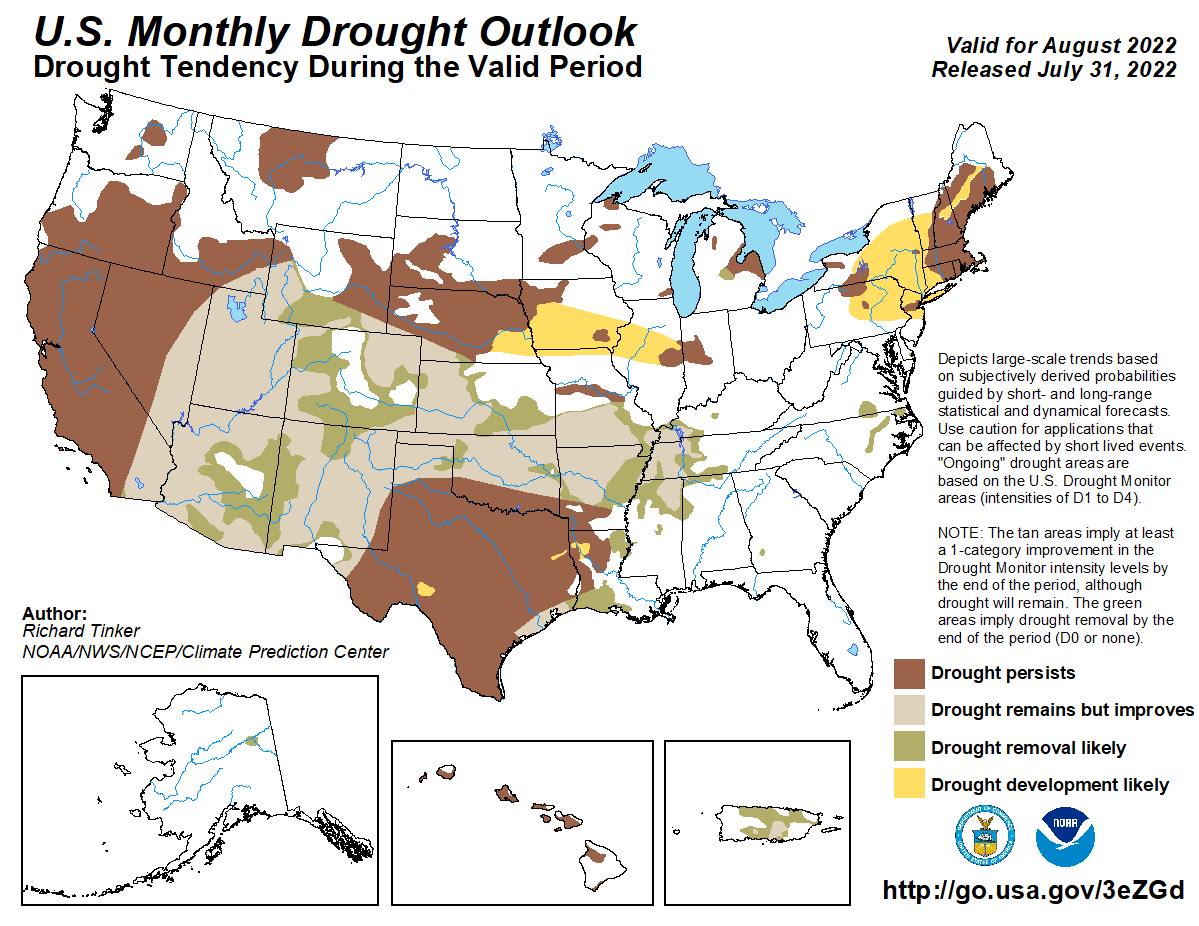
Yeah, you only WISH you had my job at times like this, right? It's not all fun
and memes ya know. But I'm gonna take the little bit of good news in the above
graphic--the drought improvement across the northern two-thirds of the state--and
dial that back a bit. That's all based on the rainfall that we've had over the
last few days, and it looks like they pushed it a tad south to me? (I'm not
really asking a question, just thought I'd be nice).
So yeah, if you're in OKC or Weatherford or Stigler, don't get too excited about
that August drought outlook. If the other two outlooks come true, the drought
will only get worser there. Yeah, I know worser ain't a word, but given those
temp and precip outlooks, it's warranted! And it does look like August is just
going to be more of the same for the state. I have said time and time again that
we haven't seen this type of heat since 2012, and darned if the month didn't tie
2012 for the 7th warmest July on record. You can read all of that below in the
July summary...but here we go again.
And here's the deal...if we are hot and dry again in August, that drought
improvement that we see across northern OK could all come back again. There
isn't anything stopping a flash drought from occurring twice in the same summer.
Odds are that WON'T happen, but that's what my barber said about me losing my
hair a couple of decades ago. My scalp suffered exceptional drought after that.
Just sayin'!
Okay, enough about August, look back at July.
And weep.
----------------------------------------------------------------------------------
July Heat Punishes Oklahoma
Aug. 1, 2022
The seemingly impenetrable heat wave and dry spell that had punished Oklahoma
since early June continued through nearly all of July, giving Oklahoma the type
of scorching hot weather unseen in the state since the brutal summers of 2011
and 2012. A strong cold front snuck through the heat dome’s defenses near the
end of the month to bring some relief, but the damage was done. The combination
of hot weather, a lack of significant moisture, and relentless sunshine
combined to plunge Oklahoma into flash drought that had covered the entire
state by the end of July. Farm ponds evaporated, soils dried out and baked, and
vegetation of all types either went dormant or died, turning the state’s
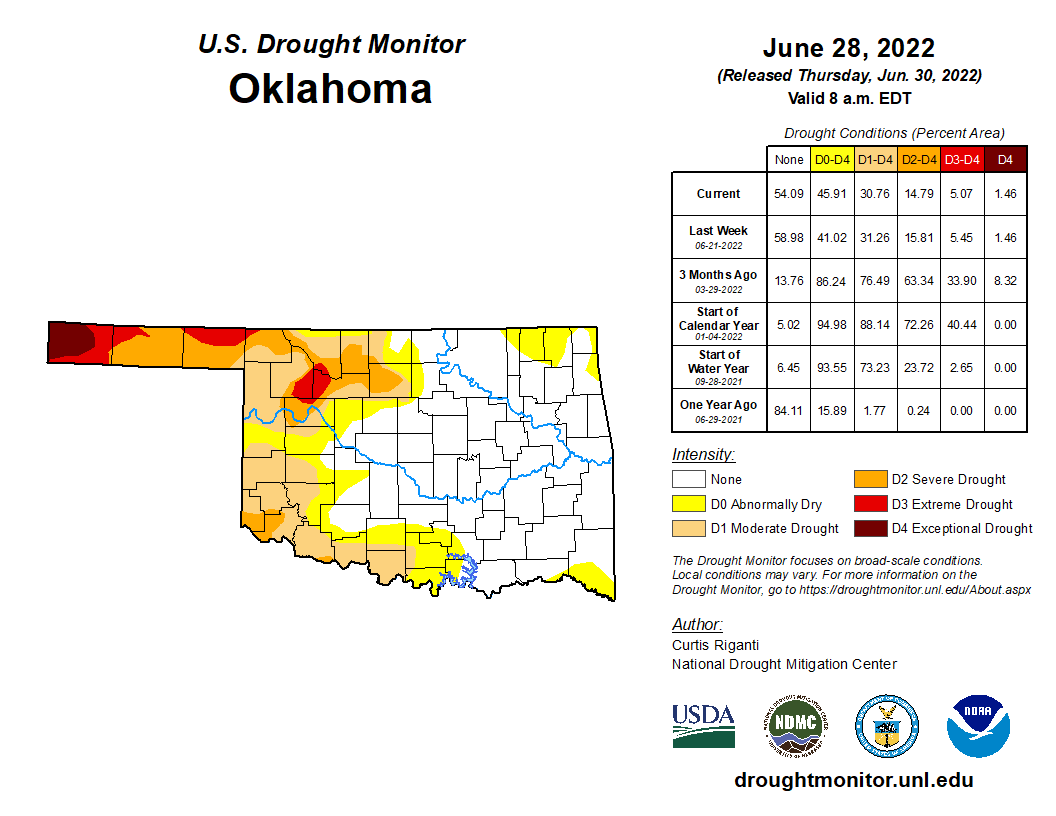
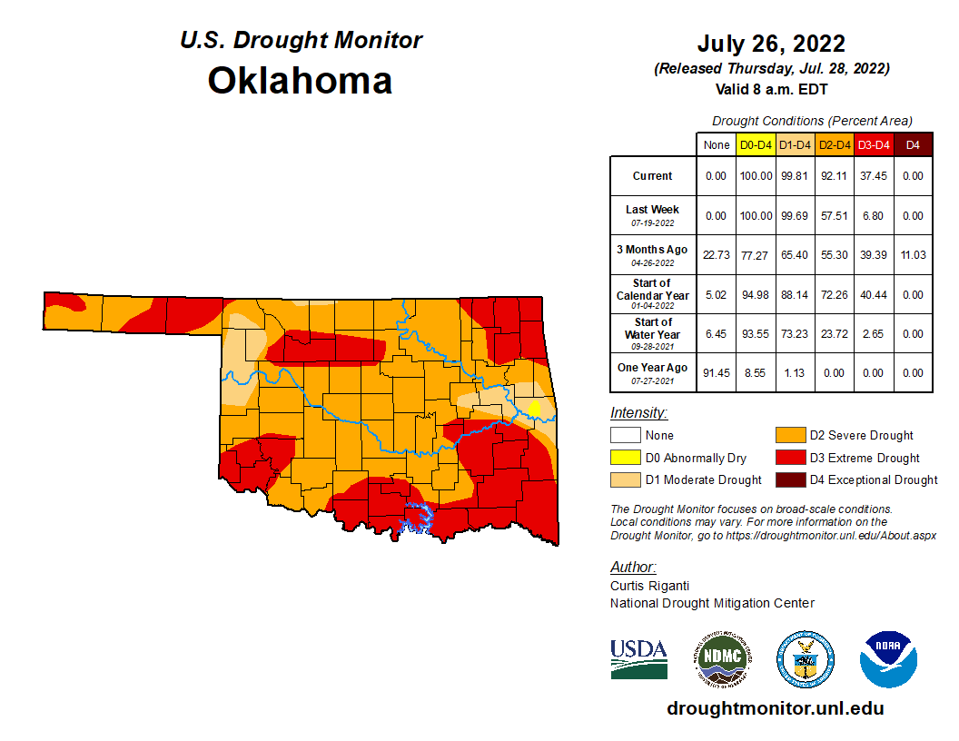
landscapes a sickly shade of yellow. Drought covered 31 percent of the state at
the end of June according to the U.S. Drought Monitor, but coverage skyrocketed
to 100 percent by the end of July. Wildfires increasingly became a problem as
the arid weather persisted. One large fire northeast of Mooreland consumed more
than 21,000 acres. Significant severe weather was largely absent during the
month, although an EF-1 tornado managed to touch down near Broken Arrow that
damaged homes and trees. That report brought the number of tornadoes during
2022 up to 41 according to preliminary data from the National Weather Service.
The 1950-2021 average through July is 49.5, and the annual average is 57.2.
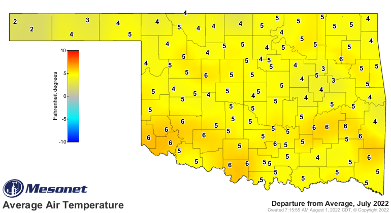
The statewide average temperature finished at 85.9 degrees according to
preliminary date from the Oklahoma Mesonet, 4 degrees above normal and tying
both 1998 and 2012 for the seventh warmest July on record. That mark remained
far behind July 2011’s 89.2 degrees, which still stood as the warmest month of
any month, any year, and any state since records began in 1895. This July’s
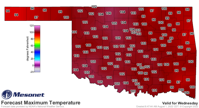
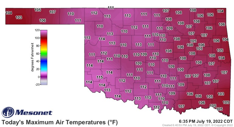
temperature topped out at 115 degrees at Mangum on July 19, tying the Mesonet’s
all-time highest reading with six other sites since it’s inception in 1997.
Oklahoma had not seen a temperature that high since Kingfisher hit 115 back on
Aug. 1, 2012. Oklahoma’s all-time highest recorded temperature of 120 degrees
was set at three separate locations in 1936, including twice at Altus. The 19th
was also the third time in Mesonet history that all 120 sites reached at least
100 degrees, sharing that honor with July 9 and 10, 2011. However, it was the
first time all sites reached at least 103 degrees. Mesonet sites recorded
temperatures of at least 110 degrees 72 times during July, and at least 105
degrees 594 times. The heat index soared even higher, hitting 119 degrees at
Eufaula on July 8, and 118 degrees at Burneyville on July 20. The Mesonet
observed heat index values of at least 110 degrees 383 times during the month.
Lake Carl Blackwell had the month's lowest reading at 58 degrees on the 19th.
The first two months of summer stand as the 10th warmest on record, 3 degrees
above normal, and the first seven months of the year came in as the 26th
warmest, 0.6 degrees above normal.

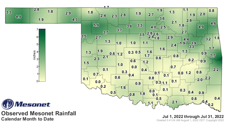
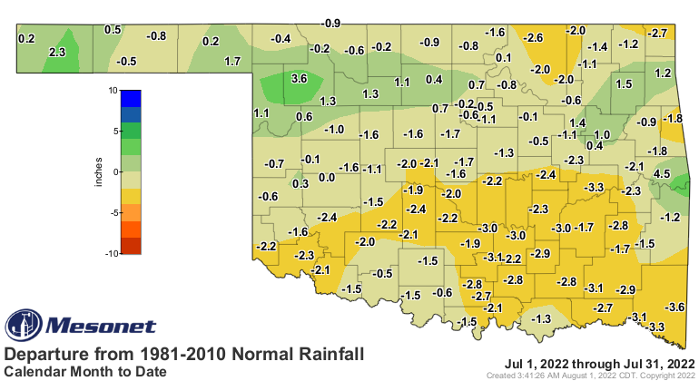
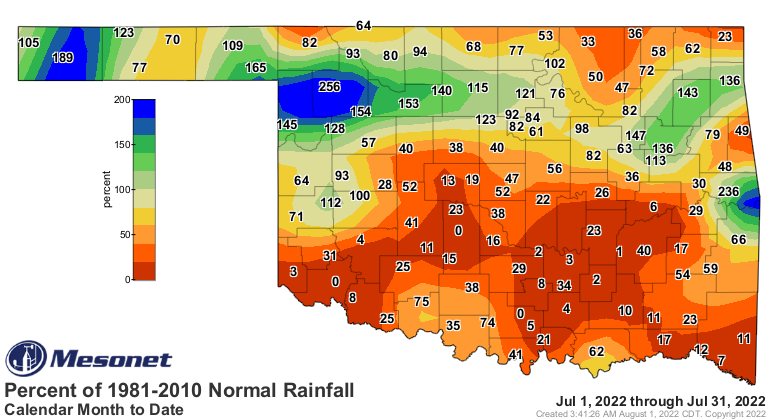
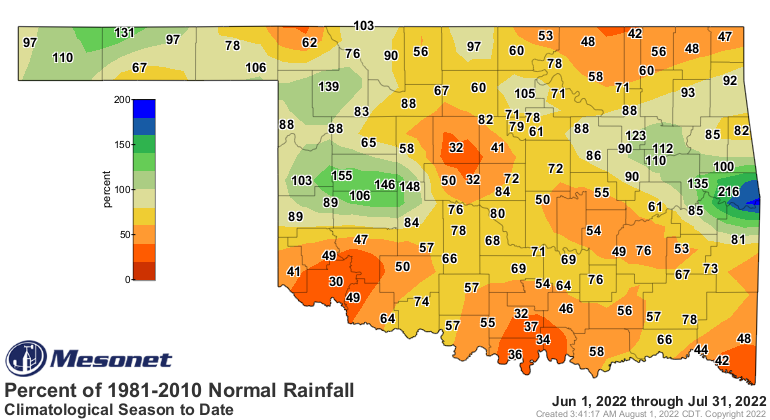
The statewide average rainfall total ended at 1.79 inches for the month, 1.41
inches below normal and ranked as the 32nd driest July on record. The disparity
in rainfall between northern and southern Oklahoma was striking, however.
Southwestern, south central, and southeastern Oklahoma suffered through their
14th, 14th, and 8th driest Julys on record, respectively, while the Panhandle
enjoyed its 42nd wettest. Totals ranged from 7.73 inches at Sallisaw to zero at
Altus. In addition to Altus’ goose egg, nine other sites recorded less than a
tenth of an inch of rainfall. Nineteen received at least 3 inches for the month.
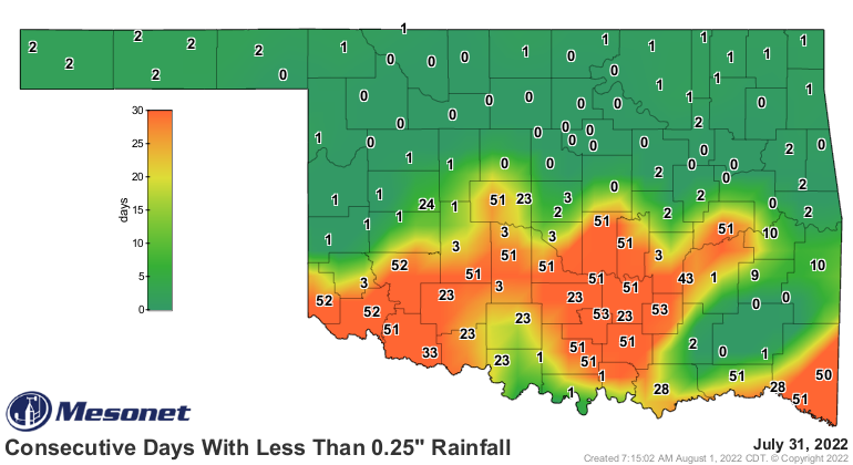
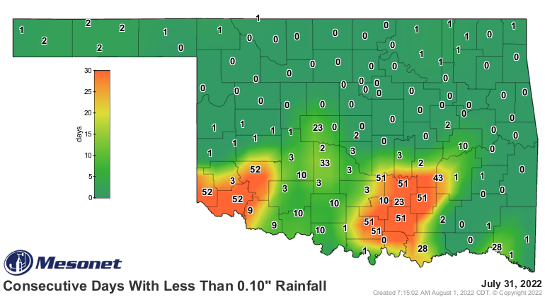
At the end of July, 20 Mesonet sites had failed to receive at least a quarter-
inch of daily rainfall for more than 50 consecutive days, and nine had not
received at least a tenth of an inch for the same span. The first seven months
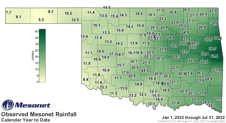
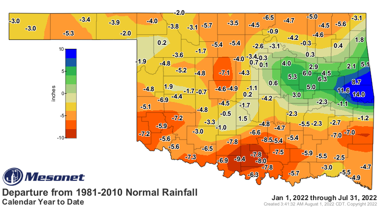
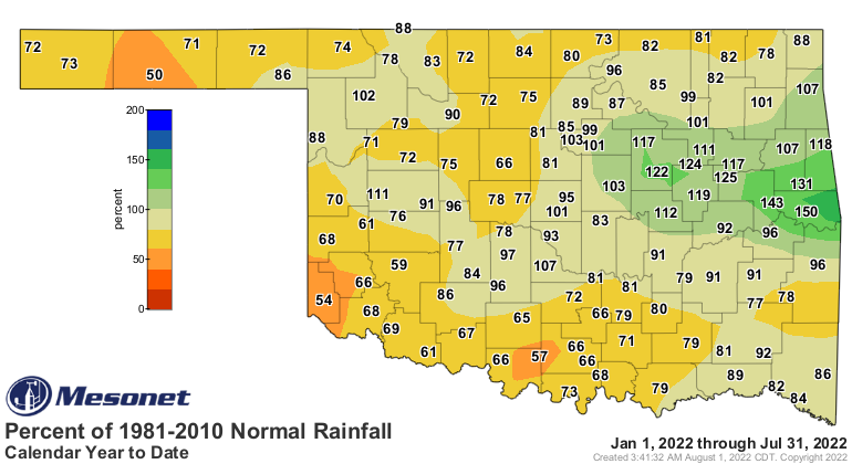
of the year ended as the 51st driest on record at 19.45 inches, 2.57 inches
below normal.
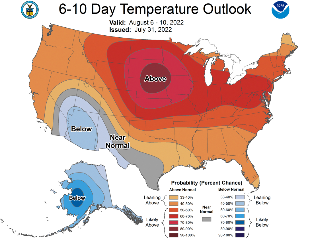
The same hot and dry conditions that dominated most of June and July are
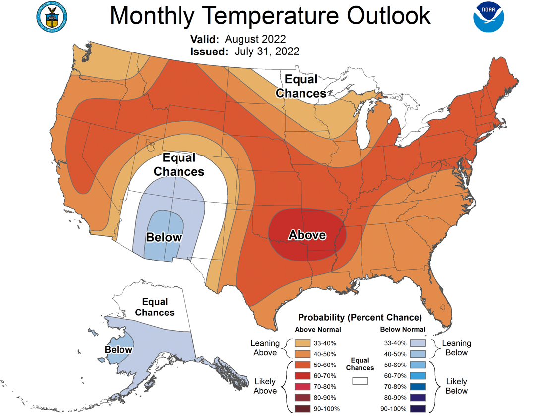
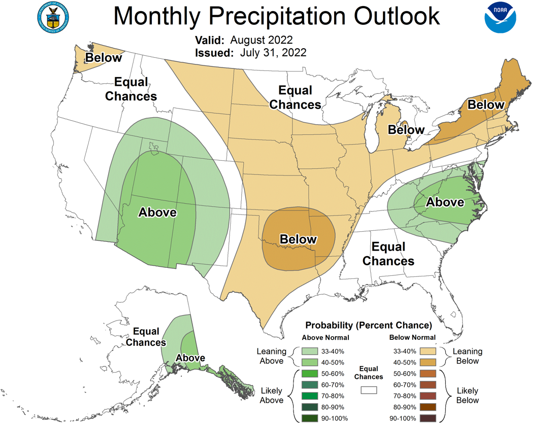
expected to prevail once again in August. The August outlooks from the
Climate Prediction Center call for increased odds of above normal temperatures
across the entire state and below normal precipitation in all but the western
Panhandle. CPC’s August drought outlook predicts drought persistence across the
southern one-third of Oklahoma, but improvement across the northern two-thirds.
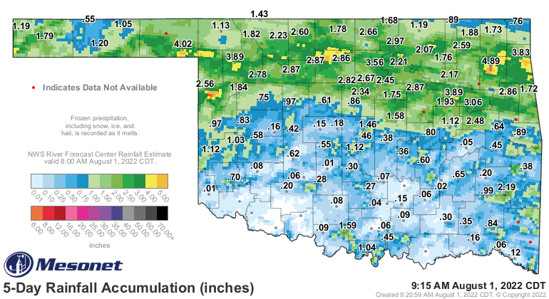
However, much of that improvement is based on the heavier rains that fell in
late July.
Gary McManus
State Climatologist
Oklahoma Mesonet
Oklahoma Climatological Survey
gmcmanus@mesonet.org
August 1 in Mesonet History
| Record | Value | Station | Year |
|---|---|---|---|
| Maximum Temperature | 115°F | KIN2 | 2012 |
| Minimum Temperature | 53°F | KENT | 2018 |
| Maximum Rainfall | 5.04 inches | NOWA | 1995 |
Mesonet records begin in 1994.
Search by Date
If you're a bit off, don't worry, because just like horseshoes, “almost” counts on the Ticker website!