Ticker for April 22, 2022
MESONET TICKER ... MESONET TICKER ... MESONET TICKER ... MESONET TICKER ...
April 22, 2022 April 22, 2022 April 22, 2022 April 22, 2022
Just stop
Yeah, that's the NICE meme I made. The "get Gary fired" meme had Samuel L. Jackson
and a certain quote from a movie about snakes. I don't know that I've ever been
more ready for a big pattern change lately except for maybe February 2021, and
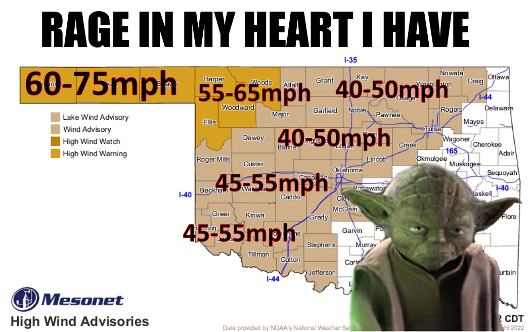
of course throughout the latest drought. But come on, this wind is crazy stupid,
even for Mother Nature's previous Oklahoma work. I know that March and April are
windy months in Oklahoma...it's sort of in my job title. But this is getting
ridiculous. There have been prolonged windy periods in the state before, of course.
It's Oklahoma. The problem here is the much above average wind speeds are
occurring at the windiest time of the year. So it's an "extreme extreme." Think
unusually hot in July (2011), or unusually cold in February (2021).
Check out this graph of long-term statewide average maximum wind speeds for 2007-
2021 (black), 2022 (red), 2011 (green), and 2009 (burnt sienna...or mahogany if
you were like me growing up and couldn't afford the 64 pack of crayons). Only
2009 seems to rival what we're experiencing at this point in the year, although
2011 comes close as well.
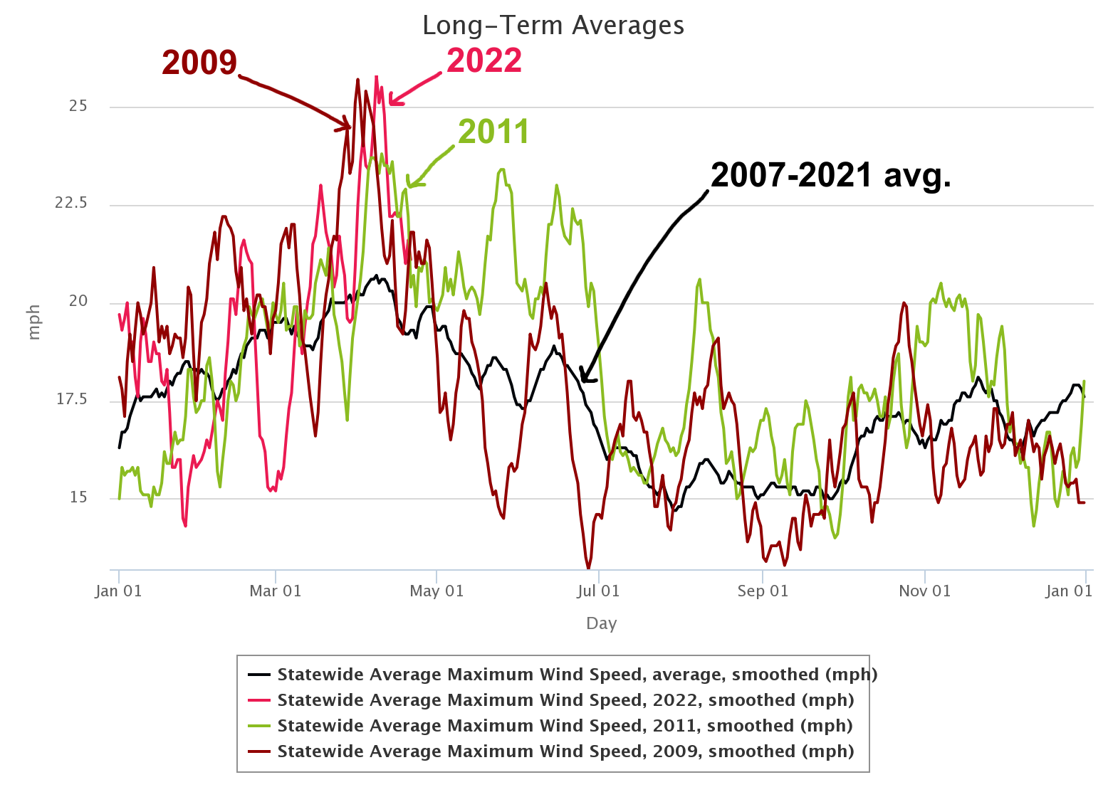
I can't really remember why it was so windy back in spring 2009 (which is
weird, it's sort of in my job title), except for the big blizzard up in NW
OK in late March that dropped 26 inches of snow in Freedom and Woodward. Their
winds, well...I guess OUR winds, dropped off after that, with the usual
spikes up and down. Now 2011 is another story. I remember quite well what was
going on in spring and summer of 2011. Lots of dry fronts and bigtime drylines
with blowing dust across western OK and lots of storminess and 50 tornadoes
during April to the east of those drylines...every single one of them to the
east of I35, as a matter of fact. Bigtime drought, bigtime heat, and bigtime
storms...then it got worse during the summer, those strong southwesterly winds
propelling us to the hottest summer for any state for any year on record, as
well as the hottest month (July) of any state for any year on record.
So theoretically, our winds should start to die down if you look at the
long-term average curve on the graph, but not always. And theoretically, if
we follow 2011's path, I will definitely be breaking out that Samuel L. Jackson
meme.
Now on to other bidness. You thought I was going to use "onto" but I threw a
curveball and went with "on to." I'm that angry.
We have a chance for some storms today across the beleagured...uhhh, beleaguered,
Panhandle. You want to hear something crazy? Other than everything typed above?
If they do get big storms, the winds might actually be LOWER at times with
those severe storms than just their regular gusts today. Let that sink in!
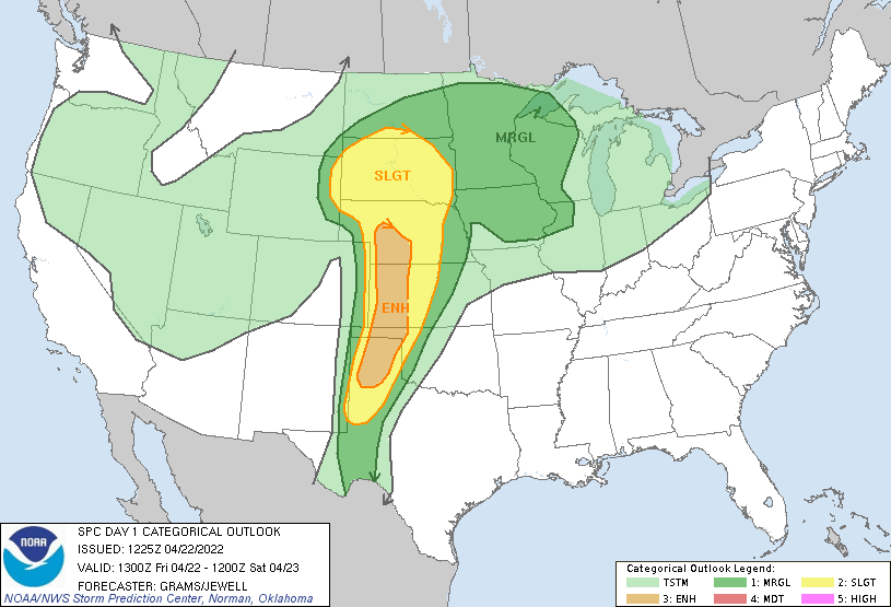
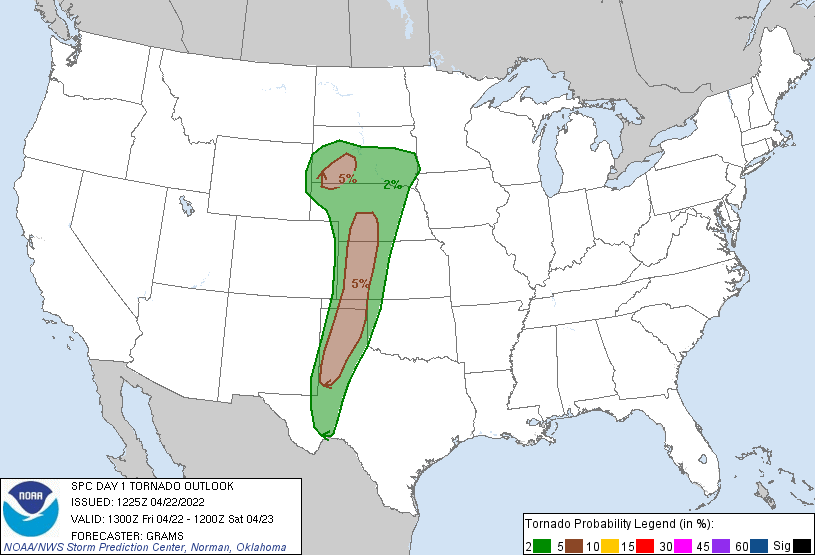
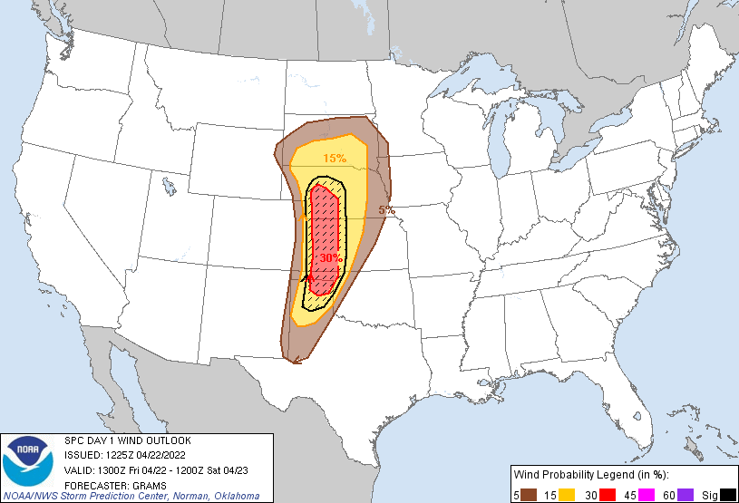
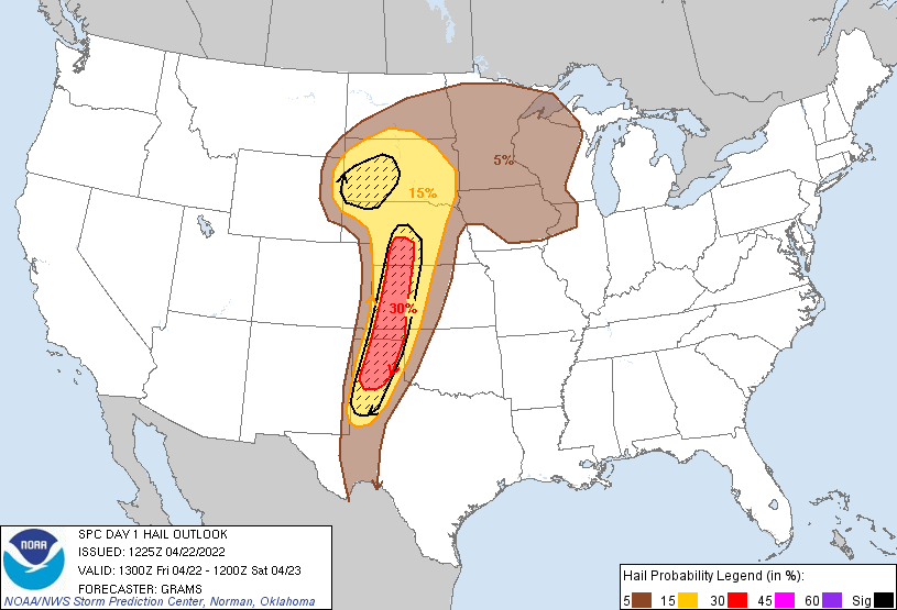
Big hail is a particular threat, which could damage the little wheat that made
it through the drought. There is a chance of tornadoes (ain't there always),
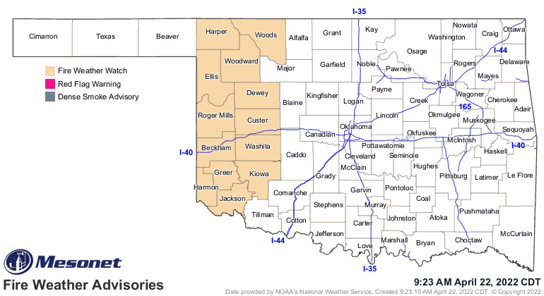
but a low chance mostly. Of course there's fire danger over the next two days.
What else would we expect? Tomorrow in particular.
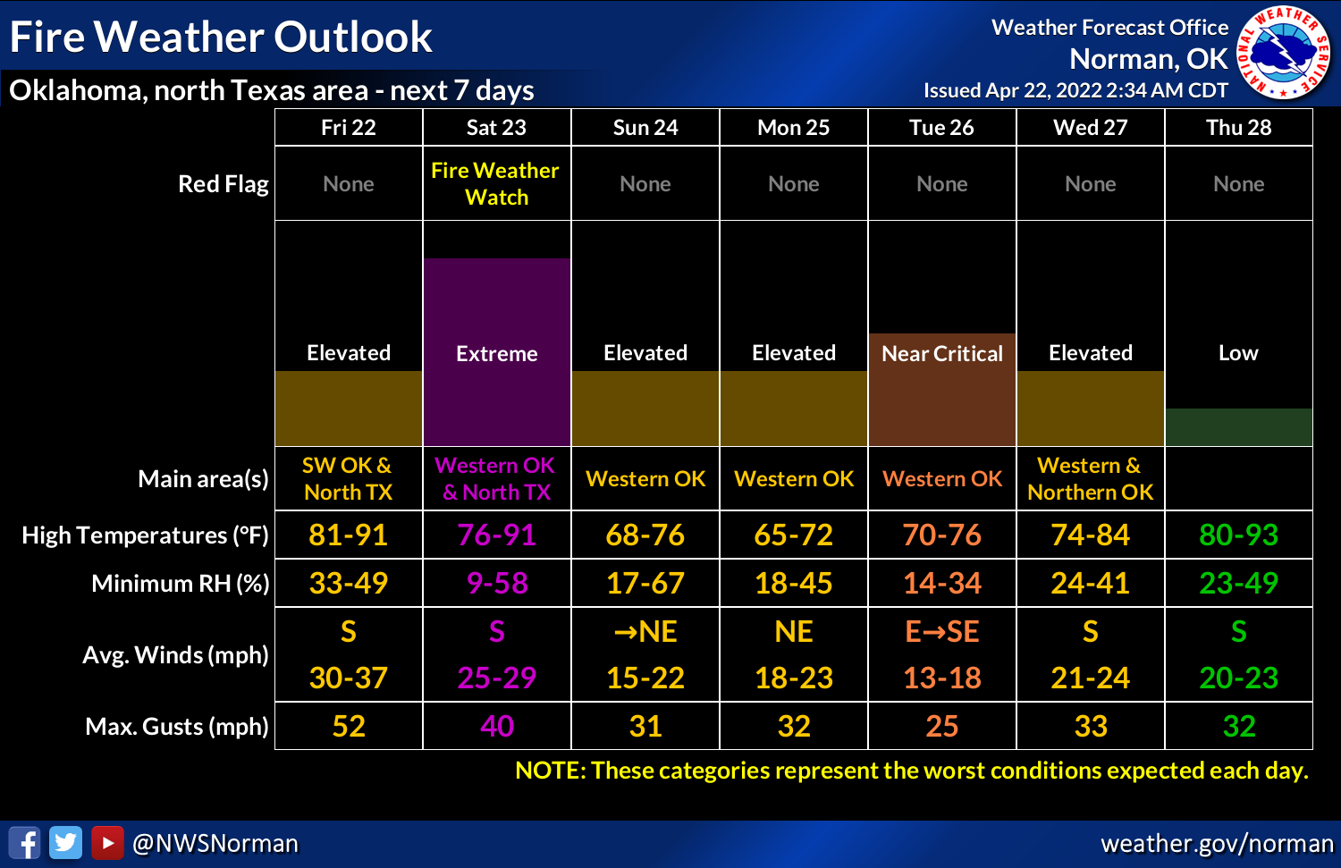
Another chance for storms tomorrow, but the bigtime rains have shifted more
to the southeast. There is hope for some rain with the storms in the Panhandle,
at least. Somebody's gonna get left out, though.

Okay, I've vented enough. I'll just leave you with this...make your own meme.

Gary McManus
State Climatologist
Oklahoma Mesonet
Oklahoma Climatological Survey
gmcmanus@mesonet.org
April 22 in Mesonet History
| Record | Value | Station | Year |
|---|---|---|---|
| Maximum Temperature | 98°F | WALT | 2011 |
| Minimum Temperature | 25°F | EVAX | 2021 |
| Maximum Rainfall | 6.48 inches | MCAL | 1996 |
Mesonet records begin in 1994.
Search by Date
If you're a bit off, don't worry, because just like horseshoes, “almost” counts on the Ticker website!