Ticker for March 1, 2022
MESONET TICKER ... MESONET TICKER ... MESONET TICKER ... MESONET TICKER ...
March 1, 2022 March 1, 2022 March 1, 2022 March 1, 2022
March on
Yeah, that's weird. No, not my reflection...okay, maybe so, but I'm talking
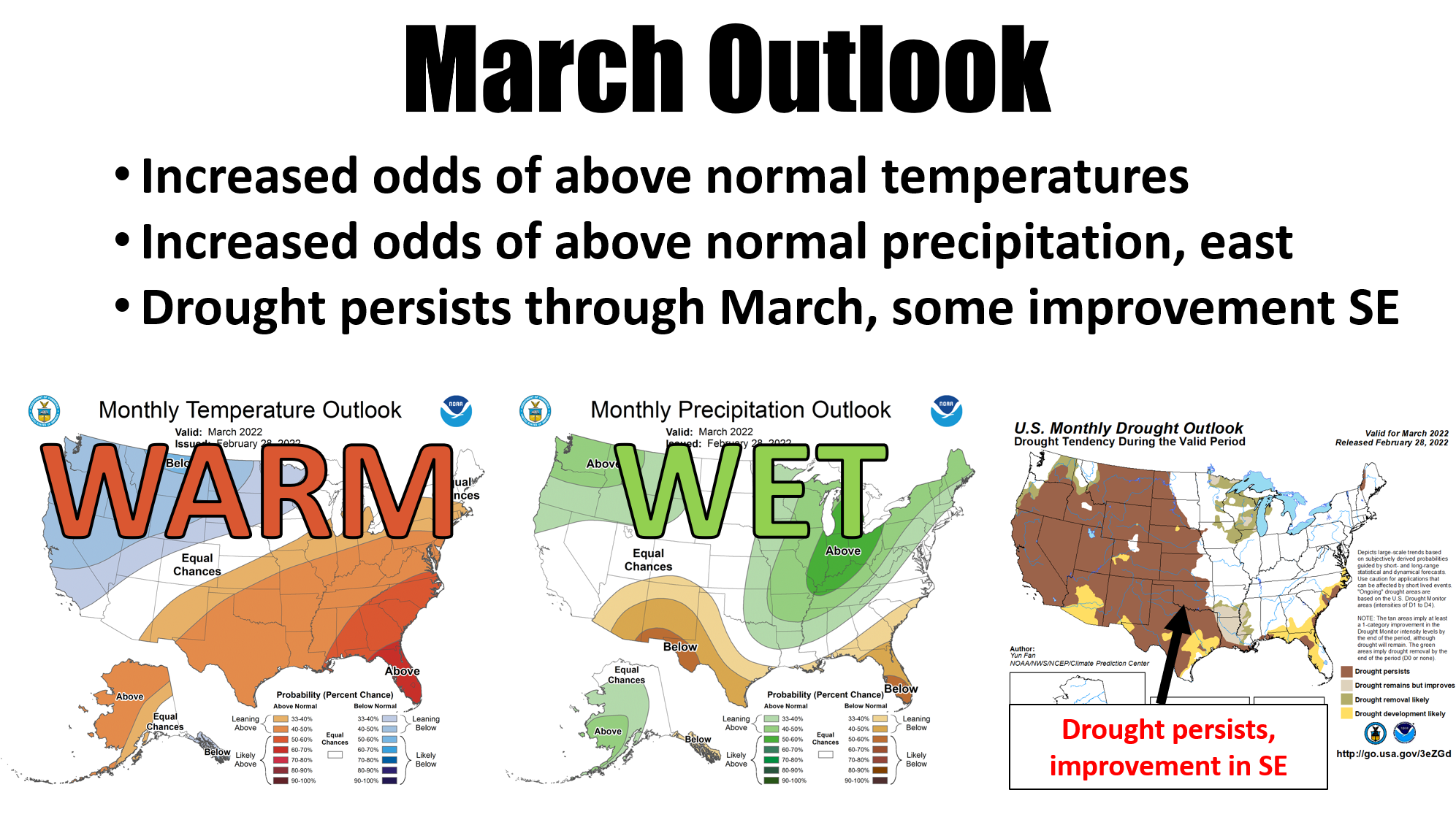
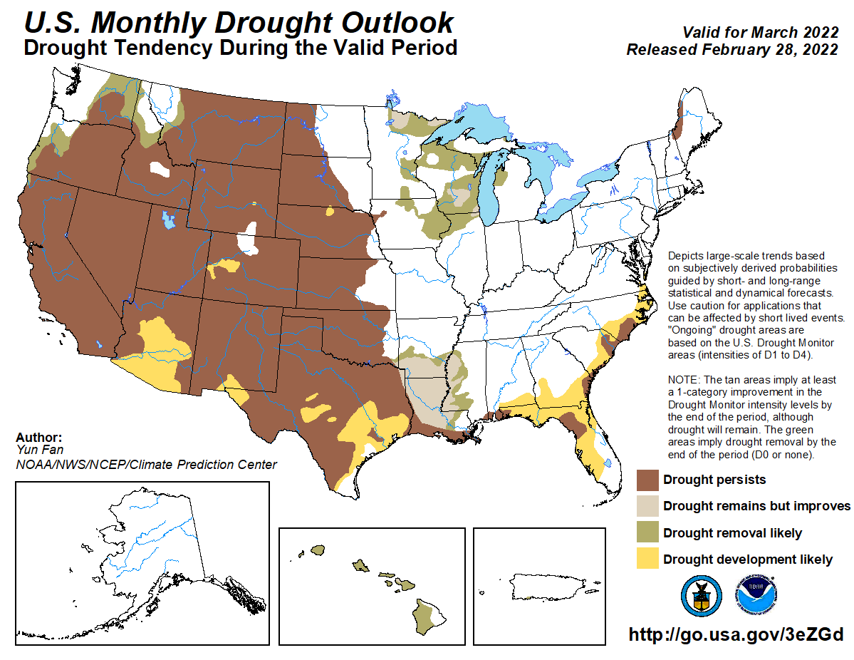
about the March precip outlook showing increased odds of above normal
precipitation across eastern OK, but mostly drought persistence on the drought
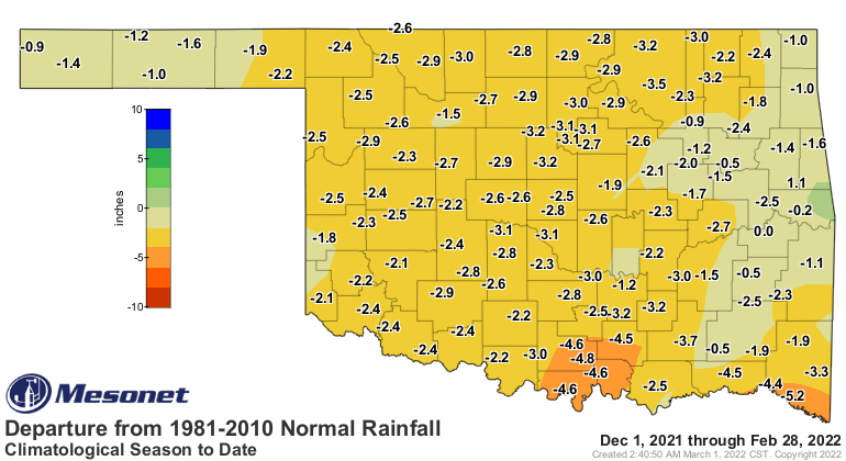
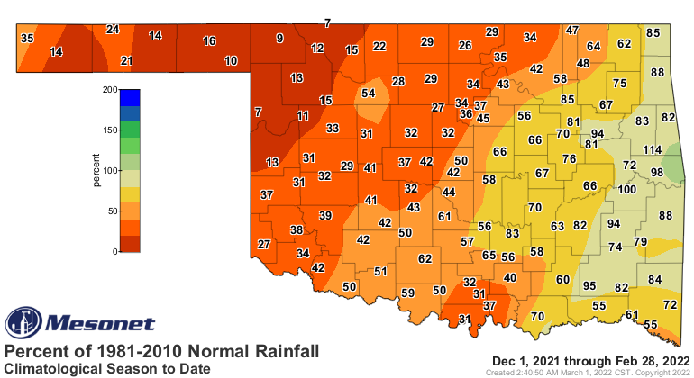
outlook. Deficits are still significant over parts of eastern OK (see the
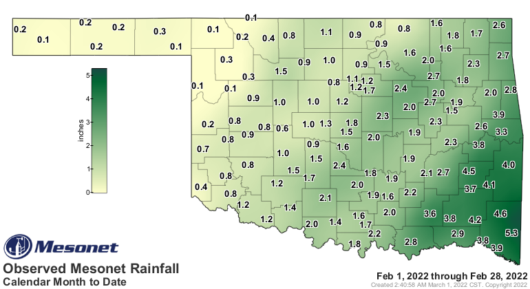
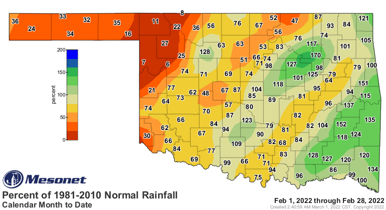
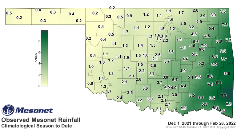
February summary below for monthly and seasonal rainfall maps), so given that
March is still a dry month for Oklahoma, perhaps "wetter than normal" isn't
enough to warrant improvements.
Why worry so far ahead, though? We have weather this week. Our lovely spring
weather through Saturday, then another cooldown for the weekend with another
storm system. Don't worry, doesn't look like widespread snow and ice like
the last few storms, although there is still the possibility for the dreaded
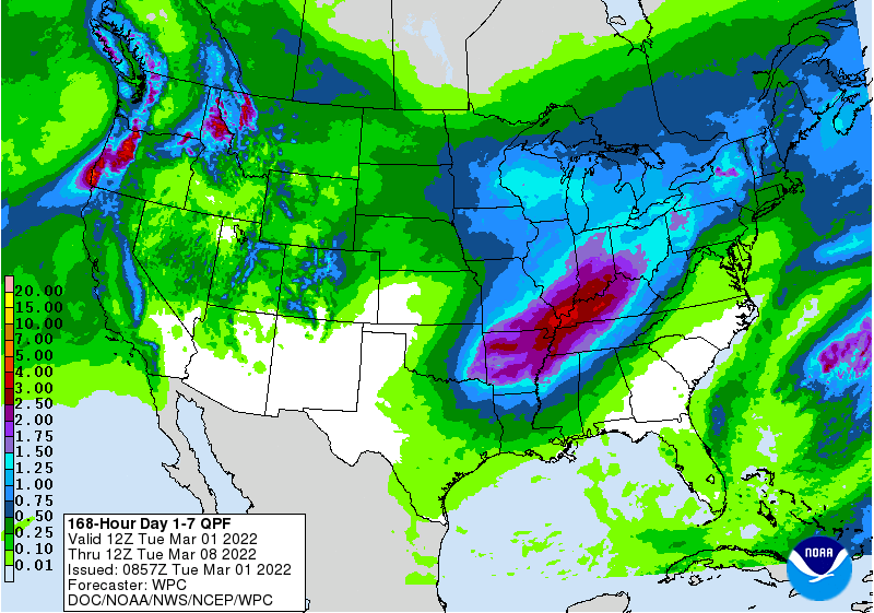
"winter mix" across northern OK. More importantly, there should be some moisture
with the storm. Don't get too cocky after those February systems...wasn't too
long ago (August-December) that nearly all our fronts were dry. I'll ignore a
chance for some bathroom humor there and just post the 7-day precip forecast
map.
IF YOU'RE BACKSIDE IS WET YOU SHOULD GET SOME BETTER TOILET PAPER!
Dang it, just couldn't contain it. (Chance #2 for toilet humor...not gonna do it).
We were told (okay, *I* told you, but it was more sarcasm than anything)
yesterday that winter was over. Well, not so fast.
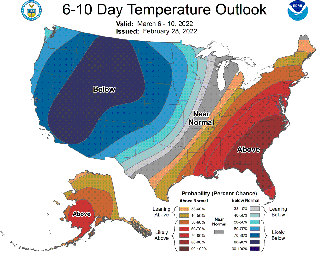
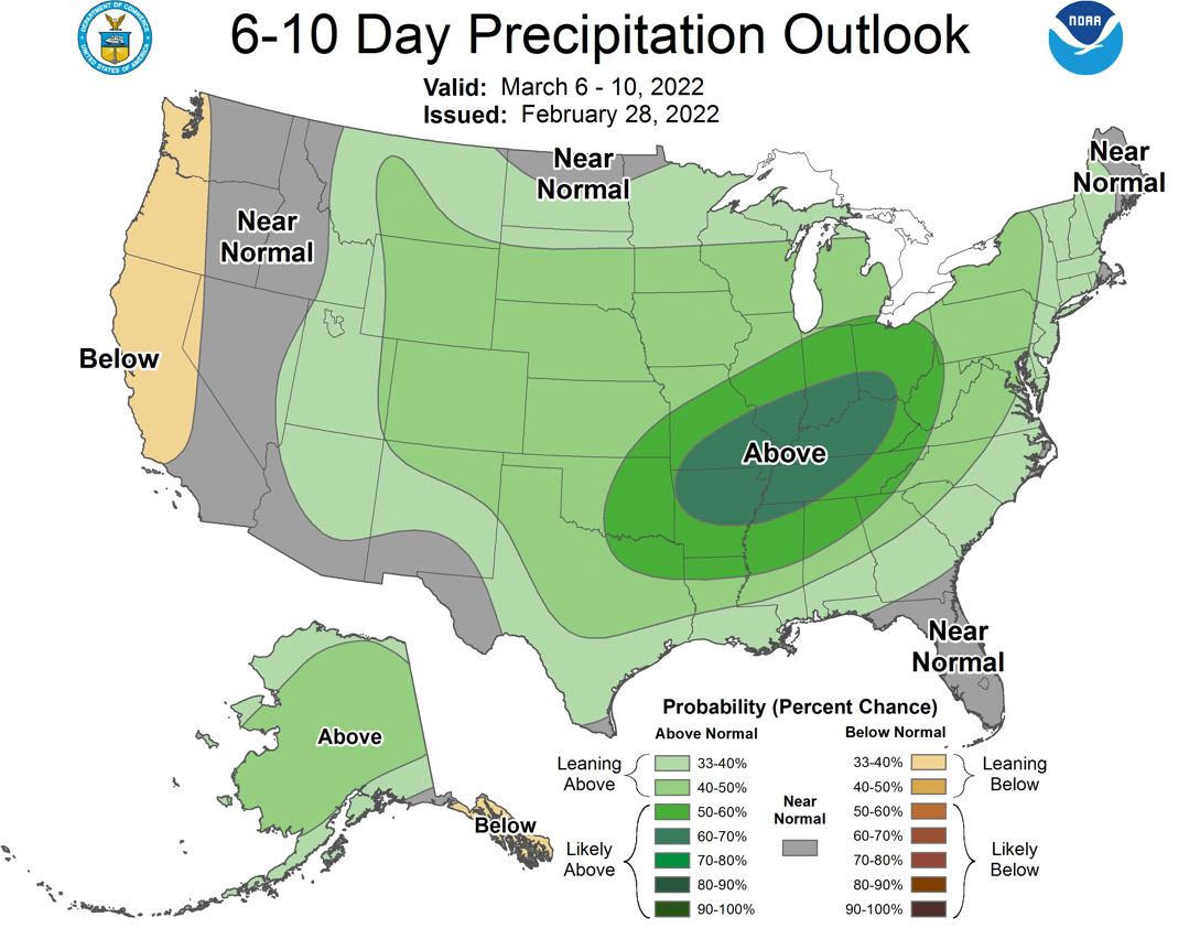
Yeah, that looks sort of ominous, but maybe not so much. For one thing, it's
March so below normal temperatures don't necessarily translate to below
freezing, at least for long stretches. And B, it's all in the timing anyway.
That's a 5-day period, so any attempt to time up the precip and any cold air
won't necessarily work.
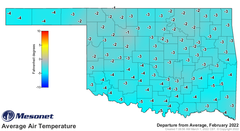
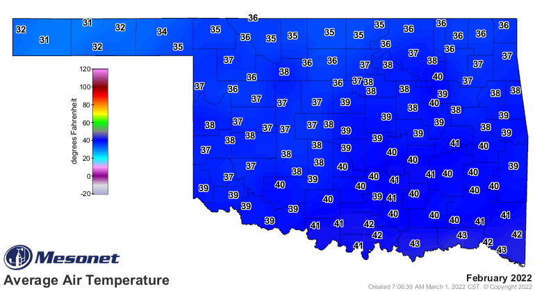
Speaking of funny, check out February's temperatures.
HAHAHAHAHAHAHA!!
HAHAHA!
HAHA
haha
ha
Well, I think it's funny. We know February was colder than normal (see below
for stats), but it's a bit odd that most of that was on the minimum temperature
side. High temperatures seemed fine most of the time. Check out the departure
maps from the Mesonet.
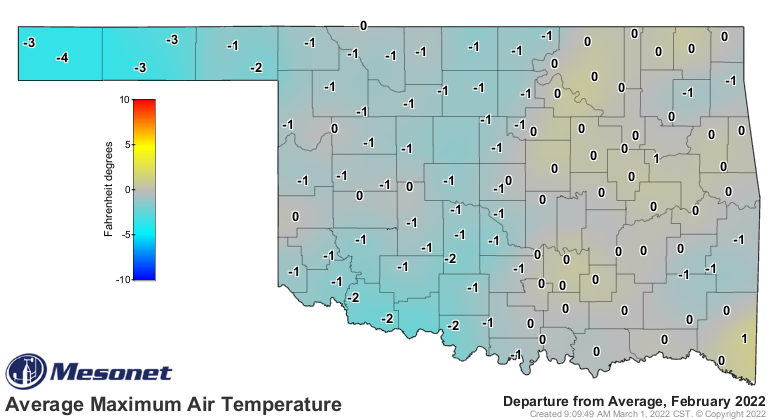
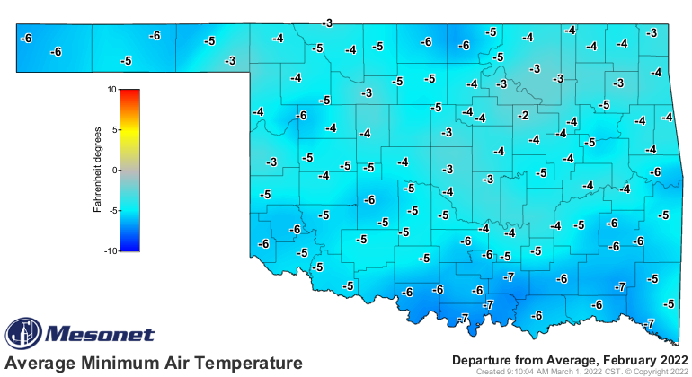
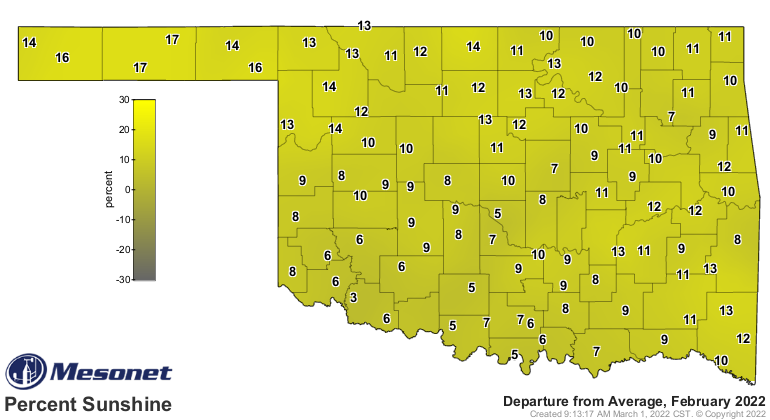
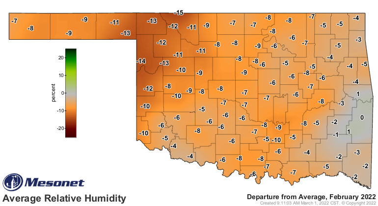
That smells of possibly a Relative Humidity thing. So the drier air warms quite
readily under all those sunny skies, but at night much of that heat radiates
out and escapes under those dry clear skies? Sounds plausible to me.
Of course, toilet paper gloves seemed plausible to me, too. They aren't.
I knew there was another one in there! Okay, read on for more about February's
exciting wintry weather.
----------------------------------------------------------------------------------
Wintry Weather Rules February
March 1, 2022
Three impactful winter storms struck Oklahoma during February, snarling traffic
on state highways, bringing down power lines, and forcing widespread closures
of businesses and schools. The first storm struck Feb. 1-3 and dumped 4-6
inches of snow over a significant portion of the state. Larger totals were
scattered about, with nearly a foot of snow reported in both Hooker and
Seminole. That same system covered parts of southeastern Oklahoma with up to a
half-inch of freezing rain, damaging trees and power infrastructure in the area.
The second storm produced near blizzard conditions across far northern Oklahoma
on Feb. 16-17. Another swath of 4-6 inches was observed across those counties,
with a volunteer observer at Helena in Alfalfa County reporting 8 inches. Winds
gusting to over 40 mph produced snow drifts in that area of more than 5 feet.
The third storm dumped 1-2 inches of sleet across the southeastern half of
Oklahoma on Feb. 23-24, encasing a significant portion of the state in an icy
shell that would take days to melt. Thunder was heard during the sleet,
signaling enhanced convective precipitation rates. Much of the state received
6-8 inches of snow for the month. Helena led all totals at 17 inches with
Seminole in second at 12 inches. Severe weather was nearly nonexistent for the
month, but wildfires were a consistent hazard throughout February.
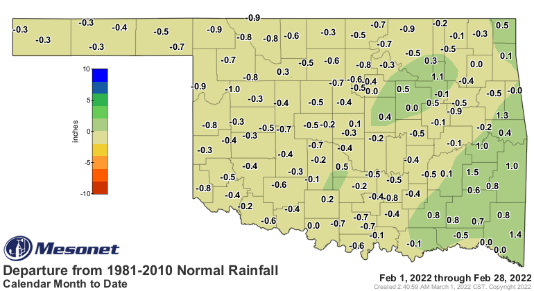
According to preliminary data from the Oklahoma Mesonet, the statewide average
precipitation total was 1.6 inches, 0.09 inches below normal and ranked as the
54th wettest February since records began in 1895. Totals for the month ranged
from 5.29 inches at Broken Bow to a meager 0.06 inches at Camargo. Forty-one of
the Mesonet’s 120 sites ended up with an inch or less for the month, while 28
sites managed at least 2 inches. Even with February’s modest moisture totals,
the climatological winter—December through January—ended as the 23rd driest on
record at 3.08 inches, 2.29 inches below normal. Winter totals ranged from 9.84
inches at the Mesonet site at Mt. Herman in McCurtain County to 0.18 inches at
the May Ranch site in far northern Woods County.
February ranked as the 38th coolest on record with a statewide average of 38.6
degrees, 3.8 degrees below normal. There was still plenty of pleasant weather
in between the bouts of winter chill. Highs often rose into the 60s and 70s in
advance of each winter storm system, culminating with a high of 82 degrees at
Altus, Hollis, and Tipton on the 16th and again at Mangum on the 21st. Cold
weather still dominated the month, however. Kenton dropped to minus 12 degrees
on the 4th, and temperatures fell below zero a total of 20 times across the
Mesonet’s 120 sites during February, nearly all in the Panhandle region. The
Mesonet recorded 243 wind chills of minus 5 degrees or less throughout the
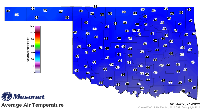
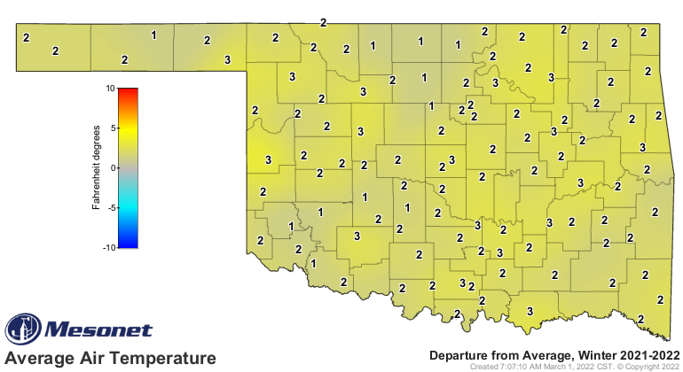
month, topped by Hooker’s -27 degrees on Feb. 4. Buoyed by December 2021’s
remarkable warmth, the climatological winter finished 2.6 degrees above normal
to rank as the 16th warmest December through February on record with a
statewide average temperature of 42.1 degrees.

The February moisture provided significant drought relief across far eastern
Oklahoma, but merely staved off intensification in the western half of the
state. Drought coverage decreased from 88.2% at the end of January to 86.7% at
the end of February according to the U.S. Drought Monitor. The Climate
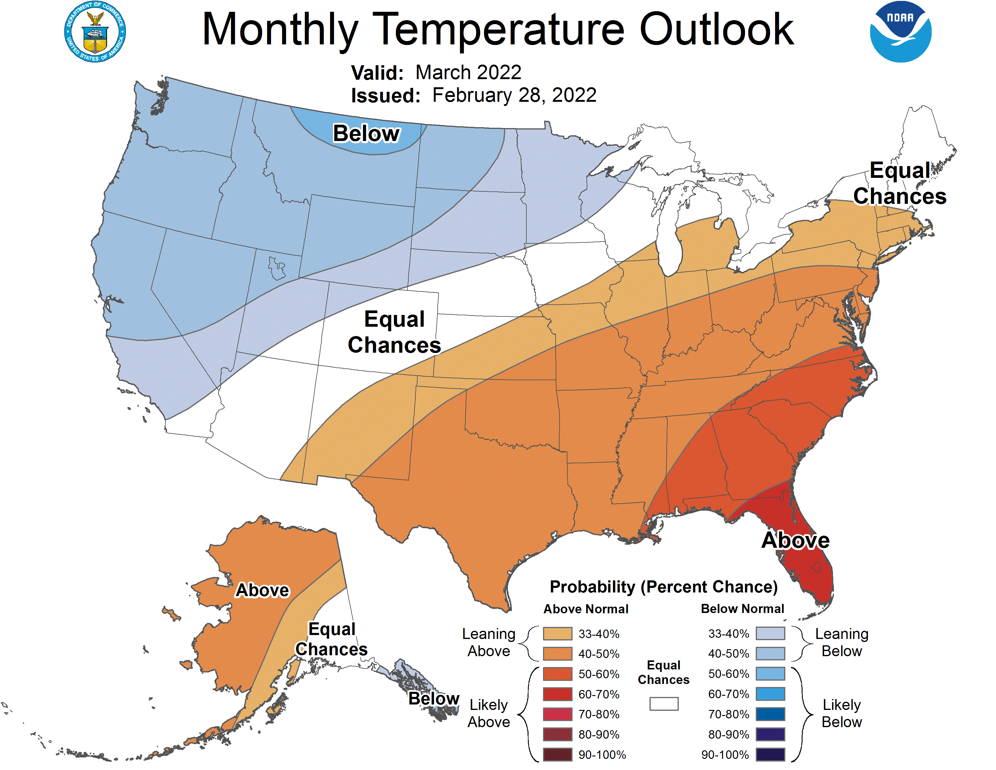
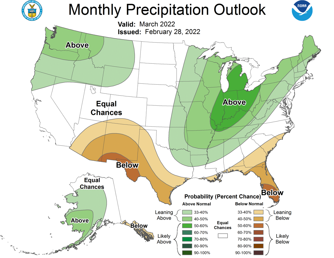
Prediction Center’s March outlooks for temperature and precipitation paint a
picture of a warm month ahead for the entire state, and wet as well for eastern
Oklahoma. All of Oklahoma has increased odds of above normal temperatures for
March, with the eastern half of the state seeing those same increased odds for
above normal precipitation. CPC’s March drought outlook calls for improvements
across far southeastern Oklahoma, but to persist elsewhere through the month.
Gary McManus
State Climatologist
Oklahoma Mesonet
Oklahoma Climatological Survey
gmcmanus@mesonet.org
March 1 in Mesonet History
| Record | Value | Station | Year |
|---|---|---|---|
| Maximum Temperature | 95°F | NEWP | 2006 |
| Minimum Temperature | 7°F | GOOD | 2001 |
| Maximum Rainfall | 1.86 inches | HUGO | 1997 |
Mesonet records begin in 1994.
Search by Date
If you're a bit off, don't worry, because just like horseshoes, “almost” counts on the Ticker website!