Ticker for August 19, 2021
MESONET TICKER ... MESONET TICKER ... MESONET TICKER ... MESONET TICKER ...
August 19, 2021 August 19, 2021 August 19, 2021 August 19, 2021
Fall Fail?
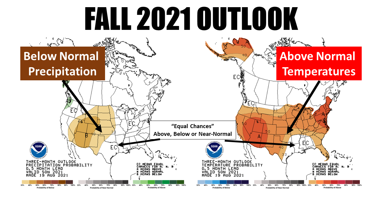
Well the annual autumnal augury (English to Okie translation: "What it's fixin'
to do") is out from the Climate Prediction Center and the word for fall is "hair
transplant." Okay, that's two words...how about "warm and dry?" If the outlooks
hold true, that's the way we're headed. And while I'm just doing a shallow dive
into the science here, just remember that this is just an indication that the
odds are SLIGHTLY tilted into the favor of the northwestern half of the state
ending up on the dry side over that 3-month period when it's over, and most of
the state (save for the far southeast) finishing warmer than normal. It doesn't
take into account any extreme events (February 2021, we're looking at you) that
might pop up. The southeast gets into the "Equal Chances" territory, meaning
the above-, below- and near-normal odds are about equally favored for both
temps and precip. The odds for above normal temperatures are a little greater
over the western half or so of the state, somewhere above 40% for that outcome.
Now given those outlooks for temp and precip, we get this for the drought outlook
through November 30. It ain't pretty for the hard hit areas across the West and
the North.
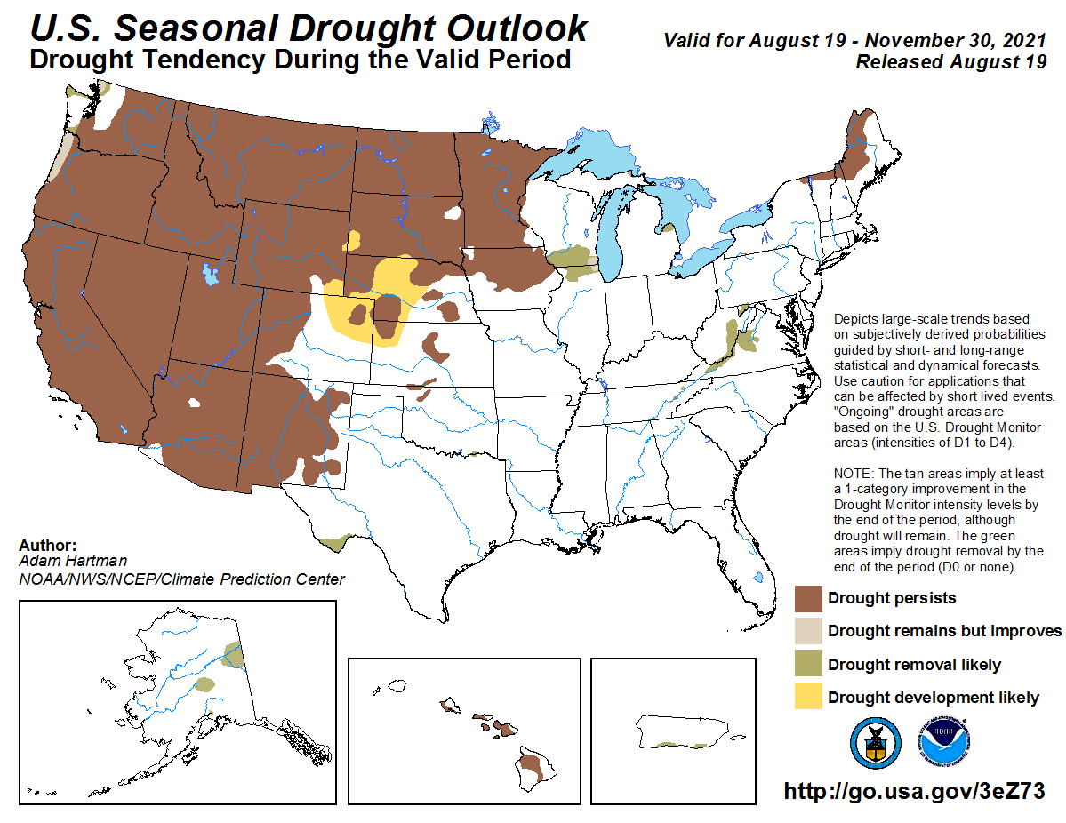
We also see out drought areas across NW OK are expected to persist and possibly
intensify, but we don't see any prognostications of spread further in the state.
But here's the deal...there is a LOT of drought surrounding us, and if we do
see above normal temps and below normal precip across the western half of the
state, I think we could see some further drought development. Here's what the
folks at CPC say for our region:
Drought continued to recede across the Southern Region in July, with
drought limited to small parts of western Texas and northern Oklahoma.
With odds favoring a wet August, drought is expected to be removed from
western Texas by the end of August, but an uncertain rainfall forecast
and enhanced chances for warmer than normal weather led to a
low-confidence forecast of drought persistence in northern Oklahoma.
The rest of the region should remain drought-free.
So their look for northern OK is not too strong. That doesn't really help too
much, but the data shows what it shows.
One of the expected culprits here is a double-dip La Nina event, which occurs
more often than not after a La Nina. CPC has a La Nina watch in place, signalling
the possibility of La Nina development over the next few months, which would
then probably last through the 2021-22 winter into early spring at least. Last
year's La Nina didn't ever really get revved up changing the atmospheric
circulation enough to give us the full suite of La Nina impacts, and of course
nothing could account for the February Deep Freeze extreme event. But we did see
greatly enhanced Atlantic tropical activity, which is already underway this year.
And the performance of a previous year's La Nina event doesn't really predict
the outcome of the double-dip occurrence. We really have to remember that a
particular phase of ENSO doesn't guarantee any of the usual impacts of La Nina
or El Nino, it just TILTS THE ODDS IN THEIR FAVOR because that is what has been
observed more often than not during previous events. And those impacts generally
point to a bit more dry, warm weather during the cool season in our area, but
more so to our south.
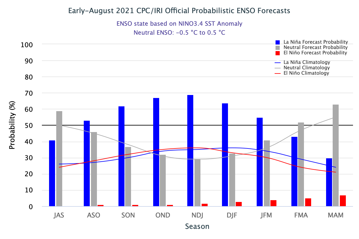
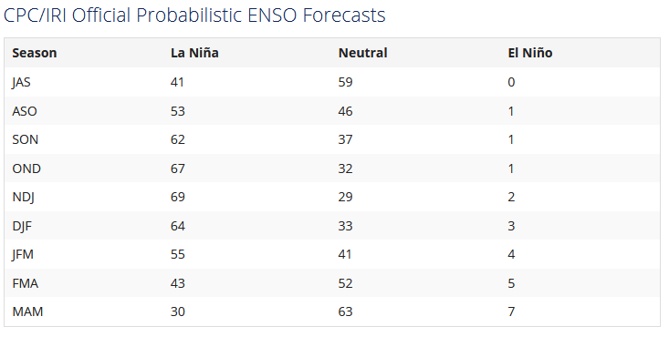
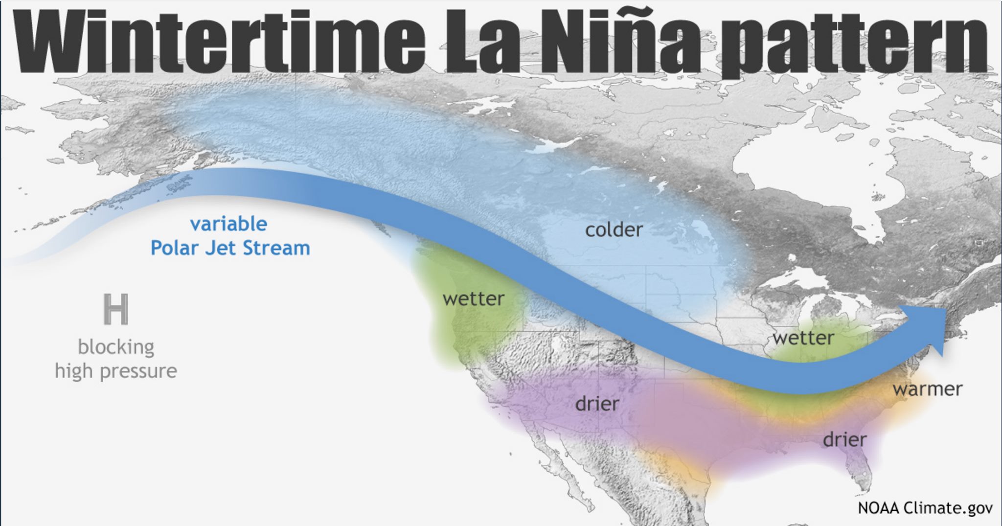
The strength of the event matters, of course. The guidance I've seen shows
a greater possibility of a weak La Nina, but we're still just a bit far
out for that just yet. Odds have gone up just a bit for a moderate event, and
are still quite low for a strong event. Here is a reminder of some possible
impacts (THESE ARE THINGS THAT HAVE OCCURRED MORE OFTEN THAN NOT DURING LA NINA
EVENTS):
-- Odds would be tilted towards a DRIER climate for the November-March period
across Oklahoma.
-- Snowfall could be diminished across northwestern Oklahoma.
-- Severe weather events could be more frequent across central and eastern
Oklahoma.
-- The remainder of the hurricane season (June 1-November 30) could see enhanced
activity across the Atlantic and reduced activity in the Pacific.
Now back to that "climate vs. weather" theme, please keep in mind that ENSO (El
Nino or La >Nina...or even Neutral Conditions) is only one factor, but as climate
factors go, it's one of the more easily predictable. Other factors that can
impact our winter climate and weather include the Arctic Oscillation and the
North Atlantic Oscillation, which can influence the number of arctic air masses
that penetrate deep into the U.S. and are very difficult to forecast more than
a week or two in advance.
We'll have more as we start to approach fall and get some better forecasts. And
before I hear any belly-achin' over last year's La Nina event, remember the old
adage: "Fool me once...okay, go complain to that brick wall over there!"
Gary McManus
State Climatologist
Oklahoma Mesonet
Oklahoma Climatological Survey
(405) 325-2253
gmcmanus@mesonet.org
August 19 in Mesonet History
| Record | Value | Station | Year |
|---|---|---|---|
| Maximum Temperature | 111°F | GRA2 | 2024 |
| Minimum Temperature | 51°F | ELRE | 2015 |
| Maximum Rainfall | 8.55″ | OKMU | 2007 |
Mesonet records begin in 1994.
Search by Date
If you're a bit off, don't worry, because just like horseshoes, “almost” counts on the Ticker website!