Ticker for June 1, 2021
MESONET TICKER ... MESONET TICKER ... MESONET TICKER ... MESONET TICKER ...
June 1, 2021 June 1, 2021 June 1, 2021 June 1, 2021
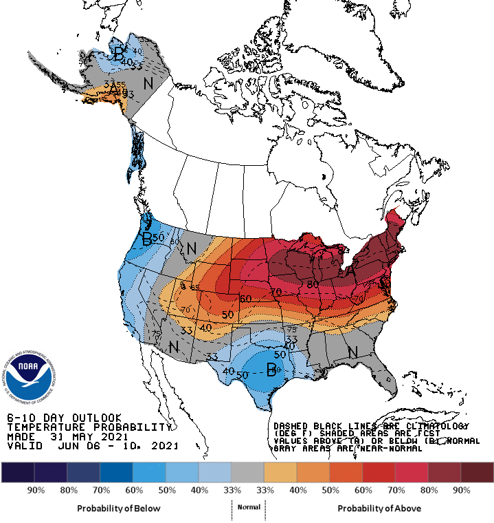
A Heat Hiatus
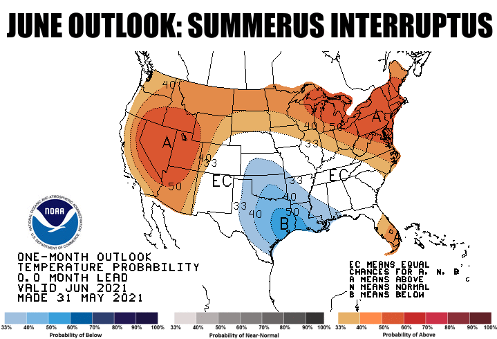
Is your pool still too cold to go jump in without freezing your sweet patootie
off (we'll leave it there)? Are you still grabbing jackets from the closet that
you thought would have been on the top rung by now, put away until October? Well,
you were mostly out of luck during May, and you're gonna be out of luck during
the early part of June at least as we go forward. Now the later into June we
get, the more welcome a cooler-than-normal outlook becomes. But come on, enough
is enough. Let's turn on the heat for awhile.
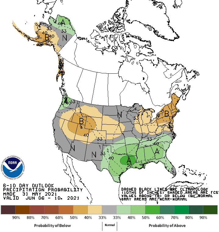
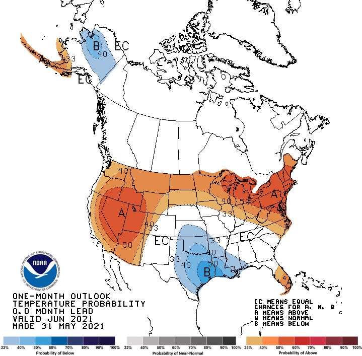
If you see a temperature outlook like that in the summer, it's most definitely
going to be caused by additional precipitation, and the June precip outlook calls
for exactly that.
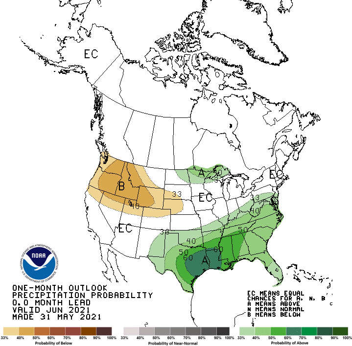
That was basically the problem during May, with lots of rain (nothing new there),
clouds (duh!), and too many cold fronts giving us northwest flow (and we all
know just how painful that can be). It wasn't the low temps being too cold, it
was a lack of any heat during the day, a result of all those clouds and precip.
The moisture and clouds act as a blanket during the night, keeping low
temps up a bit, but as a shade during the day, preventing lots of that sunshine
from reaching the surface. You can see the impact on the Mesonet's departure
from long-term average max and min temps for May. Lows are somewhat normal, but
highs are wayyyy below that long-term average.
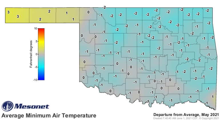
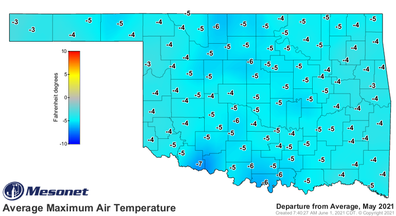
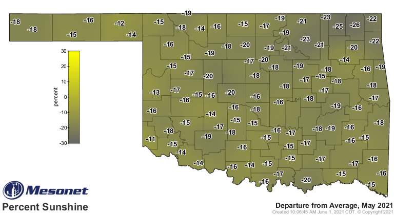
The impact on the percent of possible sunshine during the month was pretty
striking as well.
I suspect you'll see more of the same during June, at least early on. Rain's in
the forecast most of the week, maybe a small break on Thursday-Friday before
we start up again. And more next week.
Depressed or happy? Well, we'll check back with ya at the end of June. As for
now, let's take a look back at May, shall we?
----------------------------------------------------------------------------------
Heat Hiatus Continues During May
June 1, 2021
May’s weather was rather tame by Oklahoma standards, with severe weather
greatly diminished by an abundance of cool, cloudy weather. Plenty of moisture
was to be had, with heavy rains falling right through May’s final day. That is
not to say severe weather was completely absent, but at times flood warnings
were seemingly more prevalent than severe thunderstorm warnings. Only a handful
of tornadoes were reported in the state during May. While the official number
is still under investigation by the National Weather Service, the total will
come in well below the month’s 1950-2020 average of 24.3 twisters. Those that
did touch down were damaging, nonetheless. An EF-1 tornado struck near Roland
on May 3, destroying several outbuildings and damaging homes in the area.
Another EF-1 twister damaged structures near Hanna on the 27th before
dissipating. The month ended on a more violent note as at least two large
tornadoes were reported in Cimarron County on the 29th. The twisters traveled
over open ground mostly, threatening Boise City before dissipating. More
tornadoes were reported in Cimarron County the following night as well.
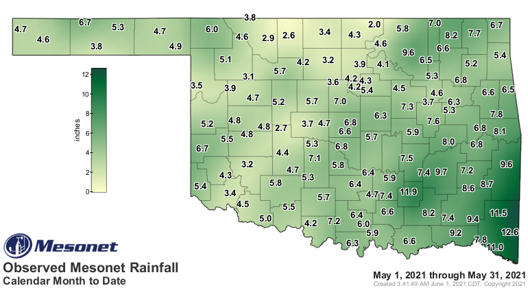
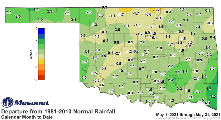
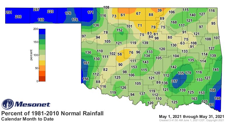
Most of the state saw a surplus of moisture during the month, although a few
areas did suffer from continued dry weather. The statewide average
precipitation total of 5.82 inches was 0.91 inches above normal and ranked as
the 37th wettest May in Oklahoma since records began in 1895. Totals of 5-10
inches were common across much of central through eastern Oklahoma, and again
through the Panhandle. Some areas of north central and southwestern Oklahoma
saw only 2-4 inches for the month, however, to fall on the deficit side of the
ledger. The Mesonet site at Broken Bow led the state with 12.62 inches.
Seventy-seven of the Mesonet’s 120 sites saw at least 5 inches of rain, with 51
of those locations receiving at least 6 inches. Newkirk brought up the rear
with 2.02 inches, one of only four sites with less than 3 inches for the month.
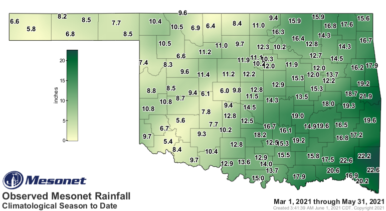
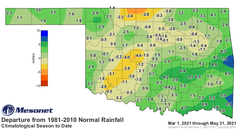
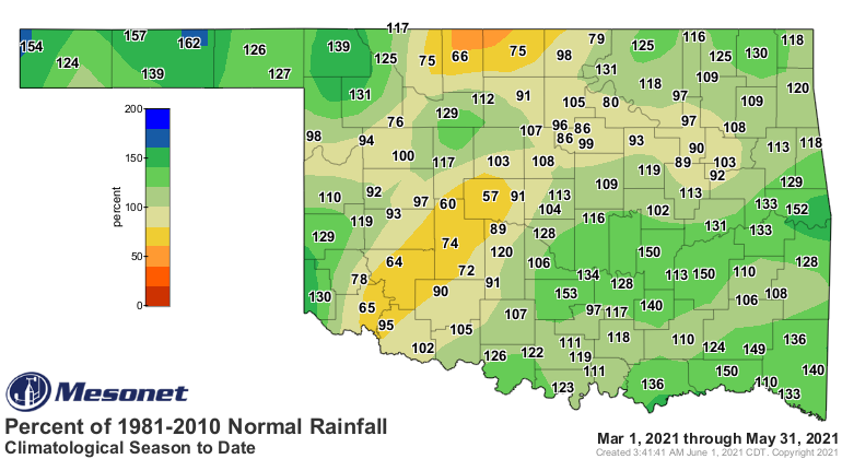
May brought the climatological spring (March-May) to a close as the 30th
wettest on record statewide with an average of 12.44 inches, 1.32 inches above
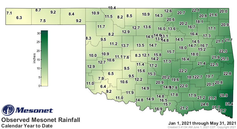
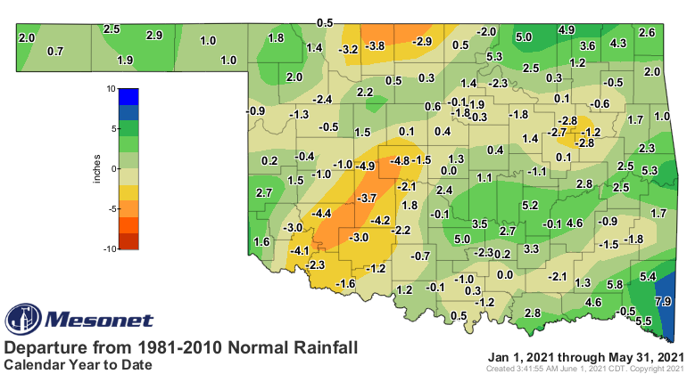
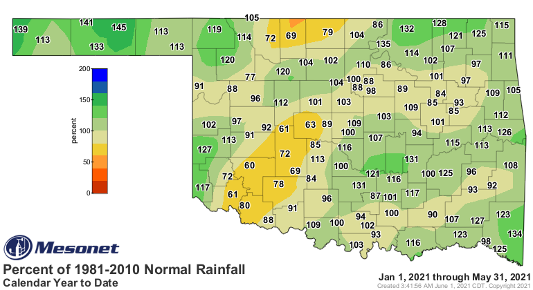
normal. The first 5 months of the year continued on the wet side at 15.48
inches, the 37th wettest January-May on record and 0.97 inches above normal.
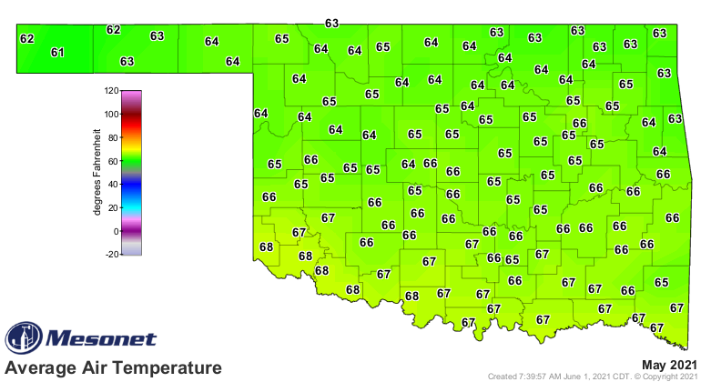
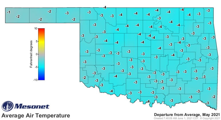
The statewide average temperature was 65.6 degrees according to preliminary
data from the Oklahoma Mesonet, 2.7 degrees below normal and ranked as the 15th
coolest May since 1895. The cooler weather was mainly a result of diminished
high temperatures throughout the month, as opposed to lower minimum
temperatures. Statewide average high temperatures were below their long-term
averages as many as 24 days in May. Only 58 readings of at least 90 degrees
were observed by the 120 Mesonet sites during the month, on just five separate
days. Hollis recorded the month’s highest temperature with 97 degrees on May 8.
Nowata reported the lowest temperature of 35 degrees on May 5, marking April 24
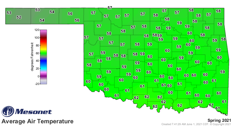
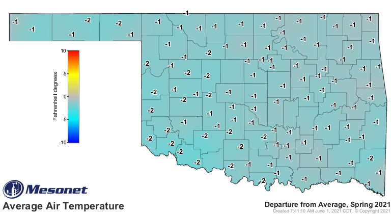
in the Panhandle as Oklahoma’s final spring freeze. Spring finished at 59
degrees, 0.3 degrees below normal to rank as the 63rd coolest March-May on
record. The year remained on the cold side at 49.9 degrees, 1.8 degrees below
normal and the 32nd coolest January-May on record.
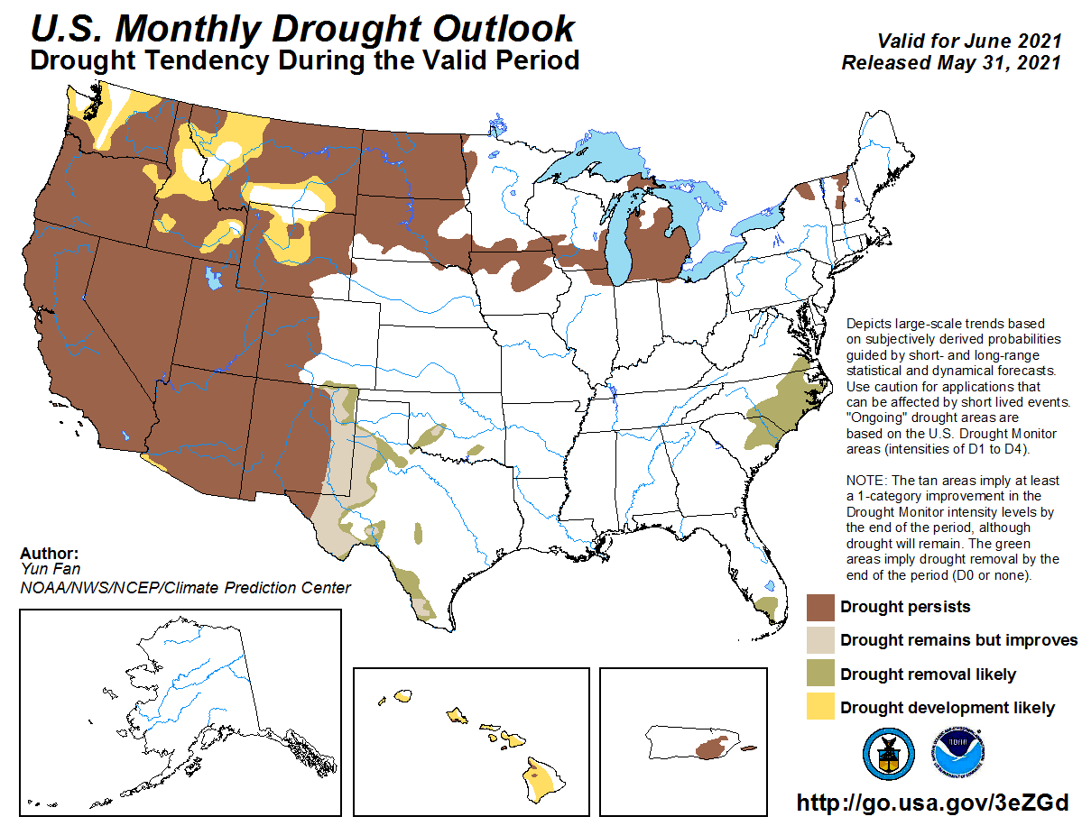
Drought coverage in Oklahoma was reduced by over half during May, from 20
percent of the state at the end of April to less than 8 percent to end May.
Only two small pockets of moderate-to-severe drought were left in southwestern
and south central Oklahoma. The Climate Prediction Center’s (CPC) June outlooks
gave promise to a possible drought free Oklahoma by the end of June. The
outlooks show increased odds for above normal rainfall and below normal
temperatures across virtually the entire state. Given those expectations,
CPC’s June drought outlook calls for improvement or removal of the remaining
areas of drought in Oklahoma by the end of the month.

Gary McManus
State Climatologist
Oklahoma Mesonet
Oklahoma Climatological Survey
(405) 325-2253
gmcmanus@mesonet.org
June 1 in Mesonet History
| Record | Value | Station | Year |
|---|---|---|---|
| Maximum Temperature | 110°F | ALTU | 1998 |
| Minimum Temperature | 44°F | OILT | 2012 |
| Maximum Rainfall | 6.51 inches | OKEM | 2013 |
Mesonet records begin in 1994.
Search by Date
If you're a bit off, don't worry, because just like horseshoes, “almost” counts on the Ticker website!