Ticker for May 3, 2021
MESONET TICKER ... MESONET TICKER ... MESONET TICKER ... MESONET TICKER ...
May 3, 2021 May 3, 2021 May 3, 2021 May 3, 2021
Ah hail

Sure, there was big weather news during April. What is it, you ask? It's the
fourth month of the year, but that's not important right now. We have your
April weather summary below. Let's talk about tonight, which is somewhat related
to April's "big" news. What is it, you say? Nice try. We will see another chance
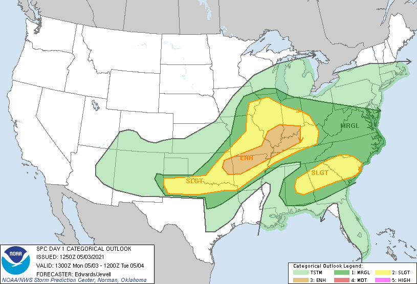
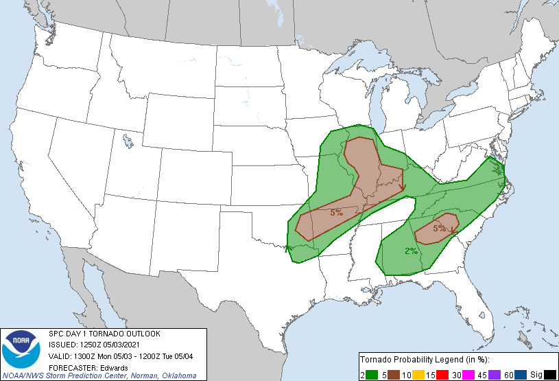
for severe weather, and while the big attention getter, our great nemesis the
tornado COULD make an appearance, chances are pretty low. Big hail, on the
other hand, is a bit more likely (as seen above). Wind will also be a hazard
with some of the bigger storms tonight. Here are the outlooks from SPC showing
the areas that are at higher risk.

Best to stay weather aware throughout the day to stay ahead of any developing
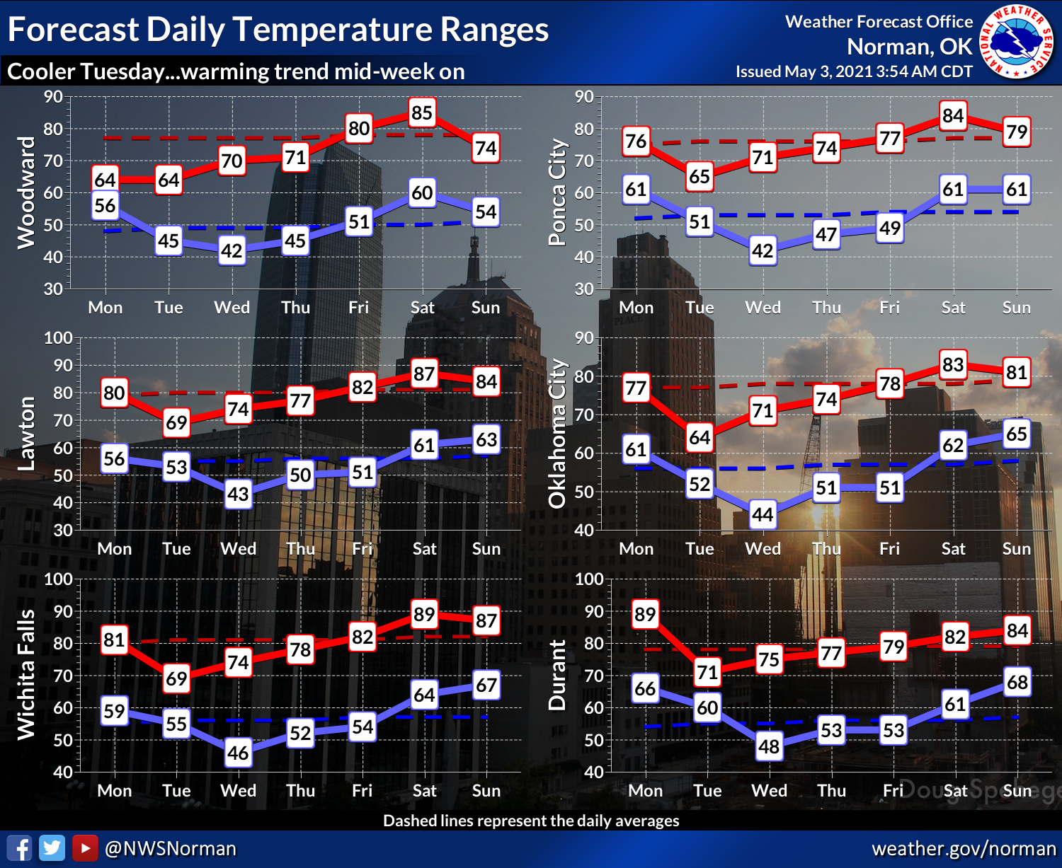
changes, which normally occur as the event itself progresses. As this system
moves out and a cold front enters, watch for a cool day tomorrow and then
another general warm up through the week.

Maybe a return to storm chances this weekend, and hopefully some moisture across
northwestern OK, where it is sorely needed.

Now let's go back to April and check out all those fun and exciting weather
blurbs you've been hankering for.
----------------------------------------------------------------------------------
Cold April Feels Severe Weather Impacts
April 3, 2021
Cool weather helped keep severe weather at bay in Oklahoma throughout much of
April. A late spring freeze—damaging in its own right—punctuated the scarcity of
severe weather during the month’s first three weeks. The cold eventually gave way
to an emphatic exclamation point, however, when tornadoes, flooding, high winds,
and a hail-borne catastrophe struck during April’s final week. At least four
confirmed tornadoes touched on April 28, including an EF-1 twister that struck
near Pauls Valley at the stroke of midnight. The tornado damaged homes and
outbuildings on at least two farms before dissipating. Two more tornadoes
struck near Stilwell around 6 a.m., and another near Crowder later that morning.

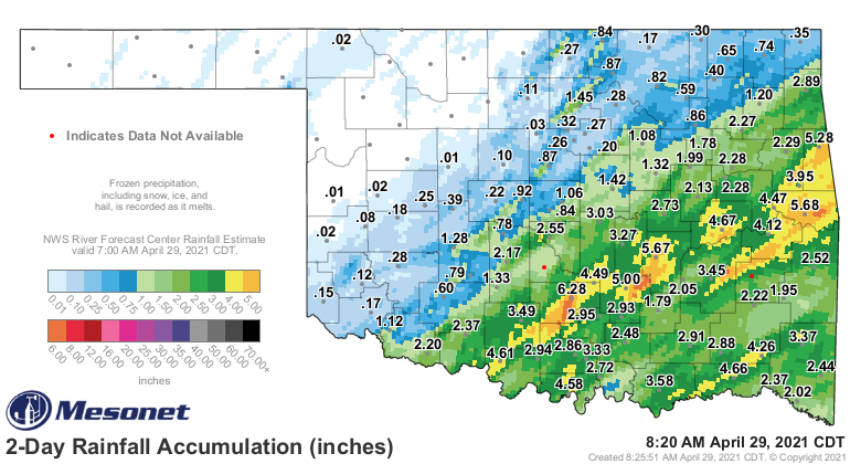
Heavy rains of 4-6 inches fell over a wide area from south central through east
central Oklahoma, prompting flood warnings. Pauls Valley recorded over 6 inches
of rain overnight on the 28th that left downtown buildings flooded and stranded
motorists requiring water rescues.
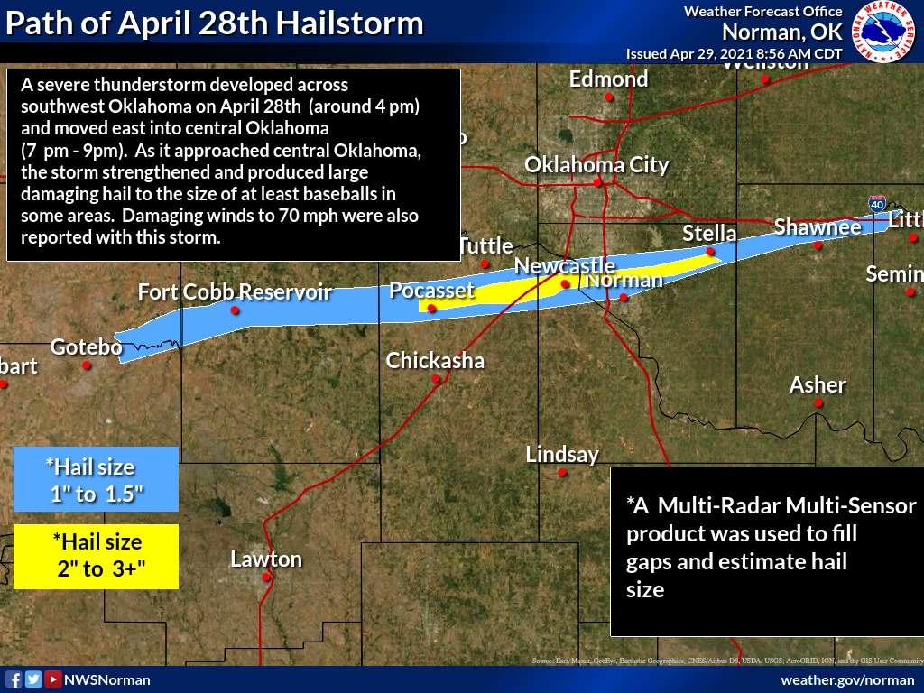
Despite the early fireworks, the big show came later that night. A large,
solitary supercell thunderstorm began dropping quarter-size hail near Gotebo
that evening. As the storm approached Grady County, the hail size increased to
golf balls until growing to at least baseball size as it entered the Newcastle
and Norman area. The storm laid a footprint of giant hail through Norman from
west to east, hammering cars and damaging homes in its path. The destructive
force of the hail was enhanced by winds of over 70 mph.
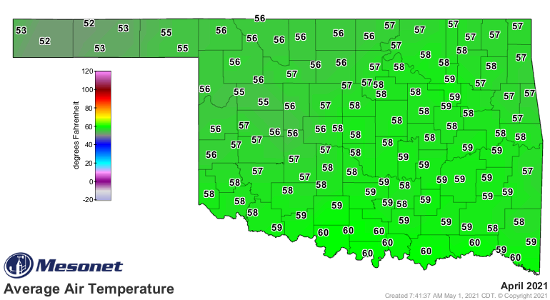
A hard freeze saw temperatures drop into the mid-20s over nearly the entire
state April 20-21. This freeze was particularly jarring since some locations
had not experienced freezing temperatures since early March. According to
preliminary data from the Oklahoma Mesonet, the statewide average temperature
finished at 57.2 degrees, 2.1 degrees below normal and ranked as the 22nd
coolest April since records began in 1895. The state’s highest temperature was
93 degrees at Beaver and Slapout on April 25. The lowest reading of 21 degrees
came on April’s first day at Eva in the central Panhandle. The first four
months of the year fell on the cool side at 45.8 degrees, 1.6 degrees below
normal and ranked as the 45th coolest January-April on record.


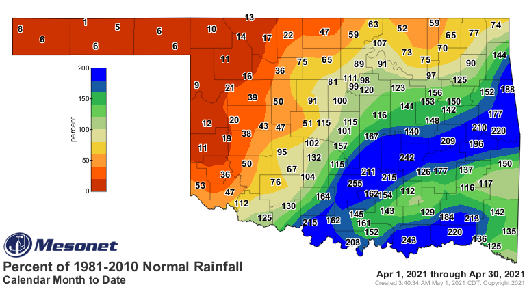
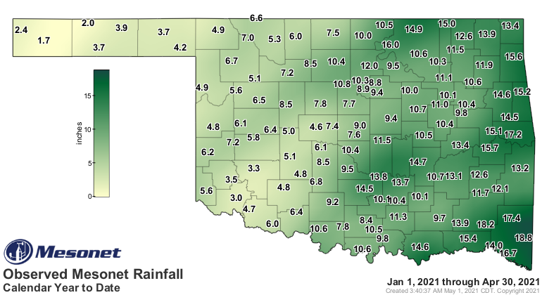
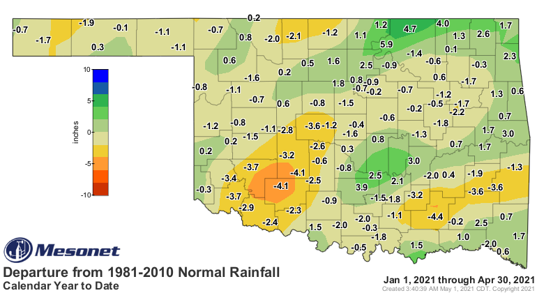
Interstate 44 was a curious dividing line between feast or famine rainfall
during April. Areas to the southeast saw plenty of beneficial moisture while
areas to the northwest went largely without significant rainfall. Totals to
the southeast of I-44 ranged from 3-9 inches, with the Mesonet site at Sallisaw
leading the state at 10.09 inches. Totals dwindled rapidly to the northwest,
generally falling below an inch. The Mesonet site at Eva had the lowest tally
at 0.02 inches for the month. Regionally, the Panhandle experienced its second
driest April on record with an average of 0.11 inches, 1.55 inches below normal.
East central Oklahoma’s total of 7.47 inches was its 11th wettest, 3.24 inches
above normal. The year fell on the wet side at 9.82 inches, 0.13 inches above
normal and ranked as the 41st wettest January-April on record.



Drought nearly doubled during April according to the U.S. Drought Monitor,
with coverage expanding from about 11 percent of Oklahoma at the end of March
to 20 percent at the end of April. Much of that increase came across south
central Oklahoma, where long-term deficits had been expanding since late fall
2020, and over the western third of Oklahoma with its shorter-term deficits.
Longstanding drought in the western Panhandle continued unabated during April.
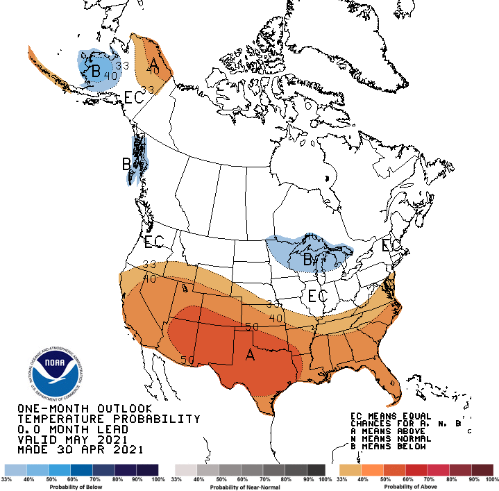
The May temperature outlook from the Climate Prediction Center indicates
increased odds for above normal temperatures for all of Oklahoma, but
especially the southwestern half of the state. The precipitation outlook sees
increased chances of drier than normal weather across far western Oklahoma and
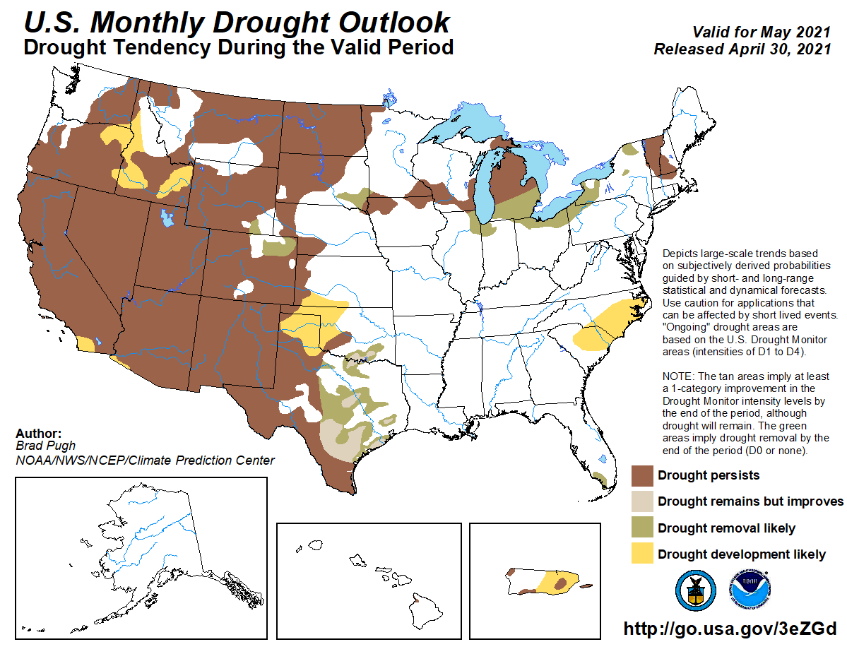
the Panhandle, but above normal precipitation in the far southeast. CPC’s May
drought outlook sees drought development as “likely” across the western
one-third of the state, but drought removal or improvement across south central
Oklahoma.

Gary McManus
State Climatologist
Oklahoma Mesonet
Oklahoma Climatological Survey
(405) 325-2253
gmcmanus@mesonet.org
May 3 in Mesonet History
| Record | Value | Station | Year |
|---|---|---|---|
| Maximum Temperature | 101°F | ALTU | 2012 |
| Minimum Temperature | 22°F | BOIS | 2013 |
| Maximum Rainfall | 3.14 inches | MCAL | 2021 |
Mesonet records begin in 1994.
Search by Date
If you're a bit off, don't worry, because just like horseshoes, “almost” counts on the Ticker website!