Ticker for March 1, 2021
MESONET TICKER ... MESONET TICKER ... MESONET TICKER ... MESONET TICKER ...
March 1, 2021 March 1, 2021 March 1, 2021 March 1, 2021
A February to not remember
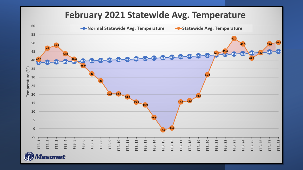
Hey now, I had to relive February to write that summary below, so why shouldn't
you have to as well? Okay, if you don't want to, forget the graphic above, and
don't skip to below the break. However, if you do skip, you'll miss out on all
sorts of fantastical and wonderful tidbits, like it was cold, and it was really
cold, and cold stinks, and so does snow, and I wish it was summer, etc. etc.
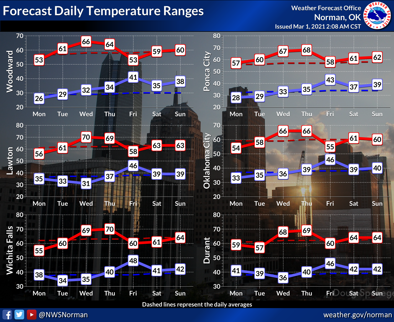
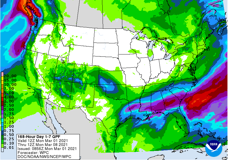
As for this week, expect mild (i.e., blessedly boring) conditions with a chance
of rain today in southern OK and another chance Thursday into Friday. The
forecast rain totals are reversed from what we've seen recently, with the
highest amounts in the far northwest.
And now, back to February for a recap of all its nastiness. We could concentrate
on the positives in February? Okay, I'll list them off here:
It was 81 degrees on Feb. 23.
What, you're still here?
----------------------------------------------------------------------------------
Historically Frigid February Punctuates Winter
March 1, 2021
Oklahoma experienced a historic cold air event during February, boosting the
month into the company of other legendary frozen periods from calendar pages
long torn away and discarded. February 1895, February 1899, and January 1930
all suffered through exceedingly long cold spells. More recently, December 1983
still lives in the minds of many Oklahomans as the bellwether of cold months,
which followed those winters of the late 1970s when bone-chilling cold was
simply a way of life; but those cold times were more than 37 years ago. Even
February 2011 and its all-time state record low temperature of minus 31 degrees
at Nowata, and all-time low wind chill of minus 47 degrees at Medford, still
managed to finish only 2 degrees below normal. All the more shocking then to
see the return of a generational winter blast, complete with ice, snow, and
plenty of misery.
A seasonable first few days of February soon gave way to a preliminary blast of
Arctic air on Feb. 7, dropping temperatures across the state into the 20s and
30s. Several rounds of freezing drizzle provided treacherous travel conditions
across the state. Temperatures continued to plummet over the next 7-10 days,
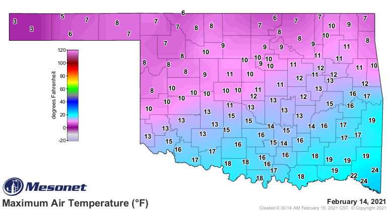
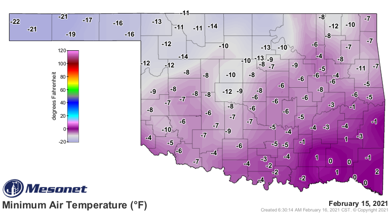
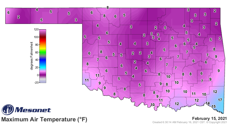
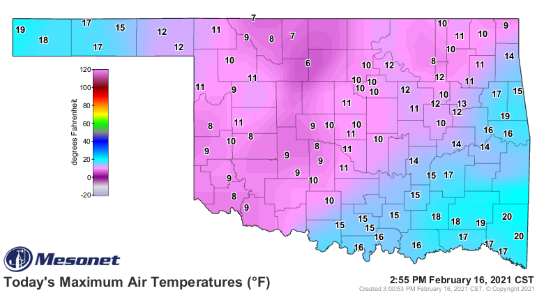
culminating with historically cold air Feb. 14-16. The statewide average
temperature on Feb. 15 was minus 0.7 degrees, more than 40 degrees below normal
and the single coldest day statewide since at least 1915. Sparse station
coverage prior to 1915 prevented accurate statewide estimates for comparison.
The previous record coldest day was Dec. 22, 1989, with an average of 1.9
degrees. Feb. 15-16 and Feb. 14-16 also set records as the coldest 2-day and
3-day periods at -0.1 degrees and 2.1 degrees, respectively. Lowest minimum and
maximum temperature records fell throughout the state over those days. The
records for 4-day through 7-day periods were all set in Dec. 1983.
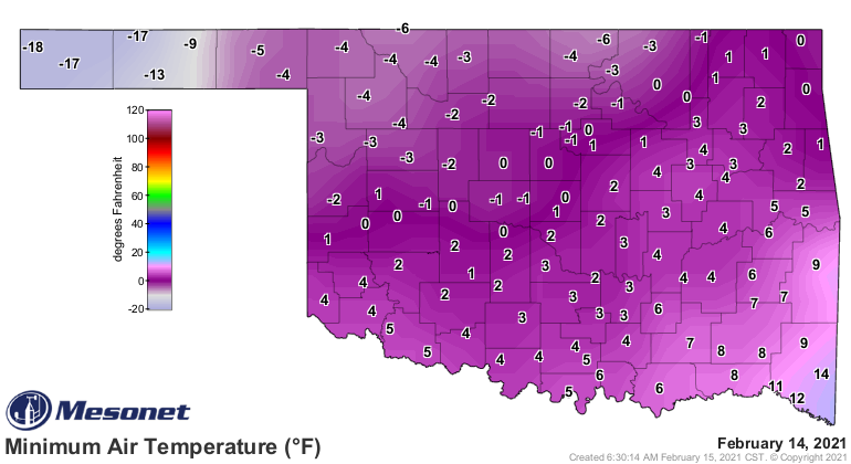
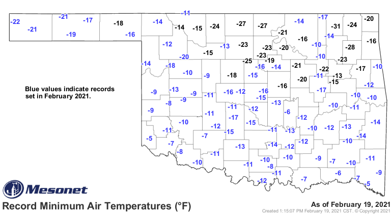
Unlike many of the state’s garden variety cold spells, this event extended to
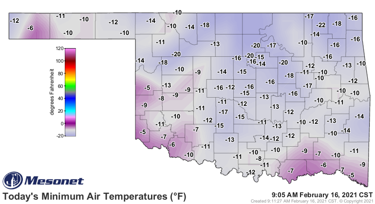
Oklahoma’s southern border and beyond. Ninety-six of the Mesonet’s 120 sites
recorded their all-time record low temperature on either Feb. 15 or Feb. 16.
Mesonet temperature data go back to 1997.
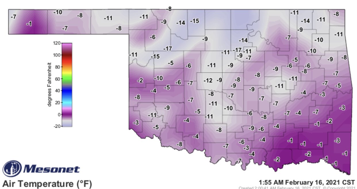
Overnight on Feb. 16, all 120 Mesonet sites were below zero for the first time
in its history.
The Mesonet site at Broken Bow reached a low of minus 9 degrees on Feb. 16,
topping the town’s previous all-time record low of minus 5 degrees set at the
National Weather Service’s (NWS) cooperative observer site on both Jan. 12 and
Jan. 22, 1918. The cooperative site at Idabel reached a low of minus 12 degrees
the morning of the 16th, breaking the previous all-time record low of minus 11
degrees from Feb. 2, 1951. Healdton’s minus 17 degrees from the 16th now tops
all its record lows dating back to 1894. Oklahoma City’s minus 14 degrees on
Feb. 16 was its second lowest temperature on record behind minus 17 degrees from
Feb. 12, 1899. Tulsa’s minus 14 degrees, also on the 16th, is its fourth lowest
temperature dating back to 1905, with a top mark of minus 16 degrees from Jan.
22, 1930. At least eight long-term NWS sites with periods of record of more
than 70 years broke their all-time record lows during the event. Even the high
temperatures were extraordinarily cold, at times below the record daily low
temperatures. Billings and Medford both recorded high temperatures of 1
degree—Billings on the 16th and Medford on the 15th—which would have broken the
previous record *low* temperatures for the day at those locations. That feat
was repeated across the state numerous times between Feb. 14 and Feb. 16.
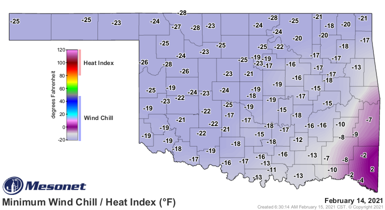
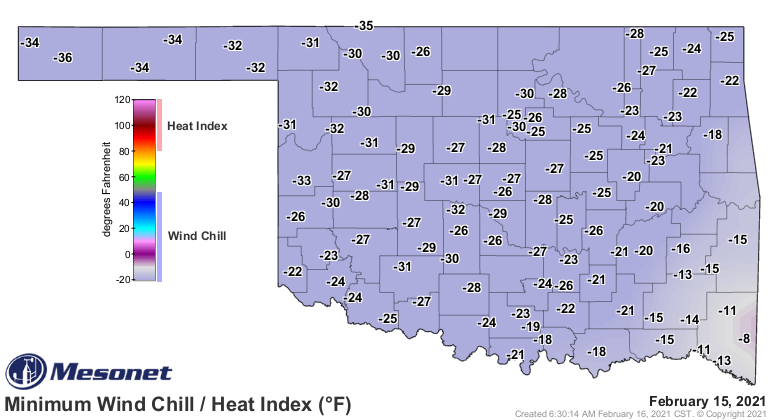
The Oklahoma Mesonet’s 120 stations recorded wind chill values of minus 10
degrees or lower 439 times between Feb. 12 and Feb. 19, bottoming out at minus
36 degrees at Boise City on the 15th. The state’s all-time record lowest wind
chill is minus 47 degrees on Feb. 10, 2011, at Medford. There were 38 wind
chills of less than minus 30 degrees, and 251 less than minus 20 degrees.
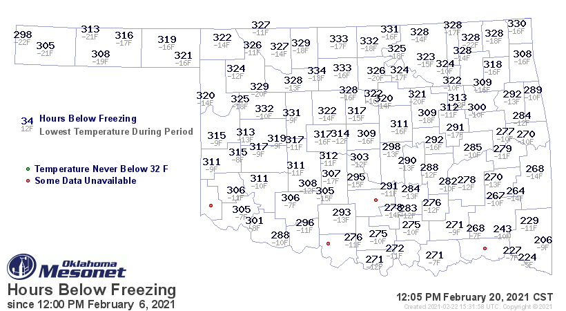
Temperatures slowly climbed back to something akin to seasonable by Feb. 20
when every site in the state broke the freezing barrier, many for the first
time since Feb. 7. That 13-day span matches what many locations experienced in
the deep freeze of December 1983. The Mesonet site at Lahoma spent the most
time under the freezing mark at 334 hours from the afternoon of Feb. 6 through
the afternoon of Feb. 20. Even locations in far southeastern Oklahoma spent
over 200 hours below freezing during that time.
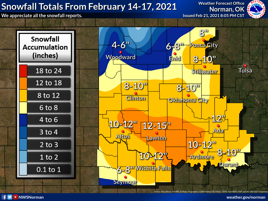
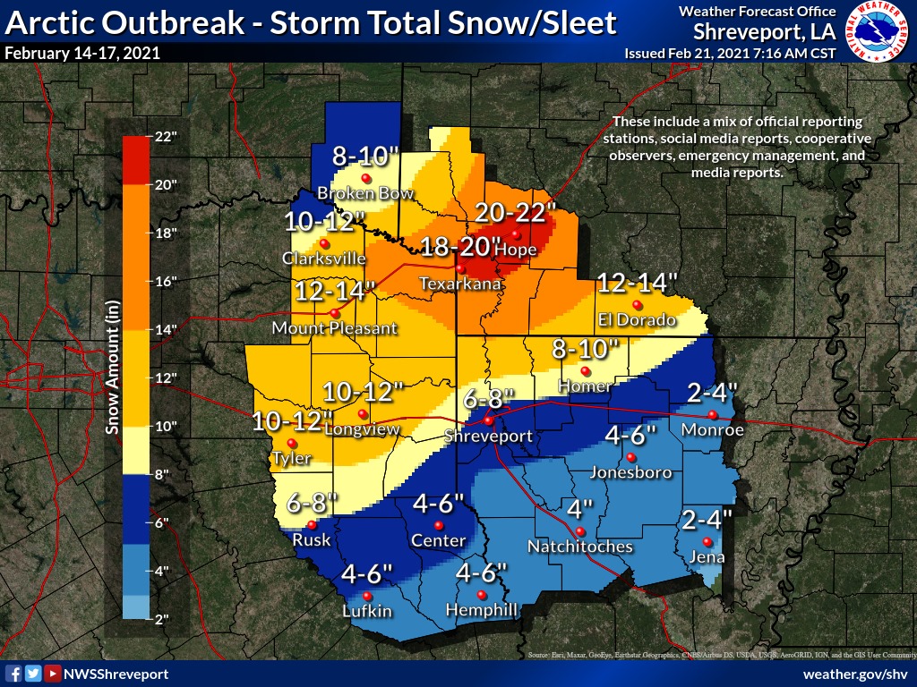
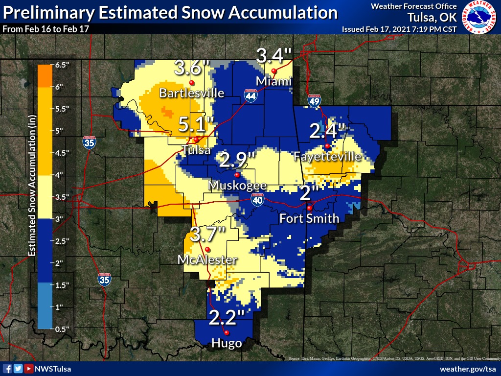
Another key similarity to past extreme cold events was an abundance of frozen
precipitation. Snow shovels were still busy clearing sidewalks and driveways
after the first storm over Feb. 14-15 when the second storm hit on Feb. 16-17.
Between the two snowfalls, totals of 5-15 inches were common across the main
body of the state, with a bit less in the far northwest and the Panhandle. The
NWS cooperative observer at Roosevelt in southwestern Oklahoma led the state
with an official report 17 inches of snow, although unofficial reports of
higher totals were scattered around. Strong winds gusting to over 40 mph pushed
the dry snow into piles several feet high, drifting roads shut and creating
hazardous driving conditions.
The frosty 2-week span took a tremendous toll on Oklahoma. A state of emergency
was declared by Gov. Kevin Stitt on Feb. 12 for all 77 Oklahoma counties, and
President Joe Biden declared all 77 counties as federal disaster areas on Feb.
18 at the request of Gov. Stitt. The Oklahoma Department of Emergency
Management and Homeland Security (ODEMHS) reported a total of 750
weather-related injures, with 538 of those being due to slips or falls. The
cold placed immense strain on the region’s power suppliers and infrastructure,
forcing rolling blackouts of electricity and cutbacks in gas service. The
extended freezing weather damaged more than 120 public water systems according
to ODEMHS, and many residences and business across the state faced frozen and
burst pipes. The damage to agriculture was still being assessed, including harm
to winter crops and livestock.
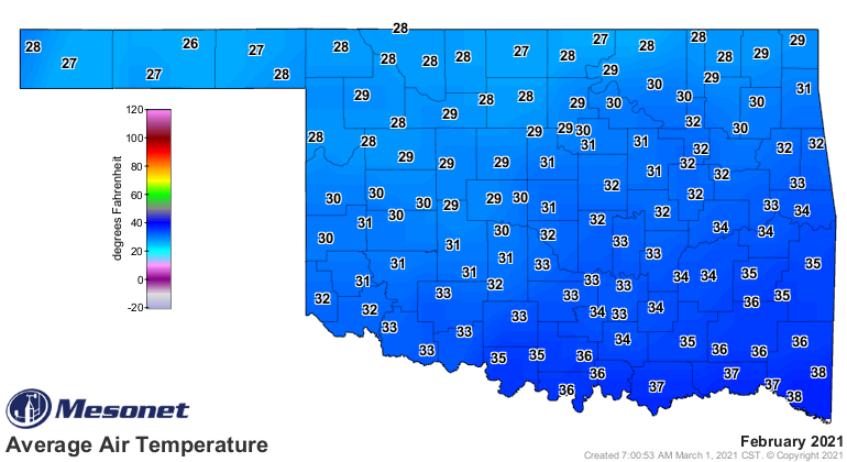
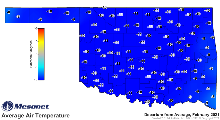
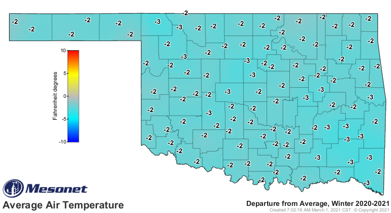
The statewide average temperature for the month was 31 degrees according to
preliminary data from the Oklahoma Mesonet, the sixth coldest February on
record and an astounding 11.1 degrees below normal. The record belongs to
February 1905 at 27.6 degrees. February was also the 20th coldest of any
calendar month out of a possible 1513 months dating back to 1895, well short of
January 1940’s record lowest of 23.7 degrees. The lowest temperature of the
month was minus 22 degrees, recorded at Kenton on Feb. 15 and Nowata on Feb.
16. Those are the lowest reported temperatures in Oklahoma since Nowata set the
all-time record low of minus 31 degrees on Feb. 10, 2011. The state’s highest
temperature of 81 degrees came at Waurika on Feb. 23. Despite warmer than
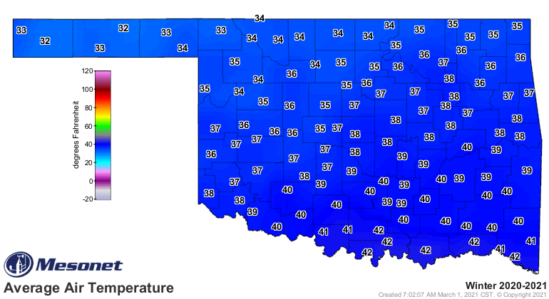
normal weather for December and January, the climatological winter
(December-February) finished 2 degrees below normal at 37.4 degrees statewide,
the 29th coolest winter on record.
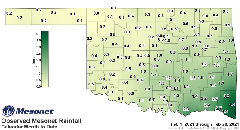
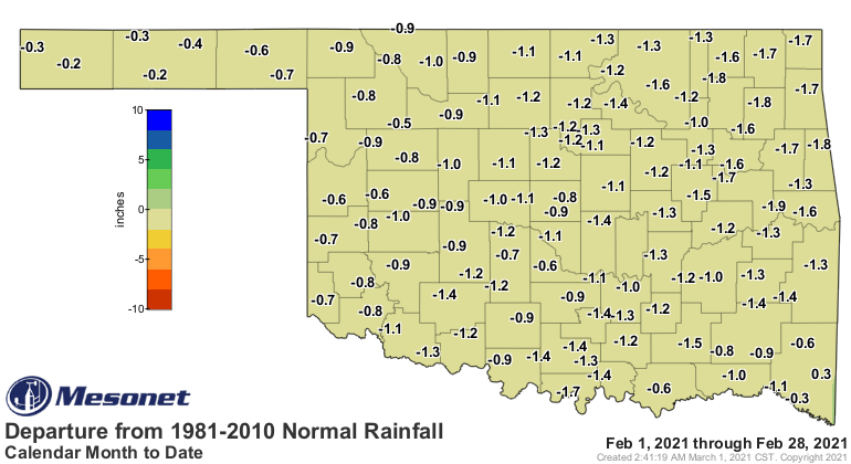
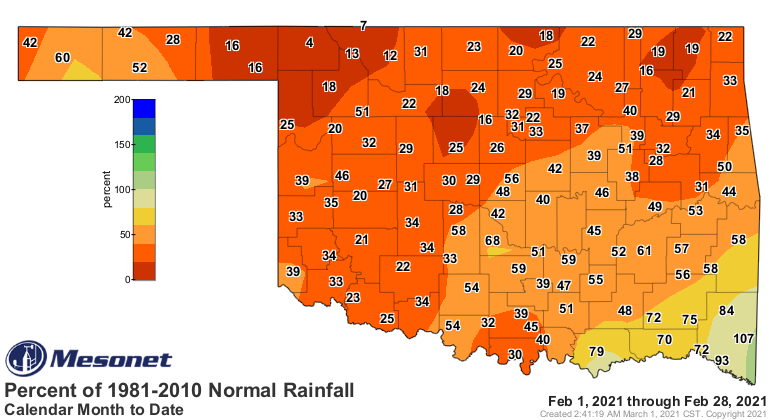
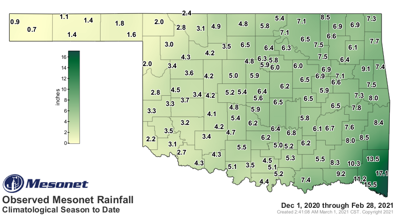
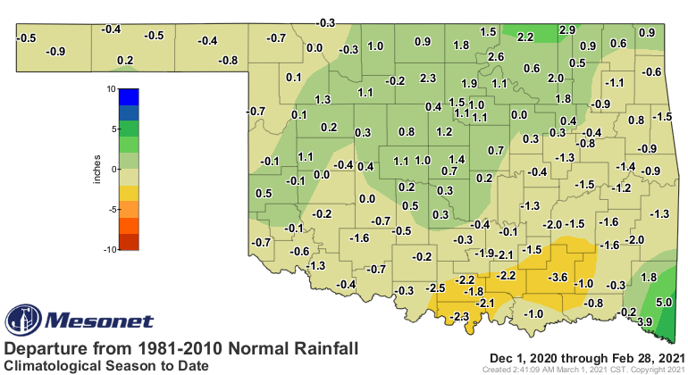
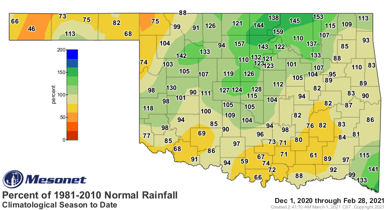
The heavy snows were unfortunately light on moisture. Rains on February’s final
two days helped to lessen deficits that had built during the month, but every
section of the state finished below normal. The statewide average for the month
finished at 0.78 inches, 1.05 inches below normal and ranked as the 27th driest
February on record. Broken Bow led the state with 4.22 inches of rain. Totals
dropped quickly to the northwest, however, with much of northern and western
Oklahoma seeing less than a third of an inch of liquid moisture. Buffalo had a
paltry 0.04 inches for the month. Eighty-six of the Mesonet’s 120 sites
recorded less than an inch of rain for the month, and 54 recorded less than a
half-inch. Deficits ranged from less than a half-inch in the Panhandle to 1-2
inches over the main body of the state. The winter in its entirety fared a bit
better with a statewide average of 5.23 inches, 0.22 inches below normal, to
rank as the 51st wettest on record.
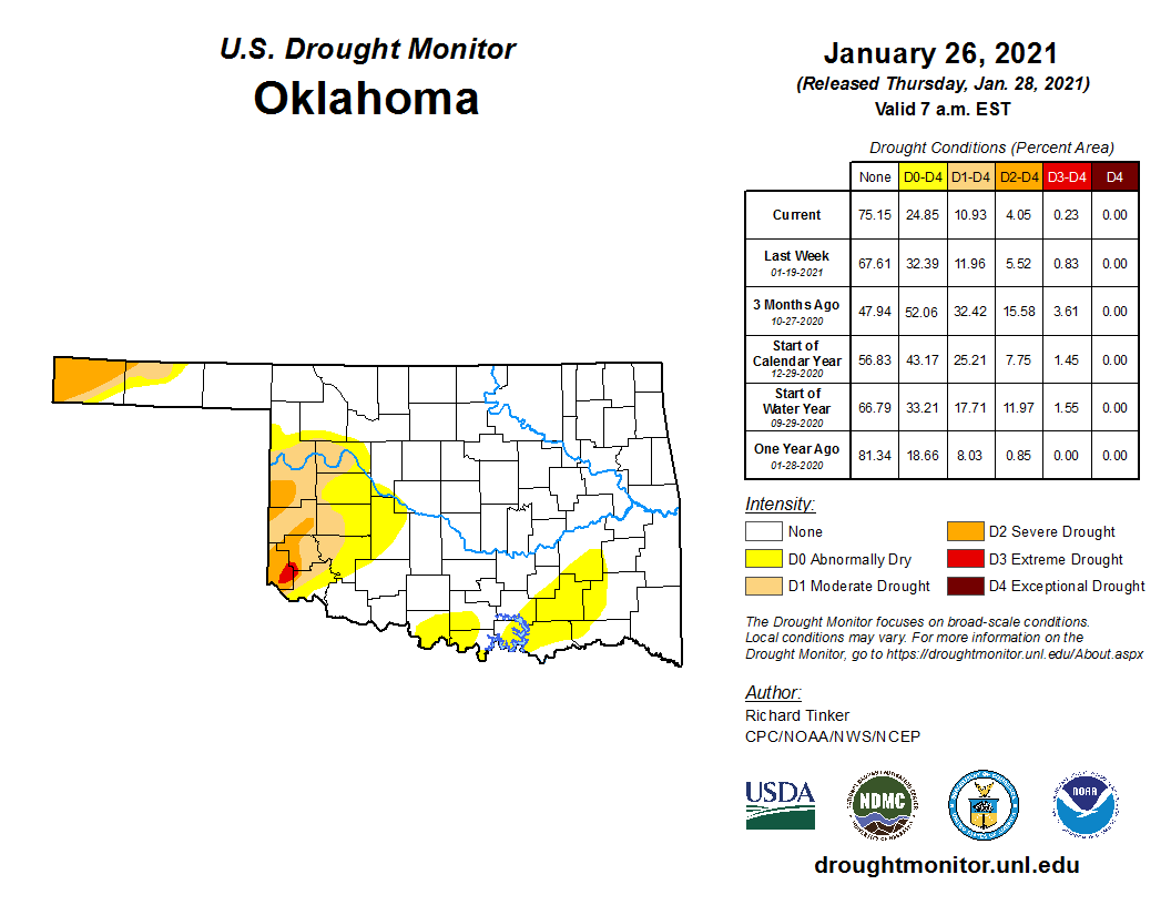
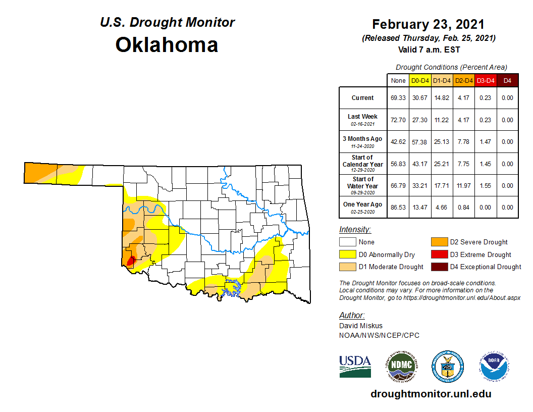
Drought was mostly unchanged during February, given the frigid conditions.
Continued dry weather forced intensification across south central and
southeastern Oklahoma, however, with a new area of moderate drought indicated
in those areas on the month’s final U.S. Drought Monitor map. Only 15% of the
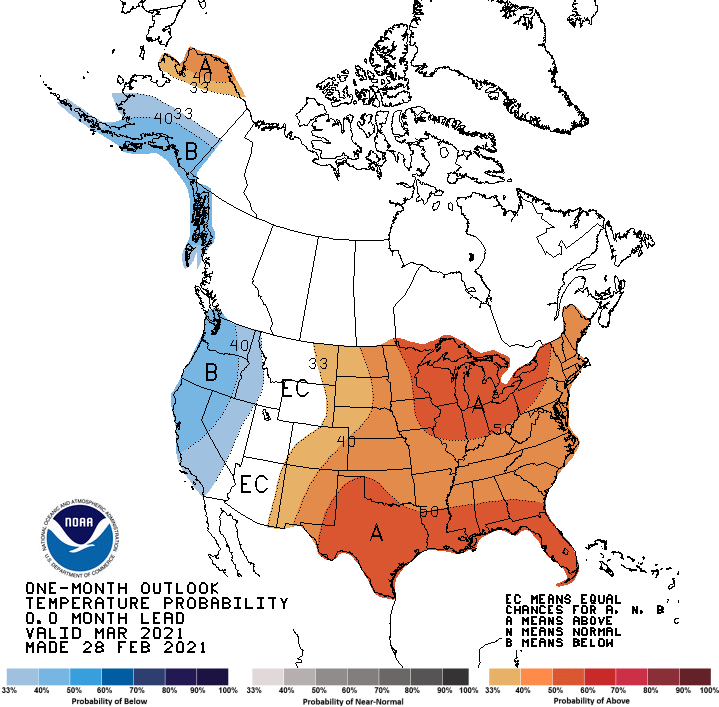
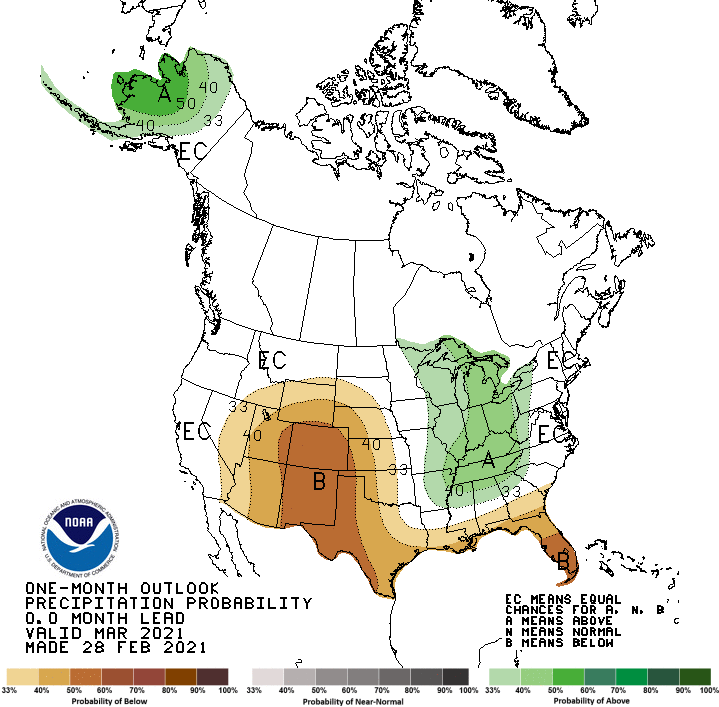
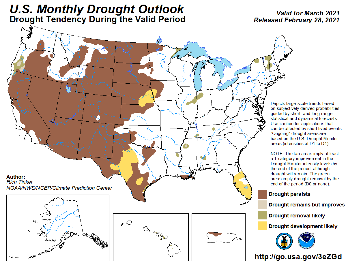
state remained in drought at the end of February. The March outlooks from the
Climate Prediction Center (CPC) show increased odds of above normal
temperatures across the entire state—but especially southwestern Oklahoma—and
below normal precipitation over the western two-thirds of the state. Those odds
for drier weather are greater across the western one-third, but especially the
western Panhandle. CPC’s drought outlook showed no changes to the drought
depiction are expected through March.
Gary McManus
State Climatologist
Oklahoma Mesonet
Oklahoma Climatological Survey
(405) 325-2253
gmcmanus@mesonet.org
March 1 in Mesonet History
| Record | Value | Station | Year |
|---|---|---|---|
| Maximum Temperature | 95°F | NEWP | 2006 |
| Minimum Temperature | 7°F | GOOD | 2001 |
| Maximum Rainfall | 1.86 inches | HUGO | 1997 |
Mesonet records begin in 1994.
Search by Date
If you're a bit off, don't worry, because just like horseshoes, “almost” counts on the Ticker website!