Ticker for February 16, 2021
MESONET TICKER ... MESONET TICKER ... MESONET TICKER ... MESONET TICKER ...
February 16, 2021 February 16, 2021 February 16, 2021 February 16, 2021
All hail February 15!
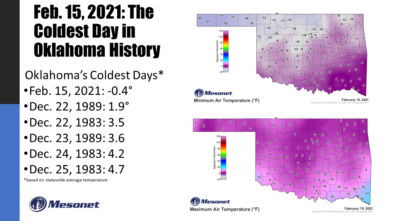
Wow, I can't believe we finally did it.
(I had another way to say it, but I don't want to get fired...think Charlton
Heston at the end of "the Planet of the Apes)!
It was actually the temperatures continuing to fall throughout the day that did
it, I think. That brought the overall statewide average temperature (all the highs
and lows averaged together) down to -0.4 degrees to beat Dec. 22, 1989's 1.9
degrees out as the coldest day in state history. That makes the last couple of
days the coldest and the 16th coldest on record.
-***-
Date Statewide Avg. T
02/15/2021 -0.4F
12/22/1989 1.9F
12/22/1983 3.5F
12/23/1989 3.6F
12/24/1983 4.2F
12/25/1983 4.7F
01/04/1947 4.7F
01/17/1930 5.2F
01/22/1930 5.5F
12/23/1983 5.6F
01/12/1918 5.6F
01/04/1959 5.8F
01/18/1930 6.3F
12/22/1990 6.5F
02/08/1933 6.5F
02/14/2021 6.7F
-****-
So combined, the last two days are now the SECOND coldest two-day period in
state history.
-***-
2-Day Period Statewide Average T
Dec. 22-23, 1989 2.7F
Feb. 14-15, 2021 3.1F
Dec. 24-25, 1983 4.4F
Dec. 22-23, 1983 4.6F
Dec. 23-24, 1983 4.9F
-****-
You see lots of dubious periods there that you don't want to be associated with;
namely, Christmastime 1983 and 1989! But there you go. And this is all occurring
during a period where the winters are certainly warmer than they were back then,
which makes it even more astounding. Check out this graph of statewide average
temperatures from 1895-2020, and how much different our winters have been over
the last couple of decades vs. those of the previous few decades.
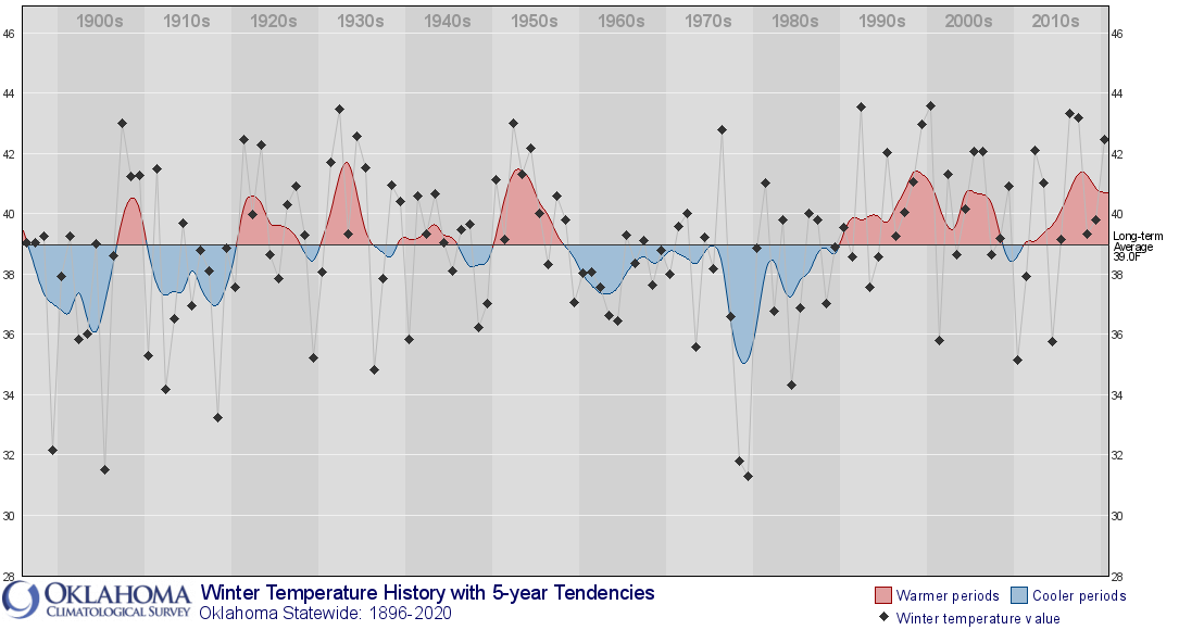
This winter was actually headed towards being warmer than normal as well, but
this deep freeze might be enough to drag the whole thing back below normal
instead. The first two months of the climatological winter, which runs December-
February, have been on the warm side at 1.9 degrees above normal. The statewide
average of 40.2 degrees ranks as the 30th warmest December-January on record. And
February was running above normal as well until it all came crashing down
with a visit from the arctic circle.
Today will probably be cold enough to vault yesterday-today to the coldest tow-
day period on record, and maybe enough for Feb. 16 to take over as the coldest
day in state history from yesterday. Our lows are certainly on schedule. I
believe the highs will preclude obtaining the record, however.
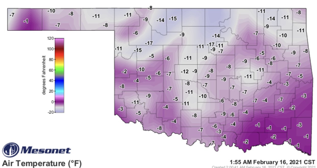
(Pardon the holes in the maps...state communication lines are having trouble
with the weather).
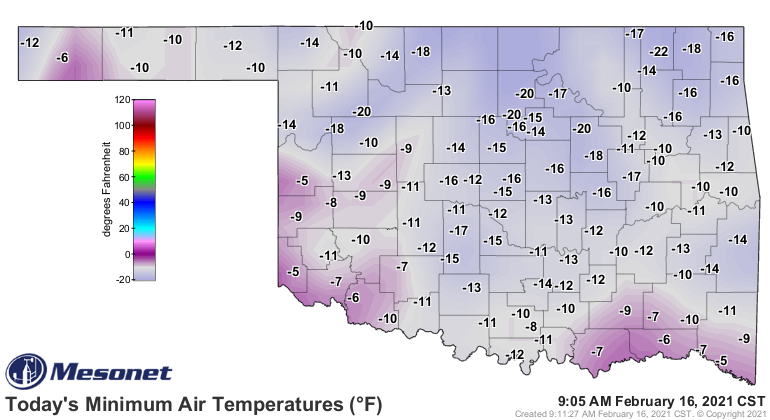
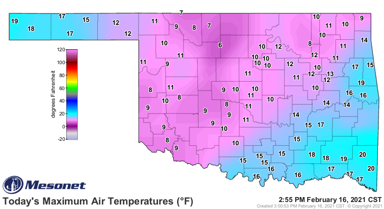
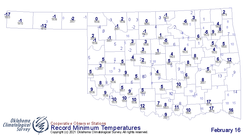
You can see from that low-temperature map that lots of records fell today, not
only record lows for February 16, but all-time lows for locations as well.
Here are the historical lows for today. We blew those out of the water. Frozen
water, but water nonetheless.
And for the first (and maybe last) time in Oklahoma Mesonet history, all sites
were below zero simultaneously. With the communication issues, as noted
previously, we have a few holes in the map. But locations in northern Texas
were below zero as well, and the stations in northern Oklahoma were obviously
going to be below zero.
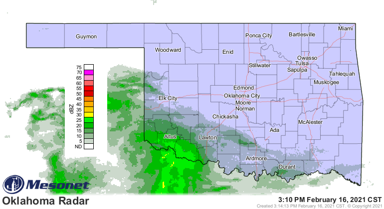
I won't bother talking about the snow, even as the second snowstorm has already
begun across the southwest.
So stay safe, stay warm, and try and forget the statewide average temperature
yesterday was BELOW ZERO for the first time on record.
Gary McManus
State Climatologist
Oklahoma Mesonet
Oklahoma Climatological Survey
(405) 325-2253
gmcmanus@mesonet.org
February 16 in Mesonet History
| Record | Value | Station | Year |
|---|---|---|---|
| Maximum Temperature | 85°F | HOLL | 2011 |
| Minimum Temperature | -22°F | NOWA | 2021 |
| Maximum Rainfall | 3.37 inches | TALI | 2008 |
Mesonet records begin in 1994.
Search by Date
If you're a bit off, don't worry, because just like horseshoes, “almost” counts on the Ticker website!