Ticker for October 1, 2020
MESONET TICKER ... MESONET TICKER ... MESONET TICKER ... MESONET TICKER ...
October 1, 2020 October 1, 2020 October 1, 2020 October 1, 2020
Dessicated pumpkins
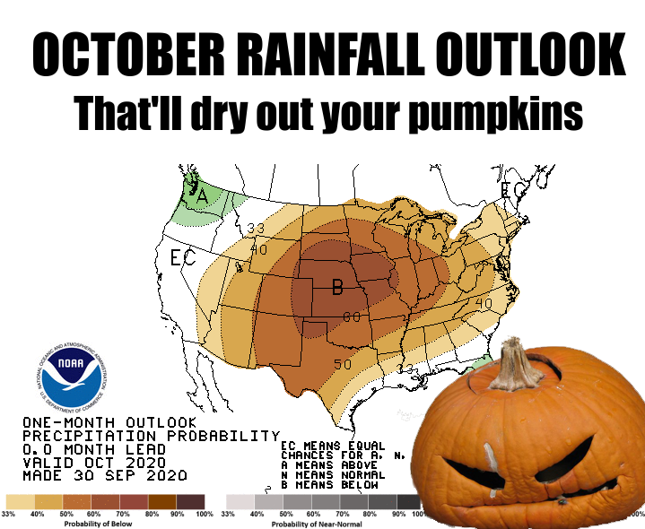
You know things have gone kerflooey when you spend about 30 minutes trying to
convince yourself when talking about the previous month's weather that "A
historic" is proper over "An historic." In other words, historic and weather
are often a bad mix. And while THE historic (HA! Just don't use "a" or "an" and
you're always gold. A nother lesson learned. Wait. Dang it!) cold snap back on
September 9 stole the headlines this summary, the big news is, in reality, the
looming dryness that is being predicted and outlooked and screamed from the
treetops, partially due to the La Nina that has emerged out in the equatorial
pacific.
http://ticker.mesonet.org/select.php?mo=09&da=16&yr=2020
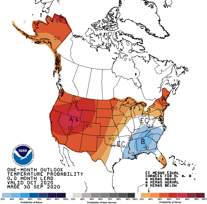
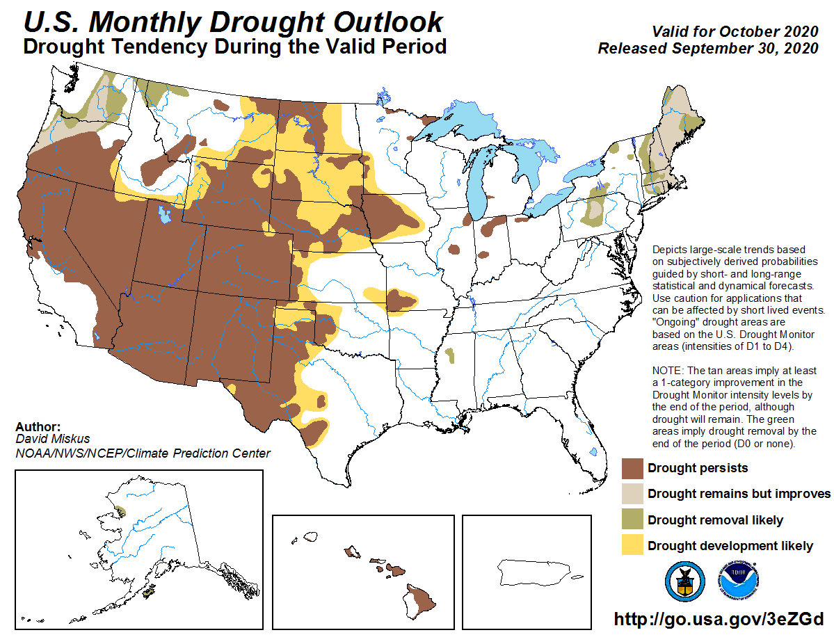
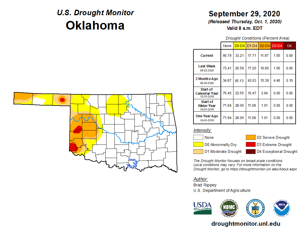
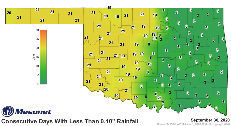
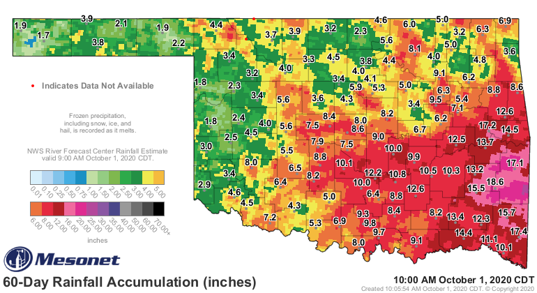
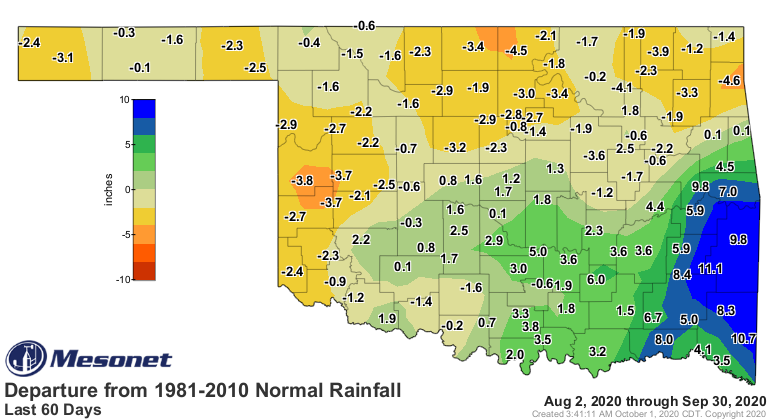
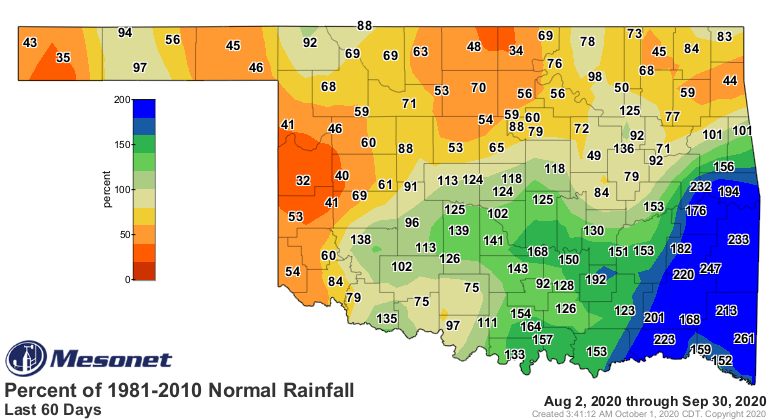
These outlooks for October are really nasty, especially given the
lack of rain across northern and western Oklahoma over the last couple of
months. The last few weeks have been particularly dry. I don't think the CPC
forecasters went quite far enough to the east with the possible drought
expansion across northern Oklahoma, so keep that in mind. Here's why.
If I had just planted wheat, or was about to plant wheat, I'd be pretty
concerned about the outlooks for the coming months. Some are dusting it in
hoping for a good rain to at least get germination. Others have already planted
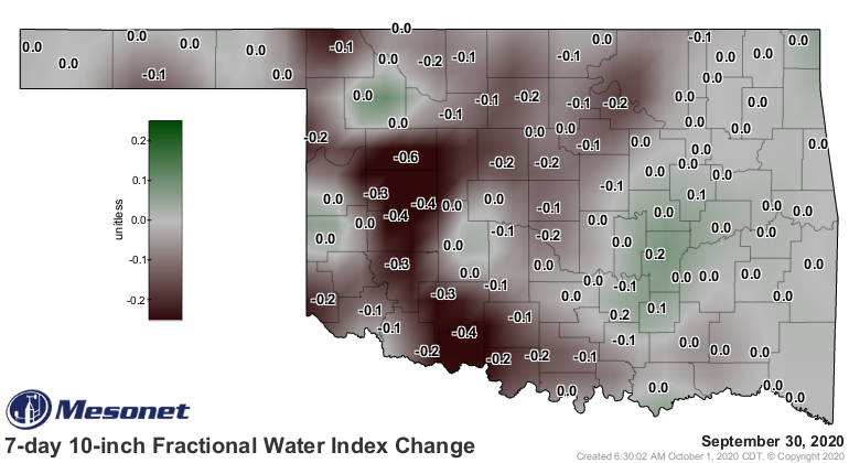
and hopefully taken advantage of rains earlier this month. Soil moisture is
starting to flag lately.
The good news is, even with La Nina on the prowl, the weather pattern can and
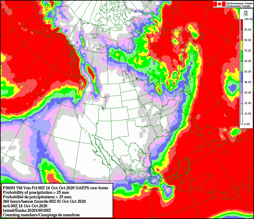
will change eventually. It's not looking good so far, though, and this
probabilistic forecast from a Canadian weather model shows just how precarious
things are looking...chances of seeing an accumulation of at least an inch of
rain through October 15 for most of Oklahoma. None.
That's echoed by the CPC 8-14 day outlooks.
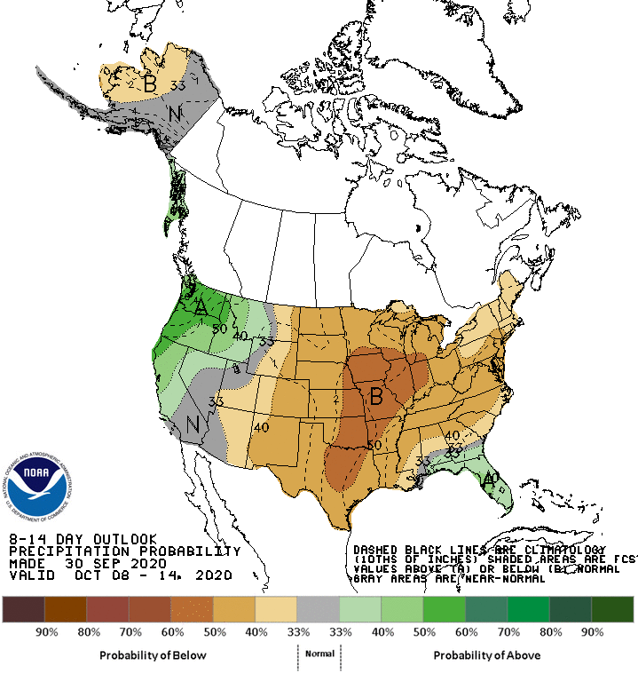
Not good. What is good is that the weather pattern will eventually change.
Something will start showing up at the end of those 7-day forecasts and then
it will morph into something even bigger and we'll all celebrate when that
happens. When that is, that's the question.
Now, onto the past.
---------------------------------------------------------------------------------
Winter Chill Stuns September
Oct. 1, 2020
A historic cold snap set the tone for a cool September, which saw one of the
earliest intrusions of winter weather in state history. An unusually strong
cold front blasted through the state September 8-9, sending temperatures
plummeting up to 50 degrees lower than the previous day’s highs. Lowest maximum
and minimum temperature records were shattered across the western half of the
state. High temperatures on the ninth struggled to a chilly 40 degrees at Boise
City and Kenton following lows of 33 degrees. Those maximum and minimum
temperatures were the lowest on record for that early in the fall season in
Oklahoma. To find the previous instance of the earliest high temperature of 40
degrees requires a journey back to 1945 when Boise City hit 40 on September 28,
a full 19 days later than the new September 2020 record. While wind chills
remained in the 20s and 30s across the northwestern quarter of the state, heat
index values soared close to 100 degrees in the far southeast, which missed out
on the early winter feel altogether. Temperatures moderated through the rest of
the month, failing to reach the depths of that early cold snap again. Severe
weather was almost non-existent during September, although a brush with
Tropical Storm Beta provided an unneeded dose of moisture to the far southeast
later in the month.
According to preliminary data from the Oklahoma Mesonet, the statewide average
temperature for the month was 69.9 degrees, 2.4 degrees below normal to rank as
the 13th coolest September since records began in 1895.
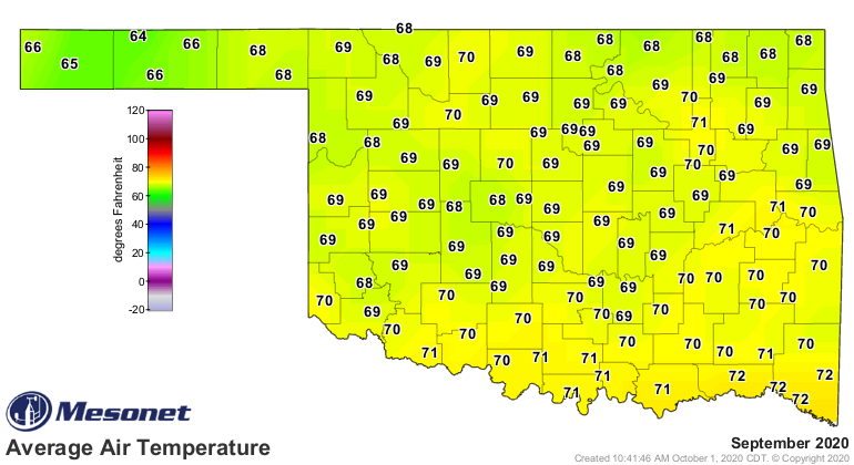
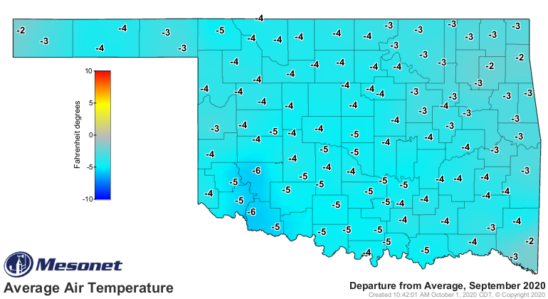
Summer weather was present, but certainly not common. Several stations reached
102 degrees on the 25th for the highest readings for the month, although the
120 Mesonet sites recorded only nine triple-digit temperatures for all of
September. It was a particularly cool month for south central and southwestern
Oklahoma. Both fell below normal by more than 3 degrees to rank as their eighth
coolest Septembers on record. The year-to-date statewide average was 64 degrees,
0.7 degrees above normal to rank as the 35th warmest January-September on
record.
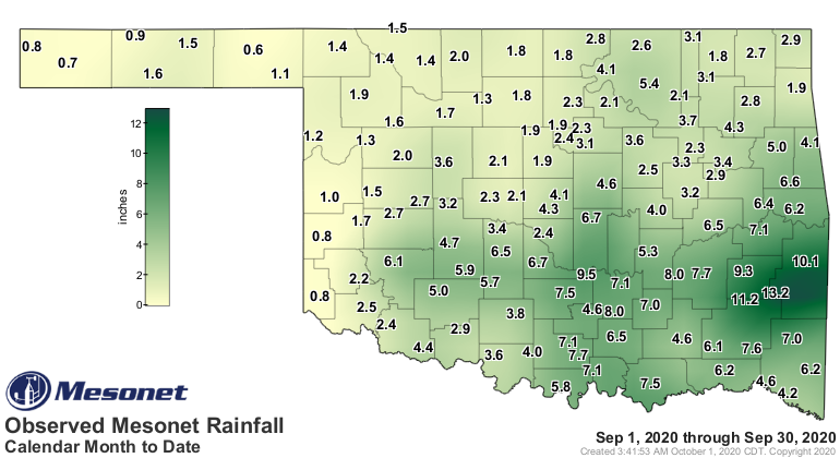
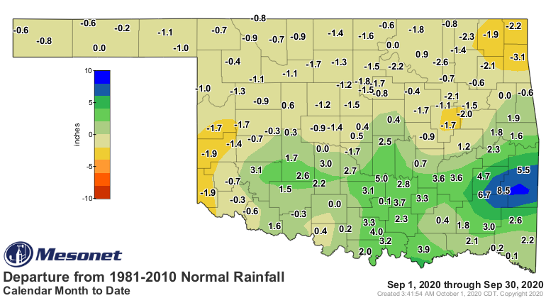
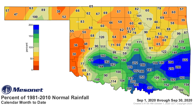
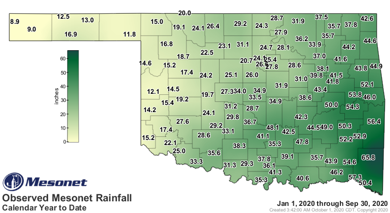
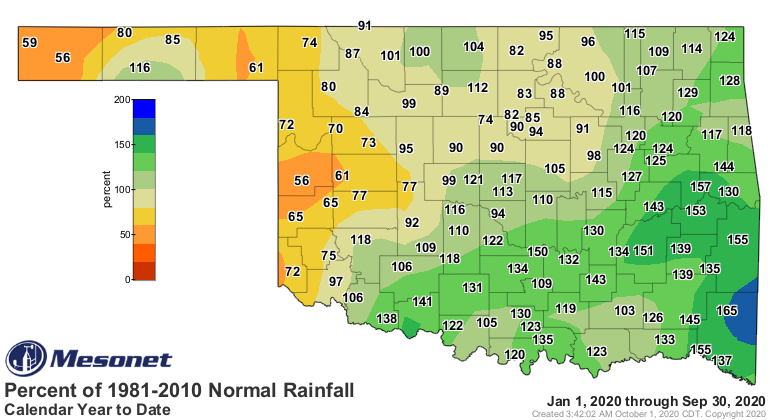
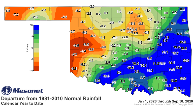
There was a tremendous difference in rainfall during the month between the
northern and southern halves of the state – save for the far southwest, which
took dry to another level. From Interstate 40 south, rainfall amounts ranged
from 2-5 inches above normal with localized larger totals. Totals north of I-40
fell 1-2 inches below normal. Overall, the September statewide average was 3.81
inches, 0.28 inches above normal and the 43rd wettest September on record.
Talihina led the month with 13.2 inches of rain, but 30 Mesonet sites had at
least 6 inches during September. The January-September average was 31.69 inches,
3.3 inches above normal to rank as the 24th wettest such period on record.
The cool weather helped preserve rains earlier in the summer and minimize
drought expansion, but there was also little in the way of drought improvement.
Adding to Oklahoma’s drought worries, below average sea surface temperatures in
the Equatorial Pacific could lead to more dry times through early 2021.
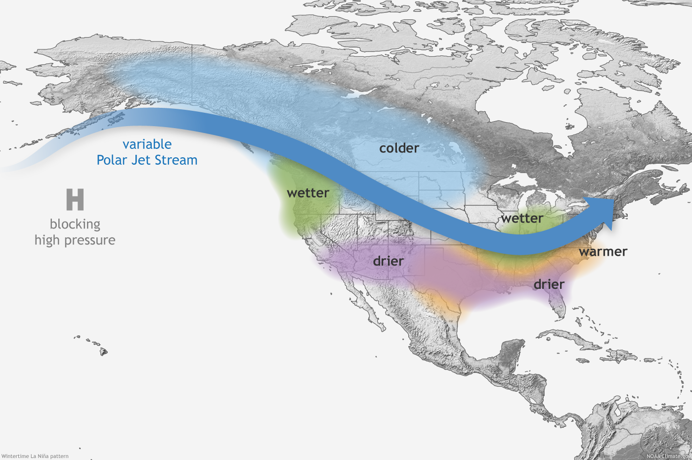
According to the Climate Prediction Center (CPC), La Niña conditions developed
during September and are likely to continue through the winter, prompting the
agency to issue a La Niña Advisory. This unhelpful El Niño counterpart can push
the jet stream farther to the north across the North American continent,
leaving the southern tier of the United States – including Oklahoma – warmer
and drier than normal during the cool season.
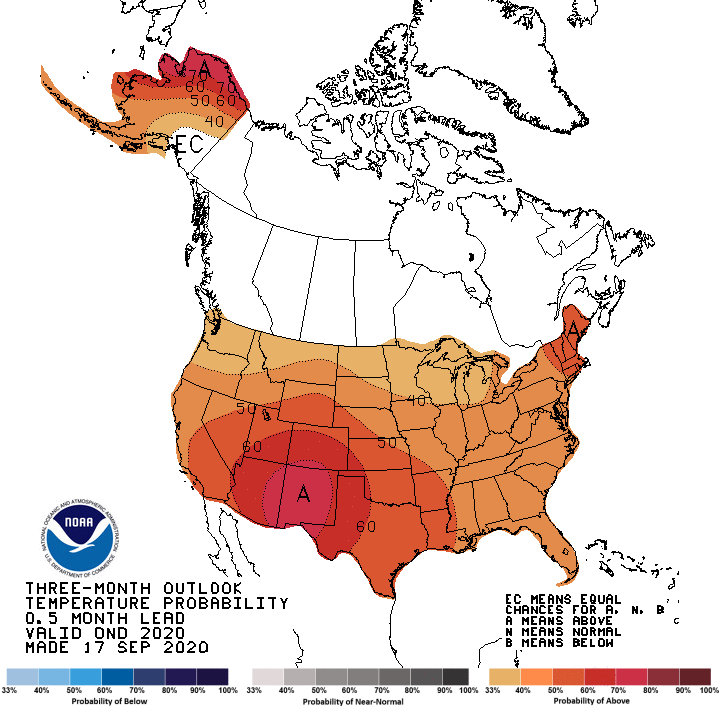
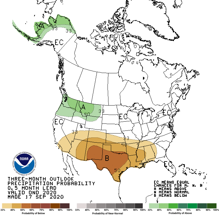
CPC’s October and October-December outlooks reflect La Niña’s influence with
increased odds of above normal temperatures and below normal precipitation.
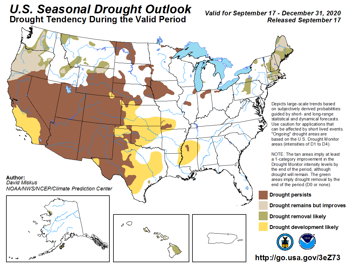
CPC’s October drought outlook indicates possible drought expansion across
western Oklahoma, while the October-December drought outlook shows that drought
expansion extending across nearly all of the state, save for the southeastern
corner.
Possible implications for the state due to La Niña include further
intensification of the current drought and an enhanced wildfire season. CPC
forecasters caution that each La Niña is different, and not all impacts occur
during every episode – their probabilities are increased, however.
Gary McManus
State Climatologist
Oklahoma Mesonet
Oklahoma Climatological Survey
(405) 325-2253
gmcmanus@mesonet.org
October 1 in Mesonet History
| Record | Value | Station | Year |
|---|---|---|---|
| Maximum Temperature | 99°F | SLAP | 2000 |
| Minimum Temperature | 34°F | KENT | 2009 |
| Maximum Rainfall | 3.52″ | ERIC | 1998 |
Mesonet records begin in 1994.
Search by Date
If you're a bit off, don't worry, because just like horseshoes, “almost” counts on the Ticker website!