Ticker for July 2, 2020
MESONET TICKER ... MESONET TICKER ... MESONET TICKER ... MESONET TICKER ...
July 2, 2020 July 2, 2020 July 2, 2020 July 2, 2020
Sweatshop
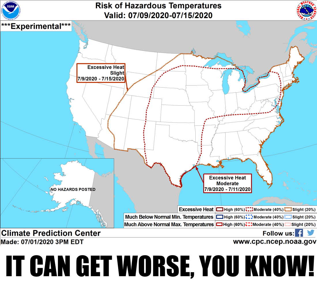
Oh boy, I haven't seen a worse image than that since I walked into a store and
the surveillance camera's view of the top of my head showed on the place's
security display. But only a crazy person would look to July for relief of
the summer heat. Our hottest month usually, this July is looking like a scorcher,
and that's not counting what we've seen just in its first day.

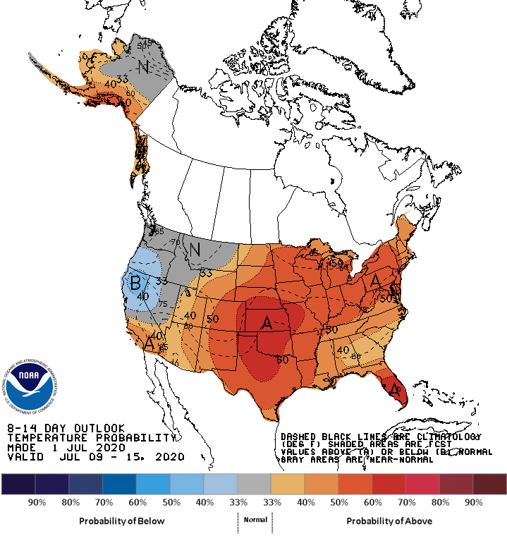
Yikes! And if you scroll down to our recap of June, you'll know this is not
good news for Oklahoma's ongoing drought situation. All signs point towards
more drought intensification and spread through the month. And the outlooks
for late next week into the next show that same signal.

Things aren't *all* bad, right? there will be a chance of rain on and off
over the next several days, and even with a chance of severe weather starting
tonight. And with any luck, some of that rain will target hard hit parts of
northern Oklahoma.
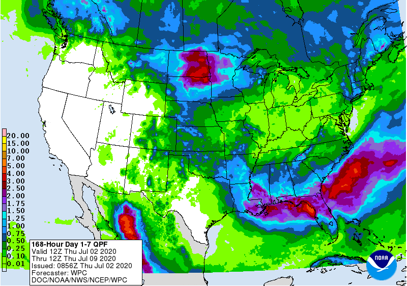
Make no mistake here, however. Those aren't drought-ending rains. Heck, those
would barely be drought-slow-down-just-a-tad rains. At this time of year, the
demand from evaporation, vegetation, and humanity is off the scale. It takes
some hefty precip to counteract that demand. As we've mentioned before, Sean
Connery was the best Bond. Also, a good tropical system would do wonders for
cutting this drought off at its knees.
We'll pause while you ponder James Bond portrayals, and also why the heck that
was thrown into the middle of a drought discussion. Yeah, we don't know either.
Enough talk. Back to June.
----------------------------------------------------------------------------------
June Rains Falter As Drought Surges
July 2, 2020
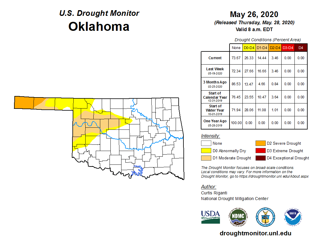
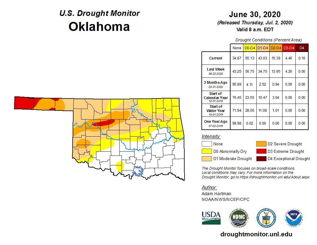
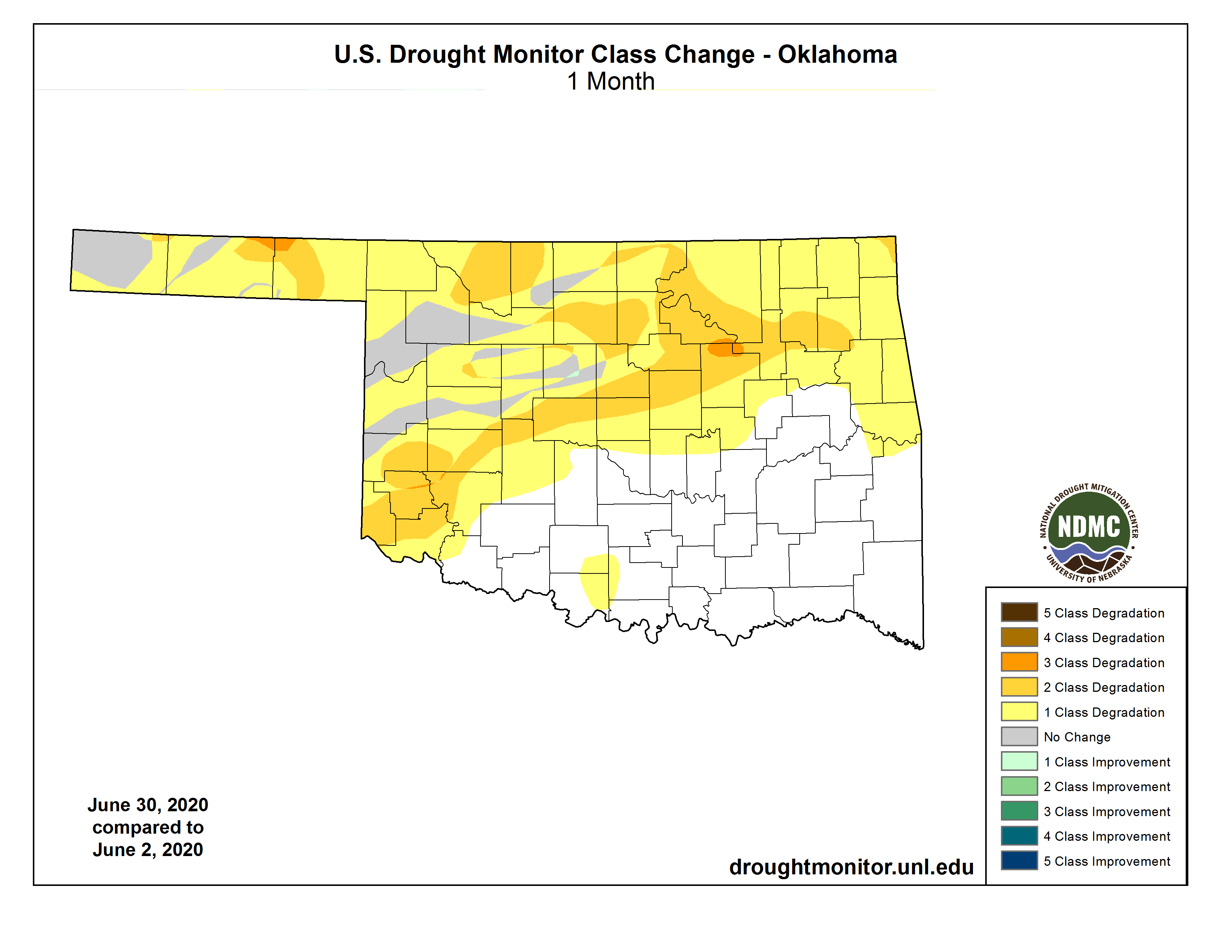
Largely deprived of its primary rainy season, Oklahoma saw drought surge across
the state during June. A mid-month bout with showers and storms managed to stem
the flash drought’s intensification and spread with beneficial rains across
northwestern Oklahoma. The respite was brief, however. Dry weather and intense
heat returned by the end of the month and drought was again on the move to the
south and east. Contained wholly within the western half of the state at the
end of May, drought had progressed to the state’s eastern border by the end of
June. Drought coverage leapt from 14% of the state to 43% over that same period
according to the U.S. Drought Monitor. That was the highest coverage of drought
Oklahoma had seen since Aug. 14, 2018. Much of the western Panhandle was
covered by extreme drought, and exceptional drought bled down from Kansas and
Colorado into far northern Cimarron and Texas counties. The Drought Monitor’s
intensity scale slides from moderate-severe-extreme-exceptional, with
exceptional being the worst classification.
Normally the wettest part of the year in Oklahoma, the mid-May through mid-June
period was dominated by a large dome of high pressure over the Southern Plains
that limited chances for significant moisture. The mid-month storm system
managed to partially salvage the primary spring rainy season for Oklahoma, but
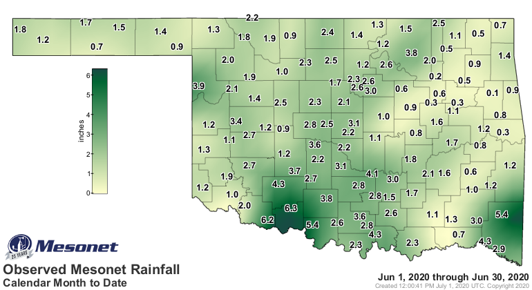
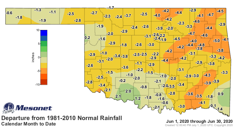
significant deficits remained following its exit. According to preliminary data
from the Oklahoma Mesonet, the statewide average rainfall total was 1.97 inches,
2.55 inches below normal and ranked as the 15th driest June since records began
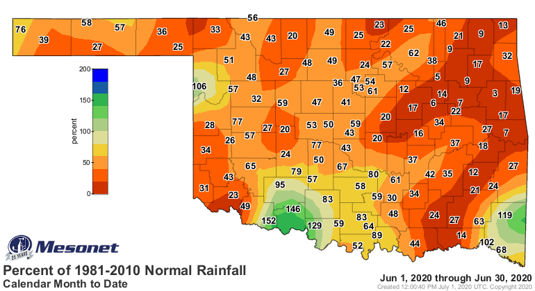
in 1895. Most of the state ended with deficits of 1-3 inches, with the lowest
totals being reported across eastern Oklahoma. Deficits there reached 5 inches
in some locations and amounted to less than 10 percent of their normal June
rainfall. The Mesonet site at Walters led the reports with 6.32 inches, one of
only four Mesonet stations out of 120 to receive at least 5 inches of rain.
Sixty-seven sites recorded less than 2 inches for the month. Tulsa had the
state's lowest total at 0.11 inches, its driest June since local records began
in 1893.
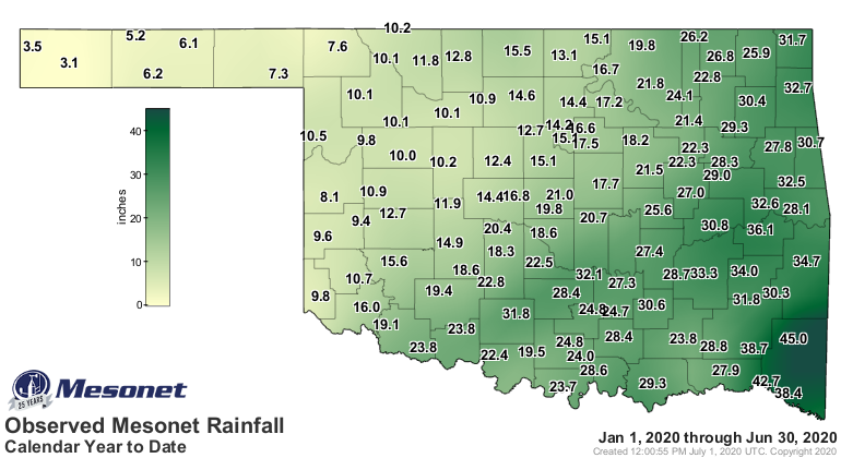
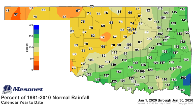
The January-June precipitation total of 20.1 inches was 1.07 inches above
normal to rank as the 33rd wettest on record, but rainfall varied wildly from
one region to the next. Deficits across the northwestern half of the state
ranged from 2-6 inches while the southeastern half saw surpluses balloon to
nearly 17 inches above normal.

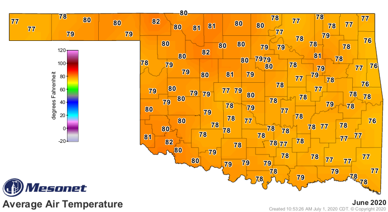
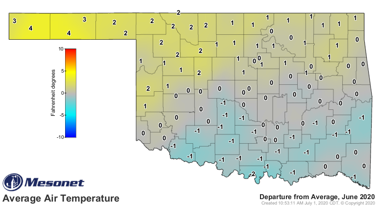
June’s weather was scorching hot during the first half of the month, and ended
much the same. Sandwiched in between was a 10-day period of pleasantly cooler
than normal weather, a fringe benefit of the mid-month storm system that
brought moisture to the state. Altogether, the statewide average of 78.5
degrees was 2 degrees above normal to rank as the 32nd warmest June on record.
The top reading in the state was 109 degrees at Altus and Erick on June 30, and
the lowest was a chilly 40 degrees from both Eva and Kenton on June 10. The
mid-month moisture made for sultry conditions when the heat returned to end the
month. The heat index soared as high as 113 degrees at several locations on
June 30. The Mesonet’s 120 stations reported a heat index of at least 105
degrees 191 times during the month. The warm June continued a pattern for 2020.
The January-June statewide average of 57.2 degrees was 1.5 degrees above normal
to rank as the 16th warmest such period on record.
Drought development across the remainder of Oklahoma – save for the southeast
quarter – is considered "likely" according to the Climate Prediction Center’s
(CPC) drought outlook for July. The existing drought across the northwestern
third of the state is expected to persist and possibly intensify. CPC’s
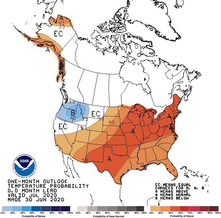
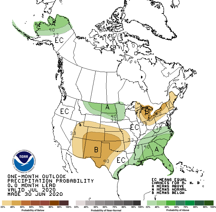
negative stance is a result of equally unpleasant July outlooks for
precipitation and temperature that indicate increased odds for above normal
temperatures and below normal precipitation across Oklahoma. The odds for
below normal precipitation are enhanced across much of western and central
Oklahoma.

Gary McManus
State Climatologist
Oklahoma Mesonet
Oklahoma Climatological Survey
(405) 325-2253
gmcmanus@mesonet.org
July 2 in Mesonet History
| Record | Value | Station | Year |
|---|---|---|---|
| Maximum Temperature | 107°F | KIN2 | 2024 |
| Minimum Temperature | 49°F | SEIL | 2013 |
| Maximum Rainfall | 6.98″ | FITT | 2017 |
Mesonet records begin in 1994.
Search by Date
If you're a bit off, don't worry, because just like horseshoes, “almost” counts on the Ticker website!