Ticker for June 18, 2020
MESONET TICKER ... MESONET TICKER ... MESONET TICKER ... MESONET TICKER ...
June 18, 2020 June 18, 2020 June 18, 2020 June 18, 2020
Drought explosion
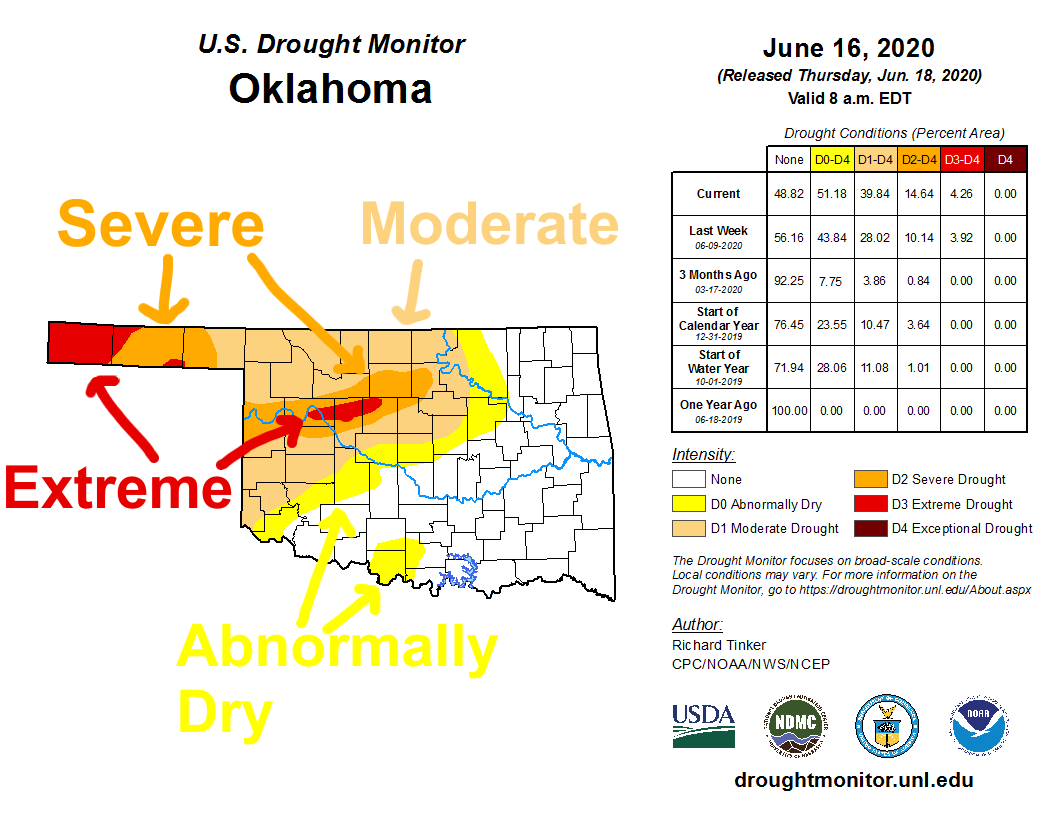
Oklahoma is currently in the throes of a rapidly expanding and intensifying
drought, originating in both the far western Panhandle and areas centered on
the Dewey/Blaine/Kingfisher counties area. We have long-term drought in the far
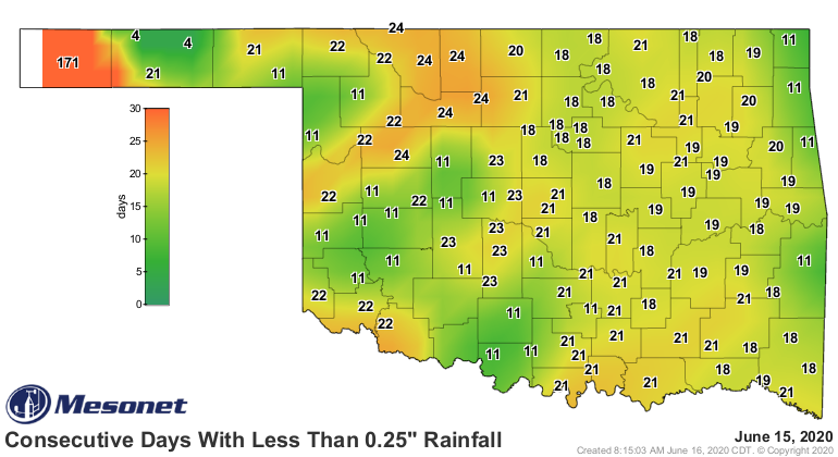
western Panhandle that has been persisting since the middle of last fall. It has
now been 173 days since Boise City has received a significant one-day rainfall
event, and has received a mere 2.4 inches of rain since last October 1.
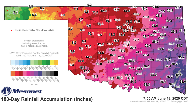
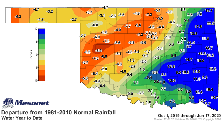
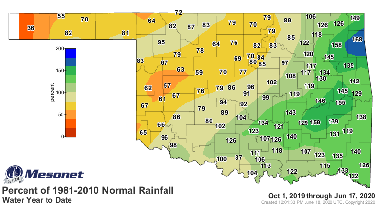
Those deficits of over 6 inches amount to just over 30% of normal over that time
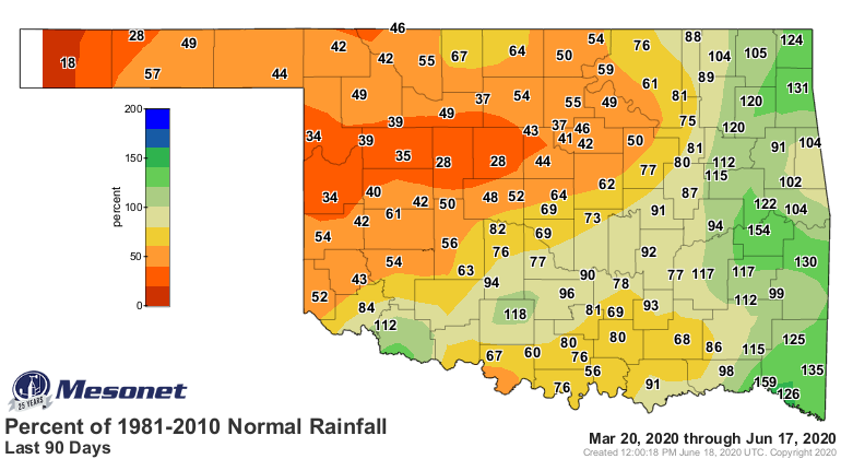
frame. The deficits there across SW through NC Oklahoma are significant as well,
but the majority of those deficits has occurred in the last 90 days, as we
referenced yesterday.

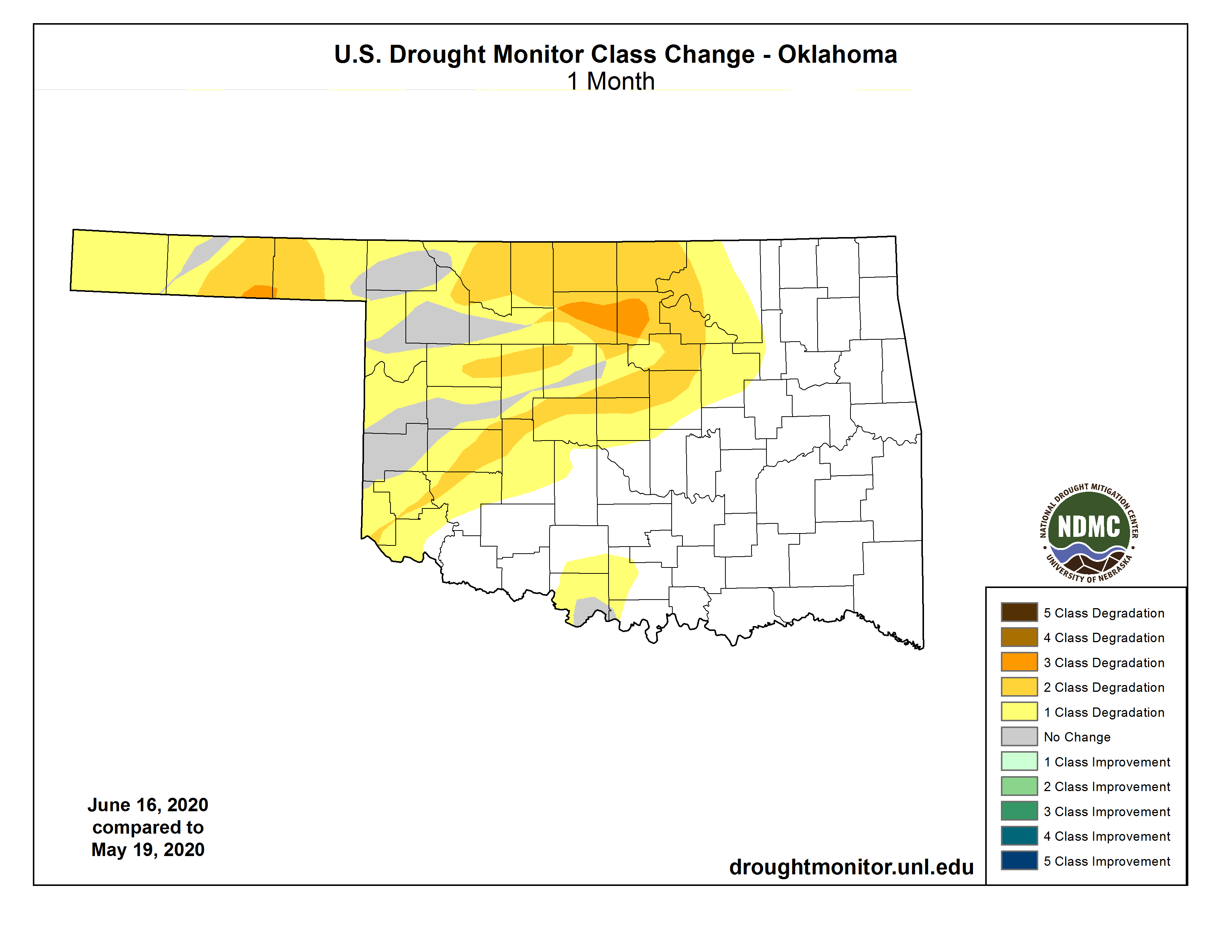
That then becomes the core of the flash drought area, which has seen a 2-3
category drought intensification in the last 4 weeks.
Many of those areas from the OK/TX border area in west central OK through
central OK have seen record low rain amounts since April 1.
-***-
Rain since Apr. 1 Previous Record Low
Arnett 2.3" 2.42" (2011)
Watonga 2.2" 2.77" (1933)
Kingfisher 2.6" 3.23" (1933)
-****-
It's bad enough to be hanging out in 2011 territory and beating those records,
but to go back to the 1930s and beat Dust Bowl records is catastrophic. Now I
did promise you a few Tickers back a comparison between the beginnings of our
historic 2010-15 drought and this year's, since we had been hearing some rather
unfair comparisons of the heat. I'm not going to dwell on it, since I'm champing
(I sez "champ," you say "chomp") at the bit to get to our exciting rainfall
outlook. Just as with the heat, our current drought can't really compete with
2011 (really 2010-11, as this one is also 2019-20). Exacerbated by the
aforementioned historic heat of 2011, the drought at this point back then was
already some of the worst the state had seen since the 1950s, and in some case
the Dust Bowl days of the Dirty Thirties.

By this time in 2011, over 10% of the state was covered by Exceptional drought
(D4), the worst DM category, as compared to zero this year. And nearly 34%
was in at least Extreme drought, compared to 4% this year. And by this time
back then we had seen horrendous dust and sand storms across the western half
of the state, and one of the worst wheat crops in state history. So no
comparison, really. And here was that drought one week later (play ominous
"Jaws" music here..."The Shining" will work, too).
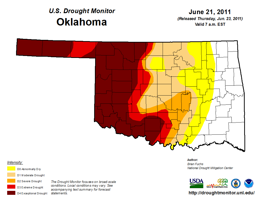
BOOM! It only got worse from there.
Another way it can't compare is our upcoming rain chances...something that was
always "hopefully in another week" in 2011. Check out this 5-day rainfall
forecast map.
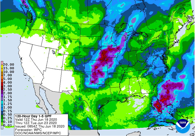
Now ain't that a (possible) beautiful sight? I say "possible" because it
actually has to happen, but it does appear we will see some beneficial rainfall
beginning tonight into early next week. It might not end up being a drought
buster, but at this point we need to interrupt the evolution of this drought
and at least delay it, or knock it down a peg or two. Then we have hopes that
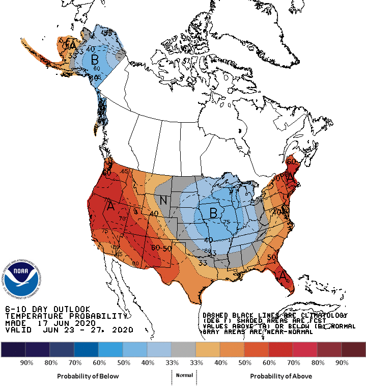
this pattern change will last later into next week, with below normal temps
and above normal rainfall, as evident in the CPC 6-10 day outlooks.

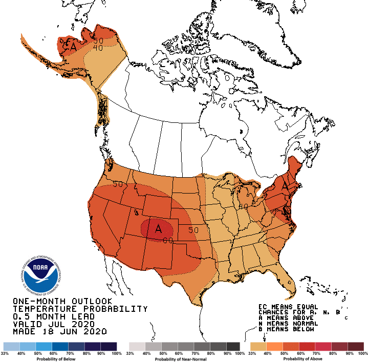
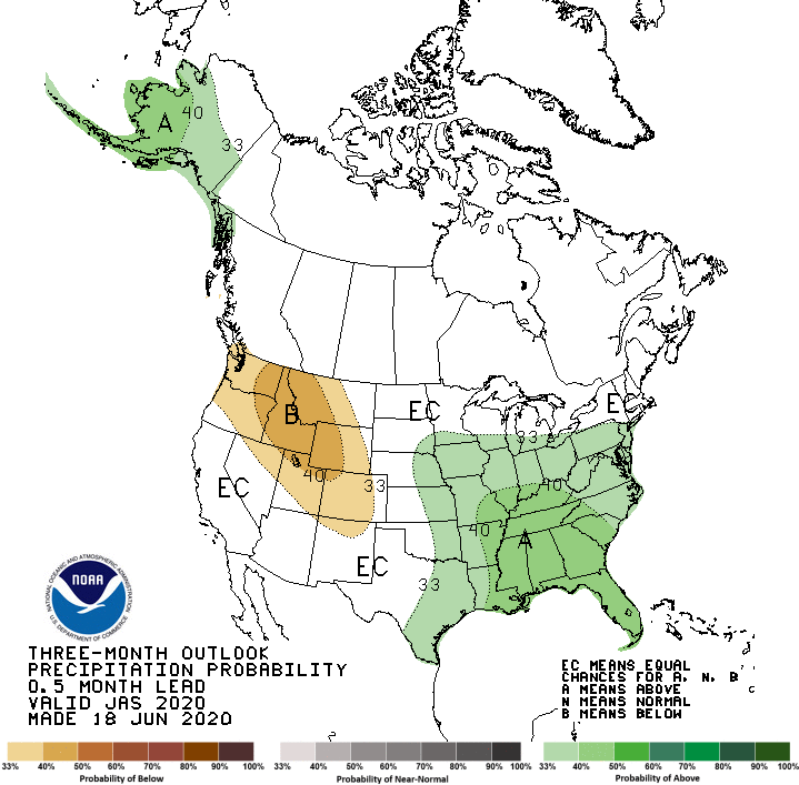
How about farther out? Well, we don't see anything pointing towards wet weather
through summer, save for eastern Oklahoma (sorry guys), but we don't see any
hints of drier weather either. We do see chances for some big heat.
July
----
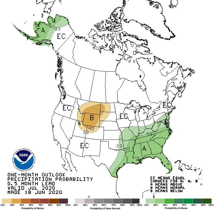
July-September
--------------

That heat would not be good for drought concerns, of course. That's a long way
away as well, so we are involuntary participants in an uncontrolled forecast
verification program on those outlooks. In other words, we'll see. Our hopes for
now are pinned to the next seven days or so, then we can worry about the next
11 weeks after that.
Gary McManus
State Climatologist
Oklahoma Mesonet
Oklahoma Climatological Survey
(405) 325-2253
gmcmanus@mesonet.org
June 18 in Mesonet History
| Record | Value | Station | Year |
|---|---|---|---|
| Maximum Temperature | 110°F | GRA2 | 2011 |
| Minimum Temperature | 42°F | KENT | 1998 |
| Maximum Rainfall | 5.74 inches | HOOK | 2024 |
Mesonet records begin in 1994.
Search by Date
If you're a bit off, don't worry, because just like horseshoes, “almost” counts on the Ticker website!