Ticker for June 15, 2020
MESONET TICKER ... MESONET TICKER ... MESONET TICKER ... MESONET TICKER ...
June 15, 2020 June 15, 2020 June 15, 2020 June 15, 2020
Don't call it a comeback!
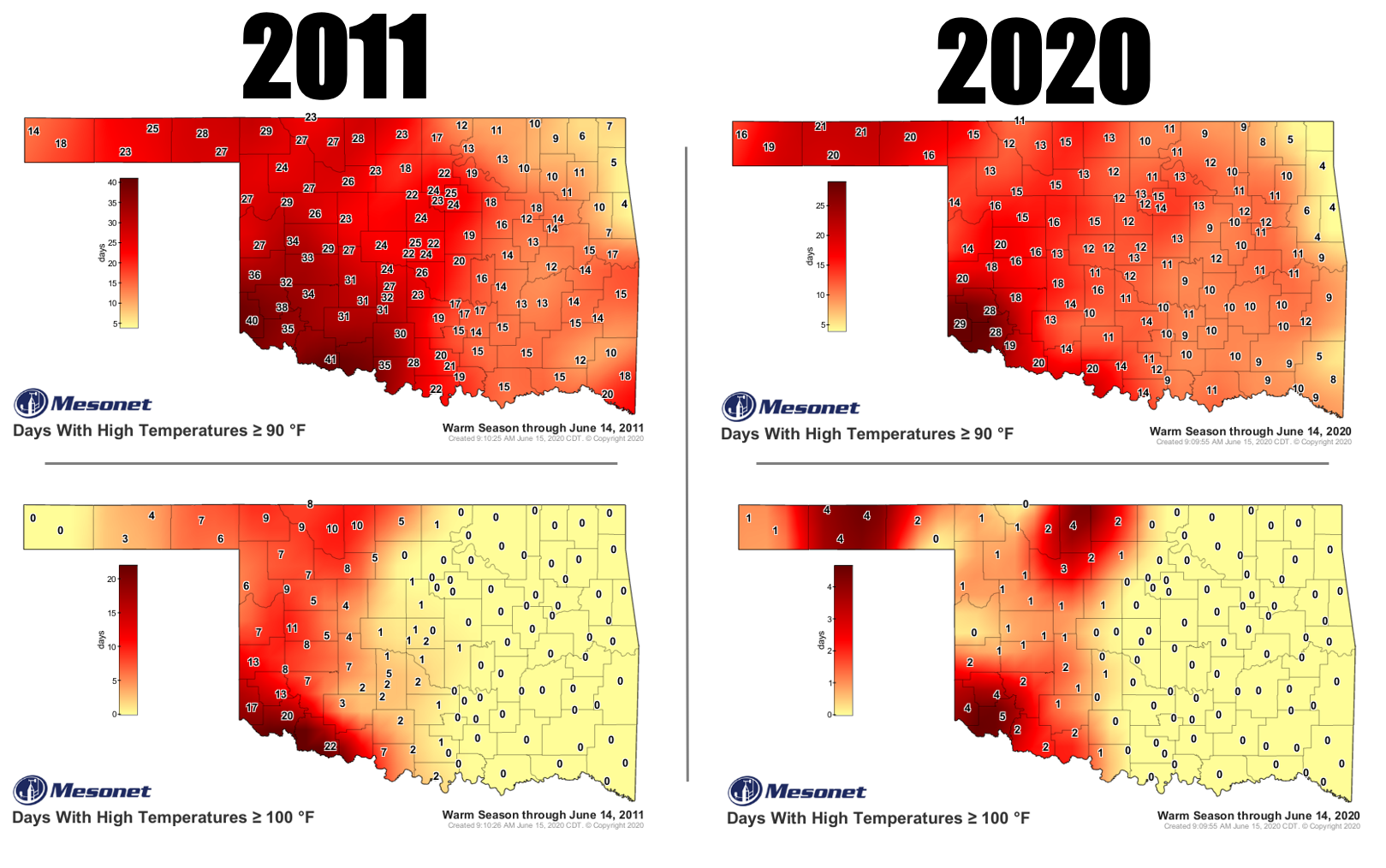
I keep hearing folks compare the summer of 2020 to 2011.
I lived through the summer of 2011. I knew the summer of 2011. The summer of 2011
was a friend of mine. 2020, you're no 2011.
I'm sorry if that was uncalled for, but I can at least understand how this would
seem like 2011, with the intersection of some pretty decent heat and an
intensifying flash drought spreading from northwestern Oklahoma to the southeast.
But let's hearken back (which is much less painful than having a back hearken)
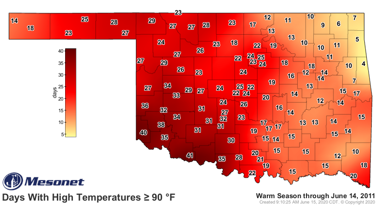
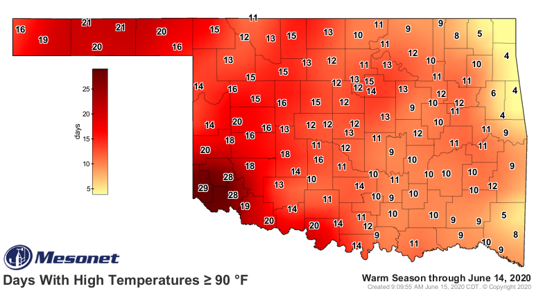
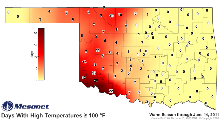
to what was going on in 2011. By this time in June in 2011, southwestern Oklahoma
had already seen 35-40 days with highs above 90 degrees, and much of western OK
had 10-20+ days at or above 100 degrees. For 2020, we're talking about half of
the days with 90 degrees numbers, and a quarter of that for the century mark.
Here are the comparisons again:
Temps GE 90 degrees
-------------------
Temps GE 100 degrees
--------------------
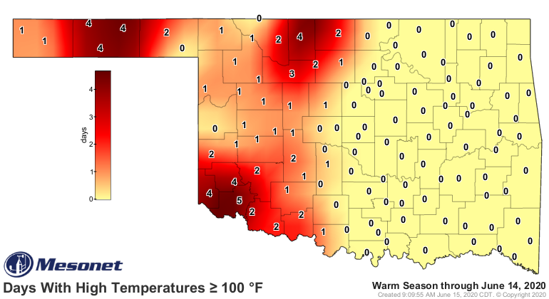
And for those that had the extreme heat back in 2011, it's not even close. Let's
concentrate on Altus and see the comparisons between 2011 and 2020.
Days above 90
-------------
2011: 35
2020: 20
Days above 100
--------------
2011: 20
2020: 5
So the heat is somewhat similar, at least with the above 90 degrees mark, but
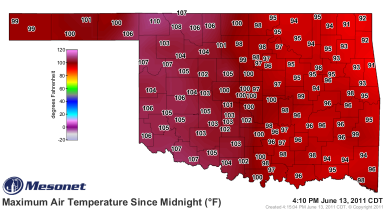
the extreme heat? Come on now. Take a look at the June 13, 2011, high
temperature map, representative of what we were seeing almost daily back then,
and then compare it to what we're seeing now.
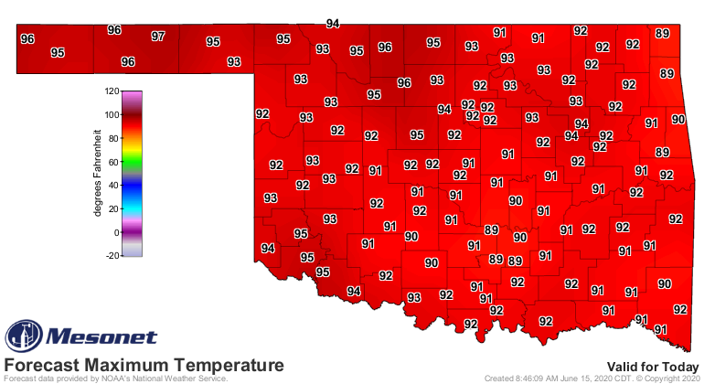
Again, that's not to say this June is slacking in the heat department. So far,
through June 14, temperatures are running about 5 degrees above normal
statewide. Average high temps are about 92 degrees, close to 6 degrees above
normal. Compare that to 2011 through that same period...again, not even close.
-***-
Avg. Highs Avg. Lows Avg. Temps
2011 95.4F 69.9F 82.7F
2020 91.7F 64.7F 78.2F
Normal 85.6F 63.4F 74.5F
-****-
Simply put, June 2011 was one of the worst months in Oklahoma history
heat/drought wise (and we'll compare the drought situations later this week).
And it only got worse from there (June 14). June 2011 ended as the third
warmest June on record with a statewide average of 83.4 degrees, and average
highs were 96.8 degrees.
I don't believe we're headed there just yet. The 2011 heat was a special
combination of heat/drought that fed off of each other, eventually giving us the
hottest climatological summer (June-August) on record for any state since
records began in 1895. We actually tied with Texas, but the two states blew
the previous record out of the water.
Oklahoma's statewide highs AVERAGED 100.4 degrees that summer. We're not there
yet. There's still too much soil moisture over half of the state to evaporate
before the sun's energy goes primarily towards heating the surface, transforming
our landscape into the gigantic Easy Bake Oven that we saw back in 2011.
We're not seeing anything like this yet.
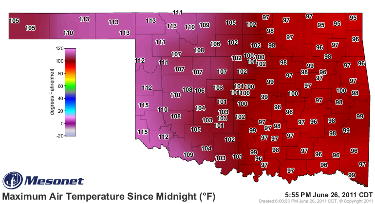
Yet.
Gary McManus
State Climatologist
Oklahoma Mesonet
Oklahoma Climatological Survey
(405) 325-2253
gmcmanus@mesonet.org
June 15 in Mesonet History
| Record | Value | Station | Year |
|---|---|---|---|
| Maximum Temperature | 104°F | ALTU | 2022 |
| Minimum Temperature | 42°F | KENT | 2001 |
| Maximum Rainfall | 5.22 inches | BYAR | 2007 |
Mesonet records begin in 1994.
Search by Date
If you're a bit off, don't worry, because just like horseshoes, “almost” counts on the Ticker website!