Ticker for May 14, 2020
MESONET TICKER ... MESONET TICKER ... MESONET TICKER ... MESONET TICKER ...
May 14, 2020 May 14, 2020 May 14, 2020 May 14, 2020
Weather madness
Well THAT was interesting. In the midst of Oklahoma's somewhat tame by our
standards severe weather event last night, we had a couple of oddities. First we
had a pretty good heatburst travel through central Oklahoma last night from
about OKC to the northeast towards Bristow. Now that's not the exact location, but
that seems to be where our Mesonet sites picked it up. The heatburst bursted
best (say it 5 times fast: "it it it it it"...that wasn't tough at all!) near
Chandler as a dying storm decided to gust out, kicking winds up to 65 mph and
seeing temperatures rise from 68 degrees at 4:40am to a peak of 82 degrees at
5:55am. You can check it out for yourself on this here meteogram from Chandler,
which we've marked up with our crayons.
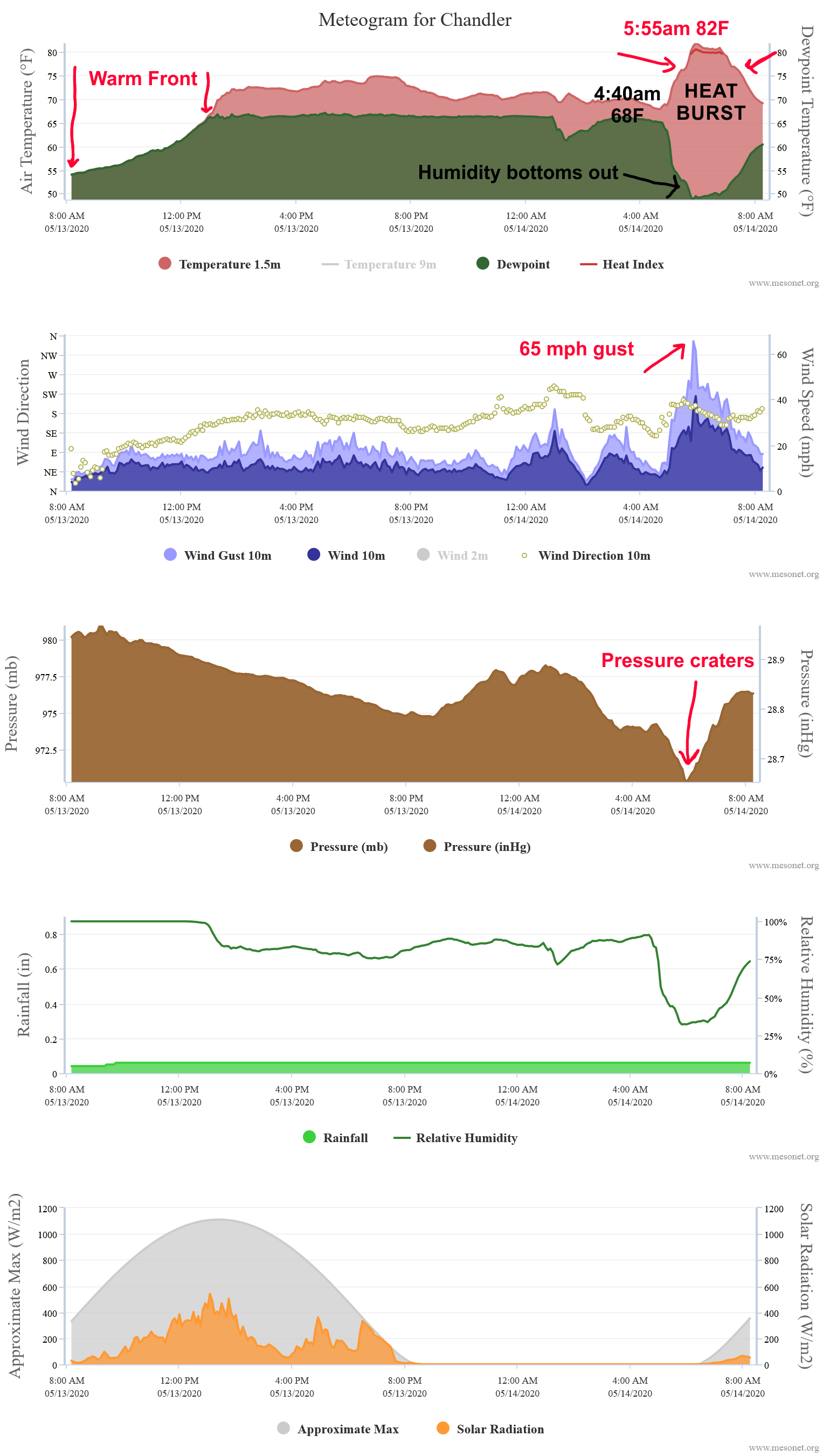
For a very rudimentary explanation, a dying storm dumps its
evaporation-cooled air to the surface where it compresses and warms (i.e.,
the hair drier effect ... or in my case, a scalp drier). By Oklahoma standards,
this was a tame heatburst. We've had many more impressive ones, topped by the
granddaddy of them all, the May 22-23, 1996, heat burst in SW OK that saw winds
top out at Tipton at 105 mph. You can check out more on that event, and heatbursts
themselves, with an article written by some fool of a Took in our Summer 2006
Seasonal Summary.
http://climate.ok.gov/summaries/seasonal/Oklahoma_Climate_Summer_2006.pdf
Even more interesting to me was the mini-hurricane we saw near Minco last night.
Winds at Minco gusted to over 50 mph for two straight hours this morning
between 2:30am and 4:35am, topping out at 77 mph at 4:10am.
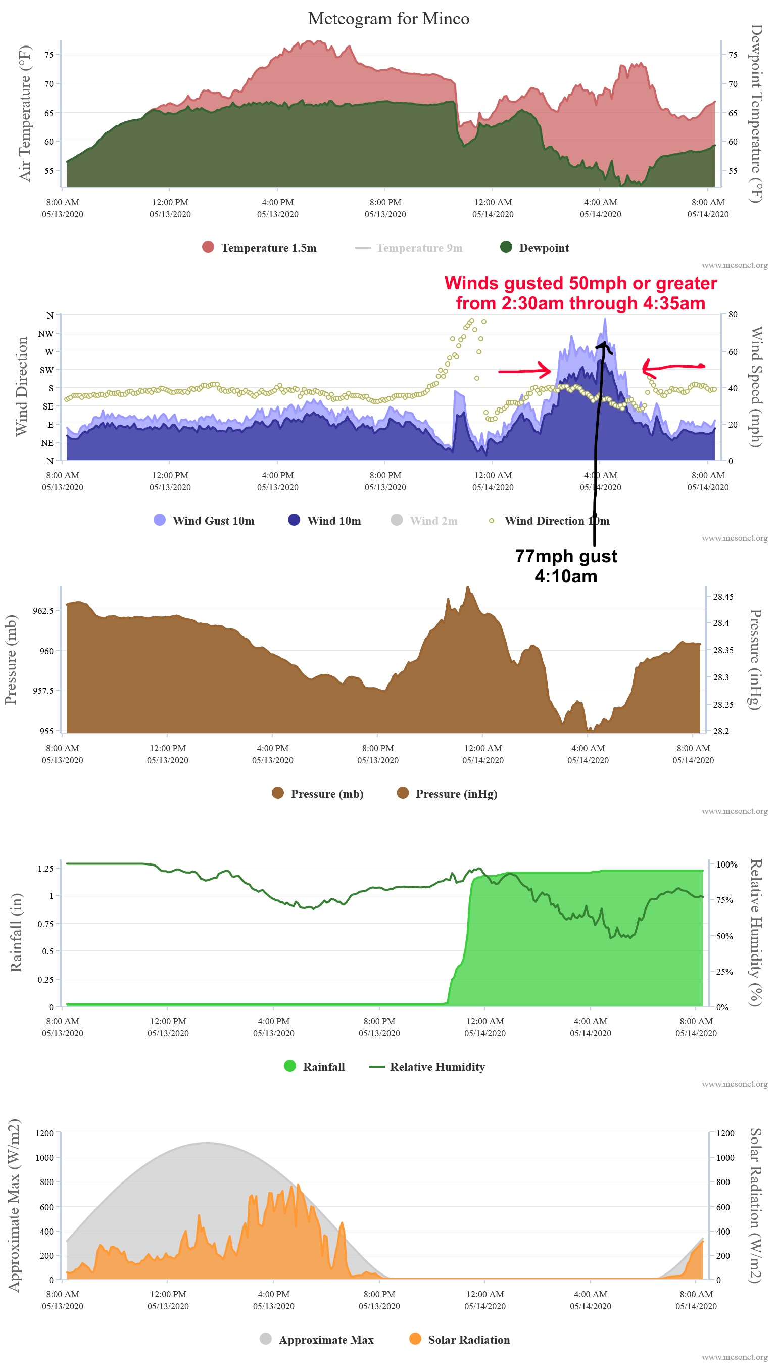
I haven't had time to go through the data completely, but I believe this was
associated with a meso-low pressure system that moved over the area, with
Minco being stuck in its upper-left quadrant for a couple of hours. Or it could
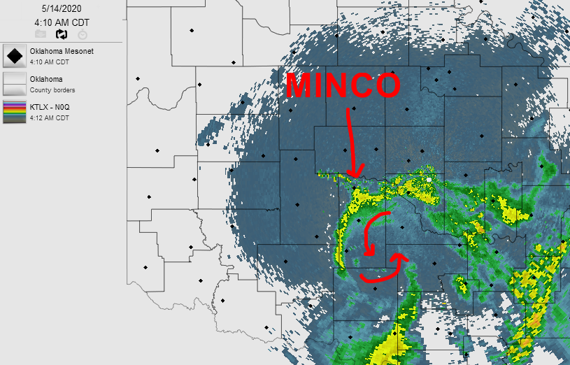
have been a mini heatburst event, or a combination of both. There appears to be
a meso-low signature on the radar just about that time frame. You can see the
signature on this radar image from 4:10am with the characteristic cyclonic
"doughnut hole" just to the southeast of Minco.
Sustained winds at Minco were over 40mph that entire time as well, topping out
with a 5-minute average wind speed of 55 mph at 4am.
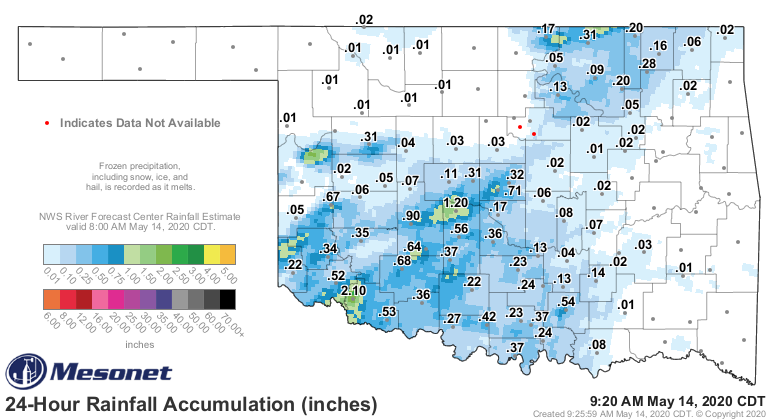
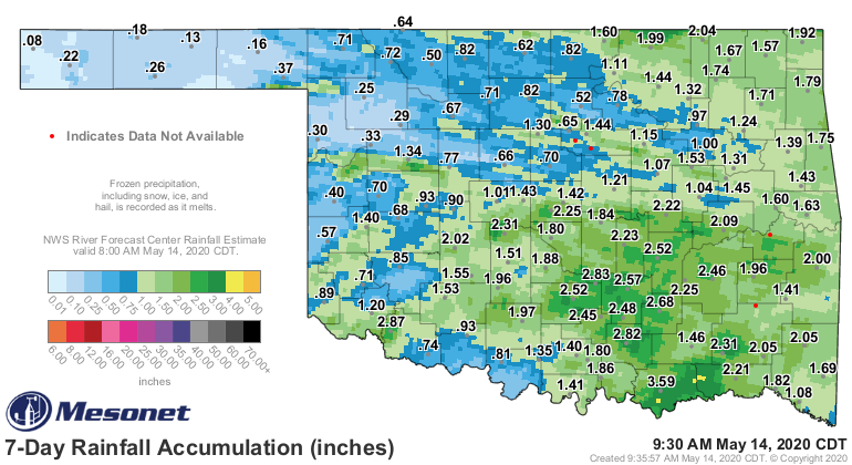
Okay, now onto more boring stuff. In addition to the hail and severe winds,
we did get some rain with the storms. Mostly spotty amounts of an inch or
greater. Tipton came in the winner with 2.1 inches, and Minco managed to get
1.2 inches during its imitation of the tropics.
We also had some big misses, however, hurting folks that really needed some
moisture. You can see from the latest U.S. Drought Monitor report hot off the
presses this morning that the Panhandle and far NW OK could have used another
good dose.
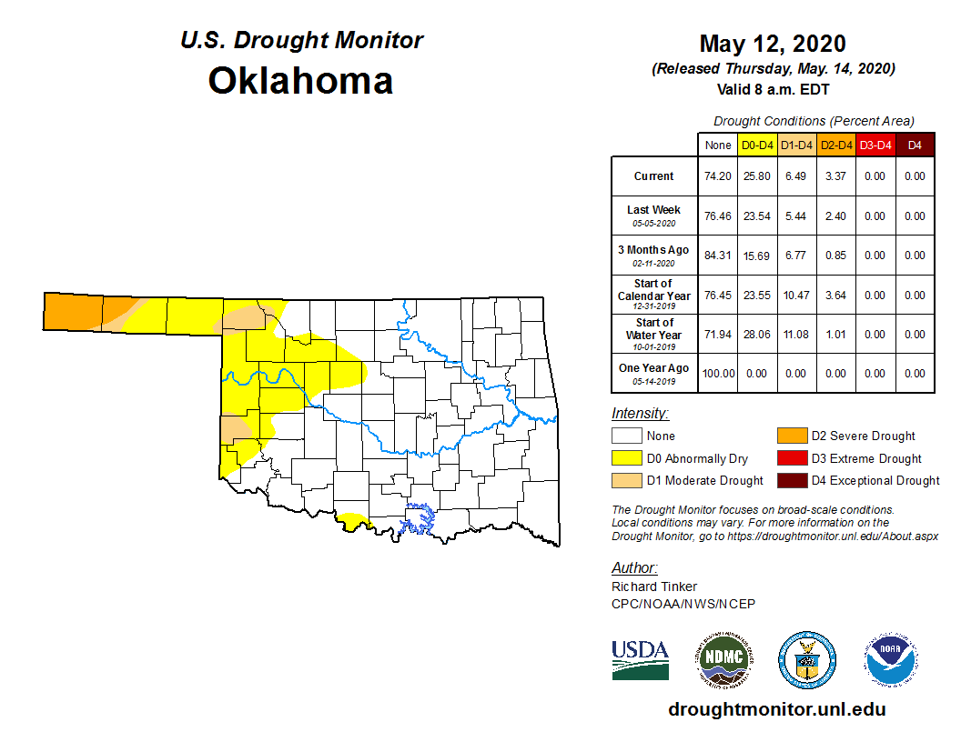
That area from Roger Mills and Ellis counties to the east towards Blaine, Logan
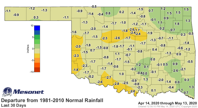
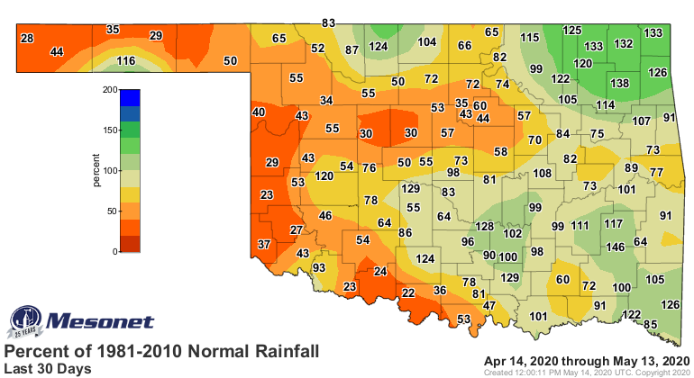
and Kingfisher counties is particularly troubling. Some rains have targeted
that part of the state over the last week, but deficits there continue to
grow over the last 30+ days. Much of western Oklahoma into central Oklahoma
is in the same boat. Yeah yeah, we see you Minco. Don't show off.

We will see chances of rain and storms over the next few days, but after that
we dry out for the weekend and the temperatures shoot back up into the 70s and
80s. Prospects aren't great for western Oklahoma, but they're not dismal
either.
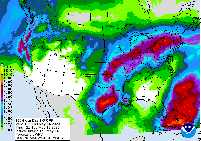
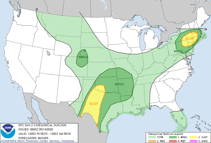
Stay weather aware for the next couple of days, especially on Friday. Severe
weather will be on the rise again.
Gary McManus
State Climatologist
Oklahoma Mesonet
Oklahoma Climatological Survey
(405) 325-2253
gmcmanus@mesonet.org
May 14 in Mesonet History
| Record | Value | Station | Year |
|---|---|---|---|
| Maximum Temperature | 99°F | ALV2 | 2018 |
| Minimum Temperature | 30°F | HOOK | 2004 |
| Maximum Rainfall | 3.44 inches | CLOU | 2003 |
Mesonet records begin in 1994.
Search by Date
If you're a bit off, don't worry, because just like horseshoes, “almost” counts on the Ticker website!