Ticker for March 5, 2020
MESONET TICKER ... MESONET TICKER ... MESONET TICKER ... MESONET TICKER ...
March 5, 2020 March 5, 2020 March 5, 2020 March 5, 2020
Drought watch
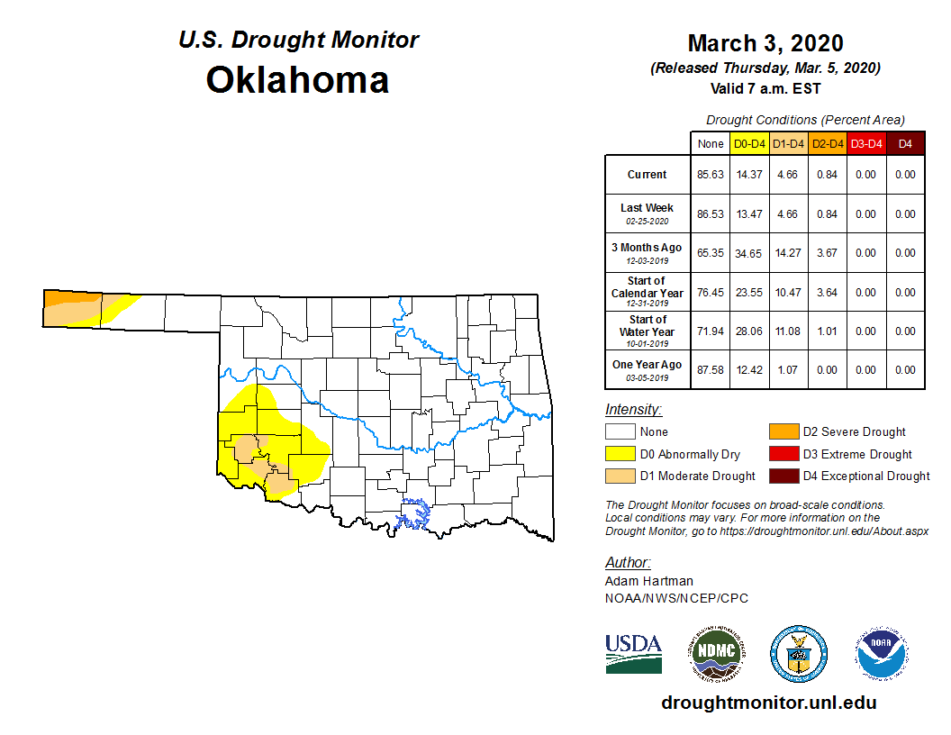
Yep, it's that time of year again. No no no, not when you slather pollen on your
scalp and hope honeybees will come and miracle you some new hair. That's just
what *I* do. No, hasn't worked yet. But for the rest of you, it's that time of
year when the temperatures start to climb and the plants start to awaken from
their winter dormancy. I think we could all agree that we're a couple weeks ahead
of that vegetative alarm clock due to the warm winter we had. Well, everybody
but Dave, but he's always disagreeable. What that means is that more pressure is
going to be put on our available moisture as the sun continues to climb, the
wind continues to blow, and the plants demand a bigger drink. Altogether, that
equals what's called "evapotransipiration." The evapo is for evaporation (sun and
wind), and the transpiration is for, uhhhhh, transpiration (plant demand).
It's not like we're starting off on a bad foot with our soil moisture. The
Mesonet's Plant Available Water maps show a good top- and sub-soil moisture
supply over much of the state.
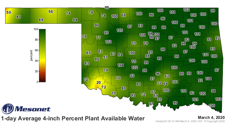
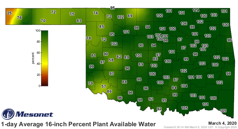

These maps show the water available to plants vs. the theoretical maximum amount
possible. Just a few places are approaching the stress category, and those
are obviously across western Oklahoma. So we're starting spring off on sort
of a good note. Sort of because we are definitely starting to dry out. Now
that's not necessarily a bad thing IF you can get it to start raining again
sometime soon. These dry days allow ag producers to get out and work the fields.
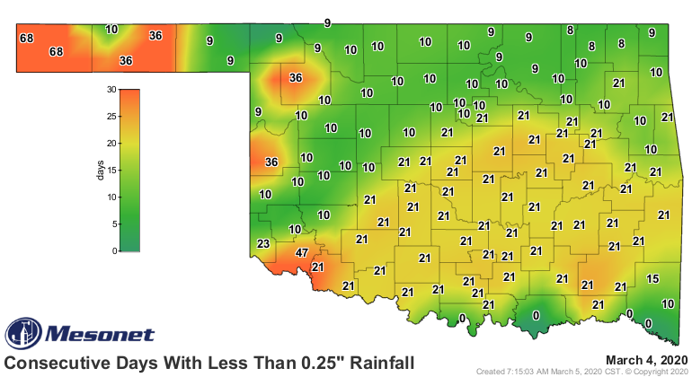
Hard to disc or fertilize if you're stuck in the mud. The consecutive days
without rainfall maps from the Mesonet show that much of southwest through
central Oklahoma (and beyond) are missing out on significant rains on any
given day. And the Panhandle is really starting to lag.

Now here's the conundrum (Okie translation: "there's fixing to be a problem").
When we look at the last 30 days, there are definitely deficits. Say that 3
times fast. But when you look out to 60 days, other than the far western
Panhandle, not so bad. Then it dries out a bit more across the SW quarter at
90 days, then a bit more as you get to 120 days.

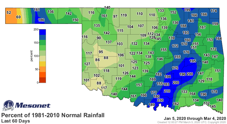


So other than the last 30+ days or so, we're not in too bad of shape. At least
in my 20 years or so of tracking drought in Oklahoma, we've seen much worse
going into spring.
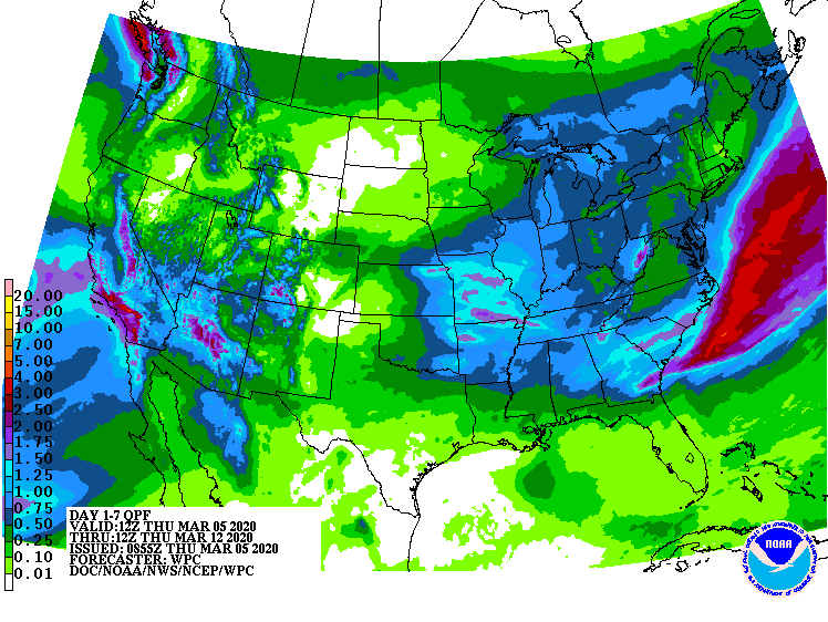
How about coming up for the next week? Well, there will be a chance of rain,
but not as great across western Oklahoma. Maybe up to a half-inch as we get
later into the weekend.
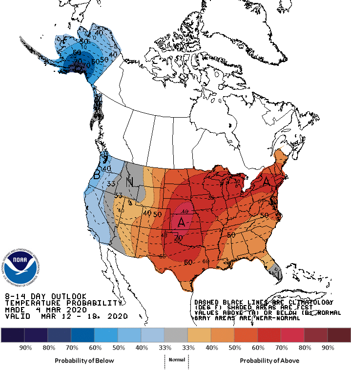
One of the factors that will add pressure, however, is we will stay above
normal on the temperature scale for the next couple of weeks, and maybe after
that as well.
As I noted in the last Ticker, it can still get REALLY cold as we go through
March into the first half of April. But winter ain't showing up anytime soon.
That means spring has sprung. Plants are waking up and growing. It's getting
warmer with more sun.
Drought is a minor concern, but we'll watch it anyway. We're just the people
boring enough to do it.
Gary McManus
State Climatologist
Oklahoma Mesonet
Oklahoma Climatological Survey
(405) 325-2253
gmcmanus@mesonet.org
March 5 in Mesonet History
| Record | Value | Station | Year |
|---|---|---|---|
| Maximum Temperature | 92°F | ALTU | 2009 |
| Minimum Temperature | -2°F | KENT | 2019 |
| Maximum Rainfall | 0.80″ | REDR | 2021 |
Mesonet records begin in 1994.
Search by Date
If you're a bit off, don't worry, because just like horseshoes, “almost” counts on the Ticker website!