Ticker for September 3, 2019
MESONET TICKER ... MESONET TICKER ... MESONET TICKER ... MESONET TICKER ...
September 3, 2019 September 3, 2019 September 3, 2019 September 3, 2019
Heat dome revisited

So much yet so little to talk about. Our weather here has turned summer-boring
again after a revved up August. In that vein, you can scroll right down and read
the August weather summary. Actually some fairly interesting tidbits, especially
in dealing with rainfall. And tornadoes. And severe storms. And drought. And
so on, and so on. No, I don't use Faberge shampoo (youngsters, google it!).
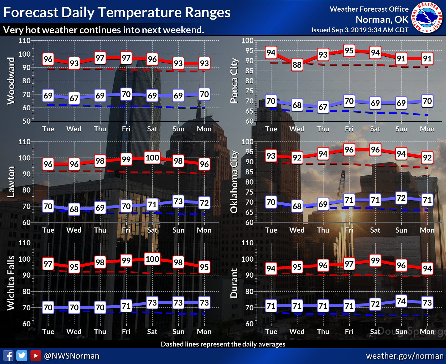
In the present, however, we're talking the under-the-heat-dome doldrums for us...
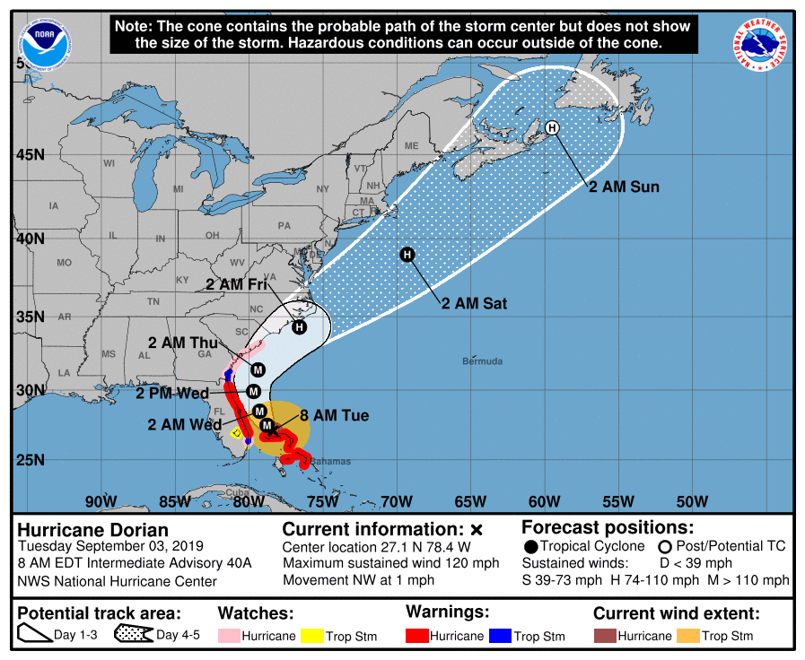
And wayyyy too much major Hurricane Dorian fueled excitement on the East Coast.
Luckily looks like the U.S. will just get a glancing blow, but still lots of
necessary anxiety over that way.
Well, we won't overwhelm you on the first day back from a long weekend. Let's
get right to the August weather recap. Do me a favor. Read it, and then tell
two friends about it. And they'll tell two friends. And they'll tell two
friends. And so on, and so on...
(I told ya to google it...you forced my hand)
-------------------------------------------------------------------------------
August Rains Tackle Drought
Sept. 3, 2019
Drought had gained a toehold across western and central Oklahoma during a hot,
dry first half of August; further spread and intensification seemed inevitable.
All the while eastern Oklahoma was being inundated by heavy rains and flooding.
Then the rains spread west, bringing a hefty dose of severe weather and drought
relief with them. Mother Nature put an exclamation point on the tumultuous
weather on August 26. A stifling day with temperatures in the 100s saw the heat
index soar as high as 118 degrees before severe storms – including an EF-1
tornado – blasted the state later that evening. Nearly 100,000 residents were
left without power as straight-line winds of up to 90 mph struck central and
northeastern Oklahoma. The tornado traveled from Logan County to just
north-northwest of Edmond, damaging trees and a few structures along its path.
Another weak tornado dropped in Beaver County on the 23rd, again damaging trees
and a few structures. The two confirmed twisters brought Oklahoma’s 2019 total
to at least 138, the second highest count since accurate records began in 1950.
The highest total of 145 tornadoes occurred in 1999.
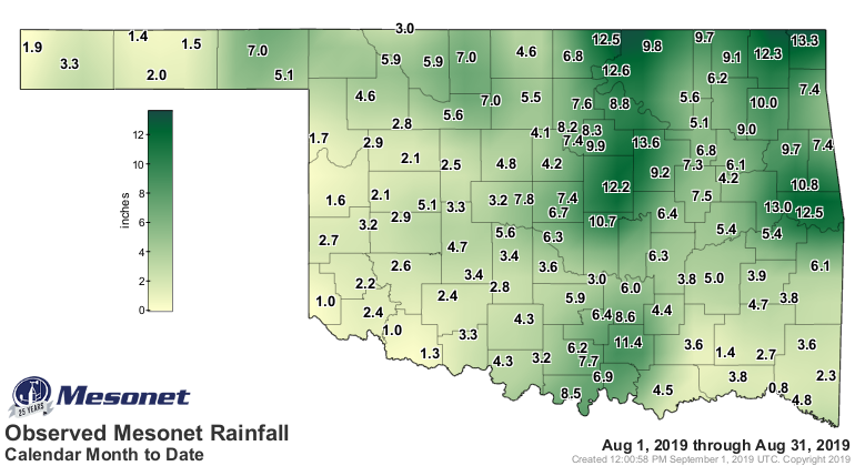
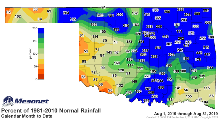
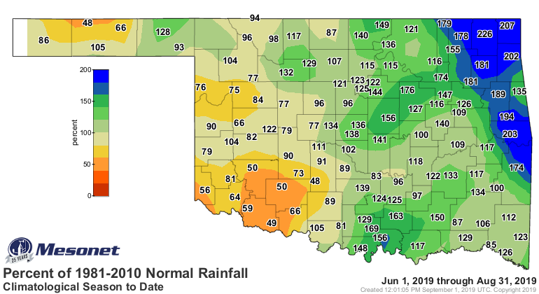
The statewide average rainfall total was 5.44 inches according to preliminary
data from the Oklahoma Mesonet, 2.49 inches above normal and ranked as the
eighth wettest August since records began in 1895. Nearly the entire state had
a surplus of moisture, save for southwestern and west central Oklahoma where
deficits of up to 2 inches occurred. Surpluses ran from 2-4 inches across
northwestern Oklahoma to more than 10 inches across the northeastern quarter
of the state. Northeastern Oklahoma experienced its wettest August on record
with an average of 8.78 inches, 5.54 inches above normal. Twelve of the
Mesonet’s 120 sites recorded at least 10 inches of rain, and another 51 had 5
inches or more. The Mesonet site at Oilton led the state with 13.64 inches.
Valliant brought up the rear with 0.81 inches, the only site that failed to
receive at least an inch of rain for the month.

The climatological summer (June-August) ended as the 30th wettest on record at
12.14 inches, 1.79 inches above normal.
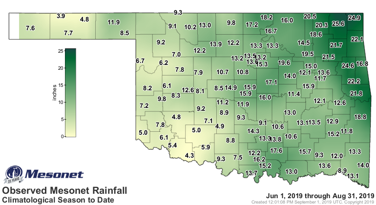
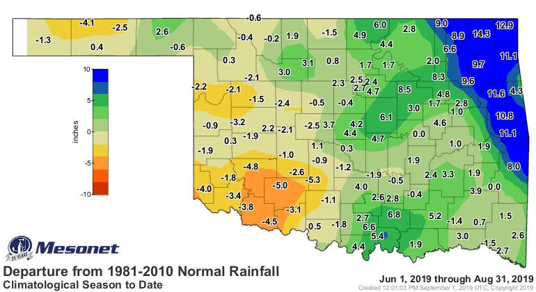
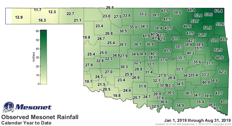
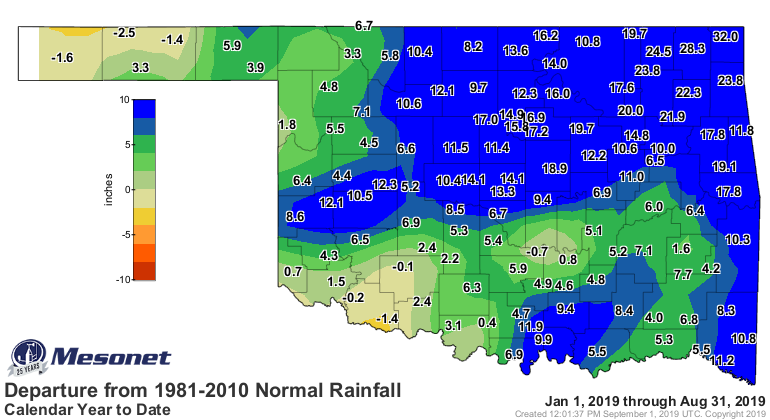
The northeast also experienced its wettest January-August on record at 47.46
inches, 18.57 inches above normal. The statewide average was 33.87 inches, 9.01
inches above normal to rank as the fifth wettest January-August on record.

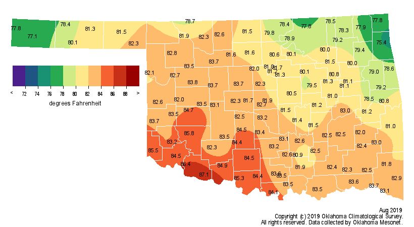
The statewide average temperature was 81.8 degrees, a degree above normal to
rank as the 46th warmest August on record. Drought-stricken western Oklahoma
was 3-4 degrees above normal, while the rainy northeast was 2-4 degrees below
normal.
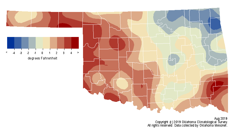
Several Mesonet sites reached 108 degrees for the highest temperature of the
month. Kenton recorded the lowest reading of 55 degrees on three separate days.
The actual air temperature failed to adequately describe the oppressive nature
of August’s heat, however. Combined with an abundance of humidity, the heat
index soared. The Mesonet’s 120 sites reached a heat index of at least 115
degrees 45 times during August, and at least 110 degrees 566 times. At least
one site reached a heat index of 105 degrees on 23 separate days. The summer
was a bit mild at 0.3 degrees below normal. The first eight months were on the
cool side – about 0.7 degrees below normal, the 48th coolest January-August on
record.
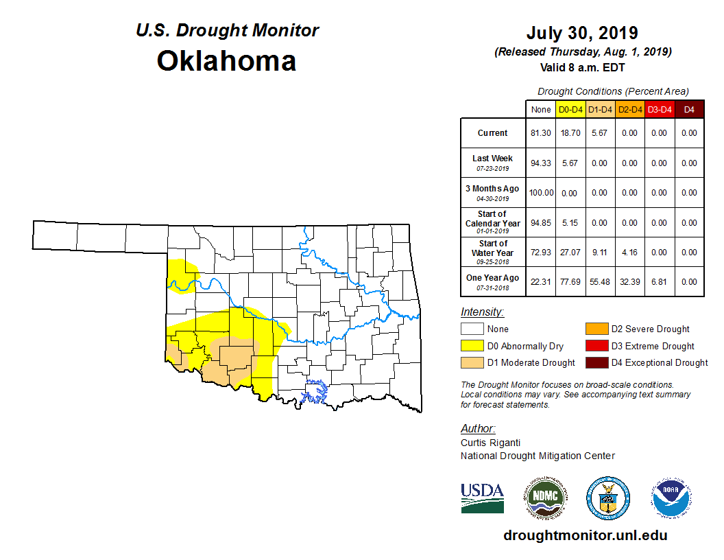
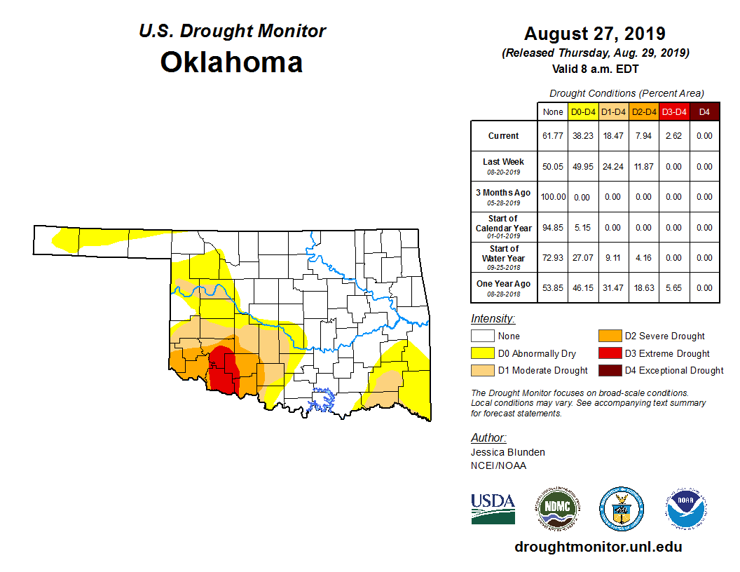
Oklahoma’s drought coverage grew from 6 percent at the end of July to nearly 24
percent by August 20, according to the U.S. Drought Monitor. While the total
coverage decreased to about 18 percent by month’s end, the drought’s intensity
increased in the parched southwestern corner of the state.
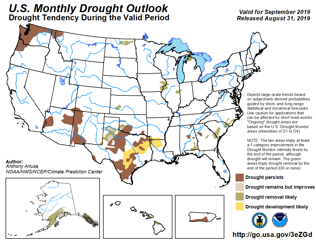
The Climate Prediction Center’s (CPC) September outlooks called for increased
odds of above normal precipitation across the northwestern half of the state,
but equal chances for above-, below-, or near-normal rainfall in the remainder
of Oklahoma. Equal odds were also indicated across the entire state for
temperature. CPC’s September drought outlook shows drought persisting in south
central Oklahoma, but some improvement is expected farther to the west. No
additional development is expected.


Gary McManus
State Climatologist
Oklahoma Mesonet
Oklahoma Climatological Survey
(405) 325-2253
gmcmanus@mesonet.org
September 3 in Mesonet History
| Record | Value | Station | Year |
|---|---|---|---|
| Maximum Temperature | 111°F | ARDM | 2000 |
| Minimum Temperature | 44°F | KENT | 2010 |
| Maximum Rainfall | 3.51 inches | COOK | 2008 |
Mesonet records begin in 1994.
Search by Date
If you're a bit off, don't worry, because just like horseshoes, “almost” counts on the Ticker website!