Ticker for May 24, 2019
MESONET TICKER ... MESONET TICKER ... MESONET TICKER ... MESONET TICKER ...
May 24, 2019 May 24, 2019 May 24, 2019 May 24, 2019
Mother Nature-rolled!

Dadblastit! Looks like our lovely time will continue. In addition to the 50 or so
tornadoes (guesstimating) we've had over the last 30 days, our rainfall has acted
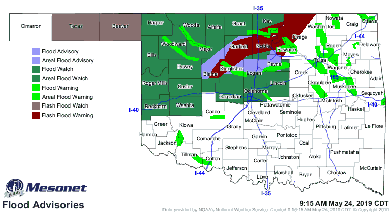
the fool just like the severe weather. Just about the entire northern half of
the state is one gigantic flood warning.
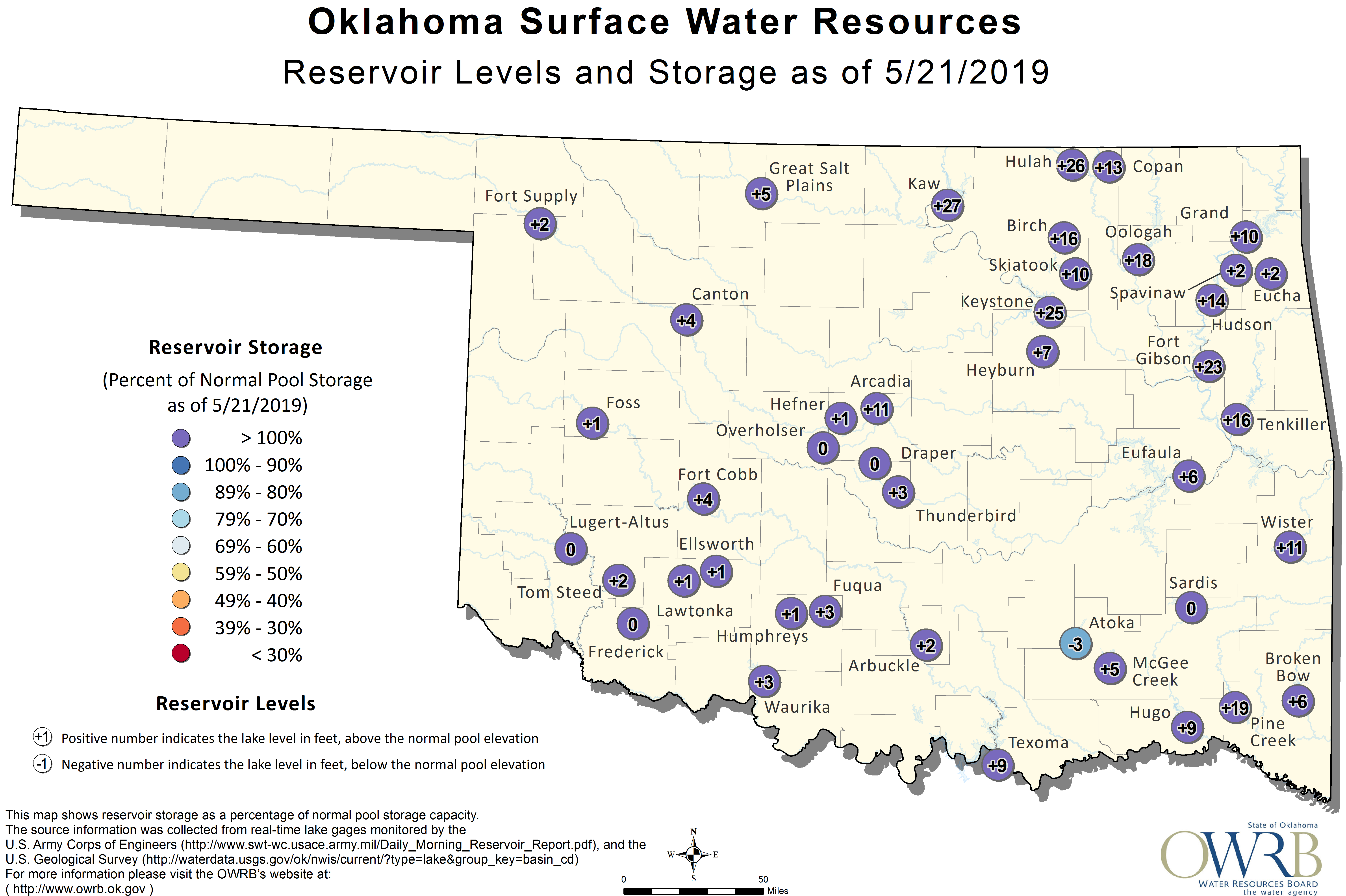
And our lakes are beyond full (note: these are from 3 Monday, before another
half-lakefull fell).
Unfortunately, it ain't over yet. What, this isn't enough over the last 30
days, Mother Nature?
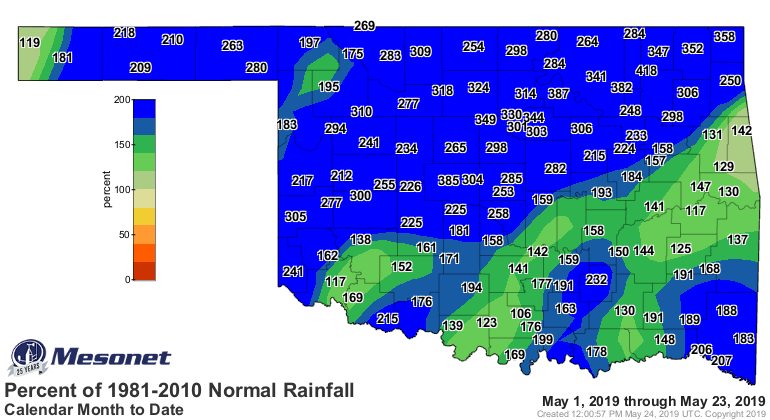
How about the 3rd wettest May 1-24 on record with a statewide average of 8.13
inches? Second wettest for NC and NE OK. Third for the WC and central sections.
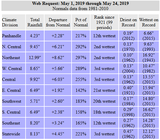
How about 6-12 inches above normal from WC through NE OK (i.e., 200-400% above
normal for that time frame)!
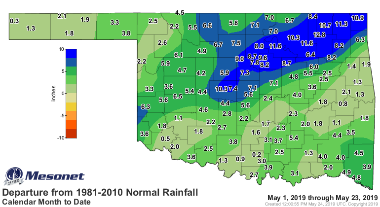
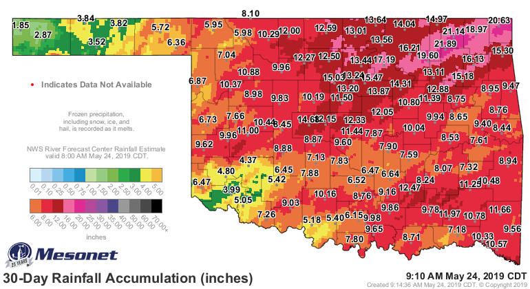
Like I said, it ain't over. Look past old Rick in the top graphic and you can
see another 3-5 inches forecast for the NW 2/3rds of the state, and then we see
another wet period on tap to end next week as well!

Why do I keep using so many exclamation points?!?! WHY NOT JUST ALL CAPS LIKE
A NORMAL PERSON?
OH YEAH, THERE WILL BE A CHANCE FOR SEVERE WEATHER ACROSS NORTHWESTERN
OKLAHOMA FOR THE NEXT FEW DAYS, THEN THE REST OF THE STATE NEXT WEEK
TUESDAY. Ugh, I think I'll stick to exclamation points! Mother Nature is!
Gary McManus
State Climatologist
Oklahoma Mesonet
Oklahoma Climatological Survey
(405) 325-2253
gmcmanus@mesonet.org
May 24 in Mesonet History
| Record | Value | Station | Year |
|---|---|---|---|
| Maximum Temperature | 111°F | TIPT | 2000 |
| Minimum Temperature | 36°F | EVAX | 2017 |
| Maximum Rainfall | 6.54 inches | MCAL | 2015 |
Mesonet records begin in 1994.
Search by Date
If you're a bit off, don't worry, because just like horseshoes, “almost” counts on the Ticker website!