Ticker for April 25, 2018
MESONET TICKER ... MESONET TICKER ... MESONET TICKER ... MESONET TICKER ...
April 25, 2018 April 25, 2018 April 25, 2018 April 25, 2018
2010: A cautionary tornado tale

As you've probably heard/read by now, if we don't see a tornado touch down in
Oklahoma by midnight tomorrow, April 26, we will have broken the modern record for
latest-first tornado in the state. The modern record (considered the most
accurate) began in 1950. Since Jan. 1, 1950, the state has seen 3824 confirmed
twisters. And of course, so far this year, ZERO. Lots of conjecture on why the
dearth. Some blame the drought. Not sure about that one. Remember in 2011, smack
dab in the middle of one of our worst drought years on record, we put up a 50
for April and a 46 for May. Some say the cold weather. Well, it hasn't been cold
the entire month, nor was it cold during March. It's a bit more complicated,
probably. It takes an almost perfect set of atmospheric circumstances to produce
a storm that will start rotating (a supercell, if you will) that will then go on
to produce a tornado. We have a lot more supercells than tornadoes, obviously.
It's like baking a cake with Mother Nature controlling all the ingredients. Maybe
she's given us a half-cup of sugar instead of a full cup. Maybe she put baking
soda in instead of baking powder. Or coffee instead of cocoa. Oh, that crazy
Mother Nature!
*Note: I don't know the ingredients to a cake, so the above might seem
nonsensical.
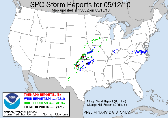
Now there have been some close ones. A look at SPC's preliminary tornado reports
for Jan. 1 through April 5 (so we're missing some) shows a couple in the Texas
Panhandle, down in the TexArkAna region and eastern Arkansas. But the low number
of hail and wind reports is also a bit remarkable. That shows a lack of not only
supercells, but also general convective storms.
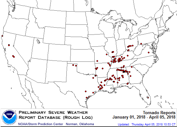
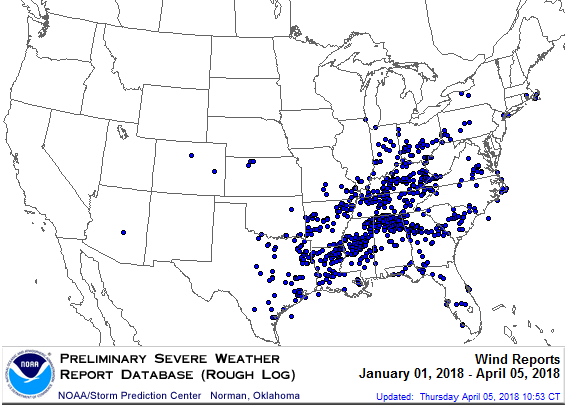
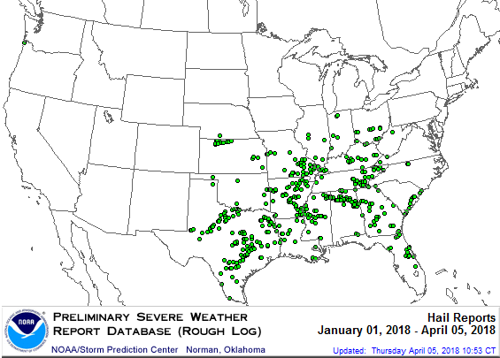
At any rate, no tornadoes so far in 2018. So we're in the clear, right? Well,
no, not by any means. Let's look back at another slow year, 2010. By this
date in 2010, we had only seen three tornadoes in Oklahoma (an EF2 bad boy in
Roger Mills and Custer counties) and a couple of EF0 wimps. Even the first
nine days of May were quiet. By May 9, 2010, we had seen the slowest start to
Oklahoma's tornado season on record.
-***-
YEAR Through May 9 Total for Year
2010 3 103
1989 4 20
1997 7 55
1998 8 83
-****-
103! Okay, there's your cautionary tale. The slowest start to the year and we
ended up with the 5th highest total on record. Tops are:
1999: 145
2011: 119
2015: 111
1957: 107
2010: 103
1982: 101
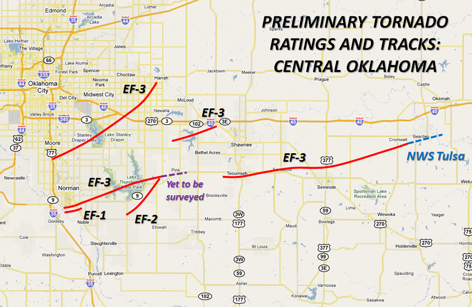
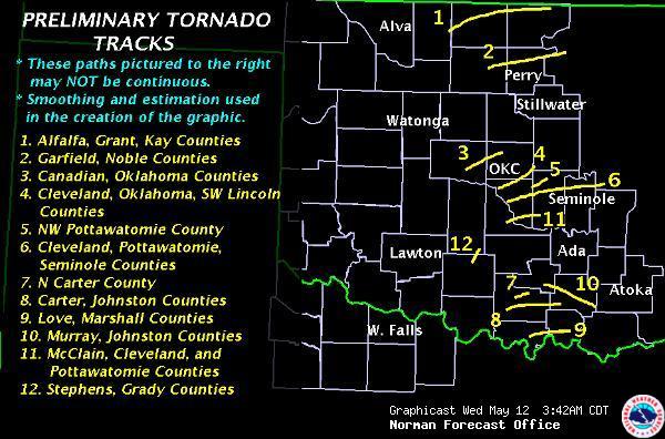
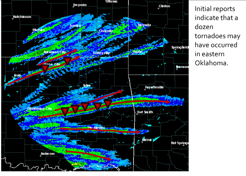
It was all going great for the state that year until May 10, then this happened.


Significant tornadoes possible. Ya think? We ended up with 56 that day,
including an EF4 monster that tore through Cleveland/Pottawatomie counties,
killing one person and injuring 32, another EF4 that traveled from far north
Norman to Harrah, killing 2 and injuring 49, and an EF3 that struck Pottawatomie
/Seminole/Okfuskee countes, injuring 28.
Heck, we had an EF2 tornado on Dec. 31 of that year to end the festivities. As
it traveled into Arkansas, it grew to EF3 intensity and killed 4, injuring 10.
So the cautionary tale...don't count your tornadoes (or lack thereof) before
your supercells are hatched. Eight years ago we were crowing about the slowest
start on record and we ended up in a world of hurt.
As the meteorologists in these parts are fond of saying...it only takes one day,
one tornado. May 10, 2010, is a perfect example.
Gary McManus
State Climatologist
Oklahoma Mesonet
Oklahoma Climatological Survey
(405) 325-2253
gmcmanus@mesonet.org
April 25 in Mesonet History
| Record | Value | Station | Year |
|---|---|---|---|
| Maximum Temperature | 105°F | ERIC | 2012 |
| Minimum Temperature | 28°F | BURN | 2013 |
| Maximum Rainfall | 4.84 inches | MEDF | 2009 |
Mesonet records begin in 1994.
Search by Date
If you're a bit off, don't worry, because just like horseshoes, “almost” counts on the Ticker website!