Ticker for March 1, 2018
MESONET TICKER ... MESONET TICKER ... MESONET TICKER ... MESONET TICKER ...
March 1, 2018 March 1, 2018 March 1, 2018 March 1, 2018
February rain records shattered!
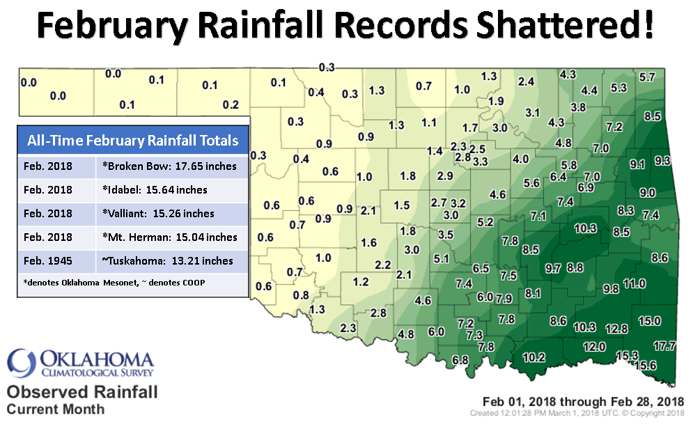
Pretty amazing, eh? Broken Bow already had the all-time February rainfall record
from Tuskahoma(1945) beat but another 4 inches or so in the last 24 hours bumped
them from "beating" the record to "shattering/obliterating/savaging" the record.
And keep in mind the totals listed on the graphic are just from the Oklahoma
Mesonet. Many of the NWS COOP sites are still not in yet, so there's a chance
that the Broken Bow COOP site could push the record even higher. Right now, their
incomplete total stands at 13.89 inches. COOP rainfall reports date back to 1870
while the Mesonet rainfall data extends back to 1994.
The northwest can only look on in despair and envy as their dry spell continues
*barely* interrupted. Not much rain in the forecast, except for *GASP!!!*
southeastern Oklahoma.
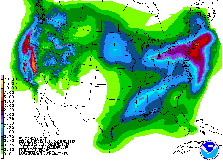
I'm shocked. SHOCKED I SAY! But, it's not much this go-round. But there was a lot
more to February than just prodigious rainfall. So lay on, Macduff (for you
Shakespearean misquoters, "lead on, Macduff" will do) and let's get to the
February facts and figures.
-------------------------------------------------------------------------------
February rain records were shattered as a series of storm systems during the
month?s final week brought snow, sleet and heavy rains to Oklahoma. The
unsettled weather dumped a season?s worth of moisture over the southeastern
half of the state and provided a brief brush with wintry weather. Kids across
the state finally enjoyed a snow day or two as slippery travel shut down
schools. The Oklahoma Mesonet site at Broken Bow led the state with an
astounding 17.65 inches of rainfall, the highest total ever recorded in
Oklahoma during February. At nearly 14 inches above normal, the total shattered
the previous February record of 13.21 inches set by Tuskahoma in February 1945.
The Mesonet sites at Idabel, Mt. Herman, and Valliant each had at least 15
inches, also besting the previous state record. At least a dozen locations saw
their February rain records fall. According to preliminary data from the
Oklahoma Mesonet, the statewide average finished at 4.33 inches to rank as the
second wettest February on record, 2.50 inches above normal. Those records date
back to 1895.

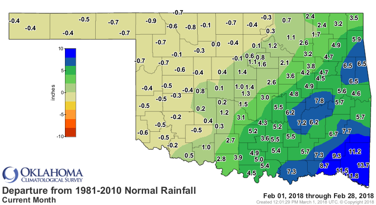
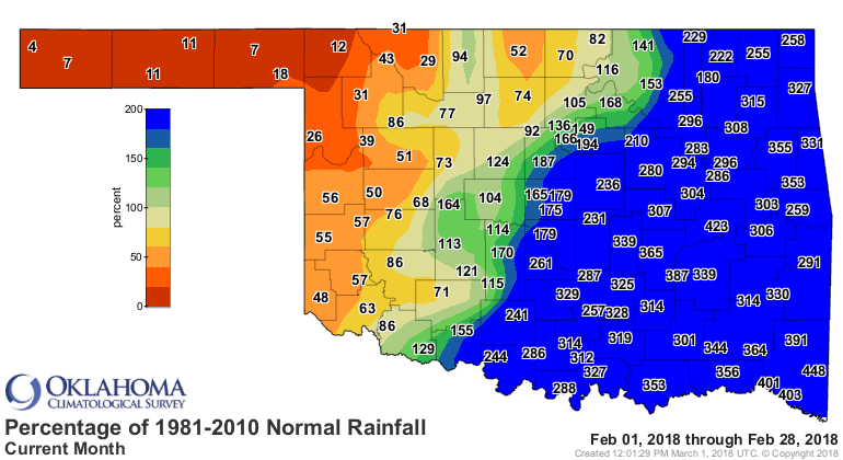
While the southeast dealt with record wetness and flooding, the dry streak in
the northwest that dated back to early October continued unabated, creating a
stark contrast between the ?haves? to the southeast and the ?have-nots? in the
northwest.The southeast corner experienced its wettest February on record with
an average total of 12.82 inches, 9.45 inches above normal. In contrast, the
Panhandle was more than a half-inch below normal for their eighth driest
February on record. Thirty of the Mesonet?s 120 sites recorded an inch of rain
or less, with six of those receiving less than a tenth of an inch. On the other
side of the scale, 50 sites recorded more than 5 inches with 10 of those
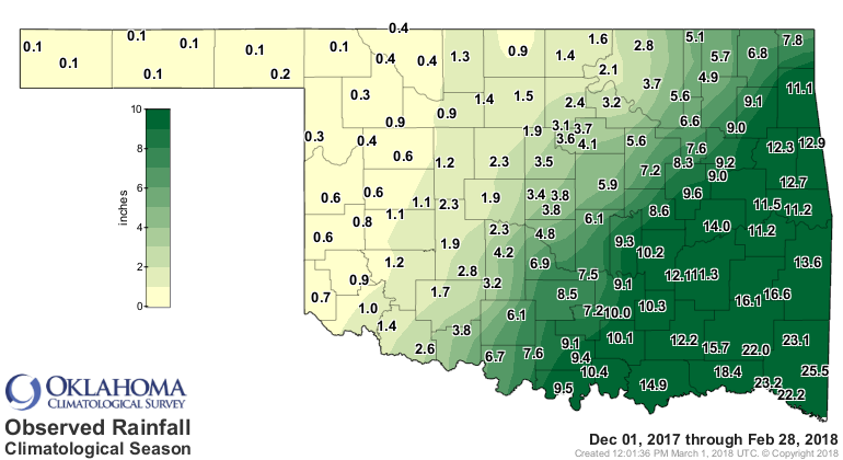
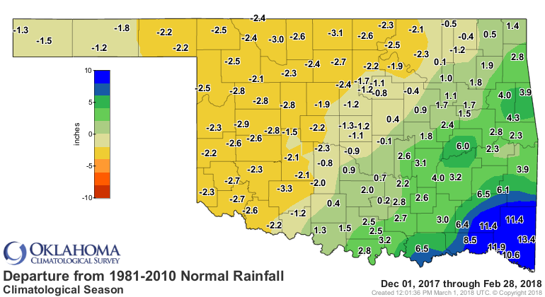
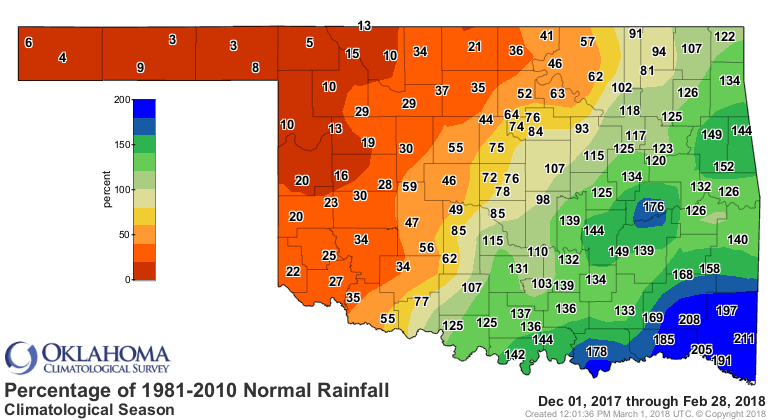
receiving more than 10 inches. The climatological winter (December-February)
displayed similar disparate statistics, again owed largely to the final week of
February. The Panhandle region suffered through its driest winter on record
with an average of 0.12 inches, 1.79 inches below normal. The southeast?s
average of 18.32 inches was 7.84 inches above normal and ranked as their third
wettest on record. The statewide average finished at 5.78 inches, 0.33 inches
above normal to rank as the 35th wettest winter on record.
February temperatures came in cooler than normal. The statewide average was
40.8 degrees, 1.3 degrees below normal and ranked as the 56th coolest February
on record. Several sites shared the month?s top temperature reading of 84
degrees on Feb. 14 and 15. Camargo recorded the lowest temperature of minus 1
degree on Feb. 12.

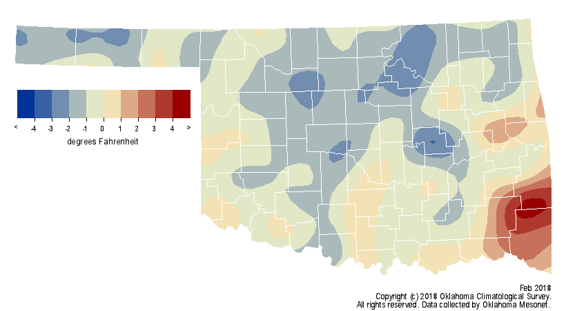
The winter finished a tad below normal at 39.1 degrees, the 56th coolest on
record.
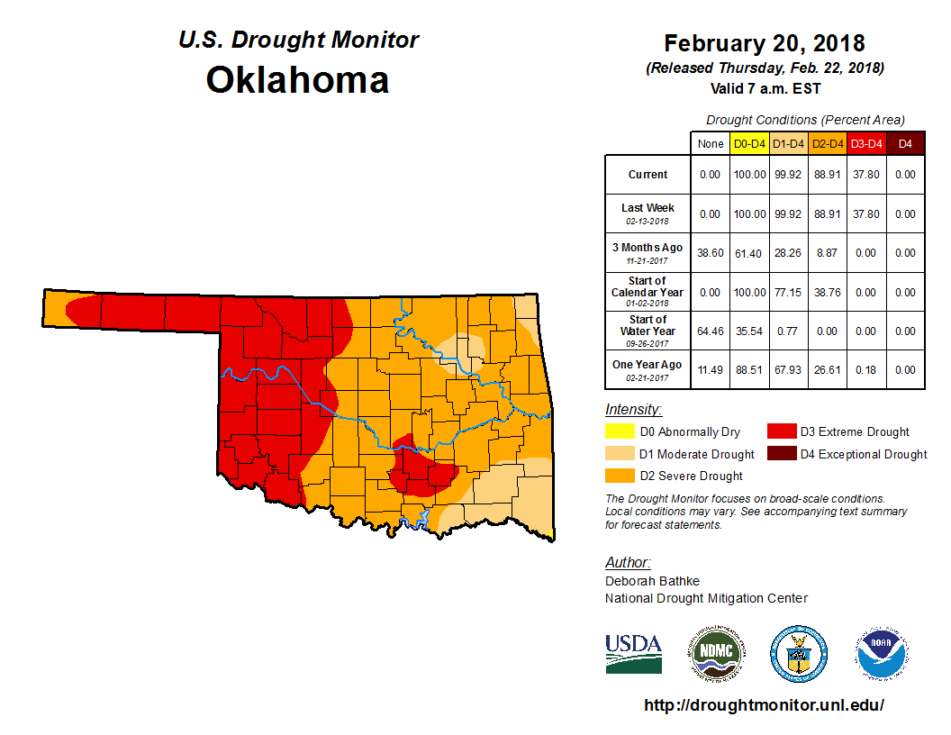
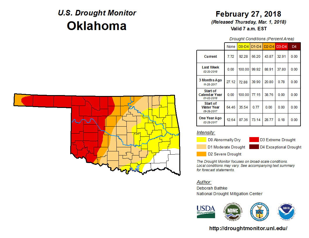
The late-month bounty dramatically improved the drought situation across much
of the state. According to the latest U.S. Drought Monitor report, which
considered precipitation through Feb. 27, 66 percent of the state remains in
some form of drought. That?s a reduction of 34 percent from the previous week.
Nearly 44 percent of that drought is still considered ?severe? or ?extreme,?
covering most of western Oklahoma into the Panhandle. The Drought Monitor?s
intensity scale slides from moderate-severe-extreme-exceptional, with
exceptional being the worst classification.
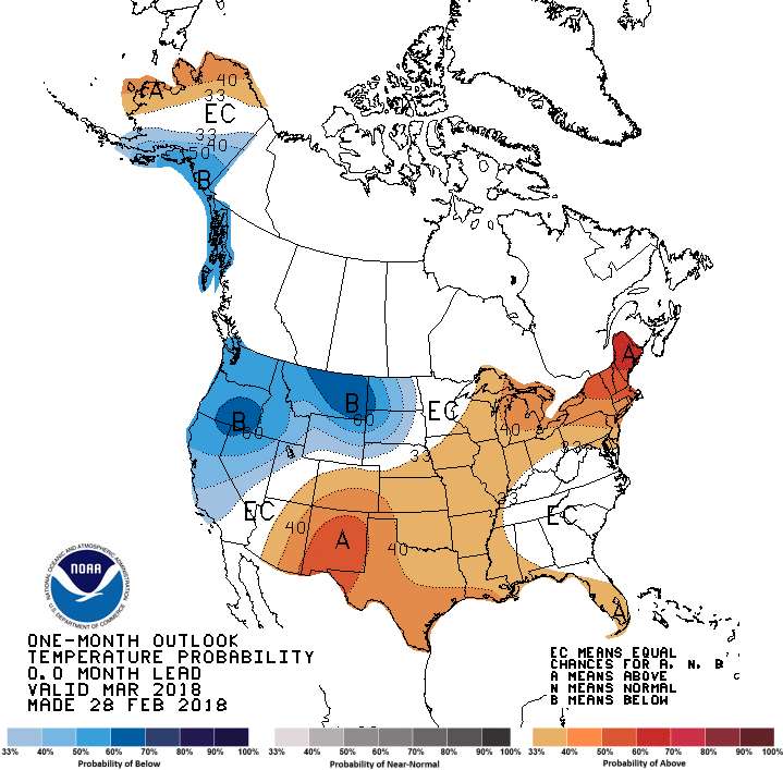
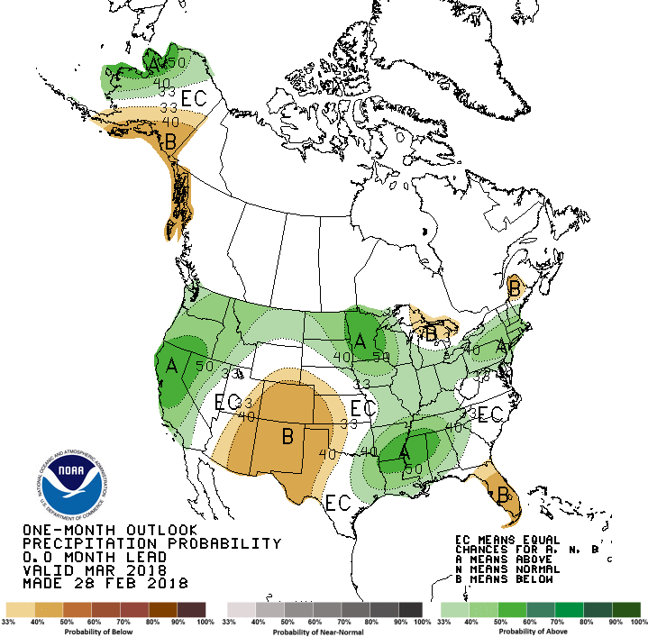
The outlooks for March from the Climate Prediction Center (CPC) call for
increased odds of above normal temperatures across all of Oklahoma and below
normal precipitation across the western half of the state. Those odds are
greatest across far western Oklahoma and the Panhandle. There are also increased
odds of above normal precipitation across far southeastern Oklahoma.
CPC?s Monthly Drought Outlook for March therefore depicts drought either
persisting or increasing across the western half and into the far northeastern
corner of the state. Drought improvement or removal is likely across the
remainder of Oklahoma.

Gary McManus
State Climatologist
Oklahoma Mesonet
Oklahoma Climatological Survey
(405) 325-2253
gmcmanus@mesonet.org
March 1 in Mesonet History
| Record | Value | Station | Year |
|---|---|---|---|
| Maximum Temperature | 95°F | NEWP | 2006 |
| Minimum Temperature | 7°F | GOOD | 2001 |
| Maximum Rainfall | 1.86″ | HUGO | 1997 |
Mesonet records begin in 1994.
Search by Date
If you're a bit off, don't worry, because just like horseshoes, “almost” counts on the Ticker website!